- National Register of Historic Places listings in Warren County, Iowa
-
 Location of Warren County in Iowa
This is a list of the National Register of Historic Places listings in Warren County, Iowa.
This is intended to be a complete list of the properties and districts on the National Register of Historic Places in Warren County, Iowa, United States. Latitude and longitude coordinates are provided for many National Register properties and districts; these locations may be seen together in a Google map.[1]
There are 12 properties and districts listed on the National Register in the county.
-
- This National Park Service list is complete through NPS recent listings posted November 10, 2011.[2]
Current listings
[3] Landmark name[4] Image Date listed Location City or Town Summary 1 Coal Creek Bridge May 15, 1998 2404 Fillmore St. over Coal Creek
41°25′44″N 93°20′46″W / 41.42889°N 93.34611°WCarlisle 2 Hoosier Row School June 23, 2011 15246 County Road R63
41°18′15″N 93°37′2″W / 41.30417°N 93.61722°WIndianola vicinity 3 Indianola High School October 24, 2002 301 N. Buxton
41°21′46″N 93°33′45″W / 41.36278°N 93.5625°WIndianola 4 Lake Ahquabi State Park, Picnic Area (Area A) November 15, 1990 1650 118th Ave.
41°17′23″N 93°35′1″W / 41.28972°N 93.58361°WIndianola 5 Lake Ahquabi State Park, Bathhouse Area (Area B) November 15, 1990 1650 118th Ave.
41°17′25″N 93°35′25″W / 41.29028°N 93.59028°WIndianola 6 Lake Ahquabi State Park, Refectory Area (Area C) November 15, 1990 1650 118th Ave.
41°17′19″N 93°35′25″W / 41.28861°N 93.59028°WIndianola 7 Octagon Barn, Otter Township June 30, 1986 Off Iowa Highway 205
41°16′7″N 93°26′35″W / 41.26861°N 93.44306°WOtter Township 8 Palmyra Methodist Episcopal Church October 1, 1979 Southwest of Hartford
41°26′4″N 93°26′5″W / 41.43444°N 93.43472°WPalmyra 9 Polled Hereford Breed Origin Site June 24, 1983 Southwest of Indianola
41°15′32″N 93°40′54″W / 41.25889°N 93.68167°WIndianola 10 Science Hall 
May 8, 1991 Simpson College campus
41°21′54″N 93°34′25″W / 41.365°N 93.57361°WIndianola 11 United Presbyterian Church, Summerset November 7, 1976 U.S. Route 65
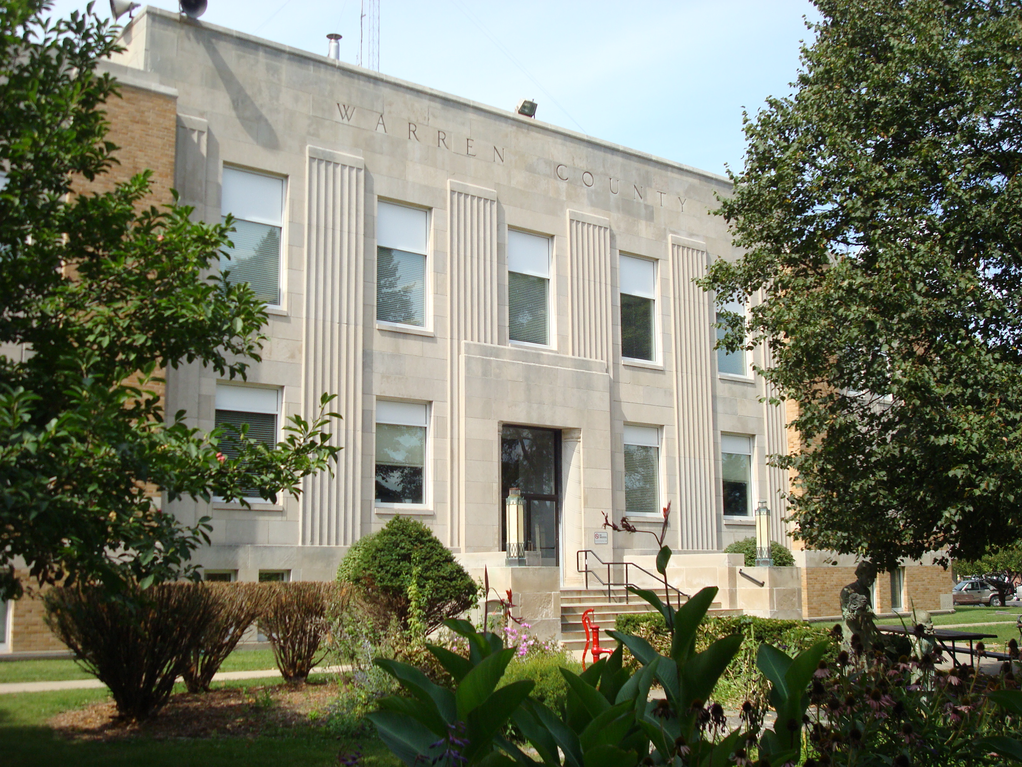
41°28′16″N 93°33′38″W / 41.47111°N 93.56056°WScotch Ridge 12 Warren County Court House 
August 28, 2003 115 N. Howard Ave.
41°21′40″N 93°33′41″W / 41.36111°N 93.56139°WIndianola See also
References
- ^ The latitude and longitude information provided in this table was derived originally from the National Register Information System, which has been found to be fairly accurate for about 99% of listings. For about 1% of NRIS original coordinates, experience has shown that one or both coordinates are typos or otherwise extremely far off; some corrections may have been made. A more subtle problem causes many locations to be off by up to 150 yards, depending on location in the country: most NRIS coordinates were derived from tracing out latitude and longitudes off of USGS topographical quadrant maps created under the North American Datum of 1927, which differs from the current, highly accurate WGS84 GPS system used by Google maps. Chicago is about right, but NRIS longitudes in Washington are higher by about 4.5 seconds, and are lower by about 2.0 seconds in Maine. Latitudes differ by about 1.0 second in Florida. Some locations in this table may have been corrected to current GPS standards.
- ^ "National Register of Historic Places: Weekly List Actions". National Park Service, United States Department of the Interior. Retrieved on November 10, 2011.
- ^ Numbers represent an ordering by significant words. Various colorings, defined here, differentiate National Historic Landmark sites and National Register of Historic Places Districts from other NRHP buildings, structures, sites or objects.
- ^ "National Register Information System". National Register of Historic Places. National Park Service. 2008-04-24. http://nrhp.focus.nps.gov/natreg/docs/All_Data.html.
U.S. National Register of Historic Places Topics Lists by states Alabama • Alaska • Arizona • Arkansas • California • Colorado • Connecticut • Delaware • Florida • Georgia • Hawaii • Idaho • Illinois • Indiana • Iowa • Kansas • Kentucky • Louisiana • Maine • Maryland • Massachusetts • Michigan • Minnesota • Mississippi • Missouri • Montana • Nebraska • Nevada • New Hampshire • New Jersey • New Mexico • New York • North Carolina • North Dakota • Ohio • Oklahoma • Oregon • Pennsylvania • Rhode Island • South Carolina • South Dakota • Tennessee • Texas • Utah • Vermont • Virginia • Washington • West Virginia • Wisconsin • WyomingLists by territories Lists by associated states Other Municipalities and communities of Warren County, Iowa Cities Ackworth | Bevington‡ | Carlisle‡ | Cumming | Des Moines‡ | Hartford | Indianola | Lacona | Martensdale | Milo | New Virginia | Norwalk‡ | Sandyville | Spring Hill | St. Marys | West Des Moines‡

Unincorporated
communitiesBeech | Churchville | Liberty Center | Prole
Footnotes ‡This populated place also has portions in an adjacent county or counties
Categories:- National Register of Historic Places in Iowa by county
- Warren County, Iowa
- Buildings and structures in Warren County, Iowa
-


Wikimedia Foundation. 2010.