- National Register of Historic Places listings in Madison County, Iowa
-
 Location of Madison County in Iowa
This is a list of the National Register of Historic Places listings in Madison County, Iowa.
This is intended to be a complete list of the properties and districts on the National Register of Historic Places in Madison County, Iowa, United States. Latitude and longitude coordinates are provided for many National Register properties and districts; these locations may be seen together in a Google map.[1]
There are 47 properties listed on the National Register in the county.
-
- This National Park Service list is complete through NPS recent listings posted November 10, 2011.[2]
[3] Landmark name [4] Image Date listed Location City or town Summary 1 James Allen Stone Barn September 29, 1987 2½ miles southeast of Earlham
41°26′56″N 94°06′20″W / 41.448889°N 94.105556°WEarlham 2 George and Susan Guiberson Armstrong House September 29, 1987 2½ miles north of Winterset on G4R
41°23′17″N 93°58′24″W / 41.388056°N 93.973333°WWinterset 3 C.D. and Eliza Heath Bevington Privy September 29, 1987 805 S. 2nd Ave.
41°19′11″N 94°00′49″W / 41.319722°N 94.013611°WWinterset 4 C.D. Bevington House and Stone Barn December 12, 1976 805 S. 2nd Ave.
41°19′39″N 94°01′09″W / 41.3275°N 94.019167°WWinterset 5 Seymour Church House September 29, 1987 U.S. Route 169
41°24′04″N 94°02′24″W / 41.401111°N 94.04°WWinterset 6 W.J. and Nettie J. Cornell House January 11, 1991 602 W. Court Ave.
41°20′03″N 94°01′15″W / 41.334167°N 94.020833°WWinterset 7 J.D. Craven Women's Relief Corps Hall January 19, 1984 South St.
41°12′07″N 94°09′25″W / 41.201944°N 94.156944°WMacksburg 8 Cunningham Bridge May 15, 1998 Upland Trail over the North River
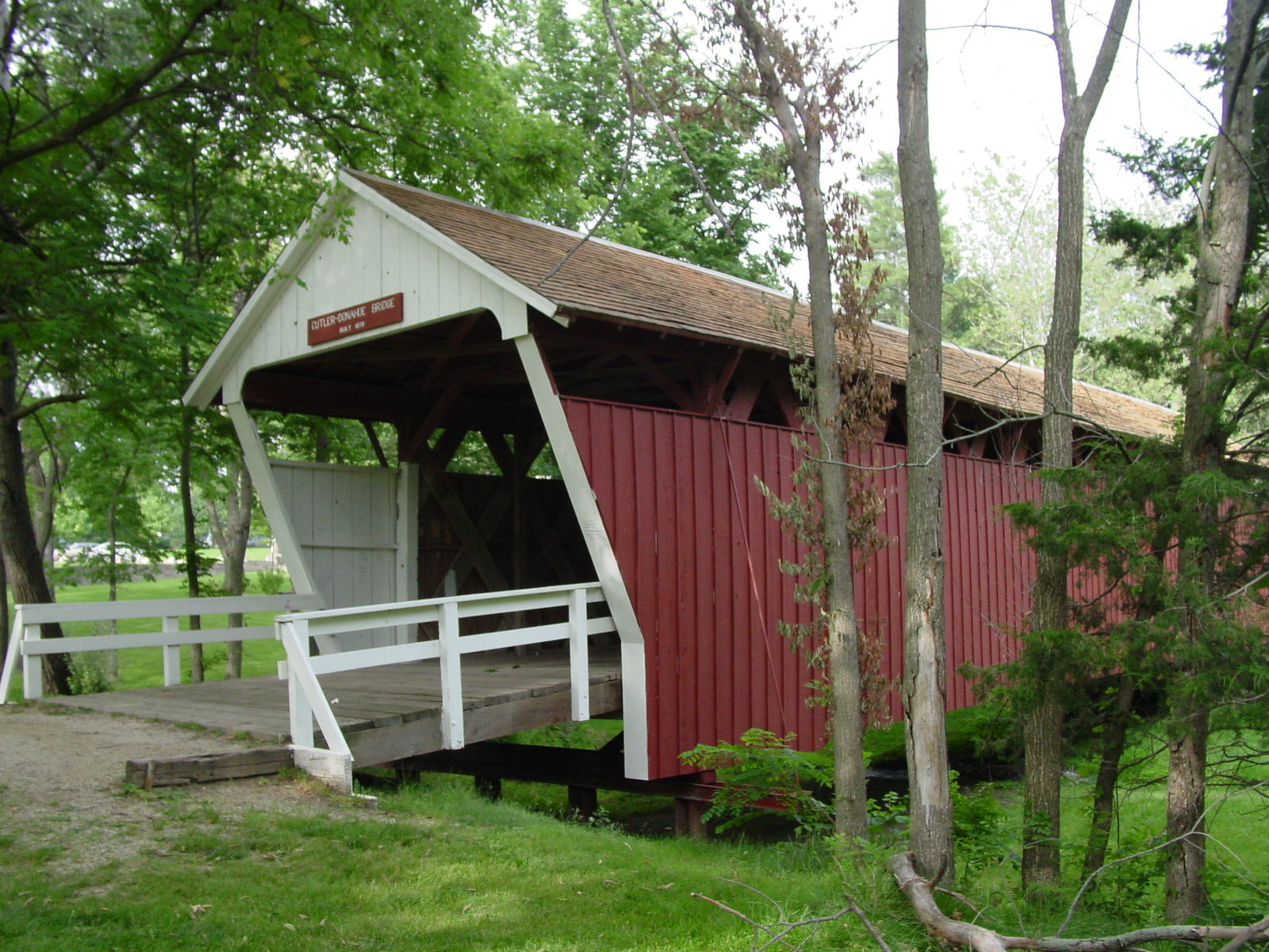
41°24′06″N 93°51′40″W / 41.401667°N 93.861111°WBevington 9 Cutler-Donahoe Covered Bridge 
October 8, 1976 Winterset City Park
41°19′52″N 94°00′31″W / 41.331111°N 94.008611°WWinterset 10 John and Amanda Bigler Drake House September 29, 1987 11 miles west of Winterset on Iowa Highway 92
41°18′57″N 94°13′21″W / 41.315833°N 94.2225°WWinterset 11 Duff Barn March 18, 1993 1½ miles north of Winterset on U.S. Route 169
41°22′03″N 94°00′51″W / 41.3675°N 94.014167°WWinterset 12 John M. Duncan House September 29, 1987 ½ mile south of Winterset on County Road P69
41°19′12″N 94°00′59″W / 41.32°N 94.016389°WWinterset 13 Earlham Public School June 2, 1982 809 Main St.
41°29′28″N 94°08′04″W / 41.491111°N 94.134444°WEarlham 14 John and Elizabeth McMurn Early House March 18, 1993 1 mile south of County Road G31 between County Roads P53 and P57
41°23′21″N 94°09′27″W / 41.389167°N 94.1575°WEarlham 15 Henry and Elizabeth Adkinson Evans House September 29, 1987 ½ mile east of U.S. Route 169 on County Road G50
41°18′42″N 93°59′33″W / 41.311667°N 93.9925°WWinterset 16 W.T. Ford House September 29, 1987 2½ miles south of Earlham on County Road P57
41°27′13″N 94°08′06″W / 41.453611°N 94.135°WEarlham 17 Guiberson House July 10, 1979 302 S. 4th Ave.
41°19′55″N 94°01′14″W / 41.331944°N 94.020556°WWinterset 18 Daniel and Nancy Swaford Henderson House September 29, 1987 8 miles south of Earlham on County Road P57
41°22′37″N 94°07′55″W / 41.376944°N 94.131944°WEarlham 19 Hogback Covered Bridge 
August 28, 1976 4 miles north of Winterset
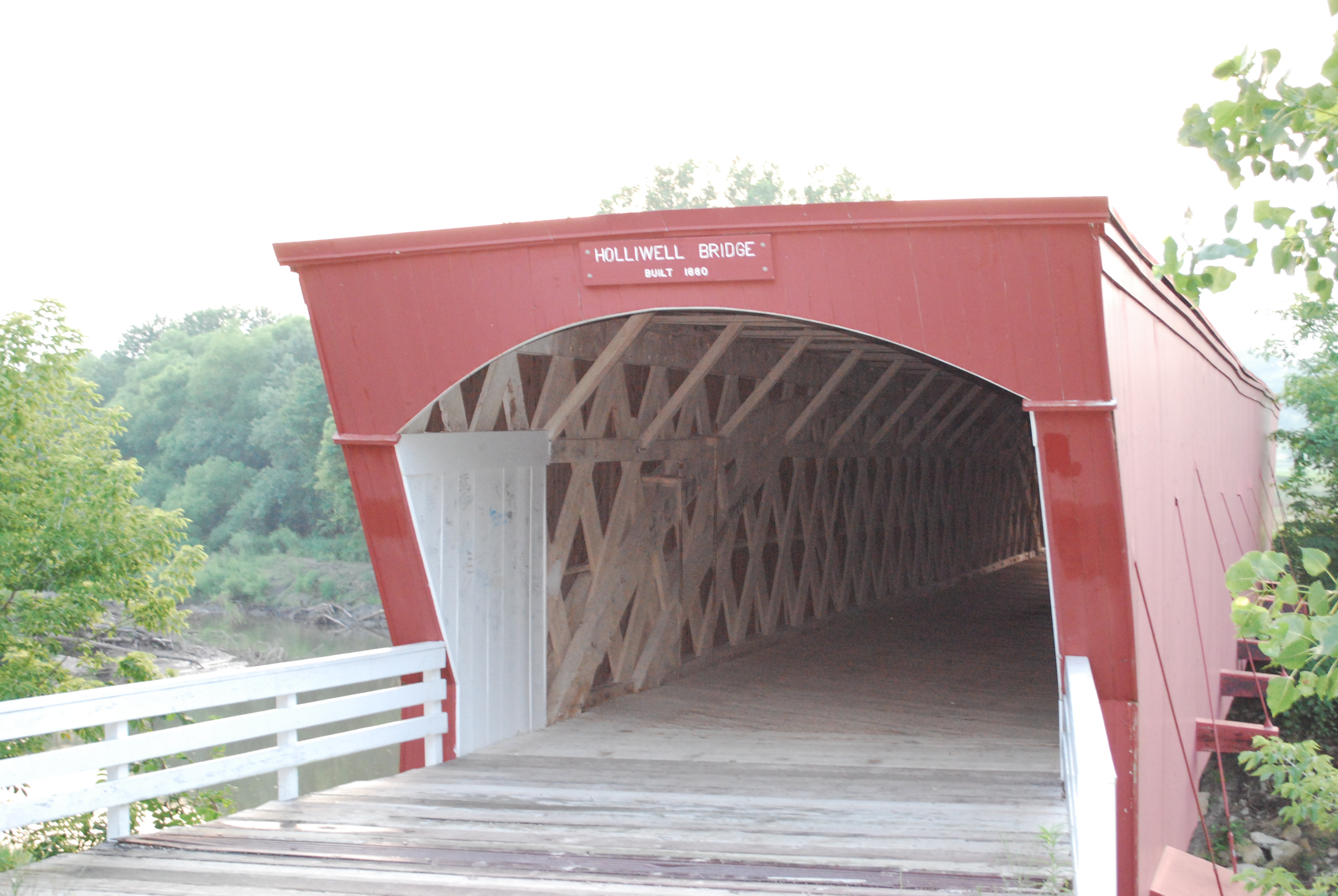
41°23′09″N 94°03′00″W / 41.385833°N 94.05°WWinterset 20 Holliwell Covered Bridge 
August 28, 1976 4 miles southeast of Winterset
41°19′21″N 93°57′33″W / 41.3225°N 93.959167°WWinterset 21 John S. and Elizabeth Beem Holmes Barn September 29, 1987 County Road G50
41°17′00″N 93°57′14″W / 41.283333°N 93.953889°WSt. Charles 22 Emily Hornback House September 29, 1987 605 N. 1st St.
41°20′22″N 94°00′46″W / 41.339444°N 94.012778°WWinterset 23 Imes Covered Bridge 
February 9, 1979 Iowa Highway 251
41°17′18″N 93°47′56″W / 41.288333°N 93.798889°WSt. Charles 24 John Andrew and Sara Macumber Ice House March 18, 1993 On County Road G53 1½ miles east of its junction with County Road P69
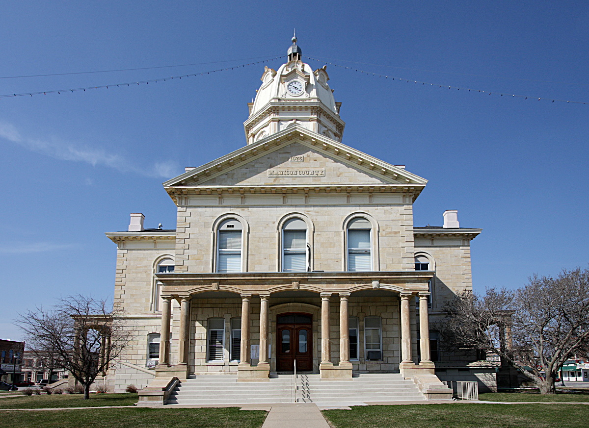
41°15′04″N 94°03′54″W / 41.251111°N 94.065°WWinterset 25 Madison County Courthouse 
August 13, 1976 City Sq.
41°19′58″N 94°01′01″W / 41.332778°N 94.016944°WWinterset 26 McDonald House March 18, 1993 3½ miles west of Winterset off Iowa Highway 92
41°21′32″N 94°05′31″W / 41.358889°N 94.091944°WWinterset 27 Peter and Isabelle McCulloch McQuie Milkhouse September 29, 1987 Southwest of Earlham
41°25′51″N 94°09′34″W / 41.430833°N 94.159444°WEarlham 28 Miller Bridge May 15, 1998 McBride Trail over an unnamed stream
41°24′45″N 93°56′34″W / 41.4125°N 93.942778°WWinterset 29 Morgan Bridge May 15, 1998 Maple Lane over a branch of Clanton Creek
41°10′16″N 93°55′55″W / 41.171111°N 93.931944°WOld Peru 30 William Anzi Nichols House September 29, 1987 1 mile east of Winterset on Iowa Highway 92
41°20′42″N 93°59′57″W / 41.345°N 93.999167°WWinterset 31 North River Stone Schoolhouse April 11, 1977 North of Winterset off U.S. Route 169
41°24′07″N 94°02′48″W / 41.401944°N 94.046667°WWinterset 32 William Ogburn House September 29, 1987 1½ miles north of East Peru
41°15′03″N 93°55′19″W / 41.250833°N 93.921944°WEast Peru 33 Hogan and Martha A. Runkle Queen House September 29, 1987 5 miles west of St. Charles on County Road G50
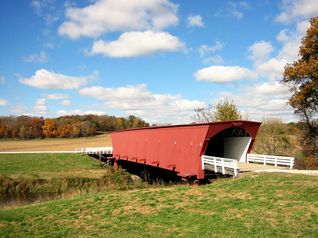
41°18′05″N 93°53′51″W / 41.301389°N 93.8975°WSt. Charles 34 Roseman Covered Bridge 
September 1, 1976 West of Winterset off Iowa Highway 92
41°17′31″N 94°09′05″W / 41.291944°N 94.151389°WWinterset 35 St. Patrick's Church December 12, 1978 Northwest of Cumming
41°25′37″N 93°47′30″W / 41.426944°N 93.791667°WCumming 36 John and Fredericka Meyer Schnellbacher House September 29, 1987 On County Road G47 1½ miles east of its junction with County Road P53
41°17′26″N 94°08′39″W / 41.290556°N 94.144167°WWinterset 37 Nicholas Schoenenberger House and Barn July 12, 1984 Off Iowa Highway 169
41°13′33″N 94°00′08″W / 41.225833°N 94.002222°WWinterset 38 William and Mary (Messersmith) Seerley Barn and Milkhouse-Smokehouse August 20, 2009 1840 137th Lane
41°26′45″N 94°05′24″W / 41.445833°N 94.09°WEarlham 39 William R. and Martha Foster Shriver House March 18, 1993 616 E. Court Ave.
41°20′03″N 94°00′23″W / 41.334167°N 94.006389°WWinterset 40 Hiram C. Smith House September 29, 1987 6 miles west of Winterset on Iowa Highway 92
41°19′47″N 94°08′30″W / 41.329722°N 94.141667°WWinterset 41 Hiram C. Smith Milking Shed September 29, 1987 6 miles west of Winterset on Iowa Highway 92
41°19′47″N 94°08′32″W / 41.329722°N 94.142222°WWinterset 42 Sprague, Brown, and Knowlton Store September 29, 1987 1st and Court
41°20′03″N 94°01′33″W / 41.334167°N 94.025833°WWinterset 43 Miller Richard and Mary Fisher Tidrick House March 18, 1993 122 S. 4th Ave.
41°20′01″N 94°01′05″W / 41.333611°N 94.018056°WWinterset 44 J.G. and Elizabeth S. Vawter House September 29, 1987 223 S. 1st St.
41°19′58″N 94°00′46″W / 41.332778°N 94.012778°WWinterset 45 Henry C. Wallace House January 3, 1985 422 W. Jefferson
41°19′58″N 94°01′27″W / 41.332778°N 94.024167°WWinterset 46 Munger White and Company Store September 29, 1987 102 W. Court
41°20′03″N 94°00′52″W / 41.334167°N 94.014444°WWinterset 47 Seth and Elizabeth Wilson House September 29, 1987 1¾ miles east of County Road P57 on County Road G14
41°28′10″N 94°05′39″W / 41.469444°N 94.094167°WEarlham See also
References
- ^ The latitude and longitude information provided in this table was derived originally from the National Register Information System, which has been found to be fairly accurate for about 99% of listings. For about 1% of NRIS original coordinates, experience has shown that one or both coordinates are typos or otherwise extremely far off; some corrections may have been made. A more subtle problem causes many locations to be off by up to 150 yards, depending on location in the country: most NRIS coordinates were derived from tracing out latitude and longitudes off of USGS topographical quadrant maps created under the North American Datum of 1927, which differs from the current, highly accurate WGS84 GPS system used by Google maps. Chicago is about right, but NRIS longitudes in Washington are higher by about 4.5 seconds, and are lower by about 2.0 seconds in Maine. Latitudes differ by about 1.0 second in Florida. Some locations in this table may have been corrected to current GPS standards.
- ^ "National Register of Historic Places: Weekly List Actions". National Park Service, United States Department of the Interior. Retrieved on November 10, 2011.
- ^ Numbers represent an ordering by significant words. Various colorings, defined here, differentiate National Historic Landmark sites and National Register of Historic Places Districts from other NRHP buildings, structures, sites or objects.
- ^ "National Register Information System". National Register of Historic Places. National Park Service. . http://nrhp.focus.nps.gov/natreg/docs/All_Data.html.
U.S. National Register of Historic Places Topics Lists by states Alabama • Alaska • Arizona • Arkansas • California • Colorado • Connecticut • Delaware • Florida • Georgia • Hawaii • Idaho • Illinois • Indiana • Iowa • Kansas • Kentucky • Louisiana • Maine • Maryland • Massachusetts • Michigan • Minnesota • Mississippi • Missouri • Montana • Nebraska • Nevada • New Hampshire • New Jersey • New Mexico • New York • North Carolina • North Dakota • Ohio • Oklahoma • Oregon • Pennsylvania • Rhode Island • South Carolina • South Dakota • Tennessee • Texas • Utah • Vermont • Virginia • Washington • West Virginia • Wisconsin • WyomingLists by territories Lists by associated states Other Municipalities and communities of Madison County, Iowa Cities 
Unincorporated
communityFootnotes ‡This populated place also has portions in an adjacent county or counties
Categories:- National Register of Historic Places in Iowa by county
- Madison County, Iowa
- Buildings and structures in Madison County, Iowa
-


Wikimedia Foundation. 2010.