- National Register of Historic Places listings in Johnson County, Iowa
-
 Location of Johnson County in Iowa
This is a list of the National Register of Historic Places listings in Johnson County, Iowa.
This is intended to be a complete list of the properties and districts on the National Register of Historic Places in Johnson County, Iowa, United States. Latitude and longitude coordinates are provided for many National Register properties and districts; these locations may be seen together in a Google map.[1]
There are 80 properties and districts listed on the National Register in the county, including one National Historic Landmark. One property was removed in October 2006.
-
- This National Park Service list is complete through NPS recent listings posted November 10, 2011.[2]
[3] Landmark name [4] Image Date listed Location City or town Summary 1 Ned Ashton House 
January 26, 2001 820 Park Rd.
41°40′20″N 91°33′03″W / 41.672222°N 91.550833°WIowa City 2 Charles Berryhill House May 31, 1979 414 Brown St.
41°40′13″N 91°31′46″W / 41.670278°N 91.529444°WIowa City 3 Bethel AME Church 
September 27, 2000 411 S. Governor St.
41°39′22″N 91°31′23″W / 41.656111°N 91.523056°WIowa City 4 Billingsley-Hills House January 21, 1983 629 Melrose Ave.
41°39′23″N 91°32′54″W / 41.656389°N 91.548333°WIowa City 5 Boerner-Fry Company/Davis Hotel January 27, 1983 332 E. Washington St.
41°39′37″N 91°31′49″W / 41.660278°N 91.530278°WIowa City 6 William Bostick House March 28, 1996 115 N. Gilbert St.
41°39′45″N 91°31′50″W / 41.6625°N 91.530556°WIowa City 7 Brown Street Historic District September 23, 1994 Roughly Brown St. from west of Linn St. to Governor St. and adjacent parts of intersecting streets; also the 500-800 blocks of E. Ronalds St.
41°40′15″N 91°31′42″W / 41.670833°N 91.528333°WIowa City 8 Buresh Farm April 29, 1977 West of Solon off Iowa Highway 382
41°48′35″N 91°33′46″W / 41.809722°N 91.562778°WSolon 9 Wilbur D. and Hattie Cannon House October 7, 1994 320 Melrose Ave.
41°39′23″N 91°32′42″W / 41.656389°N 91.545°WIowa City 10 Thomas C. Carson House 
September 9, 1982 906 E. College St.
41°39′33″N 91°31′21″W / 41.659167°N 91.5225°WIowa City 11 Cavanaugh-Zetek House September 16, 1977 704 Reno St.
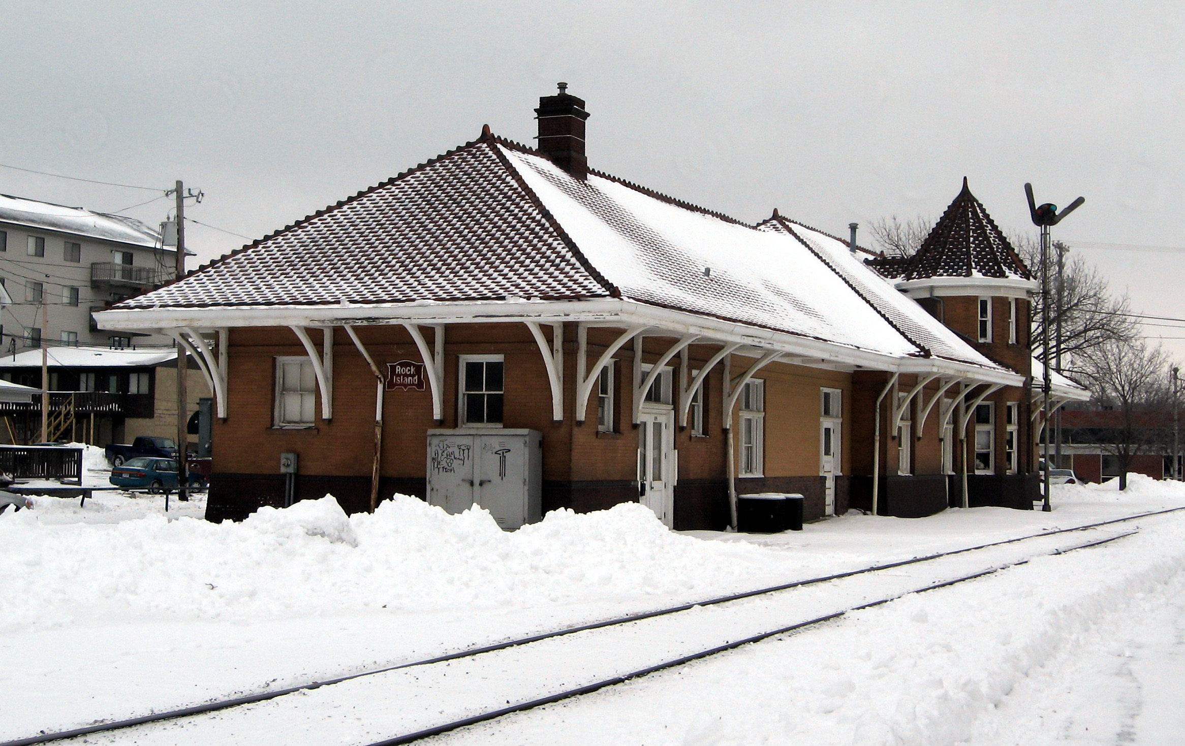
41°40′08″N 91°31′05″W / 41.668889°N 91.518056°WIowa City 12 Chicago, Rock Island and Pacific Railroad Passenger Station 
December 10, 1982 115 Wright St.
41°39′13″N 91°32′01″W / 41.653611°N 91.533611°WIowa City 13 Clark House May 16, 1996 829 Kirkwood Ave.
41°38′56″N 91°31′22″W / 41.648889°N 91.522778°WIowa City 14 Close House 
May 31, 1974 538 S. Gilbert St.
41°39′16″N 91°31′47″W / 41.654444°N 91.529722°WIowa City 15 College Block Building July 23, 1973 125 E. College St.
41°39′31″N 91°31′35″W / 41.658611°N 91.526389°WIowa City 16 College Green Historic District July 9, 1997 Roughly bounded by Burlington, Summit, Washington, and Van Buren Sts.
41°39′32″N 91°31′32″W / 41.658889°N 91.525556°WIowa City 17 Congregational Church of Iowa City June 18, 1973 30 N. Clinton St.
41°39′44″N 91°32′02″W / 41.662222°N 91.533889°WIowa City 18 Coralville Public School January 11, 1974 402-404 5th St.
41°40′26″N 91°34′12″W / 41.673889°N 91.57°WCoralville 19 Coralville Union Ecclesiastical Church April 11, 1977 405 2nd Ave.
41°40′22″N 91°33′57″W / 41.672778°N 91.565833°WCoralville 20 Cottage at Rock and Dubuque Streets January 3, 1985 Route 4, Box 3
41°48′35″N 91°29′40″W / 41.809722°N 91.494444°WSolon 21 Czecho Slovakian Association Hall November 7, 1976 524 N. Johnson St.
41°40′02″N 91°31′36″W / 41.667222°N 91.526667°WIowa City 22 East College Street Historic District July 9, 1997 Roughly bounded by Muscatine Ave., Summitt, Washington, and Burlington Sts.
41°39′28″N 91°31′40″W / 41.657778°N 91.527778°WIowa City 23 Economy Advertising Company April 28, 1986 119-123 N. Linn
41°39′48″N 91°31′53″W / 41.663333°N 91.531389°WIowa City 24 Englert Theatre 
August 30, 2001 221 E. Washington St.
41°39′35″N 91°31′56″W / 41.659722°N 91.532222°WIowa City 25 First Johnson County Asylum August 31, 1978 West of Iowa City
41°39′22″N 91°36′18″W / 41.656111°N 91.605°WIowa City 26 First Welsh Congregational Church April 13, 1977 5 miles southwest of Iowa City off Iowa Highway 1
41°36′47″N 91°36′33″W / 41.613056°N 91.609167°WIowa City 27 Arthur Hillyer Ford House April 10, 1986 228 Brown St.
41°40′14″N 91°31′48″W / 41.670556°N 91.53°WIowa City 28 Franklin Printing House April 10, 1986 115 S. Dubuque
41°39′34″N 91°32′00″W / 41.659444°N 91.533333°WIowa City 29 Gilbert-Linn Street Historic District April 21, 2005 Portions of the 300-600 blocks of N. Gilbert and N. Linn Sts.
41°40′00″N 91°31′49″W / 41.666667°N 91.530278°WIowa City 30 Emma J. Harvat and Mary E. Stach House May 11, 2000 332 E. Davenport St.
41°40′02″N 91°31′49″W / 41.667222°N 91.530278°WIowa City 31 Henyon-Kasper-Duffy Barn January 2, 2004 2520 Iowa Highway 1, NE.
41°44′58″N 91°28′20″W / 41.749444°N 91.472222°WSolon 32 Jackson-Swisher House and Carriage House November 10, 1982 120 E. Fairchild St.
41°40′02″N 91°32′00″W / 41.667222°N 91.533333°WIowa City 33 Jefferson Street Historic District September 29, 2004 Portions of the 100-400 blocks of E. Jefferson St.
41°39′46″N 91°31′51″W / 41.662778°N 91.530833°WIowa City 34 Johnson County Courthouse 
March 27, 1975 S. Clinton St.
41°39′22″N 91°32′07″W / 41.656111°N 91.535278°WIowa City 35 Sylvanus Johnson House December 6, 1990 2155 Prairie du Chien Rd.
41°41′26″N 91°31′31″W / 41.690556°N 91.525278°WIowa City 36 Kirkwood House September 17, 1974 1101 Kirkwood
41°38′57″N 91°31′09″W / 41.649167°N 91.519167°WIowa City 37 Letovsky-Rohret House April 12, 1982 515 E. Davenport St.
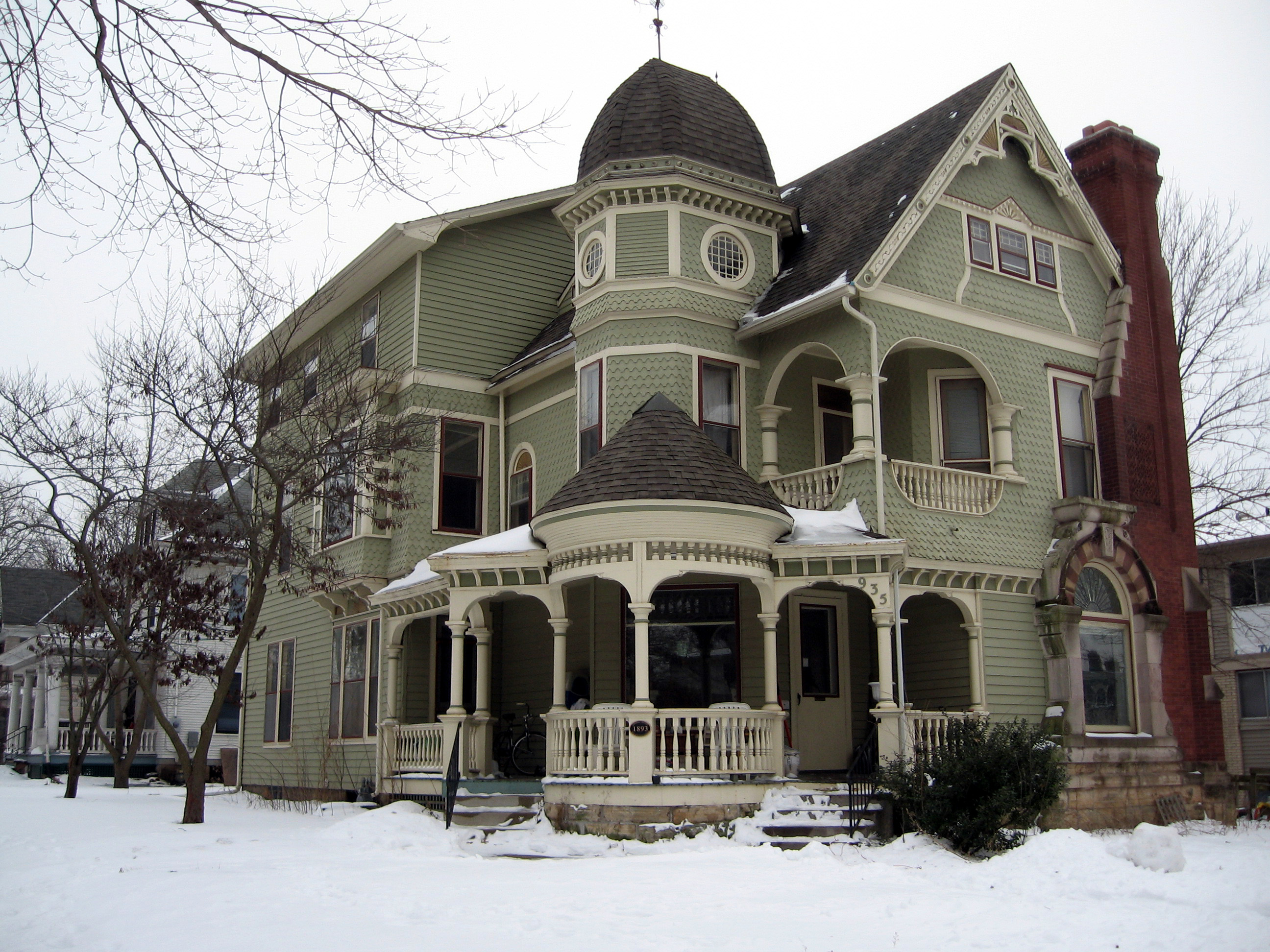
41°39′55″N 91°31′39″W / 41.665278°N 91.5275°WIowa City 38 Linsay House 
August 2, 1977 935 E. College
41°39′27″N 91°31′17″W / 41.6575°N 91.521389°WIowa City 39 Longfellow Historic District September 12, 2002 Roughly bounded by Court, Rundell, Sheridan, and the western boundary of Longfellow School
41°39′16″N 91°30′59″W / 41.654444°N 91.516389°WIowa City 40 James McCollister Farmstead October 8, 1976 Southeast of the junction of U.S. Routes 6 and 218
41°38′03″N 91°31′45″W / 41.634167°N 91.529167°WIowa City 41 Melrose Historic District December 6, 2004 Portions of Melrose Ave., Melrose Ct., Melrose Circle, Brookland Park Dr., Brookland Place, and Myrtle Ave.
41°39′21″N 91°32′45″W / 41.655833°N 91.545833°WIowa City 42 Miller Round Barn June 30, 1986 County Road F62
41°33′38″N 91°37′52″W / 41.560556°N 91.631111°WSharon Center 43 Muscatine Avenue Moffitt Cottage Historic District 
May 4, 1993 1322-1330 Muscatine Ave.
41°39′26″N 91°30′55″W / 41.657222°N 91.515278°WIowa City 44 Nicking House April 21, 1975 410 E. Market St.
41°39′49″N 91°31′45″W / 41.663611°N 91.529167°WIowa City 45 North Presbyterian Church 
August 28, 1973 26 E. Market St.
41°39′50″N 91°32′04″W / 41.663889°N 91.534444°WIowa City 46 Oakes-Wood House April 14, 1978 1142 E. Court St.
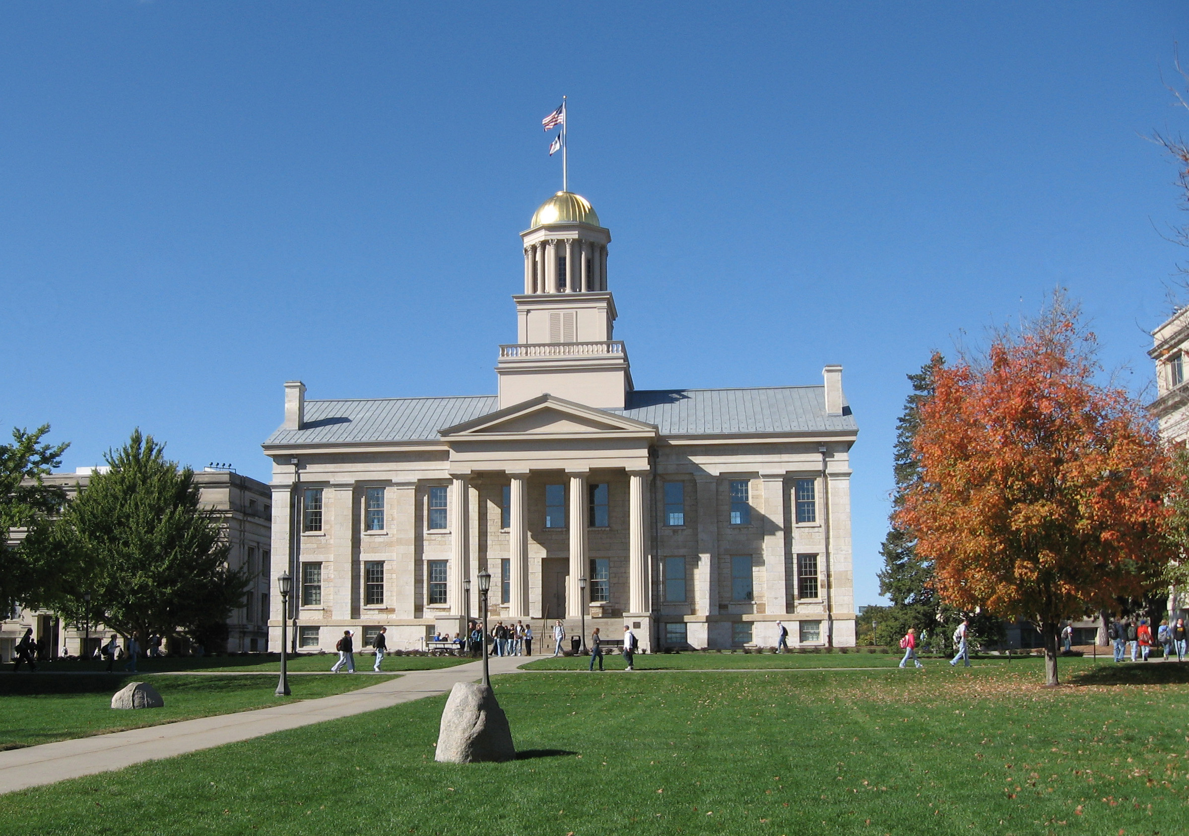
41°39′25″N 91°31′05″W / 41.656944°N 91.518056°WIowa City 47 Old Capitol 
May 31, 1972 University of Iowa campus
41°39′41″N 91°32′08″W / 41.661389°N 91.535556°WIowa City 48 Old Post Office 
April 17, 1979 28 S. Linn St.
41°39′38″N 91°31′52″W / 41.660556°N 91.531111°WIowa City 49 Oxford Commercial Historic District May 2, 1997 Roughly Augusta Ave. between Wilson St. and the Center St. alley
41°43′26″N 91°47′25″W / 41.723889°N 91.790278°WOxford 50 Park House Hotel 
December 11, 1978 130 E. Jefferson St.
41°39′46″N 91°32′00″W / 41.662778°N 91.533333°WIowa City 51 Paul-Helen Building 
April 10, 1986 207-215 E. Washington
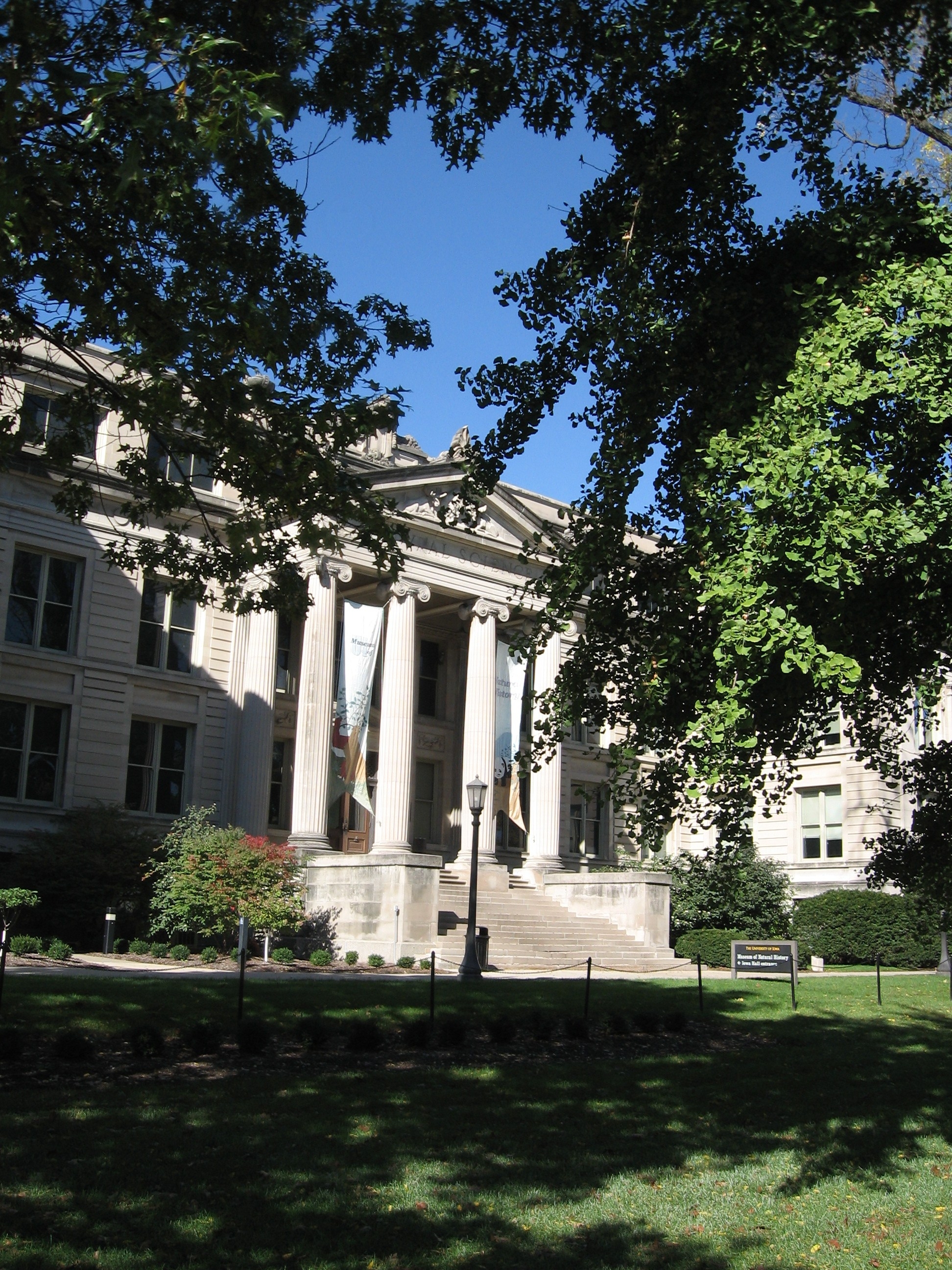
41°39′35″N 91°31′57″W / 41.659722°N 91.5325°WIowa City 52 Pentacrest 
March 29, 1978 Bounded by Clinton, Madison, Jefferson, and Washington Sts.
41°39′41″N 91°32′09″W / 41.661389°N 91.535833°WIowa City 53 Plum Grove 
May 7, 1973 1030 Carroll Ave.
41°38′52″N 91°31′28″W / 41.647778°N 91.524444°WIowa City 54 Polygonal Barn, Lincoln Township 
June 30, 1986 Off U.S. Route 6
41°35′16″N 91°23′41″W / 41.587778°N 91.394722°WLincoln Township 55 A.W. Pratt House February 3, 1983 503 Melrose Ave.
41°40′28″N 91°32′32″W / 41.674444°N 91.542222°WIowa City 56 F.X. Rittenmeyer House May 31, 1979 630 E. Fairchild St.
41°40′01″N 91°31′32″W / 41.666944°N 91.525556°WIowa City 57 Roberts Octagon Barn June 30, 1986 County Road W62
41°35′24″N 91°38′07″W / 41.59°N 91.635278°WSharon Center 58 Rose Hill April 28, 1992 1415 E. Davenport St.
41°39′57″N 91°31′01″W / 41.665833°N 91.516944°WIowa City 59 Saints Peter and Paul Catholic Church July 9, 1997 1165 NE. Taft Ave.
41°50′57″N 91°27′49″W / 41.849167°N 91.463611°WSolon 60 St. John's Lutheran Church April 5, 1977 North of Kalona
41°33′15″N 91°40′03″W / 41.554167°N 91.6675°WKalona 61 St. Mary's Church and Rectory 
February 8, 1980 220 E. Jefferson St.
41°39′46″N 91°31′54″W / 41.662778°N 91.531667°WIowa City 62 St. Mary's Rectory 
July 7, 1995 610 E. Jefferson St.
41°39′48″N 91°31′54″W / 41.663333°N 91.531667°WIowa City 63 Schindhelm-Drews House January 28, 1994 410 N. Lucas St.
41°39′58″N 91°31′27″W / 41.666111°N 91.524167°WIowa City 64 Secrest Octagon Barn November 5, 1974 West of Downey
41°36′49″N 91°22′13″W / 41.613611°N 91.370278°WDowney 65 Bohumil Shimek House December 23, 1991 529 Brown St.
41°40′11″N 91°31′37″W / 41.669722°N 91.526944°WIowa City 66 South Summit Street District October 9, 1973 301-818 S. Summit St.
41°39′16″N 91°31′16″W / 41.654444°N 91.521111°WIowa City 67 Old State Quarry February 23, 1998 0.1 miles south of the southern end of Rice Ridge Ln., NE., at Coralville Lake
41°45′48″N 91°34′13″W / 41.763333°N 91.570278°WNorth Liberty 68 Stone Academy 
January 16, 2001 Iowa Highway 1, 2 miles north of Solon
41°50′20″N 91°30′05″W / 41.838889°N 91.501389°WSolon 69 Summit Apartment Building September 29, 1983 228 S. Summit St.
41°39′29″N 91°31′14″W / 41.658056°N 91.520556°WIowa City 70 Sutliff Bridge 
May 15, 1998 Sutliff Rd. over the Cedar River
41°50′33″N 91°01′59″W / 41.8425°N 91.033056°WSutliff 71 Trinity Episcopal Church December 31, 1974 320 E. College St.
41°39′33″N 91°31′49″W / 41.659167°N 91.530278°WIowa City 72 Union Brewery April 10, 1986 127-131 N. Linn St. and 221-227 E. Market St.
41°39′48″N 91°31′54″W / 41.663333°N 91.531667°WIowa City 73 Van Patten House 
January 27, 1983 9 S. Linn St.
41°39′38″N 91°30′57″W / 41.660556°N 91.515833°WIowa City 74 Vogt House July 24, 1978 800 N. Van Buren St.
41°40′15″N 91°31′42″W / 41.670833°N 91.528333°WIowa City 75 Washington Township Center High School December 15, 1979 Northeast of Amish
41°33′20″N 91°46′12″W / 41.555556°N 91.77°WWashington Township 76 Isaac A. Wetherby House March 17, 2009 611 North Governor Street
41°40′05″N 91°31′23″W / 41.668056°N 91.522917°WIowa City 77 Jacob Wentz House August 27, 1974 219 N. Gilbert St.
41°39′51″N 91°31′48″W / 41.664167°N 91.53°WIowa City 78 H.A. White General Store and House January 12, 1984 10 W. Cherry St.
41°45′33″N 91°35′52″W / 41.759167°N 91.597778°WNorth Liberty 79 Windrem House September 13, 1977 604 Iowa Ave.
41°39′41″N 91°31′36″W / 41.661389°N 91.526667°WIowa City 80 Woodlawn Historic District March 26, 1979 Irregular pattern along Woodlawn Ave.
41°39′40″N 91°31′10″W / 41.661111°N 91.519444°WIowa City Former listings
[3] Landmark name Image Date listed Location City or town Summary 1 Opera House Block October 11, 2006 210–212 South Clinton Street Iowa City See also
References
- ^ The latitude and longitude information provided in this table was derived originally from the National Register Information System, which has been found to be fairly accurate for about 99% of listings. For about 1% of NRIS original coordinates, experience has shown that one or both coordinates are typos or otherwise extremely far off; some corrections may have been made. A more subtle problem causes many locations to be off by up to 150 yards, depending on location in the country: most NRIS coordinates were derived from tracing out latitude and longitudes off of USGS topographical quadrant maps created under the North American Datum of 1927, which differs from the current, highly accurate WGS84 GPS system used by Google maps. Chicago is about right, but NRIS longitudes in Washington are higher by about 4.5 seconds, and are lower by about 2.0 seconds in Maine. Latitudes differ by about 1.0 second in Florida. Some locations in this table may have been corrected to current GPS standards.
- ^ "National Register of Historic Places: Weekly List Actions". National Park Service, United States Department of the Interior. Retrieved on November 10, 2011.
- ^ a b Numbers represent an ordering by significant words. Various colorings, defined here, differentiate National Historic Landmark sites and National Register of Historic Places Districts from other NRHP buildings, structures, sites or objects.
- ^ "National Register Information System". National Register of Historic Places. National Park Service. . http://nrhp.focus.nps.gov/natreg/docs/All_Data.html.
U.S. National Register of Historic Places Topics Lists by states Alabama • Alaska • Arizona • Arkansas • California • Colorado • Connecticut • Delaware • Florida • Georgia • Hawaii • Idaho • Illinois • Indiana • Iowa • Kansas • Kentucky • Louisiana • Maine • Maryland • Massachusetts • Michigan • Minnesota • Mississippi • Missouri • Montana • Nebraska • Nevada • New Hampshire • New Jersey • New Mexico • New York • North Carolina • North Dakota • Ohio • Oklahoma • Oregon • Pennsylvania • Rhode Island • South Carolina • South Dakota • Tennessee • Texas • Utah • Vermont • Virginia • Washington • West Virginia • Wisconsin • WyomingLists by territories Lists by associated states Other Municipalities and communities of Johnson County, Iowa Cities Coralville | Hills | Iowa City | Lone Tree | North Liberty | Oxford | Shueyville | Solon | Swisher | Tiffin | University Heights | West Branch‡

Townships Big Grove | Cedar | Clear Creek | East Lucas | Fremont | Graham | Hardin | Jefferson | Liberty | Lincoln | Madison | Monroe | Newport | Oxford | Penn | Pleasant Valley | Scott | Sharon | Union | Washington
Unincorporated
communitiesFootnotes ‡This populated place also has portions in an adjacent county or counties
Categories:- National Register of Historic Places in Iowa by county
- Johnson County, Iowa
- Buildings and structures in Johnson County, Iowa
-


Wikimedia Foundation. 2010.