- National Register of Historic Places listings in Linn County, Iowa
-
 Location of Linn County in Iowa
This is a list of the National Register of Historic Places listings in Linn County, Iowa.
This is intended to be a complete list of the properties and districts on the National Register of Historic Places in Linn County, Iowa, United States. Latitude and longitude coordinates are provided for many National Register properties and districts; these locations may be seen together in a Google map.[1]
There are 76 properties and districts listed on the National Register in the county.
-
- This National Park Service list is complete through NPS recent listings posted November 10, 2011.[2]
Current listings
[3] Landmark name [4] Image Date listed Location City or town Summary 1 Robert and Esther Armstrong House November 16, 1989 370 34th St., SE.
41°59′05″N 91°37′02″W / 41.984722°N 91.617222°WCedar Rapids 2 Ash Park Historic District September 13, 1993 5th-7th Aves. N., between 6th and 8th Sts., NW.
41°55′40″N 91°25′15″W / 41.927778°N 91.420833°WMount Vernon 3 Ausadie Building 
December 6, 2004 845 1st Ave., SE.
41°58′59″N 91°39′37″W / 41.983056°N 91.660278°WCedar Rapids 4 A.T. Averill House November 28, 1978 1120 2nd Ave., SE.
41°59′03″N 91°39′25″W / 41.984167°N 91.656944°WCedar Rapids 5 Beach School September 16, 1982 Northwest of Mount Vernon off U.S. Route 30
41°59′28″N 91°28′45″W / 41.991111°N 91.479167°WMount Vernon 6 Bertram Bridge May 15, 1998 Ely St. over Big Creek
41°57′23″N 91°31′36″W / 41.956389°N 91.526667°WBertram 7 Bohemian Commercial Historic District December 20, 2002 1000 to 1300 blocks of 3rd St., SE. and the 100 and 200 blocks of 14th Ave., SE.
41°58′10″N 91°38′49″W / 41.969444°N 91.646944°WCedar Rapids 8 James W. and Ida G. Bowman House September 14, 2002 1372 8th Ave.
42°02′03″N 91°35′40″W / 42.034167°N 91.594444°WMarion 9 Braska House March 21, 1979 889 2nd Ave.
42°01′43″N 91°36′02″W / 42.028611°N 91.600556°WMarion 10 Luther A. and Elinore T. Brewer House April 23, 1998 847 4th Ave., SE.
41°58′51″N 91°39′27″W / 41.980833°N 91.6575°WCedar Rapids 11 Brown Apartments March 17, 2010 1234 4th Ave. SE
41°58′57″N 91°39′17″W / 41.982625°N 91.654806°WCedar Rapids 12 Burlington, Cedar Rapids, and Minnesota Railroad: Walker Station February 14, 1978 Between Rowley and Washington Sts.
42°17′03″N 91°42′52″W / 42.284167°N 91.714444°WWalker 13 C.S.P.S. Hall November 29, 1978 1105 3rd St., SE.
41°58′15″N 91°39′31″W / 41.970833°N 91.658611°WCedar Rapids A building of the Czech-Slovak Protective Society, built in 1891. 14 Calder Houses 
January 18, 1978 1214 and 1216 2nd Ave., SE.
41°59′04″N 91°39′23″W / 41.984444°N 91.656389°WCedar Rapids 15 Cedar Rapids Post Office and Public Building November 10, 1982 305 2nd Ave., SE.
41°58′42″N 91°39′58″W / 41.978333°N 91.666111°WCedar Rapids 16 Central City Commercial Historic District March 18, 2003 300 and 400 blocks of E. Main St., N. 4th St. to Commercial
42°12′15″N 91°31′28″W / 42.204167°N 91.524444°WCentral City 17 Chain Lakes Bridge May 15, 1998 Pedestrian trail over the Cedar River
42°02′59″N 91°46′32″W / 42.049722°N 91.775556°WHiawatha 18 Consistory Building No. 2 
November 20, 1998 616 A Ave., NE.
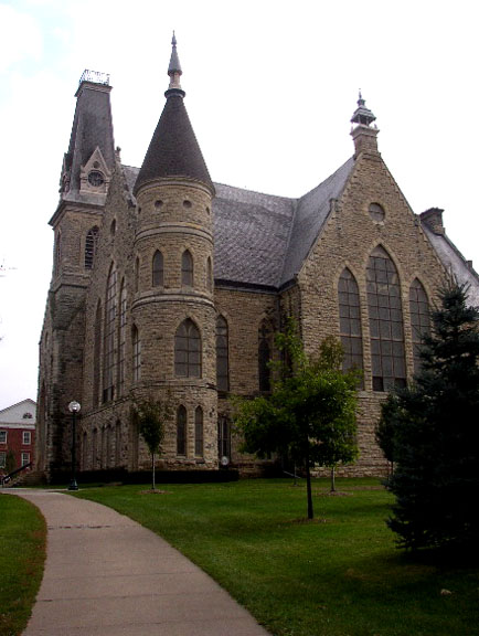
41°58′58″N 91°39′52″W / 41.982778°N 91.664444°WCedar Rapids Also known as Scottish Rite Temple 19 Cornell College-Mount Vernon Historic District July 18, 1980 Roughly bounded by railroad tracks, College Boulevard, N. 10th, N. 8th, and S. 3rd Aves., and N. 2nd and S. 4th Sts.
41°55′34″N 91°25′29″W / 41.926111°N 91.424722°WMount Vernon 20 William and Sue Damour House January 16, 1997 1844 2nd Ave., SE.
41°59′30″N 91°38′38″W / 41.991667°N 91.643889°WCedar Rapids 21 Dewitt-Harman Archeological Site September 14, 2000 Address Restricted Cedar Rapids 22 George B. Douglas House 
September 9, 1982 800 2nd Ave., SE.
41°58′56″N 91°39′39″W / 41.982222°N 91.660833°WCedar Rapids 23 Dows Street Historic District November 14, 2003 Dows St. between State and Main Sts.
41°52′23″N 91°35′10″W / 41.873122°N 91.586117°WEly 24 Ely School House September 20, 2006 1570 Rowley St.
41°52′17″N 91°35′05″W / 41.871389°N 91.584722°WEly 25 Evans Manufacturing Company Building April 15, 1999 301 6th Ave., SE.
41°58′32″N 91°39′46″W / 41.975556°N 91.662778°WCedar Rapids 26 First Avenue Bridge May 15, 1998 U.S. Route 151 over the Cedar River
41°58′36″N 91°40′20″W / 41.976667°N 91.672222°WCedar Rapids 27 First Presbyterian Church of Marion, Iowa July 24, 1992 802 12th St.
42°02′03″N 91°35′50″W / 42.034167°N 91.597222°WMarion 28 First Universalist Church of Cedar Rapids 
August 24, 1978 600 3rd Ave., SE.
41°58′48″N 91°39′44″W / 41.98°N 91.662222°WCedar Rapids Demolished in 2011.[5] 29 Granger House August 13, 1976 970 10th St.
42°02′09″N 91°35′59″W / 42.035833°N 91.599722°WMarion 30 Grant Wood's "Fall Plowing" Rural Historic Landscape District May 30, 2003 0.5 miles north of the junction of Matsell Ln. and Stone City Rd.
42°06′55″N 91°23′20″W / 42.115278°N 91.388889°WViola 31 Douglas and Charlotte Grant House November 9, 1988 3400 Adel St., SE.
42°00′42″N 91°37′20″W / 42.011667°N 91.622222°WMarion 32 Hamilton Brothers Building September 8, 1994 401 1st St., SE.
41°58′30″N 91°40′02″W / 41.975°N 91.667222°WCedar Rapids 33 Highwater Rock November 17, 1977 Cedar River near 1st Ave. and 1st St., NE.
41°58′43″N 91°40′19″W / 41.978611°N 91.671944°WCedar Rapids 34 Henek and Mary Horecky Log Cabin September 14, 2000 Address Restricted Mt. Vernon 35 Hotel Roosevelt 
May 1, 1991 200 1st Ave., NE.
41°58′45″N 91°40′06″W / 41.979167°N 91.668333°WCedar Rapids 36 IANR Railroad Underpass 
May 15, 1998 Ely Rd.
41°56′40″N 91°38′12″W / 41.944444°N 91.636667°WCedar Rapids 37 Indian Creek Bridge May 15, 1998 Artesian Rd. over Indian Creek
41°58′02″N 91°34′52″W / 41.967222°N 91.581111°WCedar Rapids 38 Iowa Building February 17, 1983 221 4th Ave., SE.
41°58′36″N 91°39′53″W / 41.976667°N 91.664722°WCedar Rapids 39 Jan F. and Antonie Janko Farmstead District September 14, 2000 4021 Vista Rd.
41°52′25″N 91°36′18″W / 41.873611°N 91.605°WEly 40 King Memorial Chapel 
November 7, 1976 Cornell College campus
41°55′30″N 91°25′25″W / 41.925°N 91.423611°WMount Vernon 41 Samuel M. Lane House September 14, 2002 1776 8th Ave.
42°02′03″N 91°35′31″W / 42.034167°N 91.591944°WMarion 42 Lattner Auditorium Building 
February 17, 1983 217 4th Ave., SE.
41°58′35″N 91°39′55″W / 41.976389°N 91.665278°WCedar Rapids 43 Lesinger Block December 24, 1997 1317 3rd St., SE.
41°57′46″N 91°39′34″W / 41.962778°N 91.659444°WCedar Rapids 44 Lustron Home No. 02102 
August 25, 2004 2009 Williams Boulevard, SW.
41°58′15″N 91°42′03″W / 41.970833°N 91.700833°WCedar Rapids 45 Marion Carnegie Public Library March 25, 1994 1298 7th Ave.
42°02′00″N 91°35′45″W / 42.033333°N 91.595833°WMarion 46 Marion Commercial Historic District 
November 18, 2009 560-748 10th St., 958-1298 7th Ave., 760-96 11th St., 766-76 13th St., 1108 8th Ave., and 969 6th Ave.
42°02′00″N 91°35′58″W / 42.033358°N 91.599314°WMarion 47 Matsell Bridge May 15, 1998 Natsell Park Rd. over the Wapsipinicon River
42°07′49″N 91°23′01″W / 42.130278°N 91.383611°WSpringville 48 May's Island Historic District 
October 19, 1978 Between 1st and 5th Aves. on May Island
41°58′54″N 91°40′10″W / 41.981667°N 91.669444°WCedar Rapids 49 Joseph P. Mentzer House April 12, 1982 2233 3rd Ave.
42°01′49″N 91°35′26″W / 42.030278°N 91.590556°WMarion 50 Josias L. and Elizabeth A. Minor Farmstead District September 14, 2000 7500 Ely Rd.
41°54′19″N 91°36′51″W / 41.905278°N 91.614167°WEly 51 Joseph and Clara Amanda H. Moorhead House September 14, 2000 88 Palisades Access Rd.
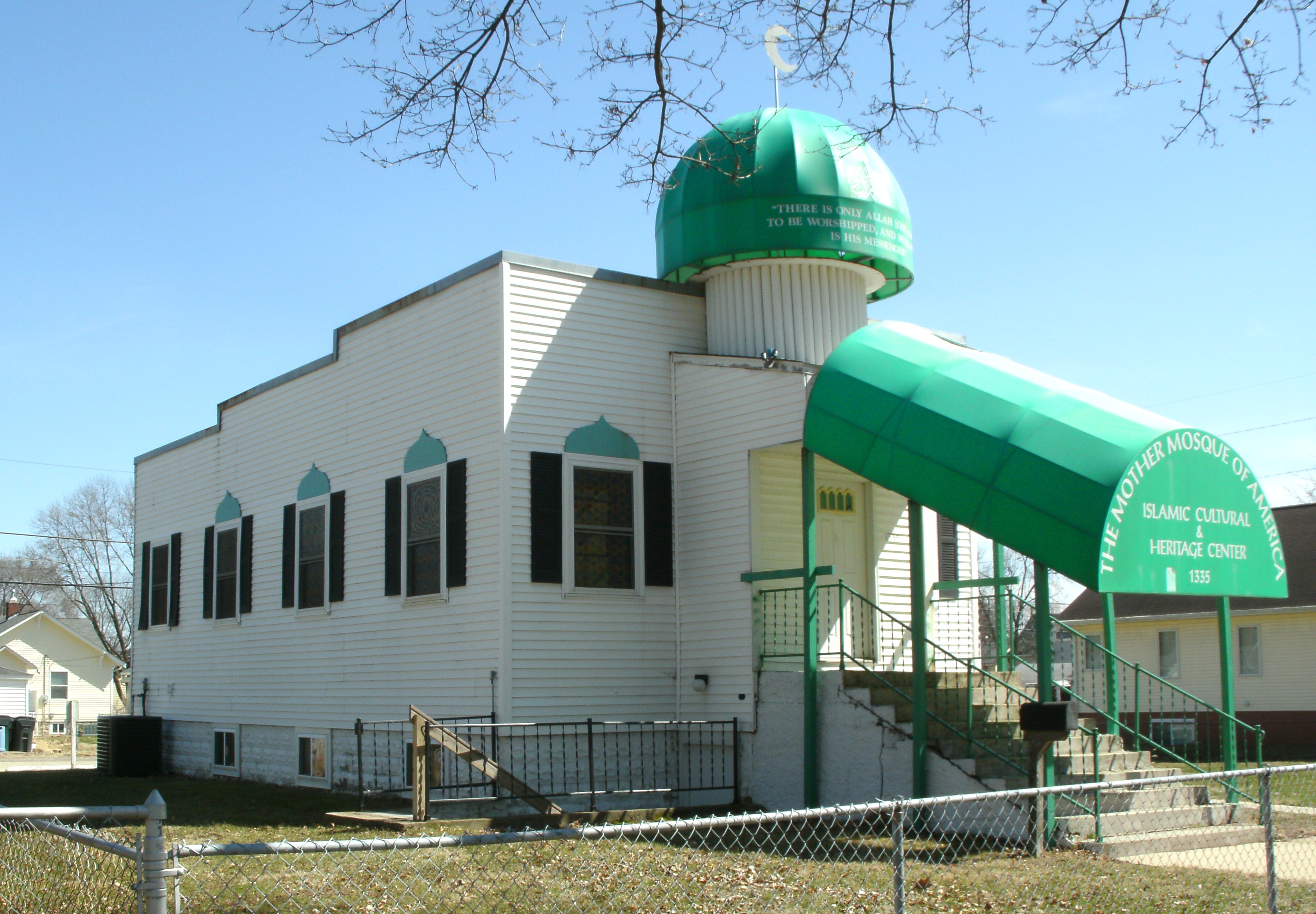
41°51′59″N 91°32′08″W / 41.866389°N 91.535556°WEly 52 Mosque Temple 
May 15, 1996 1335 9th St., NW.
41°59′11″N 91°41′02″W / 41.986389°N 91.683889°WCedar Rapids 53 Mount Vernon Commercial Historic District September 13, 1993 1st St. between 2nd and 1st Aves., N.
41°55′20″N 91°25′01″W / 41.922222°N 91.416944°WMount Vernon 54 Notbohm Mill Archaeological District March 29, 2000 Address Restricted Alburnett 55 Odd Fellows Hall October 10, 1985 Troy Mills Rd.
42°17′20″N 91°40′57″W / 42.288889°N 91.6825°WTroy Mills 56 Paramount Theater Building 
August 26, 1976 121-127 3rd Ave., SE.
41°58′36″N 91°40′00″W / 41.976667°N 91.666667°WCedar Rapids 57 People's Savings Bank 
March 29, 1978 101 3rd Ave., SW.
41°58′28″N 91°40′18″W / 41.974444°N 91.671667°WCedar Rapids 58 Charles W. and Nellie Perkins House 
May 9, 2002 1228 3rd Ave., SE.
41°59′02″N 91°39′18″W / 41.983889°N 91.655°WCedar Rapids 59 Podhajsky-Jansa Farmstead District September 14, 2000 Hoosier Creek Rd.
41°51′41″N 91°36′30″W / 41.861389°N 91.608333°WEly 60 Pucker Street Historic District September 14, 2002 Bounded by 13th St., 9th Ave., 20th St., and 8th Ave.
42°02′03″N 91°35′34″W / 42.034167°N 91.592778°WMarion 61 Glenn O. and Lucy O. Pyle House September 14, 2002 1540 8th Ave.
42°02′03″N 91°35′35″W / 42.034167°N 91.593056°WMarion 62 Redmond Park-Grande Avenue Historic District September 10, 2001 Roughly bounded by U.S. Route 151, 19th St., and Washington Ave.
41°59′16″N 91°38′42″W / 41.987778°N 91.645°WCedar Rapids 63 St. Paul Methodist Episcopal Church 
June 27, 1985 1340 3rd Ave., SE.
41°59′08″N 91°39′10″W / 41.985556°N 91.652778°WCedar Rapids 64 Second and Third Avenue Historic District August 10, 2000 1400 to 1800 blocks of 2nd Ave., SE. and 3rd Ave., SE.
41°59′14″N 91°38′12″W / 41.987222°N 91.636667°WCedar Rapids 65 Security Building December 7, 1977 2nd Ave. and 2nd St., SE
41°58′40″N 91°40′03″W / 41.977778°N 91.6675°WCedar Rapids 66 Seminole Valley Farmstead October 8, 1976 West of Cedar Rapids
42°00′13″N 91°43′38″W / 42.003611°N 91.727222°WCedar Rapids 67 T.M. Sinclair Mansion 
December 12, 1976 2160 Linden Dr., SE.
41°59′31″N 91°38′19″W / 41.991944°N 91.638611°WCedar Rapids 68 Harrison Stuckslager House October 1, 1979 207 N. Jackson St.
41°55′25″N 91°23′05″W / 41.923611°N 91.384722°WLisbon 69 Taylor-Van Note October 10, 1985 4600 Blairs Ferry Rd.
42°02′31″N 91°43′42″W / 42.041944°N 91.728333°WCedar Rapids 70 Terrace Park Historic District October 25, 2006 Roughly bounded by 10th Ave., 9th Ave., 11th St., and the eastern side of 12th St.
42°02′15″N 91°35′50″W / 42.0375°N 91.597222°WMarion 71 Torrance House July 7, 1983 South of Lisbon
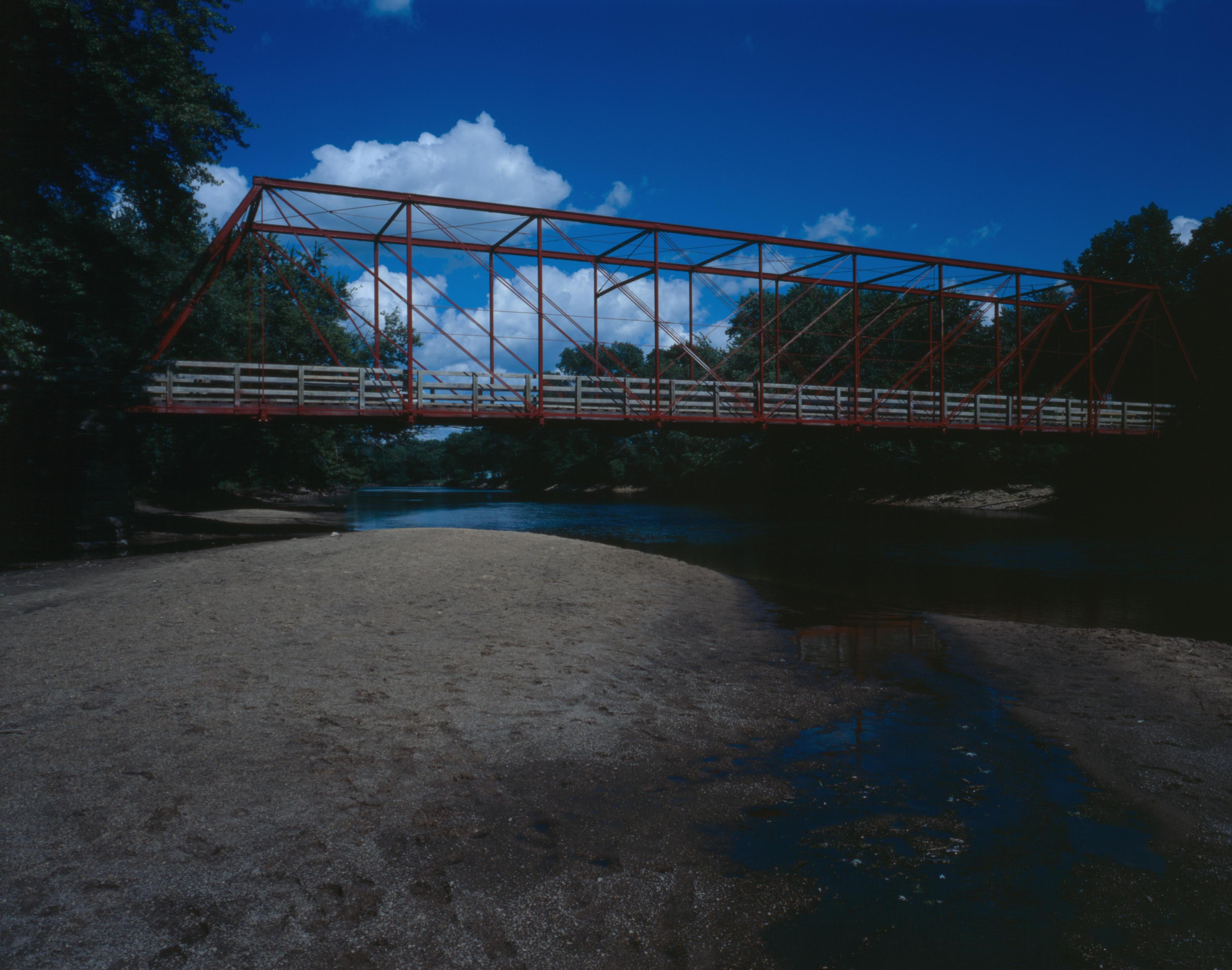
41°53′44″N 91°23′48″W / 41.895556°N 91.396667°WLisbon 72 Upper Paris Bridge 
May 15, 1998 Sutton Rd. over the Wapsipinicon River
42°14′40″N 91°35′04″W / 42.244444°N 91.584444°WCoggin 73 Wesley West House June 27, 1985 Palisades Rd.
41°55′04″N 91°25′43″W / 41.917778°N 91.428611°WMount Vernon 74 Whittier Friends Meeting House None Junction of County Roads E34 and X20
42°05′35″N 91°27′50″W / 42.093056°N 91.463889°WWhittier 75 Witwer Grocery Company Building May 1, 1998 905 3rd St., SE.
41°58′21″N 91°39′38″W / 41.9725°N 91.660556°WCedar Rapids 76 Philip A. Wolff House and Carriage House October 7, 1982 1420 Seminole Ave., NW.
41°58′43″N 91°41′30″W / 41.978611°N 91.691667°WCedar Rapids See also
References
- ^ The latitude and longitude information provided in this table was derived originally from the National Register Information System, which has been found to be fairly accurate for about 99% of listings. For about 1% of NRIS original coordinates, experience has shown that one or both coordinates are typos or otherwise extremely far off; some corrections may have been made. A more subtle problem causes many locations to be off by up to 150 yards, depending on location in the country: most NRIS coordinates were derived from tracing out latitude and longitudes off of USGS topographical quadrant maps created under North American Datum of 1927, which differs from the current, highly accurate GPS system used by Google maps. Chicago is about right, but NRIS longitudes in Washington are higher by about 4.5 seconds, and are lower by about 2.0 seconds in Maine. Latitudes differ by about 1.0 second in Florida. Some locations in this table may have been corrected to current GPS standards.
- ^ "National Register of Historic Places: Weekly List Actions". National Park Service, United States Department of the Interior. Retrieved on November 10, 2011.
- ^ Numbers represent an ordering by significant words. Various colorings, defined here, differentiate National Historic Landmark sites and National Register of Historic Places Districts from other NRHP buildings, structures, sites or objects.
- ^ "National Register Information System". National Register of Historic Places. National Park Service. . http://nrhp.focus.nps.gov/natreg/docs/All_Data.html.
- ^ http://www.kcrg.com/news/local/Peoples-Church-Building-Demolished-Because-of-Mold-and-Structural-Problems-132501683.html
U.S. National Register of Historic Places Topics Lists by states Alabama • Alaska • Arizona • Arkansas • California • Colorado • Connecticut • Delaware • Florida • Georgia • Hawaii • Idaho • Illinois • Indiana • Iowa • Kansas • Kentucky • Louisiana • Maine • Maryland • Massachusetts • Michigan • Minnesota • Mississippi • Missouri • Montana • Nebraska • Nevada • New Hampshire • New Jersey • New Mexico • New York • North Carolina • North Dakota • Ohio • Oklahoma • Oregon • Pennsylvania • Rhode Island • South Carolina • South Dakota • Tennessee • Texas • Utah • Vermont • Virginia • Washington • West Virginia • Wisconsin • WyomingLists by territories Lists by associated states Other  Category:National Register of Historic Places •
  Portal:National Register of Historic Places
Municipalities and communities of Linn County, Iowa County seat: Cedar Rapids Cities Alburnett | Bertram | Cedar Rapids | Center Point | Central City | Coggon | Ely | Fairfax | Hiawatha | Lisbon | Marion | Mount Vernon | Palo | Prairieburg | Robins | Springville | Walford‡ | Walker

Unincorporated
communitiesParis | Toddville | Troy Mills | Viola | Waubeek | Whittier
Footnotes ‡This populated place also has portions in an adjacent county or counties
Categories:- National Register of Historic Places in Iowa by county
- Linn County, Iowa
- Buildings and structures in Linn County, Iowa
-


Wikimedia Foundation. 2010.