- National Register of Historic Places listings in Marion County, Iowa
-
 Location of Marion County in Iowa
This is a list of the National Register of Historic Places listings in Marion County, Iowa.
This is intended to be a complete list of the properties and districts on the National Register of Historic Places in Marion County, Iowa, United States. Latitude and longitude coordinates are provided for many National Register properties and districts; these locations may be seen together in a Google map.[1]
There are 24 properties and districts listed on the National Register in the county.
-
- This National Park Service list is complete through NPS recent listings posted November 10, 2011.[2]
Current listings
[3] Landmark name [4] Image Date listed Location City or town Summary 1 Chicago, Rock Island and Pacific Passenger Depot-Pella July 22, 1991 Junction of Main and Oskaloosa Sts.
41°23′54″N 92°54′54″W / 41.398333°N 92.915°WPella 2 Coal Ridge Baptist Church and Cemetery August 23, 2006 1034 Iowa Highway 71
41°22′41″N 93°01′15″W / 41.378056°N 93.020833°WKnoxville 3 East Amsterman School December 1, 2000 1010 198th Place
41°23′06″N 92°57′28″W / 41.385°N 92.957778°WPella 4 Evan F. Ellis Farmhouse January 3, 1985 Junction of Story and West Sts.
41°13′10″N 92°53′20″W / 41.219444°N 92.888889°WBussey 5 First Christian Church March 29, 2007 824 Franklin St.
41°24′26″N 92°55′09″W / 41.407222°N 92.919167°WPella 6 Hammond Bridge May 15, 1998 170th Pl. over North Cedar Creek
41°10′39″N 93°00′50″W / 41.1775°N 93.013889°WHamilton 7 Harvey Railroad Bridge May 15, 1998 Harvey Island Rd.
41°19′02″N 92°54′36″W / 41.317222°N 92.91°WHarvey 8 E.R. Hays House September 27, 1984 301 N. 2nd St.
41°19′16″N 93°05′49″W / 41.321111°N 93.096944°WKnoxville 9 Knoxville WPA Athletic Field Historic District August 2, 2007 Bounded by Lincoln St., Robinson St., Stadium St., and Marion St.
41°19′08″N 93°06′31″W / 41.318761°N 93.108617°WKnoxville 10 Philipus J. and Cornelia Koelman House December 21, 2005 1005 Broadway St.
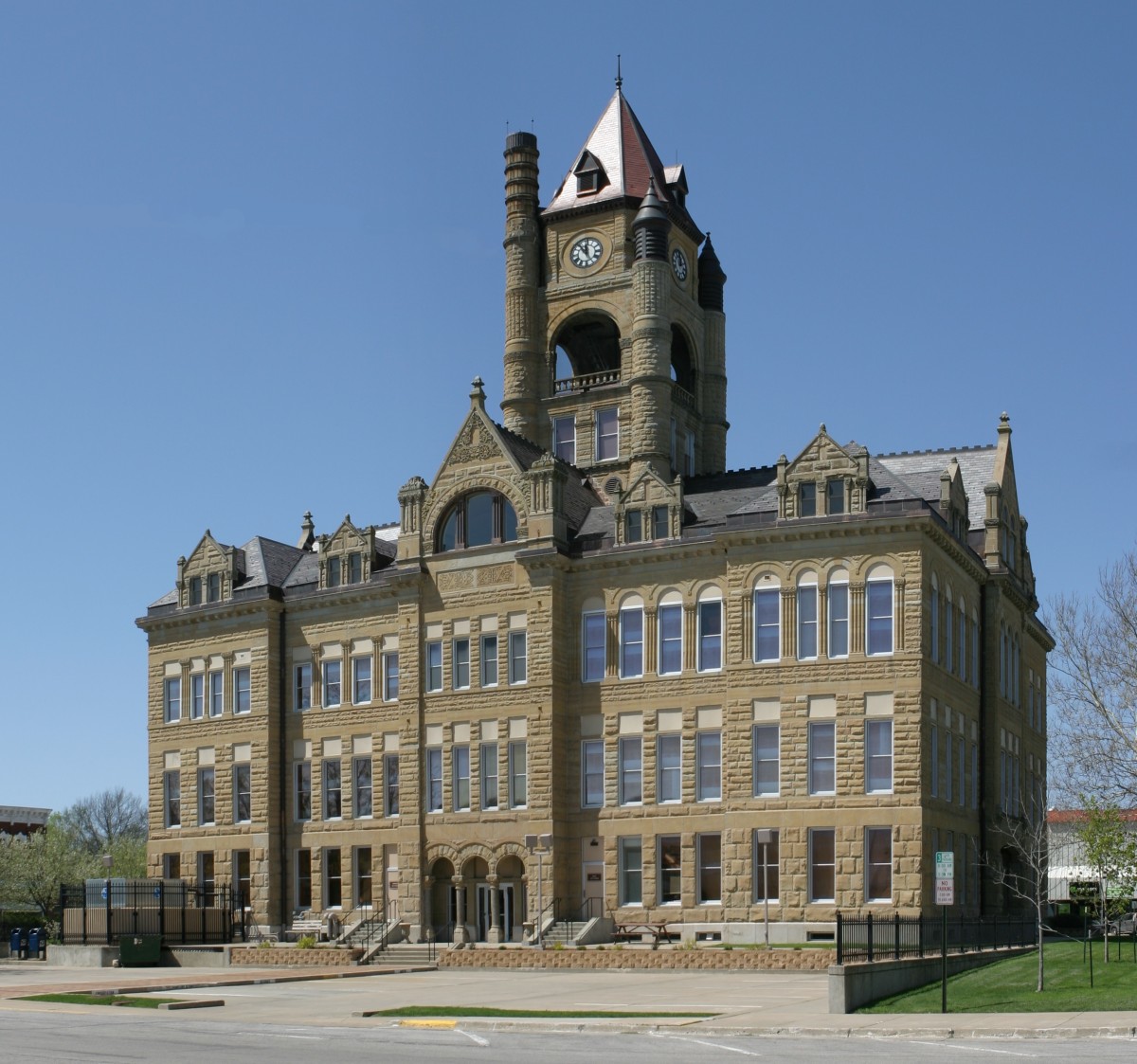
41°24′35″N 92°55′06″W / 41.409722°N 92.918333°WPella 11 Marion County Courthouse 
July 2, 1981 Main St.
41°19′06″N 93°05′48″W / 41.318333°N 93.096667°WKnoxville 12 Pella Opera House March 20, 1992 611 Franklin St.
41°24′23″N 92°54′51″W / 41.406389°N 92.914167°WPella 13 People's National Bank April 21, 2010 717 Main St.
41°24′20″N 92°54′59″W / 41.405633°N 92.916478°WPella 14 Porter-Rhynsburger House August 28, 2003 514 Broadway St.
41°24′14″N 92°55′06″W / 41.403889°N 92.918333°WPella 15 St. Joseph's Roman Catholic Church and Cemetery Historic District January 24, 1995 1 mile east of the junction of County Road G76 and SE. 97th St.
41°12′12″N 93°18′29″W / 41.203333°N 93.308056°WLacona 16 Dominie Henry P. Scholte House December 10, 1982 739 Washington St.
41°24′30″N 92°55′02″W / 41.408333°N 92.917222°WPella 17 Ten Hagen Cottage-Stegman Store July 16, 2008 1110 W. Washington St.
41°24′29″N 92°55′25″W / 41.40812°N 92.92371°WPella 18 William Van Asch House-Huibert Debooy Commercial Room 
December 2, 1987 1105, 1107, and 1109 W. Washington St.
41°24′28″N 92°55′27″W / 41.407778°N 92.924167°WPella 19 Hendrik J. and Wilhelmina H. Van Den Berg Cottage August 28, 2003 1305 W. Washington St.
41°24′14″N 92°55′42″W / 41.403889°N 92.928333°WPella 20 Dirk Van Loon House November 17, 1977 1401 University Ave.
41°24′02″N 92°55′33″W / 41.400556°N 92.925833°WPella 21 Henry and Johanna Van Maren House-Diamond Filling Station July 10, 2008 615 Main St.
41°24′15″N 92°54′59″W / 41.40428°N 92.91652°WPella 22 B.H. and J.H.H. Van Spanckeren Row Houses 
February 12, 1990 505-507 Franklin St.
41°24′08″N 92°54′30″W / 41.402222°N 92.908333°WPella 23 Dirk and Cornelia J. Vander Wilt Cottage August 8, 2001 925 Broadway St.
41°24′32″N 92°55′06″W / 41.408889°N 92.918333°WPella 24 Wabash Railroad Bridge May 15, 1998 216th Pl. over the Des Moines River
41°20′26″N 92°56′25″W / 41.340556°N 92.940278°WPella See also
References
- ^ The latitude and longitude information provided in this table was derived originally from the National Register Information System, which has been found to be fairly accurate for about 99% of listings. For about 1% of NRIS original coordinates, experience has shown that one or both coordinates are typos or otherwise extremely far off; some corrections may have been made. A more subtle problem causes many locations to be off by up to 150 yards, depending on location in the country: most NRIS coordinates were derived from tracing out latitude and longitudes off of USGS topographical quadrant maps created under the North American Datum of 1927, which differs from the current, highly accurate WGS84 GPS system used by Google maps. Chicago is about right, but NRIS longitudes in Washington are higher by about 4.5 seconds, and are lower by about 2.0 seconds in Maine. Latitudes differ by about 1.0 second in Florida. Some locations in this table may have been corrected to current GPS standards.
- ^ "National Register of Historic Places: Weekly List Actions". National Park Service, United States Department of the Interior. Retrieved on November 10, 2011.
- ^ Numbers represent an ordering by significant words. Various colorings, defined here, differentiate National Historic Landmark sites and National Register of Historic Places Districts from other NRHP buildings, structures, sites or objects.
- ^ "National Register Information System". National Register of Historic Places. National Park Service. . http://nrhp.focus.nps.gov/natreg/docs/All_Data.html.
U.S. National Register of Historic Places Topics Lists by states Alabama • Alaska • Arizona • Arkansas • California • Colorado • Connecticut • Delaware • Florida • Georgia • Hawaii • Idaho • Illinois • Indiana • Iowa • Kansas • Kentucky • Louisiana • Maine • Maryland • Massachusetts • Michigan • Minnesota • Mississippi • Missouri • Montana • Nebraska • Nevada • New Hampshire • New Jersey • New Mexico • New York • North Carolina • North Dakota • Ohio • Oklahoma • Oregon • Pennsylvania • Rhode Island • South Carolina • South Dakota • Tennessee • Texas • Utah • Vermont • Virginia • Washington • West Virginia • Wisconsin • WyomingLists by territories Lists by associated states Other Municipalities and communities of Marion County, Iowa Cities Bussey | Hamilton | Harvey | Knoxville | Marysville | Melcher-Dallas | Pella | Pleasantville | Swan

Unincorporated
communitiesCategories:- National Register of Historic Places in Iowa by county
- Marion County, Iowa
- Buildings and structures in Marion County, Iowa
-


Wikimedia Foundation. 2010.