- National Register of Historic Places listings in Franklin County, Iowa
-
 Location of Franklin County in Iowa
This is a list of the National Register of Historic Places listings in Franklin County, Iowa.
This is intended to be a complete list of the properties and districts on the National Register of Historic Places in Franklin County, Iowa, United States. Latitude and longitude coordinates are provided for many National Register properties and districts; these locations may be seen together in a Google map.[1]
There are 11 properties and districts listed on the National Register in the county.
-
- This National Park Service list is complete through NPS recent listings posted November 10, 2011.[2]
[3] Landmark name [4] Image Date listed Location City or town Summary 1 Beeds Lake State Park, Civilian Conservation Corps Area November 15, 1990 Junction of Iowa Highways 3 and 134
42°46′15″N 93°14′21″W / 42.770833°N 93.239167°WHampton 2 H.E. Boehmler House December 13, 1991 105 2nd St., SE.
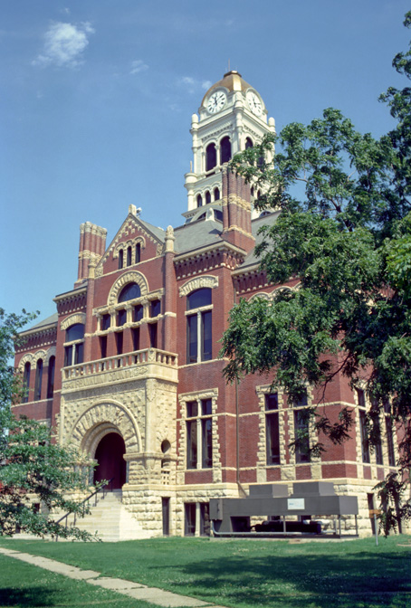
42°44′26″N 93°12′18″W / 42.740556°N 93.205°WHampton 3 Franklin County Courthouse 
August 13, 1976 Central Ave. and 1st St., NW.
42°44′29″N 93°12′32″W / 42.741389°N 93.208889°WHampton 4 Franklin County G. A. R. Soldiers' Memorial Hall December 13, 1991 3 Federal St., N.
42°44′29″N 93°12′25″W / 42.741389°N 93.206944°WHampton 5 Franklin County Sheriff's Residence and Jail August 16, 1996 18 E. Central Ave.
42°44′31″N 93°12′23″W / 42.741944°N 93.206389°WHampton 6 Hampton Double Square Historic District August 28, 2003 Roughly bounded by 2nd Ave., 1st Ave., the alley west of 1st St., and the alley east of Federal
42°44′31″N 93°12′28″W / 42.741944°N 93.207778°WHampton 7 Dr. O.B. Harriman House February 5, 1987 26 10th St., NW.
42°44′31″N 93°13′14″W / 42.741944°N 93.220556°WHampton 8 Maysville Schoolhouse June 17, 1981 South of Hampton
42°40′00″N 93°12′11″W / 42.666667°N 93.203056°WHampton 9 Reeve Electric Association Plant April 6, 1990 Rural Route 1 southwest of Hampton
42°41′14″N 93°13′58″W / 42.687222°N 93.232778°WHampton 10 Leander Reeve House July 17, 1979 Southeast of Hampton on Iowa Highway 134
42°40′36″N 93°09′49″W / 42.676667°N 93.163611°WHampton 11 Herman Wood Round Barn June 30, 1986 U.S. Route 65
42°33′28″N 93°15′02″W / 42.557778°N 93.250556°WIowa Falls See also
References
- ^ The latitude and longitude information provided in this table was derived originally from the National Register Information System, which has been found to be fairly accurate for about 99% of listings. For about 1% of NRIS original coordinates, experience has shown that one or both coordinates are typos or otherwise extremely far off; some corrections may have been made. A more subtle problem causes many locations to be off by up to 150 yards, depending on location in the country: most NRIS coordinates were derived from tracing out latitude and longitudes off of USGS topographical quadrant maps created under the North American Datum of 1927, which differs from the current, highly accurate WGS84 GPS system used by Google maps. Chicago is about right, but NRIS longitudes in Washington are higher by about 4.5 seconds, and are lower by about 2.0 seconds in Maine. Latitudes differ by about 1.0 second in Florida. Some locations in this table may have been corrected to current GPS standards.
- ^ "National Register of Historic Places: Weekly List Actions". National Park Service, United States Department of the Interior. Retrieved on November 10, 2011.
- ^ Numbers represent an ordering by significant words. Various colorings, defined here, differentiate National Historic Landmark sites and National Register of Historic Places Districts from other NRHP buildings, structures, sites or objects.
- ^ "National Register Information System". National Register of Historic Places. National Park Service. . http://nrhp.focus.nps.gov/natreg/docs/All_Data.html.
U.S. National Register of Historic Places Topics Lists by states Alabama • Alaska • Arizona • Arkansas • California • Colorado • Connecticut • Delaware • Florida • Georgia • Hawaii • Idaho • Illinois • Indiana • Iowa • Kansas • Kentucky • Louisiana • Maine • Maryland • Massachusetts • Michigan • Minnesota • Mississippi • Missouri • Montana • Nebraska • Nevada • New Hampshire • New Jersey • New Mexico • New York • North Carolina • North Dakota • Ohio • Oklahoma • Oregon • Pennsylvania • Rhode Island • South Carolina • South Dakota • Tennessee • Texas • Utah • Vermont • Virginia • Washington • West Virginia • Wisconsin • WyomingLists by territories Lists by associated states Other Municipalities and communities of Franklin County, Iowa Cities 
Unincorporated
communitiesFootnotes ‡This populated place also has portions in an adjacent county or counties
Categories:- National Register of Historic Places in Iowa by county
- Franklin County, Iowa
- Buildings and structures in Franklin County, Iowa
-


Wikimedia Foundation. 2010.