- National Register of Historic Places listings in Franklin County, Kansas
-
 Location of Franklin County in Kansas
This is a list of the National Register of Historic Places listings in Franklin County, Kansas.
This is intended to be a complete list of the properties and districts on the National Register of Historic Places in Franklin County, Kansas, United States. The locations of National Register properties and districts for which the latitude and longitude coordinates are included below, may be seen in a Google map.[1]
There are 18 properties and districts listed on the National Register in the county.
-
- This National Park Service list is complete through NPS recent listings posted November 10, 2011.[2]
Current listings
[3] Landmark name [4] Image Date listed Location City or town Summary 1 Dietrich Cabin February 23, 1972 Ottawa City Park
38°36′39″N 95°16′03″W / 38.610833°N 95.2675°WOttawa 2 Downtown Ottawa Historic District June 29, 1972 East side of S. Main St. from No. 135 to 3rd St.
38°36′54″N 95°16′05″W / 38.615°N 95.268056°WOttawa 3 Eight Mile Creek Warren Truss Bridge 
May 9, 2003 Osborne Terrace, 0.2 miles west of intersection with Eisenhower Terrace, 1.0 mile west of Main St.
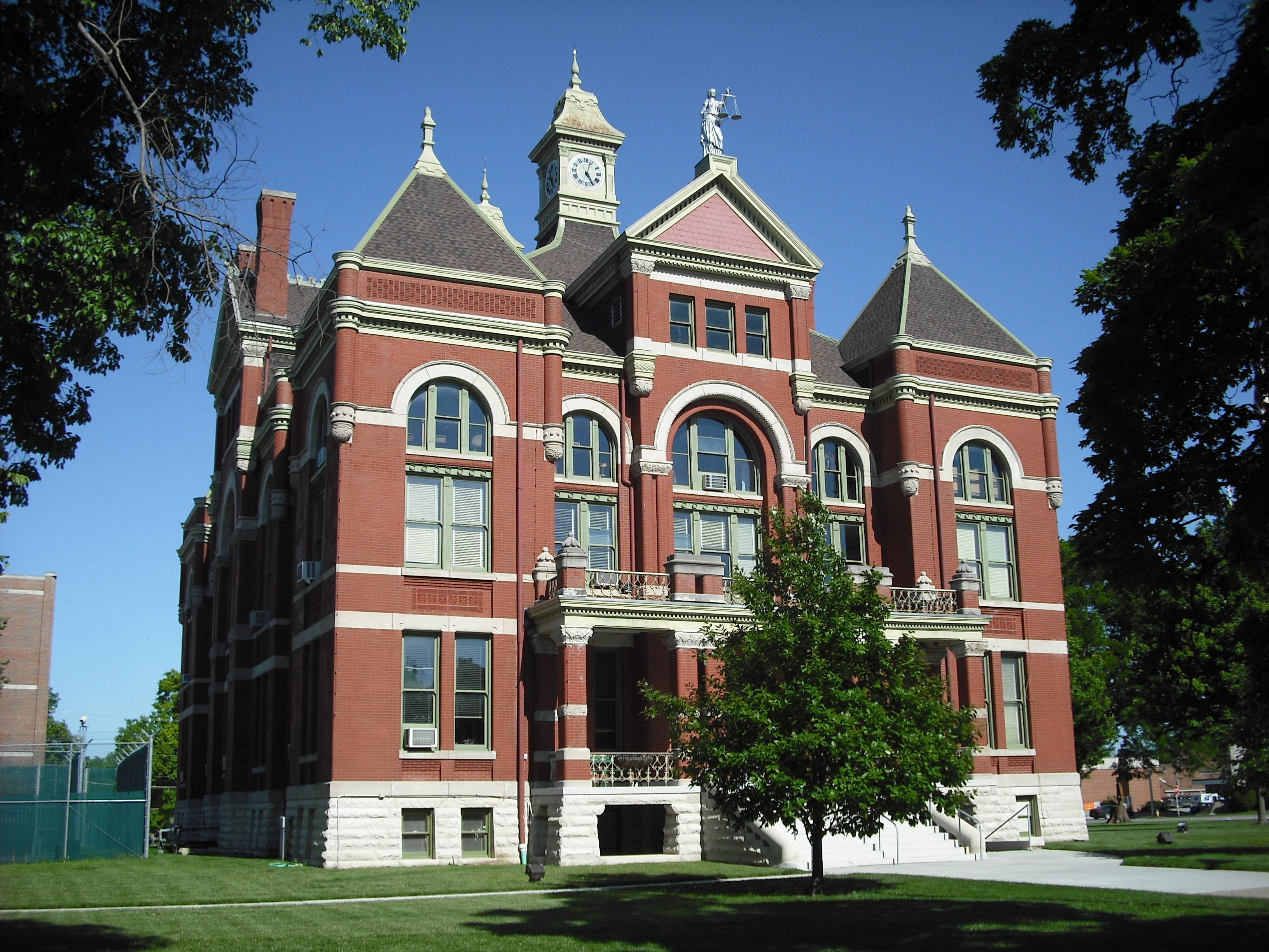
38°37′52″N 95°17′08″W / 38.631111°N 95.285556°WOttawa 4 Franklin County Courthouse 
March 17, 1972 Main St.
38°36′48″N 95°16′03″W / 38.613333°N 95.2675°WOttawa 5 Judge James Hanway House December 11, 2008 658 Virginia Rd.
38°25′52″N 95°05′03″W / 38.431111°N 95.084167°WLane 6 Historic Ottawa Central Business District February 7, 2008 Roughly bounded by Marias des Cygnes River, S. 5th St., Walnut St., and Hickory St. Ottawa 7 Tauy Jones Hall 
June 14, 1982 Ottawa University campus, 10th and Cedar Sts.
38°36′14″N 95°15′47″W / 38.603889°N 95.263056°WOttawa 8 Tauy Jones House 
June 19, 1972 3 miles northeast of Ottawa on Tauy Creek
38°39′51″N 95°13′14″W / 38.664167°N 95.220556°WOttawa 9 Middle Creek Tributary Bridge July 2, 1985 5.8 miles west of Princeton
38°29′32″N 95°22′33″W / 38.492222°N 95.375833°WPrinceton 10 Old Santa Fe Railroad Depot 
March 1, 1973 135 W. Tecumseh St.
38°37′14″N 95°16′09″W / 38.620556°N 95.269167°WOttawa 11 Ottawa High School and Junior High School October 6, 2000 526 and 506 S. Main St.
38°36′37″N 95°16′07″W / 38.610278°N 95.268611°WOttawa 12 Ottawa Library December 1, 1980 5th and Main Sts.
38°36′15″N 95°15′43″W / 38.604167°N 95.261944°WOttawa 13 Pleasant Valley School District #2 February 26, 2004 2905 Thomas Rd.
38°43′27″N 95°08′48″W / 38.724167°N 95.146667°WWellsville 14 James H. Ransom House November 21, 1974 318 S. Locust St.
38°36′49″N 95°16′17″W / 38.613611°N 95.271389°WOttawa 15 Silkville 
December 15, 1972 2.5 miles southwest of Williamsburg on U.S. Route 50
38°26′25″N 95°29′13″W / 38.440278°N 95.486944°WWilliamsburg 16 Tauy Creek Bridge 
October 25, 1990 Over Tauy Creek, north of Interstate 35
38°39′53″N 95°13′23″W / 38.664722°N 95.223056°WOttawa 17 Walnut Creek Bridge 
July 2, 1985 Off K-33, 1 mile south of Wellsville
38°41′18″N 95°05′05″W / 38.688333°N 95.084722°WWellsville 18 Wellsville Bank Building October 24, 1991 418 Main St.
38°43′08″N 95°04′55″W / 38.718889°N 95.081944°WWellsville See also
- List of National Historic Landmarks in Kansas
- National Register of Historic Places listings in Kansas
References
- ^ The latitude and longitude information provided in this table was derived originally from the National Register Information System, which has been found to be fairly accurate for about 99% of listings. For about 1% of NRIS original coordinates, experience has shown that one or both coordinates are typos or otherwise extremely far off; some corrections may have been made. A more subtle problem causes many locations to be off by up to 150 yards, depending on location in the country: most NRIS coordinates were derived from tracing out latitude and longitudes off of USGS topographical quadrant maps created under the North American Datum of 1927, which differs from the current, highly accurate WGS84 GPS system used by Google maps. Chicago is about right, but NRIS longitudes in Washington are higher by about 4.5 seconds, and are lower by about 2.0 seconds in Maine. Latitudes differ by about 1.0 second in Florida. Some locations in this table may have been corrected to current GPS standards.
- ^ "National Register of Historic Places: Weekly List Actions". National Park Service, United States Department of the Interior. Retrieved on November 10, 2011.
- ^ Numbers represent an ordering by significant words. Various colorings, defined here, differentiate National Historic Landmark sites and National Register of Historic Places Districts from other NRHP buildings, structures, sites or objects.
- ^ "National Register Information System". National Register of Historic Places. National Park Service. . http://nrhp.focus.nps.gov/natreg/docs/All_Data.html.
Municipalities and communities of Franklin County, Kansas Cities Lane | Ottawa | Pomona | Princeton | Rantoul | Richmond | Wellsville | Williamsburg
Townships Unincorporated
communitiesCentropolis | Homewood | Imes | LeLoup | Norwood | Peoria | Ransomville | Richter
Ghost town Silkville
Categories:- Franklin County, Kansas
- National Register of Historic Places in Kansas by county
- Buildings and structures in Franklin County, Kansas
-


Wikimedia Foundation. 2010.