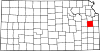
- Ohio Township, Franklin County, Kansas
-
Ohio Township — Township — Location in Franklin County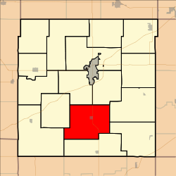
Coordinates: 38°28′40″N 095°17′41″W / 38.47778°N 95.29472°WCoordinates: 38°28′40″N 095°17′41″W / 38.47778°N 95.29472°W Country United States State Kansas County Franklin Area – Total 42.04 sq mi (108.88 km2) – Land 41.6 sq mi (107.73 km2) – Water 0.44 sq mi (1.15 km2) 1.06% Elevation 938 ft (286 m) Population (2000) – Total 783 – Density 18.8/sq mi (7.3/km2) GNIS feature ID 0479686 Ohio Township is a township in Franklin County, Kansas, USA. As of the 2000 census, its population was 783.
Contents
Geography
Ohio Township covers an area of 42.04 square miles (108.9 km2) and contains one incorporated settlement, Princeton.
The stream of Payne Creek runs through this township.
Transportation
Ohio Township contains one airport or landing strip, Cochran Airport.
References
External links
Municipalities and communities of Franklin County, Kansas Cities Lane | Ottawa | Pomona | Princeton | Rantoul | Richmond | Wellsville | Williamsburg
Townships Appanoose | Centropolis | Cutler | Franklin | Greenwood | Harrison | Hayes | Homewood | Lincoln | Ohio | Ottawa | Peoria | Pomona | Pottawatomie | Richmond | Williamsburg
Unincorporated
communitiesCentropolis | Homewood | Imes | LeLoup | Norwood | Peoria | Ransomville | Richter
Ghost town Silkville
Categories:- Townships in Franklin County, Kansas
- East-Central Kansas geography stubs


Wikimedia Foundation. 2010.