- National Register of Historic Places listings in Doniphan County, Kansas
-
 Location of Doniphan County in Kansas
This is a list of the National Register of Historic Places listings in Doniphan County, Kansas.
This is intended to be a complete list of the properties and districts on the National Register of Historic Places in Doniphan County, Kansas, United States. The locations of National Register properties and districts for which the latitude and longitude coordinates are included below, may be seen in a Google map.[1]
There are 36 properties and districts listed on the National Register in the county.
-
- This National Park Service list is complete through NPS recent listings posted November 10, 2011.[2]
Current listings
[3] Landmark name [4] Image Date listed Location City or town Summary 1 Albert Albers Barn May 7, 1987 South of Bendena
39°41′13″N 95°10′52″W / 39.686944°N 95.181111°WBendena 2 Nicholas Bohr Barn May 7, 1987 Southeast of Troy
39°43′35″N 95°02′49″W / 39.726389°N 95.046944°WTroy 3 Brenner Vineyards Historic District May 24, 2005 Southwest of the junction of Mineral Point and 95th Rds.
39°38′26″N 95°05′09″W / 39.640556°N 95.085833°WDoniphan 4 Herman Chrystal Barn May 7, 1987 West of Wathena
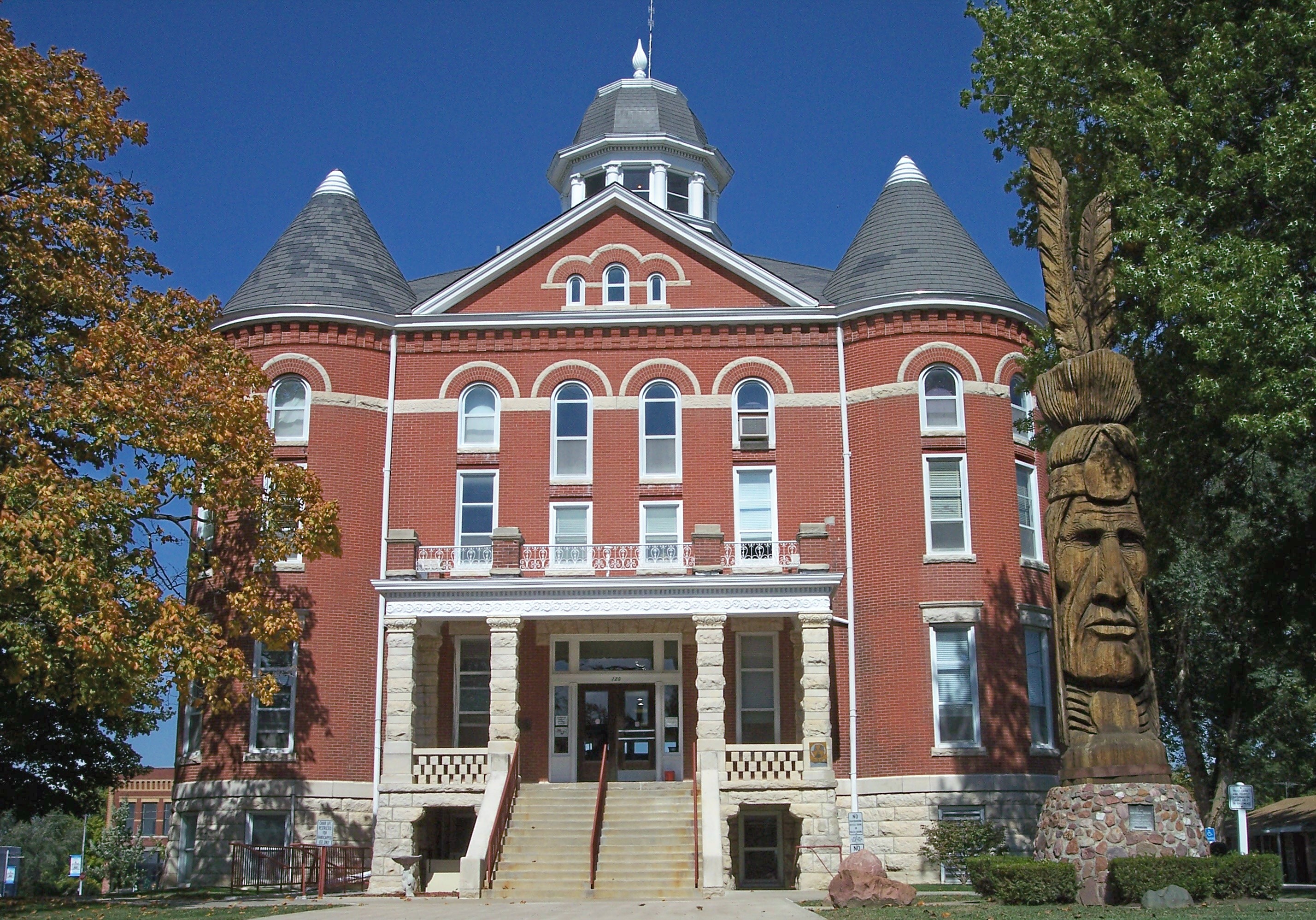
39°44′14″N 95°00′45″W / 39.737222°N 95.0125°WWathena 5 Doniphan Archeological Site March 1, 1974 Address restricted Doniphan 6 Doniphan County Courthouse 
July 15, 1974 Courthouse Sq., bounded by Walnut, Liberty, Chestnut, and Main Sts.
39°47′10″N 95°05′20″W / 39.786111°N 95.088889°WTroy 7 Doniphan County Courthouse Square Historic District 
July 3, 2002 Roughly bounded by E. Walnut, E. Chestnut, S. Main, and S. Liberty Sts.
39°47′10″N 95°05′21″W / 39.786111°N 95.089167°WTroy 8 Doniphan County Waddell January 4, 1990 FAS 28, 1.7 miles northeast of Doniphan
39°38′38″N 95°03′15″W / 39.643889°N 95.054167°WDoniphan 9 Mathew Eylar Barn No. 1 May 7, 1987 South of Denton off K-20
39°39′15″N 95°15′47″W / 39.654167°N 95.263056°WDenton 10 Mathew Eylar Barn No. 2 May 7, 1987 Southeast of Denton off K-20
39°39′47″N 95°14′30″W / 39.663056°N 95.241667°WDenton 11 Fanning Archeological Site June 20, 1972 Address restricted Fanning 12 First National Bank Building July 2, 2008 422-424 W. Main St.
39°51′35″N 95°16′08″W / 39.859722°N 95.268889°WHighland 13 John R. Hale Barn May 7, 1987 K-120
39°48′32″N 95°15′57″W / 39.808889°N 95.265833°WHighland 14 George Hanson Barn May 7, 1987 South of Leona
39°45′58″N 95°19′15″W / 39.766111°N 95.320833°WLeona 15 Highland Christian Church April 4, 2007 102 E. Main St.
39°51′35″N 95°15′53″W / 39.859722°N 95.264722°WHighland 16 Highland Presbyterian Church April 4, 2007 101 South Ave.
39°51′34″N 95°16′15″W / 39.859444°N 95.270833°WHighland 17 Highland Water Tower April 4, 2007 Junction of N. Genesee and W. Illinois Sts.
39°51′37″N 95°16′02″W / 39.860278°N 95.267222°WHighland 18 Iowa, Sac, and Fox Presbyterian Mission December 2, 1970 1.5 miles east of Highland on U.S. Route 36 and 0.2 miles north on K-136
39°51′51″N 95°13′45″W / 39.864167°N 95.229167°WHighland 19 Irvin Hall, Highland Community Junior College 
February 24, 1971 Highland Community Junior College campus
39°51′36″N 95°16′13″W / 39.86°N 95.270278°WHighland 20 Fred W. Kienhoff Barn May 7, 1987 West of Wathena
39°43′34″N 95°02′21″W / 39.726111°N 95.039167°WWathena 21 George Kinkhead Barn May 7, 1987 Off U.S. Route 36
39°47′31″N 95°05′05″W / 39.791944°N 95.084722°WTroy 22 Godfrey Nuzum Barn May 7, 1987 K-7
39°53′31″N 95°12′38″W / 39.891944°N 95.210556°WSparks 23 Poulet House September 3, 1971 Poplar St. between 1st and 2nd Sts.
39°59′00″N 95°17′49″W / 39.983333°N 95.296944°WWhite Cloud 24 St. Benedict's Church April 9, 1998 5 miles southwest of Bendena
39°43′08″N 95°13′52″W / 39.718889°N 95.231111°WBendena 25 St. Martha's AME Church and Parsonage July 20, 2000 Southwestern corner of Main and Canada
39°51′33″N 95°15′41″W / 39.859167°N 95.261389°WHighland 26 St. Mary's Catholic Church April 25, 2001 446 K-137
39°40′54″N 95°19′49″W / 39.681667°N 95.330278°WPurcell 27 John Silvers Barn May 7, 1987 North of Wathena
39°49′56″N 94°57′33″W / 39.832222°N 94.959167°WWathena 28 Site No. RH00-062 
June 19, 1987 6½ miles southeast of Rulo, Nebraska and 200 feet west of the road between White Cloud, Kansas and Rulo
40°00′00″N 95°19′55″W / 40.0°N 95.331944°WIowa Township This site extends into Richardson County, Nebraska 29 John Streib Barn May 7, 1987 North of Leona
39°47′38″N 95°19′13″W / 39.793889°N 95.320278°WLeona 30 J.A. Symns Barn May 7, 1987 K-7
39°40′35″N 95°08′30″W / 39.676389°N 95.141667°WBendena 31 Wathena Fruit Growers' Association Building December 17, 2009 104 3rd St.
39°45′34″N 94°56′52″W / 39.759578°N 94.947656°WWathena 32 T.L. White Barn May 7, 1987 K-7
39°40′31″N 95°08′39″W / 39.675278°N 95.144167°WBendena 33 White Cloud Historic District June 28, 1996 Roughly bounded by Poplar, 6th, and Chesnut Sts. and K-7
39°58′34″N 95°17′49″W / 39.976111°N 95.296944°WWhite Cloud 34 White Cloud School April 13, 1973 Southwestern corner of 5th and Main Sts.
39°58′49″N 95°18′00″W / 39.980278°N 95.3°WWhite Cloud 35 M. D. L. Williams Barn May 7, 1987 3 miles south of K-20
39°40′59″N 95°12′27″W / 39.683056°N 95.2075°WBendena 36 A.L. Wynkoop House April 4, 2007 307 W. Pennsylvania
39°51′27″N 95°16′05″W / 39.8575°N 95.268056°WHighland See also
- List of National Historic Landmarks in Kansas
- National Register of Historic Places listings in Kansas
References
- ^ The latitude and longitude information provided in this table was derived originally from the National Register Information System, which has been found to be fairly accurate for about 99% of listings. For about 1% of NRIS original coordinates, experience has shown that one or both coordinates are typos or otherwise extremely far off; some corrections may have been made. A more subtle problem causes many locations to be off by up to 150 yards, depending on location in the country: most NRIS coordinates were derived from tracing out latitude and longitudes off of USGS topographical quadrant maps created under the North American Datum of 1927, which differs from the current, highly accurate WGS84 GPS system used by Google maps. Chicago is about right, but NRIS longitudes in Washington are higher by about 4.5 seconds, and are lower by about 2.0 seconds in Maine. Latitudes differ by about 1.0 second in Florida. Some locations in this table may have been corrected to current GPS standards.
- ^ "National Register of Historic Places: Weekly List Actions". National Park Service, United States Department of the Interior. Retrieved on November 10, 2011.
- ^ Numbers represent an ordering by significant words. Various colorings, defined here, differentiate National Historic Landmark sites and National Register of Historic Places Districts from other NRHP buildings, structures, sites or objects.
- ^ "National Register Information System". National Register of Historic Places. National Park Service. . http://nrhp.focus.nps.gov/natreg/docs/All_Data.html.
Municipalities and communities of Doniphan County, Kansas Cities 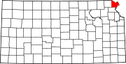
Townships Burr Oak | Center | Independence | Iowa | Marion | Union | Washington | Wayne | Wolf River
Unincorporated
communitiesIndian reservations Ioway Reservation‡
Footnotes ‡This populated place also has portions in an adjacent county or counties
Categories:- Doniphan County, Kansas
- National Register of Historic Places in Kansas by county
- Buildings and structures in Doniphan County, Kansas
-


Wikimedia Foundation. 2010.