- Doniphan, Kansas
-
Doniphan, Kansas — Unincorporated community — Location within the state of Kansas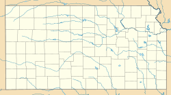
 Doniphan, Kansas
Coordinates: 39°38′30″N 95°4′51″W / 39.64167°N 95.08083°WCoordinates: 39°38′30″N 95°4′51″W / 39.64167°N 95.08083°W Country United States State Kansas County Doniphan Time zone Central (CST) (UTC-6) – Summer (DST) CDT (UTC-5) ZIP codes FIPS code GNIS feature ID Doniphan is a small unincorporated community in Doniphan County, Kansas, United States. The company that founded the town was organized on November 11, 1854. The post office opened March 3, 1855, and closed August 15, 1943.
Doniphan is part of the St. Joseph, MO–KS Metropolitan Statistical Area.
References
- Gray's Doniphan County History: A Record of the Happenings of Half a Hundred Years
- William G. Cutler's History of the State of Kansas
Municipalities and communities of Doniphan County, Kansas Cities 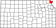
Townships Burr Oak | Center | Independence | Iowa | Marion | Union | Washington | Wayne | Wolf River
Unincorporated
communitiesBendena | Doniphan | Iowa Point
Indian reservations Ioway Reservation‡
Footnotes ‡This populated place also has portions in an adjacent county or counties
Categories:- Kansas geography stubs
- Populated places in Doniphan County, Kansas
- Unincorporated communities in Kansas
- St. Joseph metropolitan area


Wikimedia Foundation. 2010.