- Denton, Kansas
-
Denton, Kansas — City — Location of Denton, Kansas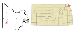
Coordinates: 39°43′54″N 95°16′12″W / 39.73167°N 95.27°WCoordinates: 39°43′54″N 95°16′12″W / 39.73167°N 95.27°W Country United States State Kansas County Doniphan Area – Total 0.1 sq mi (0.4 km2) – Land 0.1 sq mi (0.4 km2) – Water 0.0 sq mi (0.0 km2) Elevation 1,076 ft (328 m) Population (2010)[1] – Total 148 – Density 1,480/sq mi (571.4/km2) Time zone Central (CST) (UTC-6) – Summer (DST) CDT (UTC-5) ZIP code 66017 Area code(s) 785 FIPS code 20-17750[2] GNIS feature ID 0484628[3] Denton is a city in Doniphan County, Kansas, United States. As of the 2010 census, the city population was 148.[1] It is part of the St. Joseph, MO–KS Metropolitan Statistical Area.
Contents
Geography
Denton is located at 39°43′54″N 95°16′12″W / 39.73167°N 95.27°W (39.731568, -95.270025)[4]. According to the United States Census Bureau, the city has a total area of 0.1 square miles (0.26 km2), all of it land.
Demographics
Historical populations Census Pop. %± 1990 166 — 2000 186 12.0% 2010 148 −20.4% U.S. Decennial Census As of the census[2] of 2000, there were 186 people, 71 households, and 47 families residing in the city. The population density was 1,286.4 people per square mile (513.0/km²). There were 74 housing units at an average density of 511.8 per square mile (204.1/km²). The racial makeup of the city was 99.46% White, and 0.54% from two or more races. Hispanic or Latino of any race were 0.54% of the population.
There were 71 households out of which 38.0% had children under the age of 18 living with them, 62.0% were married couples living together, 2.8% had a female householder with no husband present, and 33.8% were non-families. 32.4% of all households were made up of individuals and 22.5% had someone living alone who was 65 years of age or older. The average household size was 2.62 and the average family size was 3.40.
In the city the population was spread out with 33.9% under the age of 18, 4.8% from 18 to 24, 29.0% from 25 to 44, 15.1% from 45 to 64, and 17.2% who were 65 years of age or older. The median age was 35 years. For every 100 females there were 95.8 males. For every 100 females age 18 and over, there were 89.2 males.
The median income for a household in the city was $30,500, and the median income for a family was $40,625. Males had a median income of $31,875 versus $20,417 for females. The per capita income for the city was $12,872. None of the families and 4.5% of the population were living below the poverty line, including no under eighteens and 6.9% of those over 64.
References
- ^ a b "2010 City Population and Housing Occupancy Status". U.S. Census Bureau. http://factfinder2.census.gov/faces/tableservices/jsf/pages/productview.xhtml?pid=DEC_10_PL_GCTPL2.ST13&prodType=table. Retrieved August 10, 2011.
- ^ a b "American FactFinder". United States Census Bureau. http://factfinder.census.gov. Retrieved 2008-01-31.
- ^ "US Board on Geographic Names". United States Geological Survey. 2007-10-25. http://geonames.usgs.gov. Retrieved 2008-01-31.
- ^ "US Gazetteer files: 2010, 2000, and 1990". United States Census Bureau. 2011-02-12. http://www.census.gov/geo/www/gazetteer/gazette.html. Retrieved 2011-04-23.
External links
- City
- Maps
- 2001 Denton City Map, KDOT
- 2010 Doniphan County Map, KDOT
Municipalities and communities of Doniphan County, Kansas Cities 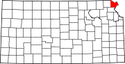
Townships Burr Oak | Center | Independence | Iowa | Marion | Union | Washington | Wayne | Wolf River
Unincorporated
communitiesIndian reservations Ioway Reservation‡
Footnotes ‡This populated place also has portions in an adjacent county or counties
Categories:- Cities in Kansas
- Populated places in Doniphan County, Kansas
- St. Joseph metropolitan area


Wikimedia Foundation. 2010.