- Marion Township, Doniphan County, Kansas
-
Marion Township — Township — Location in Doniphan County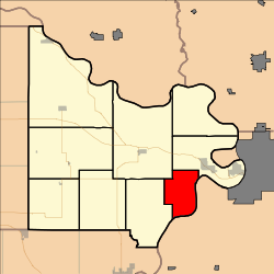
Coordinates: 39°43′15″N 095°01′01″W / 39.72083°N 95.01694°WCoordinates: 39°43′15″N 095°01′01″W / 39.72083°N 95.01694°W Country United States State Kansas County Doniphan Area - Total 18.01 sq mi (46.65 km2) - Land 17.5 sq mi (45.32 km2) - Water 0.51 sq mi (1.32 km2) 2.83% Elevation 1,053 ft (321 m) Population (2000) - Total 226 - Density 12.9/sq mi (5/km2) GNIS feature ID 0473034 Marion Township is a township in Doniphan County, Kansas, USA. As of the 2000 census, its population was 226.
Geography
Marion Township covers an area of 18.01 square miles (46.6 km2) and contains no incorporated settlements. According to the USGS, it contains one cemetery, Rosendale.
The streams of Brush Creek and Walnut Creek run through this township.
References
External links
Municipalities and communities of Doniphan County, Kansas Cities 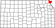
Townships Burr Oak | Center | Independence | Iowa | Marion | Union | Washington | Wayne | Wolf River
Unincorporated
communitiesIndian reservations Ioway Reservation‡
Footnotes ‡This populated place also has portions in an adjacent county or counties
Categories:- Townships in Doniphan County, Kansas
- Kansas geography stubs


Wikimedia Foundation. 2010.