- National Register of Historic Places listings in Atchison County, Kansas
-
 Location of Atchison County in Kansas
This is a list of the National Register of Historic Places listings in Atchison County, Kansas.
This is intended to be a complete list of the properties and districts on the National Register of Historic Places in Atchison County, Kansas, United States. The locations of National Register properties and districts for which the latitude and longitude coordinates are included below, may be seen in a Google map.[1]
There are 41 properties and districts listed on the National Register in the county.
-
- This National Park Service list is complete through NPS recent listings posted November 10, 2011.[2]
Current listings
[3] Landmark name [4] Image Date listed Location City or town Summary 1 Atchison Santa Fe Freight Depot October 11, 2001 200 S. Tenth St.
39°33′36″N 95°07′35″W / 39.56°N 95.126389°WAtchison Today the Santa-Fe Depot Rail Museum 2 Atchison County Courthouse 
April 16, 1975 Southwestern corner of 5th and Parallel Sts.
39°33′58″N 95°07′10″W / 39.566111°N 95.119444°WAtchison 3 Atchison County Memorial Hall April 18, 2007 819 Commercial St.
39°33′44″N 95°07′27″W / 39.562222°N 95.124167°WAtchison 4 Atchison Post Office March 16, 1972 621 Kansas St.
39°33′48″N 95°07′17″W / 39.563333°N 95.121389°WAtchison 5 Francis and Harriet Baker House August 28, 2003 823 N. 5th St.
39°34′13″N 95°07′08″W / 39.570278°N 95.118889°WAtchison 6 Benedictine College North Campus Historic Complex March 17, 1982 2nd and Division Sts.
39°34′21″N 95°06′52″W / 39.5725°N 95.114444°WAtchison 7 George T. and Minnie Searles Bolman House May 17, 2006 418 N. 4th St.
39°33′57″N 95°07′02″W / 39.565833°N 95.117222°WAtchison 8 Henry Braun House May 17, 2006 1307 Division St.
39°34′20″N 95°07′51″W / 39.572222°N 95.130833°WAtchison 9 J. P. Brown House April 14, 1975 805 N. 4th St.
39°34′10″N 95°07′05″W / 39.569444°N 95.118056°WAtchison 10 Burnes Rental Houses Historic District December 6, 2005 615, 617, and 621 N. 3rd St.
39°34′03″N 95°06′58″W / 39.5675°N 95.116111°WAtchison 11 Campbell Chapel AME Church January 17, 2003 715 Atchison St.
39°33′55″N 95°07′20″W / 39.565278°N 95.122222°WAtchison 12 John Drimmel, Sr. Farm May 20, 2004 16339 290th Rd.
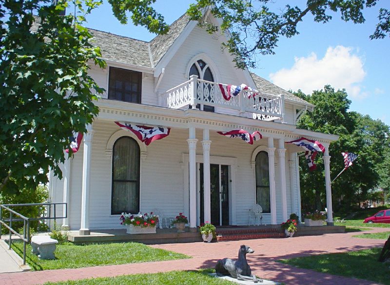
39°34′24″N 95°11′03″W / 39.573333°N 95.184167°WAtchison 13 Amelia Earhart Birthplace 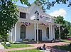
April 16, 1971 223 N. Terrace
39°33′49″N 95°06′52″W / 39.563611°N 95.114444°WAtchison 14 Amelia Earhart Historic District February 1, 2002 115-125, 200-227, 302-315, 318, 324 2nd St., 203-305 North Terrace, 124, 200, 300 3rd St., and 205, 112, and 224 Santa Fe St.
39°34′05″N 95°06′53″W / 39.568056°N 95.114722°WAtchison 15 Ebenezer Baptist Church November 30, 2005 826 Riley
39°34′09″N 95°07′28″W / 39.569167°N 95.124444°WAtchison 16 James M. Edmiston House May 17, 2006 311 S. 7th St.
39°33′33″N 95°07′18″W / 39.559167°N 95.121667°WAtchison 17 Glancy/Pennell House August 26, 1983 519 N. 5th St.
39°34′01″N 95°07′09″W / 39.566944°N 95.119167°WAtchison 18 Glick-Orr House February 26, 1992 503 N. Second St.
39°33′46″N 95°06′55″W / 39.562778°N 95.115278°WAtchison 19 A. J. Harwi House May 6, 1975 1103 Atchison St.
39°33′55″N 95°07′46″W / 39.565278°N 95.129444°WAtchison 20 Hausner House December 6, 2005 400 N. 3rd St.
39°33′56″N 95°06′57″W / 39.565556°N 95.115833°WAtchison 21 W. W. Hetherington House July 12, 1974 805 N. 5th St.
39°33′49″N 95°07′08″W / 39.563611°N 95.118889°WAtchison 22 Michael J. and Mattie Horan House May 17, 2006 822 N. 4th St.
39°34′13″N 95°07′02″W / 39.570278°N 95.117222°WAtchison 23 Frank Howard House October 15, 1984 305 N. Terrace
39°33′51″N 95°06′52″W / 39.564167°N 95.114444°WAtchison 24 Edgar W. Howe House March 16, 1972 1117 N. 3rd St.
39°34′28″N 95°07′01″W / 39.574444°N 95.116944°WAtchison 25 Jansen House December 6, 2005 806 N. 3rd St.
39°34′11″N 95°06′56″W / 39.569722°N 95.115556°WAtchison 26 Lanphear-Mitchell House December 6, 2005 417 N. 4th St.
39°33′56″N 95°07′04″W / 39.565556°N 95.117778°WAtchison 27 Lincoln School June 7, 2006 801 Division St.
39°34′18″N 95°07′25″W / 39.571667°N 95.123611°WAtchison 28 McInteer Villa March 26, 1975 1301 Kansas St.
39°33′48″N 95°08′00″W / 39.563333°N 95.133333°WAtchison 29 Mount St. Scholastica Convent April 13, 1972 801 S. 8th St.
39°32′06″N 95°07′28″W / 39.535°N 95.124444°WAtchison 30 H. E. Muchnic House July 12, 1974 704 N. 4th St.
39°34′07″N 95°07′02″W / 39.568611°N 95.117222°WAtchison 31 Robert L. Pease House August 26, 1983 203 N. 2nd St.
39°33′47″N 95°06′55″W / 39.563056°N 95.115278°WAtchison 32 Price Villa March 16, 1972 801 S. 8th St.
39°33′13″N 95°07′30″W / 39.553611°N 95.125°WAtchison 33 Ronald and Dorcas Ramsay House June 7, 2006 1415 Riverview Dr.
39°32′44″N 95°06′51″W / 39.545556°N 95.114167°WAtchison 34 Schmitt House November 30, 2005 1110 W. Division St.
39°34′18″N 95°07′51″W / 39.571667°N 95.130833°WAtchison 35 St. Patrick's Catholic Church November 25, 1998 234th Rd., 2 miles west of U.S. Route 73
39°28′10″N 95°07′17″W / 39.469444°N 95.121389°WAtchison 36 Frederick W. Stein House January 14, 2004 324 Santa Fe
39°33′51″N 95°07′00″W / 39.564167°N 95.116667°WAtchison 37 Stranger Creek Warren Truss Bridge October 12, 2004 On Haskell Rd., 0.8 miles south of the junction with 262 Rd., 0.5 miles south of Farmington
39°30′41″N 95°18′36″W / 39.511389°N 95.31°WFarmington 38 Trinity Episcopal Church April 4, 1985 300 S. 5th St.
39°33′33″N 95°07′06″W / 39.559167°N 95.118333°WAtchison 39 B. P. Waggener House May 3, 1974 819 N. 4th St.
39°34′13″N 95°07′04″W / 39.570278°N 95.117778°WAtchison 40 Balie P. Waggener House May 17, 2006 415 W. Riley St.
39°34′16″N 95°07′05″W / 39.571111°N 95.118056°WAtchison 41 Wherrett-Mize Drug Company Building July 6, 2010 201 Main St.
39°33′39″N 95°06′55″W / 39.560833°N 95.115278°WAtchison See also
- List of National Historic Landmarks in Kansas
- National Register of Historic Places listings in Kansas
References
- ^ The latitude and longitude information provided in this table was derived originally from the National Register Information System, which has been found to be fairly accurate for about 99% of listings. For about 1% of NRIS original coordinates, experience has shown that one or both coordinates are typos or otherwise extremely far off; some corrections may have been made. A more subtle problem causes many locations to be off by up to 150 yards, depending on location in the country: most NRIS coordinates were derived from tracing out latitude and longitudes off of USGS topographical quadrant maps created under the North American Datum of 1927, which differs from the current, highly accurate WGS84 GPS system used by Google maps. Chicago is about right, but NRIS longitudes in Washington are higher by about 4.5 seconds, and are lower by about 2.0 seconds in Maine. Latitudes differ by about 1.0 second in Florida. Some locations in this table may have been corrected to current GPS standards.
- ^ "National Register of Historic Places: Weekly List Actions". National Park Service, United States Department of the Interior. Retrieved on November 10, 2011.
- ^ Numbers represent an ordering by significant words. Various colorings, defined here, differentiate National Historic Landmark sites and National Register of Historic Places Districts from other NRHP buildings, structures, sites or objects.
- ^ "National Register Information System". National Register of Historic Places. National Park Service. . http://nrhp.focus.nps.gov/natreg/docs/All_Data.html.
Municipalities and communities of Atchison County, Kansas Cities 
Townships Benton | Center | Grasshopper | Kapioma | Lancaster | Mount Pleasant | Shannon | Walnut
Unincorporated
communitiesIndian reservations Kickapoo Indian Reservation of Kansas‡
Footnotes ‡This populated place also has portions in an adjacent county or counties
Categories:- Atchison County, Kansas
- National Register of Historic Places in Kansas by county
- Buildings and structures in Atchison County, Kansas
-


Wikimedia Foundation. 2010.