- National Register of Historic Places listings in Floyd County, Iowa
-
 Location of Floyd County in Iowa
This is a list of the National Register of Historic Places listings in Floyd County, Iowa.
This is intended to be a complete list of the properties and districts on the National Register of Historic Places in Floyd County, Iowa, United States. Latitude and longitude coordinates are provided for many National Register properties and districts; these locations may be seen together in a Google map.[1]
There are 18 properties and districts listed on the National Register in the county.
-
- This National Park Service list is complete through NPS recent listings posted November 10, 2011.[2]
Current listings
[3] Landmark name [4] Image Date listed Location City or town Summary 1 Brooks Round Barn 
June 30, 1986 West of U.S. Route 218
42°57′00″N 92°35′04″W / 42.95°N 92.584444°WNashua 2 Central Park-North Main Street Historic District August 10, 1976 N. Main St. and N. Jackson St.
43°04′06″N 92°40′43″W / 43.068333°N 92.678611°WCharles City 3 Cook Farm June 18, 1979 South of Charles City on U.S. Route 218
43°01′51″N 92°38′41″W / 43.030833°N 92.644722°WCharles City 4 A.B.C. Dodd House May 22, 1978 310 3rd Ave.
43°03′55″N 92°40′06″W / 43.065278°N 92.668333°WCharles City 5 Dr. Salsbury's Laboratories, Main Office and Production Laboratory Building March 7, 1996 500 Gilbert St.
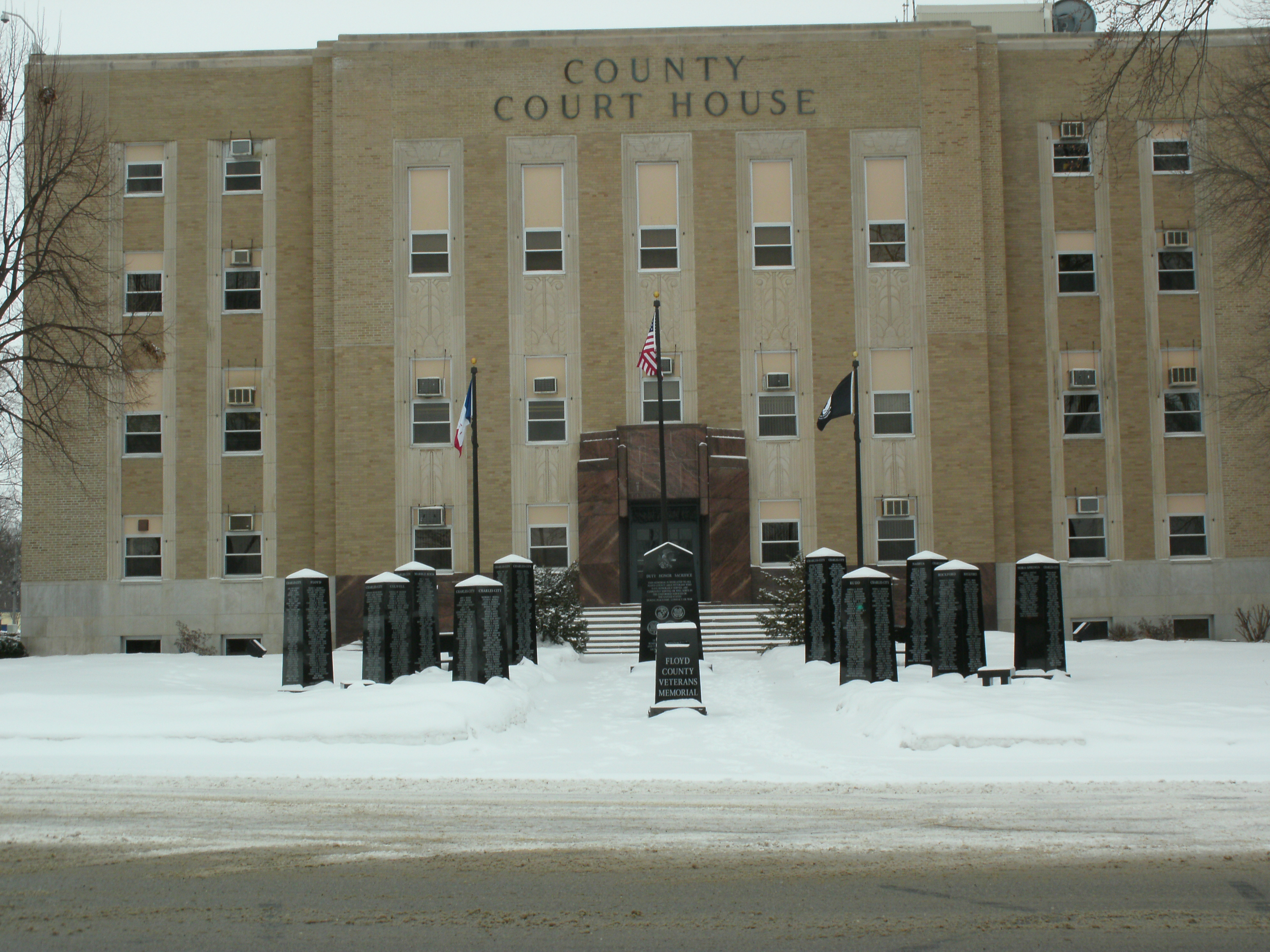
43°03′47″N 92°40′44″W / 43.063056°N 92.678889°WCharles City 6 Floyd County Court House 
August 28, 2003 101 S. Main St.
43°03′56″N 92°40′54″W / 43.065556°N 92.681667°WCharles City 7 Charles Walter Hart House January 25, 1980 800 3rd Ave.
43°03′21″N 92°39′35″W / 43.055833°N 92.659722°WCharles City 8 Hawkeye Street Underpass June 25, 1998 South Hawkeye St. under the railroad line
43°08′24″N 93°00′20″W / 43.14°N 93.005556°WNora Springs 9 Lucius and Maria Clinton Lane House April 24, 1995 2379 Timber Ave.
43°00′49″N 92°40′22″W / 43.013611°N 92.672778°WCharles City 10 Main Street Bridge None Main St. over the Cedar River
43°03′48″N 92°40′35″W / 43.063333°N 92.676389°WCharles City 11 Marble Rock Bank November 10, 1982 313 Bradford St.
42°57′55″N 92°52′02″W / 42.965278°N 92.867222°WMarble Rock 12 Alvin Miller House November 16, 1978 1107 Court St.
43°04′05″N 92°41′04″W / 43.068056°N 92.684444°WCharles City 13 Charles Henry Parr House January 24, 1980 100 W. Hulin St.
43°04′23″N 92°40′55″W / 43.073056°N 92.681944°WCharles City 14 River Street Bridge June 25, 1998 River St. over a drainage ditch
42°58′02″N 92°52′05″W / 42.967222°N 92.868056°WMarble Rock 15 Rockford Mill July 28, 1983 Shell Rock River at 4th and Main St.
42°57′37″N 92°56′31″W / 42.960278°N 92.941944°WRockford 16 Spotts Round Barn June 30, 1986 Iowa Highway 14
43°03′40″N 92°43′36″W / 43.061111°N 92.726667°WCharles City 17 Tyden Farm No. 6 Farmstead Historic District June 11, 2009 1145 300th St. Dougherty 18 Wildwood Park Historic District September 25, 1998 1 Wildwood Rd.
43°03′46″N 92°41′37″W / 43.062778°N 92.693611°WCharles City See also
References
- ^ The latitude and longitude information provided in this table was derived originally from the National Register Information System, which has been found to be fairly accurate for about 99% of listings. For about 1% of NRIS original coordinates, experience has shown that one or both coordinates are typos or otherwise extremely far off; some corrections may have been made. A more subtle problem causes many locations to be off by up to 150 yards, depending on location in the country: most NRIS coordinates were derived from tracing out latitude and longitudes off of USGS topographical quadrant maps created under North American Datum of 1927, which differs from the current, highly accurate GPS system used by Google maps. Chicago is about right, but NRIS longitudes in Washington are higher by about 4.5 seconds, and are lower by about 2.0 seconds in Maine. Latitudes differ by about 1.0 second in Florida. Some locations in this table may have been corrected to current GPS standards.
- ^ "National Register of Historic Places: Weekly List Actions". National Park Service, United States Department of the Interior. Retrieved on November 10, 2011.
- ^ Numbers represent an ordering by significant words. Various colorings, defined here, differentiate National Historic Landmark sites and National Register of Historic Places Districts from other NRHP buildings, structures, sites or objects.
- ^ "National Register Information System". National Register of Historic Places. National Park Service. . http://nrhp.focus.nps.gov/natreg/docs/All_Data.html.
U.S. National Register of Historic Places Topics Lists by states Alabama • Alaska • Arizona • Arkansas • California • Colorado • Connecticut • Delaware • Florida • Georgia • Hawaii • Idaho • Illinois • Indiana • Iowa • Kansas • Kentucky • Louisiana • Maine • Maryland • Massachusetts • Michigan • Minnesota • Mississippi • Missouri • Montana • Nebraska • Nevada • New Hampshire • New Jersey • New Mexico • New York • North Carolina • North Dakota • Ohio • Oklahoma • Oregon • Pennsylvania • Rhode Island • South Carolina • South Dakota • Tennessee • Texas • Utah • Vermont • Virginia • Washington • West Virginia • Wisconsin • WyomingLists by territories Lists by associated states Other  Category:National Register of Historic Places •
  Portal:National Register of Historic Places
Municipalities and communities of Floyd County, Iowa County seat: Charles City Cities Charles City | Colwell | Floyd | Marble Rock | Nashua‡ | Nora Springs‡ | Rockford | Rudd

Townships Cedar | Floyd | Niles | Pleasant Grove | Riverton | Rock Grove | Rockford | Rudd | Saint Charles | Scott | Ulster | Union
Footnotes ‡This populated place also has portions in an adjacent county or counties
Categories:- National Register of Historic Places in Iowa by county
- Floyd County, Iowa
- Buildings and structures in Floyd County, Iowa
-


Wikimedia Foundation. 2010.