- National Register of Historic Places listings in Cedar County, Iowa
-
 Location of Cedar County in Iowa
This is a list of the National Register of Historic Places listings in Cedar County, Iowa.
This is intended to be a complete list of the properties and districts on the National Register of Historic Places in Cedar County, Iowa, United States. Latitude and longitude coordinates are provided for many National Register properties and districts; these locations may be seen together in a Google map.[1]
There are 16 properties and districts listed on the National Register in the county, including 1 National Historic Landmark.
-
- This National Park Service list is complete through NPS recent listings posted November 10, 2011.[2]
Current listings
[3] Landmark name [4] Image Date listed Location City or town Summary 1 Cedar County Sheriff's House and Jail September 13, 2003 118 W. 4th St.
41°46′09″N 91°07′45″W / 41.769167°N 91.129167°WTipton 2 Downey Savings Bank July 12, 1976 Front St.
41°36′57″N 91°20′58″W / 41.615833°N 91.349444°WDowney 3 Floral Hall November 7, 1976 West of Tipton at the Cedar County Fairgrounds
41°46′25″N 91°08′38″W / 41.773611°N 91.143889°WTipton 4 William Green House April 29, 1999 1709 Madison St.
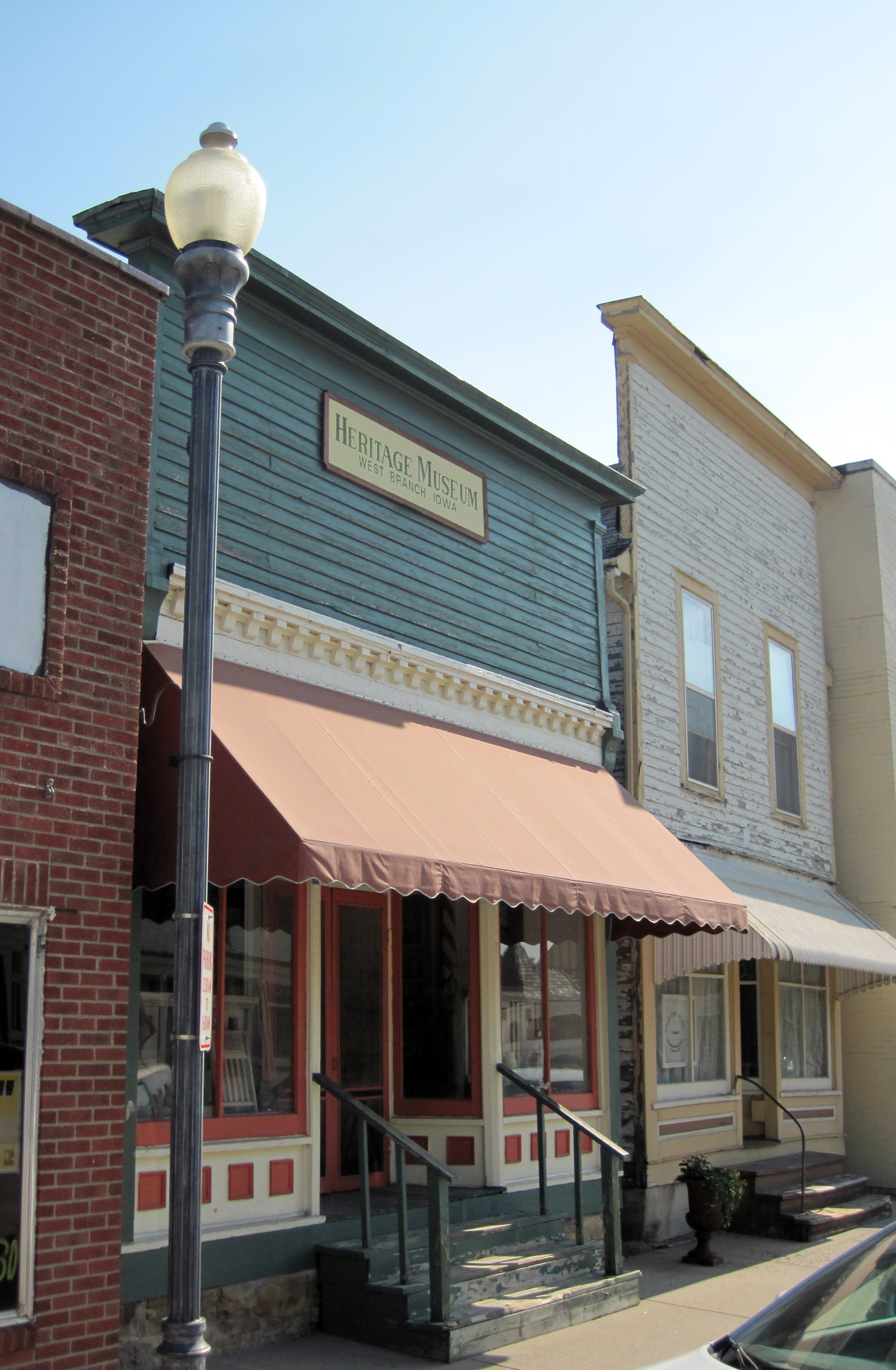
41°40′26″N 91°09′43″W / 41.673889°N 91.161944°WRochester 5 Gruwell and Crew General Store 
September 9, 1982 109 W. Main St.
41°40′05″N 91°20′49″W / 41.668056°N 91.346944°WWest Branch On the Most Endangered list of the Iowa Historic Preservation Alliance[5] 6 Hannah Morse Fowler Hall House May 1, 1998 1285 Garfield Ave.
41°45′32″N 91°15′15″W / 41.758889°N 91.254167°WBuchanan 7 Herbert Hoover National Historic Site 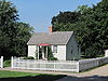
October 15, 1966 Off Interstate 80
41°40′05″N 91°20′58″W / 41.668056°N 91.349444°WWest Branch 8 Hotel Tipton November 5, 1998 524-527 Cedar St.
41°46′15″N 91°07′43″W / 41.770833°N 91.128611°WTipton 9 Kreinbring Phillips 66 Gas Station August 10, 2000 200 Main St.
41°51′28″N 90°55′13″W / 41.857778°N 90.920278°WLowden 10 Lincoln Hotel June 28, 1996 408 Main St.
41°51′28″N 90°55′35″W / 41.857778°N 90.926389°WLowden 11 Mill Creek Bridge June 25, 1998 Plum St. over Mill Creek
41°54′15″N 91°03′53″W / 41.904167°N 91.064722°WClarence 12 Red Oak Grove Presbyterian Church and Cemetery February 3, 2010 751 King Ave.
41°50′09″N 91°09′25″W / 41.835947°N 91.157072°WTipton 13 John Christian and Bertha Landrock Reichert House December 19, 1991 508 E. 4th St.
41°46′09″N 91°07′13″W / 41.769167°N 91.120278°WTipton 14 St. Paul's Episcopal Church and Parish Hall January 3, 1985 206 6th Ave.
41°35′55″N 90°54′46″W / 41.598611°N 90.912778°WDurant 15 Tipton State Bank September 14, 2000 501 Cedar St.
41°46′13″N 91°07′42″W / 41.770278°N 91.128333°WTipton 16 West Branch Commercial Historic District 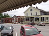
April 7, 1987 W. Main and N. Downey Sts.; also N. Downey and E. and W. Main Sts.; also 124 W. Main St.
41°40′23″N 91°20′54″W / 41.673056°N 91.348333°WWest Branch Second and third sets of addresses represent boundary increases See also
References
- ^ The latitude and longitude information provided in this table was derived originally from the National Register Information System, which has been found to be fairly accurate for about 99% of listings. For about 1% of NRIS original coordinates, experience has shown that one or both coordinates are typos or otherwise extremely far off; some corrections may have been made. A more subtle problem causes many locations to be off by up to 150 yards, depending on location in the country: most NRIS coordinates were derived from tracing out latitude and longitudes off of USGS topographical quadrant maps created under North American Datum of 1927, which differs from the current, highly accurate GPS system used by Google maps. Chicago is about right, but NRIS longitudes in Washington are higher by about 4.5 seconds, and are lower by about 2.0 seconds in Maine. Latitudes differ by about 1.0 second in Florida. Some locations in this table may have been corrected to current GPS standards.
- ^ "National Register of Historic Places: Weekly List Actions". National Park Service, United States Department of the Interior. Retrieved on November 10, 2011.
- ^ Numbers represent an ordering by significant words. Various colorings, defined here, differentiate National Historic Landmark sites and National Register of Historic Places Districts from other NRHP buildings, structures, sites or objects.
- ^ "National Register Information System". National Register of Historic Places. National Park Service. . http://nrhp.focus.nps.gov/natreg/docs/All_Data.html.
- ^ Iowa's Most Endangered Properties, http://www.iowapreservation.org/endangered.php
U.S. National Register of Historic Places Topics Lists by states Alabama • Alaska • Arizona • Arkansas • California • Colorado • Connecticut • Delaware • Florida • Georgia • Hawaii • Idaho • Illinois • Indiana • Iowa • Kansas • Kentucky • Louisiana • Maine • Maryland • Massachusetts • Michigan • Minnesota • Mississippi • Missouri • Montana • Nebraska • Nevada • New Hampshire • New Jersey • New Mexico • New York • North Carolina • North Dakota • Ohio • Oklahoma • Oregon • Pennsylvania • Rhode Island • South Carolina • South Dakota • Tennessee • Texas • Utah • Vermont • Virginia • Washington • West Virginia • Wisconsin • WyomingLists by territories Lists by associated states Other  Category:National Register of Historic Places •
  Portal:National Register of Historic Places
Municipalities and communities of Cedar County, Iowa County seat: Tipton Cities Bennett | Clarence | Durant‡ | Lowden | Mechanicsville | Stanwood | Tipton | West Branch‡ | Wilton‡

Townships Cass | Center | Dayton | Fairfield | Farmington | Fremont | Gower | Inland | Iowa | Linn | Massillon | Pioneer | Red Oak | Rochester | Springdale | Springfield | Sugar Creek
Unincorporated
communitiesMassillon | Springdale | Sunbury
Footnotes ‡This populated place also has portions in an adjacent county or counties
Categories:- National Register of Historic Places in Iowa by county
- Cedar County, Iowa
- Buildings and structures in Cedar County, Iowa
-


Wikimedia Foundation. 2010.