- National Register of Historic Places listings in Fayette County, Iowa
-
 Location of Fayette County in Iowa
This is a list of the National Register of Historic Places listings in Fayette County, Iowa.
This is intended to be a complete list of the properties and districts on the National Register of Historic Places in Fayette County, Iowa, United States. Latitude and longitude coordinates are provided for many National Register properties and districts; these locations may be seen together in a Google map.[1]
There are 27 properties listed on the National Register in the county.
-
- This National Park Service list is complete through NPS recent listings posted November 10, 2011.[2]
[3] Landmark name [4] Image Date listed Location City or town Summary 1 Abraham Lincoln Statue and Park October 30, 2000 Junction of Mill and Stone
43°00′13″N 91°39′53″W / 43.003611°N 91.664722°WClermont 2 Bigler Building June 9, 1995 210 Mill St.
43°00′01″N 91°39′22″W / 43.000278°N 91.656111°WClermont 3 Chicago, Milwaukee, St. Paul and Pacific Railroad Company Depot December 28, 1978 Northeast of Fayette off Iowa Highway 150
42°52′16″N 91°46′59″W / 42.871111°N 91.783056°WFayette 4 Church of the Saviour Episcopal Church and David Henderson Statue October 30, 2000 Junction of Mill and Thompson
43°00′10″N 91°39′14″W / 43.002778°N 91.653889°WClermont 5 Clermont Public School November 22, 1995 505 Larrabee St.
42°59′48″N 91°39′11″W / 42.996667°N 91.653056°WClermont 6 College Hall November 7, 1976 200 block of E. Clark
42°50′30″N 91°48′07″W / 42.841667°N 91.801944°WFayette 7 Eldorado Bridge June 25, 1998 State St. over the Turkey River
43°03′13″N 91°50′05″W / 43.053611°N 91.834722°WEldorado 8 The Elgin Block May 8, 2008 225-231 Center St.
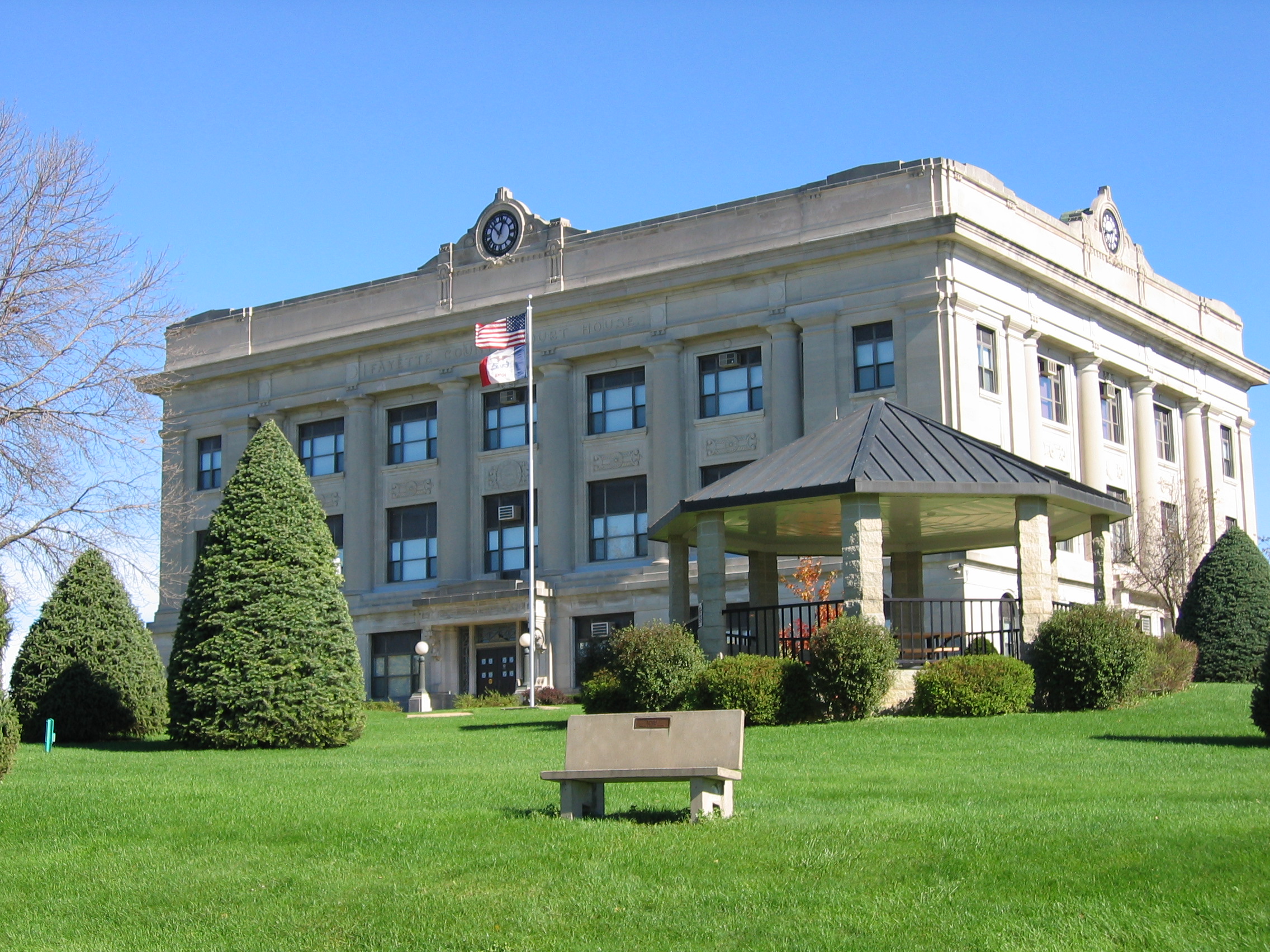
42°57′26″N 91°37′37″W / 42.95735°N 91.62687°WEldorado 9 Fayette County Courthouse 
July 2, 1981 Pine St.
42°57′38″N 91°48′21″W / 42.960556°N 91.805833°WWest Union 10 First Baptist Church of West Union October 7, 1999 Main and Vine Sts.
42°57′47″N 91°48′30″W / 42.963056°N 91.808333°WWest Union 11 Grimes Octagon Barn June 30, 1986 Off Iowa Highway 56
42°56′10″N 91°45′01″W / 42.936111°N 91.750278°WWest Union 12 Alfred Hanson House July 12, 1984 403 N. Frederick Ave.
42°41′01″N 91°54′46″W / 42.683611°N 91.912778°WOelwein 13 Hardware Building July 15, 1977 223 Mill St.
42°50′23″N 91°39′25″W / 42.839722°N 91.656944°WWadena 14 Hotel Mealey January 27, 1983 102 S. Frederick Ave.
42°40′37″N 91°54′49″W / 42.676944°N 91.913611°WOelwein 15 Maple View Sanitarium July 21, 1998 100 N. Walnut St.
42°57′41″N 91°48′11″W / 42.961389°N 91.803056°WWest Union 16 Maynard Town Hall and Jail October 30, 1997 330 Main St., W.
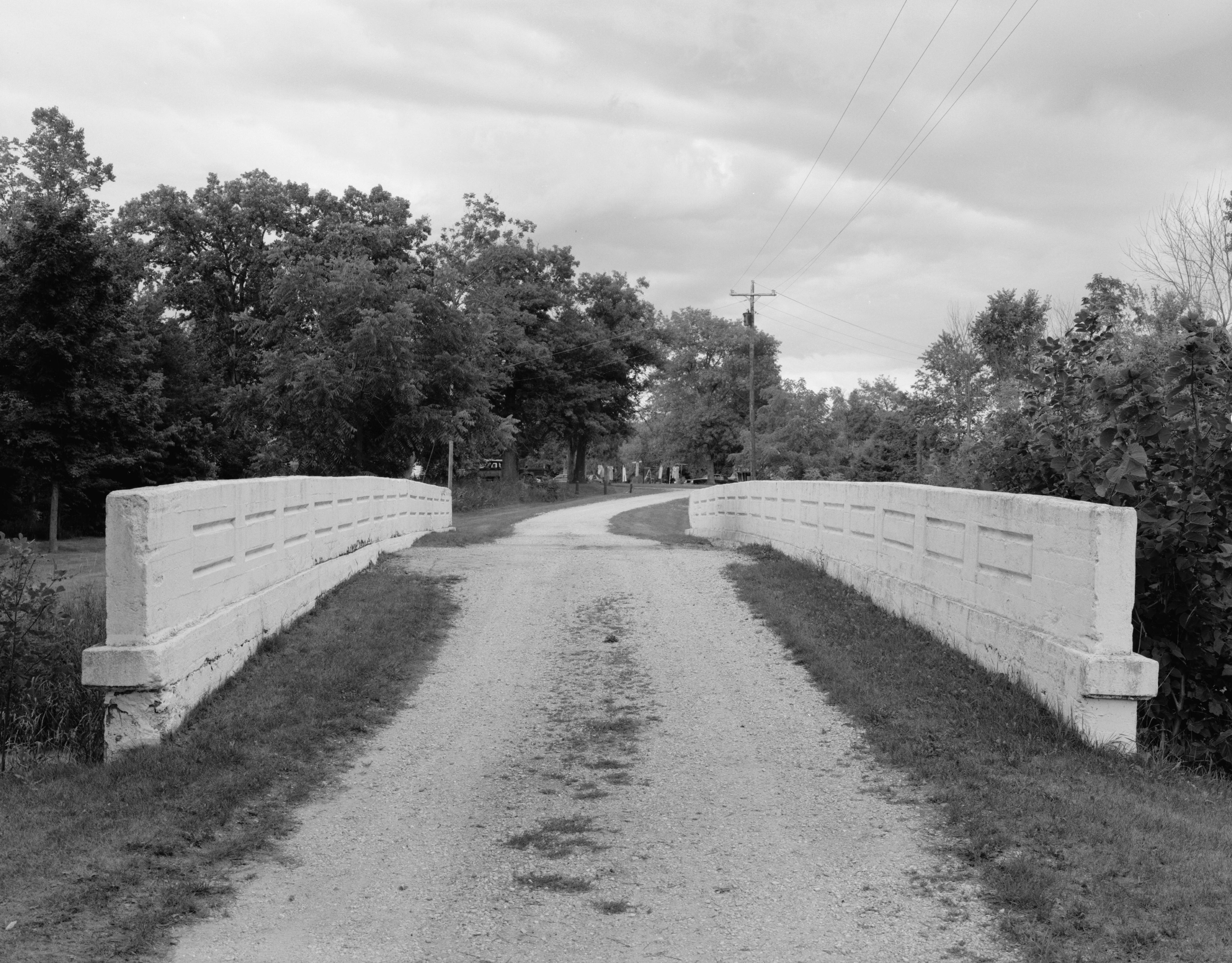
42°46′42″N 91°53′11″W / 42.778333°N 91.886389°WMaynard 17 Mill Race Bridge June 25, 1998 Pheasant Rd. over the Turkey River
43°04′38″N 91°53′19″W / 43.077222°N 91.888611°WWest Union 18 Montauk 
February 21, 1973 1 mile northeast of Clermont on U.S. Route 18
43°00′49″N 91°38′25″W / 43.013611°N 91.640278°WClermont 19 August Nus Polygonal Barn June 30, 1986 County Road C2, W.
42°45′35″N 91°38′23″W / 42.759722°N 91.639722°WArlington 20 Otter Creek Bridge June 25, 1998 40th St. over Otter Creek
42°41′10″N 91°56′49″W / 42.686111°N 91.946944°WOelwein 21 St. Luke's School and Recreation Center August 24, 2005 212 East Main
43°04′01″N 91°55′49″W / 43.066944°N 91.930278°WSt. Lucas 22 Stoe Creek Bridge June 25, 1998 V Ave. over Stoe Creek
42°47′30″N 92°00′08″W / 42.791667°N 92.002222°WOelwein 23 Sumner Bridge June 25, 1998 160th St. over the Little Wapsipinicon River
43°04′39″N 91°53′21″W / 43.0775°N 91.889167°WSumner 24 Twin Bridge 
June 25, 1998 130th St. over the Little Volga River
42°50′04″N 91°51′53″W / 42.834444°N 91.864722°WFayette 25 Union Sunday School November 5, 1974 McGregor and Larrabee Sts.
43°00′10″N 91°39′25″W / 43.002778°N 91.656944°WClermont 26 Vine Street Bridge June 25, 1998 South Vine St. over Otter Creek
42°57′33″N 91°49′09″W / 42.959167°N 91.819167°WWest Union 27 West Auburn Bridge 
June 25, 1998 Near Neon Rd. over the Turkey River
43°00′59″N 91°52′43″W / 43.016389°N 91.878611°WWest Union See also
References
- ^ The latitude and longitude information provided in this table was derived originally from the National Register Information System, which has been found to be fairly accurate for about 99% of listings. For about 1% of NRIS original coordinates, experience has shown that one or both coordinates are typos or otherwise extremely far off; some corrections may have been made. A more subtle problem causes many locations to be off by up to 150 yards, depending on location in the country: most NRIS coordinates were derived from tracing out latitude and longitudes off of USGS topographical quadrant maps created under the North American Datum of 1927, which differs from the current, highly accurate WGS84 GPS system used by Google maps. Chicago is about right, but NRIS longitudes in Washington are higher by about 4.5 seconds, and are lower by about 2.0 seconds in Maine. Latitudes differ by about 1.0 second in Florida. Some locations in this table may have been corrected to current GPS standards.
- ^ "National Register of Historic Places: Weekly List Actions". National Park Service, United States Department of the Interior. Retrieved on November 10, 2011.
- ^ Numbers represent an ordering by significant words. Various colorings, defined here, differentiate National Historic Landmark sites and National Register of Historic Places Districts from other NRHP buildings, structures, sites or objects.
- ^ "National Register Information System". National Register of Historic Places. National Park Service. . http://nrhp.focus.nps.gov/natreg/docs/All_Data.html.
U.S. National Register of Historic Places Topics Lists by states Alabama • Alaska • Arizona • Arkansas • California • Colorado • Connecticut • Delaware • Florida • Georgia • Hawaii • Idaho • Illinois • Indiana • Iowa • Kansas • Kentucky • Louisiana • Maine • Maryland • Massachusetts • Michigan • Minnesota • Mississippi • Missouri • Montana • Nebraska • Nevada • New Hampshire • New Jersey • New Mexico • New York • North Carolina • North Dakota • Ohio • Oklahoma • Oregon • Pennsylvania • Rhode Island • South Carolina • South Dakota • Tennessee • Texas • Utah • Vermont • Virginia • Washington • West Virginia • Wisconsin • WyomingLists by territories Lists by associated states Other Municipalities and communities of Fayette County, Iowa Cities 
Townships Unincorporated
communitiesFootnotes ‡This populated place also has portions in an adjacent county or counties
Categories:- National Register of Historic Places in Iowa by county
- Fayette County, Iowa
- Buildings and structures in Fayette County, Iowa
-


Wikimedia Foundation. 2010.