- National Register of Historic Places listings in Mahaska County, Iowa
-
 Location of Mahaska County in Iowa
This is a list of the National Register of Historic Places listings in Mahaska County, Iowa.
This is intended to be a complete list of the properties and districts on the National Register of Historic Places in Mahaska County, Iowa, United States. Latitude and longitude coordinates are provided for many National Register properties and districts; these locations may be seen together in a Google map.[1]
There are 46 properties and districts listed on the National Register in the county.
-
- This National Park Service list is complete through NPS recent listings posted November 10, 2011.[2]
Current listings
[3] Landmark name [4] Image Date listed Location City or town Summary 1 Carroll Alsop House November 9, 1988 1907 A Ave., E.
41°17′49″N 92°37′21″W / 41.296944°N 92.6225°WOskaloosa 2 Bellefountain Bridge May 15, 1998 Ashland Ave. over the Des Moines River
41°19′58″N 92°51′56″W / 41.332778°N 92.865556°WTracy 3 Dr. William E. and Ethel Rosenberger Berry House March 29, 1996 116 Rosenberger Ave.
41°18′22″N 92°38′46″W / 41.306111°N 92.646111°WOskaloosa 4 Thomas J. Conover House March 28, 1996 1010 N. Market St.
41°18′14″N 92°38′39″W / 41.303889°N 92.644167°WOskaloosa 5 Edmundson Park Historic District September 27, 2007 Junction of 11th Ave., W. and Edmundson Dr.
41°17′07″N 92°39′36″W / 41.28524°N 92.65991°WOskaloosa 6 Eveland Bridge 
May 15, 1998 Fulton Ave. over the Des Moines River
41°14′34″N 92°45′24″W / 41.242708°N 92.756528°WOskaloosa 7 Forest Cemetery Entrance December 13, 1991 Junction of N. 9th St. and J Ave., E.
41°18′12″N 92°38′02″W / 41.303333°N 92.633889°WOskaloosa 8 E.H. Gibbs House December 13, 1991 William Penn University campus, N. Market Extension
41°18′31″N 92°38′41″W / 41.308611°N 92.644722°WOskaloosa 9 Ulysses Simpson Grant Elementary School December 10, 2008 715 B Ave., E.
41°17′50″N 92°38′16″W / 41.29716°N 92.6378°WOskaloosa 10 Phil Hoffman House 
December 13, 1991 807 High Ave., E.
41°17′44″N 92°38′09″W / 41.295556°N 92.635833°WOskaloosa 11 Iowa Yearly Meeting House-College Avenue Friends Church March 29, 1996 912 N. C St.
41°18′12″N 92°38′53″W / 41.303333°N 92.648056°WOskaloosa 12 William A. and Ida C. Johnson House March 28, 1996 307 College Ave.
41°18′14″N 92°38′50″W / 41.303889°N 92.647222°WOskaloosa 13 Dr. William H. and Mae R. Klose House March 29, 1996 1002 Penn Boulevard
41°18′23″N 92°38′51″W / 41.306389°N 92.6475°WOskaloosa 14 Lake Keomah State Park, Bathhouse-Lodge Area (Area A) November 15, 1990 Off Iowa Highway 371 south of its junction with Iowa Highway 92
41°17′26″N 92°32′27″W / 41.290556°N 92.540833°WOskaloosa 15 Lake Keomah State Park, Erosion Control Area (Area B) November 15, 1990 Off Iowa Highway 371 south of its junction with Iowa Highway 92
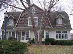
41°17′07″N 92°32′32″W / 41.285278°N 92.542222°WOskaloosa 16 Jack Lamberson House November 9, 1988 511 N. Park Ave.
41°18′01″N 92°37′37″W / 41.300278°N 92.626944°WOskaloosa 17 Lincoln School December 13, 1991 911 B Ave., W.
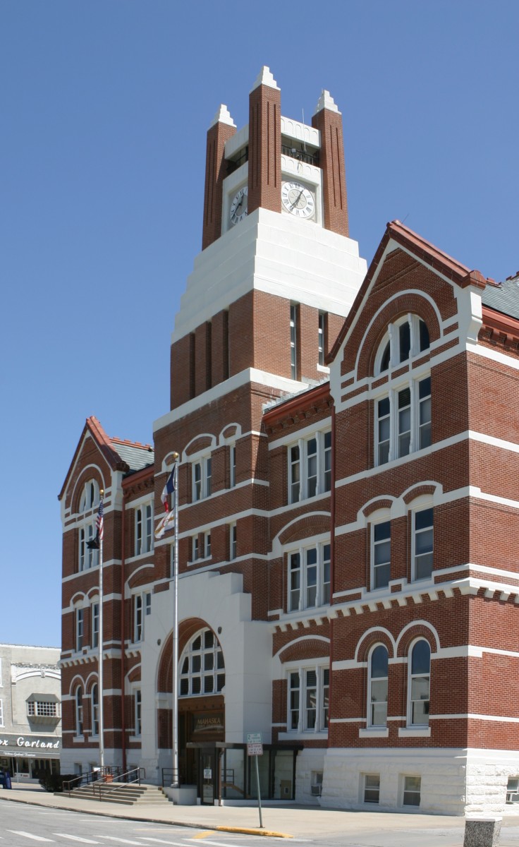
41°17′51″N 92°39′17″W / 41.2975°N 92.654722°WOskaloosa 18 Mahaska County Courthouse 
July 2, 1981 Market St. and 2nd Ave.
41°17′42″N 92°38′35″W / 41.295°N 92.643056°WOskaloosa 19 Maj. James W. McMullin House April 11, 1985 403 1st Ave., E.
41°17′40″N 92°38′26″W / 41.294444°N 92.640556°WOskaloosa 20 W.A. McNeill House October 21, 1999 1282 C Ave., E.
41°17′54″N 92°37′36″W / 41.298333°N 92.626667°WOskaloosa 21 Daniel Nelson House and Barn 
November 20, 1974 Iowa Highway 1
41°19′14″N 92°37′50″W / 41.320556°N 92.630556°WOskaloosa 22 North Skunk River Bridge May 15, 1998 County Road G13 over the North Skunk River
41°29′41″N 92°38′00″W / 41.494722°N 92.633333°WNew Sharon 23 Oskaloosa City Hall December 13, 1991 Northeastern corner of the junction of S. Market St. and 2nd Ave., E.
41°17′37″N 92°38′40″W / 41.293611°N 92.644444°WOskaloosa 24 Oskaloosa City Park and Band Stand July 28, 1983 City Park
41°17′42″N 92°38′38″W / 41.295°N 92.643889°WOskaloosa 25 Oskaloosa City Square Commercial Historic District April 10, 1986 Roughly bounded by A Ave., E, N. and S. 2nd St., 2nd Ave., E, and N. and S. A St.
41°17′48″N 92°38′39″W / 41.296667°N 92.644167°WOskaloosa 26 Oskaloosa Fire Station December 13, 1991 109-111 2nd Ave., E.
41°17′37″N 92°38′39″W / 41.293611°N 92.644167°WOskaloosa 27 Oskaloosa Monthly Meeting of Friends Parsonage March 29, 1996 910 N. C St.
41°18′10″N 92°38′53″W / 41.302778°N 92.648056°WOskaloosa 28 Oskaloosa Public Library December 13, 1991 Southwestern corner of the junction of Market St. and 2nd Ave.
41°17′35″N 92°38′42″W / 41.293056°N 92.645°WOskaloosa 29 Paradise Block Historic District December 13, 1991 402, 406, 408, 410, 414, 418, and 510-714 High Ave. E.
41°17′43″N 92°38′18″W / 41.295278°N 92.638333°WOskaloosa 30 Penn College Historic District April 4, 1996 201 Trueblood Ave.
41°18′32″N 92°38′47″W / 41.308889°N 92.646389°WOskaloosa 31 Pierson-Betts House March 28, 1996 815 Penn Boulevard
41°18′22″N 92°38′52″W / 41.306111°N 92.647778°WOskaloosa 32 President's Cottage March 28, 1996 425 College Ave.
41°18′13″N 92°39′00″W / 41.303611°N 92.65°WOskaloosa 33 Rock Island Passenger Depot October 30, 1989 Rock Island Ave. between 1st and 2nd Sts.
41°17′21″N 92°38′34″W / 41.289167°N 92.642778°WOskaloosa 34 Rose Hill Methodist Episcopal Church April 11, 2003 304 Main St.
41°19′14″N 92°27′55″W / 41.320556°N 92.465278°WRose Hill 35 St. James Episcopal Church, Oskaloosa December 13, 1991 Southwestern corner of the junction of 1st Ave. and S. 3rd St.
41°17′39″N 92°38′29″W / 41.294167°N 92.641389°WOskaloosa 36 Seeberger-Loring-Kilburn House July 14, 1983 509 High Ave., E.
41°17′44″N 92°38′22″W / 41.295556°N 92.639444°WOskaloosa 37 John H. Shoemake House March 22, 1984 116 2nd Ave., W.
41°17′36″N 92°38′44″W / 41.293333°N 92.645556°WOskaloosa 38 Smith-Johnson House November 9, 1977 713 High Ave., E.
41°17′44″N 92°38′13″W / 41.295556°N 92.636944°WOskaloosa 39 Spring Creek Friends Cemetery March 29, 1996 Junction of Osburn Ave. and 235th St.
41°18′41″N 92°36′09″W / 41.311389°N 92.6025°WOskaloosa 40 Spring Creek Meeting House-H Street Mission March 28, 1996 207 N. H St.
41°17′47″N 92°39′17″W / 41.296389°N 92.654722°WOskaloosa 41 Spurgin Residence March 28, 1996 313 College Ave.
41°18′14″N 92°39′00″W / 41.303889°N 92.65°WOskaloosa 42 Stock Judging Pavilion April 12, 1984 Southern Iowa Fairgrounds
41°18′04″N 92°39′43″W / 41.301111°N 92.661944°WOskaloosa 43 Dr. Ella Stokes House March 29, 1996 416 W. College Hill Ave.
41°18′21″N 92°38′59″W / 41.305833°N 92.649722°WOskaloosa 44 Prof. Edgar H. and Irene D. Stranahan House March 28, 1996 1001 Gurney St.
41°18′23″N 92°38′49″W / 41.306389°N 92.646944°WOskaloosa 45 Vander Wilt Farmstead Historic District January 8, 2004 1345 Iowa Highway 163, Sec. 22, T26N, R17W, SW of NE
41°22′22″N 92°48′11″W / 41.372778°N 92.803056°WBlack Oak Township 46 John K. Voorhees House March 5, 1982 Northwest of Oskaloosa on Iowa Highway 163
41°23′09″N 92°49′22″W / 41.385833°N 92.822778°WOskaloosa See also
References
- ^ The latitude and longitude information provided in this table was derived originally from the National Register Information System, which has been found to be fairly accurate for about 99% of listings. For about 1% of NRIS original coordinates, experience has shown that one or both coordinates are typos or otherwise extremely far off; some corrections may have been made. A more subtle problem causes many locations to be off by up to 150 yards, depending on location in the country: most NRIS coordinates were derived from tracing out latitude and longitudes off of USGS topographical quadrant maps created under North American Datum of 1927, which differs from the current, highly accurate GPS system used by Google maps. Chicago is about right, but NRIS longitudes in Washington are higher by about 4.5 seconds, and are lower by about 2.0 seconds in Maine. Latitudes differ by about 1.0 second in Florida. Some locations in this table may have been corrected to current GPS standards.
- ^ "National Register of Historic Places: Weekly List Actions". National Park Service, United States Department of the Interior. Retrieved on November 10, 2011.
- ^ Numbers represent an ordering by significant words. Various colorings, defined here, differentiate National Historic Landmark sites and National Register of Historic Places Districts from other NRHP buildings, structures, sites or objects.
- ^ "National Register Information System". National Register of Historic Places. National Park Service. . http://nrhp.focus.nps.gov/natreg/docs/All_Data.html.
U.S. National Register of Historic Places Topics Lists by states Alabama • Alaska • Arizona • Arkansas • California • Colorado • Connecticut • Delaware • Florida • Georgia • Hawaii • Idaho • Illinois • Indiana • Iowa • Kansas • Kentucky • Louisiana • Maine • Maryland • Massachusetts • Michigan • Minnesota • Mississippi • Missouri • Montana • Nebraska • Nevada • New Hampshire • New Jersey • New Mexico • New York • North Carolina • North Dakota • Ohio • Oklahoma • Oregon • Pennsylvania • Rhode Island • South Carolina • South Dakota • Tennessee • Texas • Utah • Vermont • Virginia • Washington • West Virginia • Wisconsin • WyomingLists by territories Lists by associated states Other  Category:National Register of Historic Places •
  Portal:National Register of Historic Places
Municipalities and communities of Mahaska County, Iowa County seat: Oskaloosa Cities Barnes City‡ | Beacon | Eddyville‡ | Fremont | Keomah Village | Leighton | New Sharon | Oskaloosa | Rose Hill | University Park

Unincorporated
communitiesCedar | Hopewell | Indianapolis
Footnotes ‡This populated place also has portions in an adjacent county or counties
Categories:- National Register of Historic Places in Iowa by county
- Mahaska County, Iowa
- Buildings and structures in Mahaska County, Iowa
-


Wikimedia Foundation. 2010.