- National Register of Historic Places listings in Warren County, Kentucky
-
 Location of Warren County in Kentucky
This is a list of the National Register of Historic Places listings in Warren County, Kentucky. It is intended to be a complete list of the properties and districts on the National Register of Historic Places in Warren County, Kentucky, United States. The locations of National Register properties and districts for which the latitude and longitude coordinates are included below, may be seen in a Google map.[1]
There are approximately 96 properties and districts listed on the National Register in the county.
-
- This National Park Service list is complete through NPS recent listings posted November 10, 2011.[2]
Listings county-wide
[3] Landmark name Image Date listed Location City or town Summary 1 Adams-Kentucky District December 18, 2008 The 900-1200 blocks of Adams St. and the 1000-1300 blocks of Kentucky St.
36°59′37″N 86°26′54″W / 36.993556°N 86.448472°WBowling Green 2 Carter Allen House December 18, 1979 Off U.S. Route 31W
37°04′47″N 86°13′41″W / 37.079722°N 86.228056°WSmiths Grove 3 Thomas Allen House December 18, 1979 U.S. Route 31W
37°04′50″N 86°13′58″W / 37.080556°N 86.232778°WSmiths Grove 4 Barren River L & N Railroad Bridge November 26, 1980 Spans the Barren River
37°00′10″N 86°25′56″W / 37.002778°N 86.432222°WBowling Green 5 W.H. Blakeley House December 18, 1979 1162 College St.
36°59′27″N 86°26′43″W / 36.990833°N 86.445278°WBowling Green 6 Bowling Green OMS#10 September 6, 2002 719 Old Morgantown Rd.
36°59′27″N 86°28′08″W / 36.990833°N 86.468889°WBowling Green 7 Garnett Bryant House December 18, 1979 Sunnyside Rd.
37°02′23″N 86°18′15″W / 37.039722°N 86.304167°WOakland 8 Aubrey Burnett House December 18, 1979 Aubrey Burnett St.
37°02′29″N 86°14′52″W / 37.041389°N 86.247778°WOakland 9 David C. Campbell House December 18, 1979 Beech Bend Rd.
37°01′15″N 86°25′03″W / 37.020833°N 86.4175°WPlum Springs 10 Cave Spring Farm December 2, 1996 Rocky Hill Rd., approximately 0.5 miles northeast of Smiths Grove
37°03′43″N 86°11′52″W / 37.061944°N 86.197778°WSmiths Grove 11 Cecilia Memorial Christian Church December 18, 1979 716 College St.
36°59′42″N 86°26′21″W / 36.995°N 86.439167°WBowling Green 12 Cherry Hall 
December 18, 1979 College St., Western Kentucky University campus
36°59′15″N 86°27′04″W / 36.9875°N 86.451111°WBowling Green 13 College Hill District December 18, 1979 Roughly bounded by College and Chestnut Sts., 11th and 15th Aves.; also 416 E. 12th Ave.
36°59′20″N 86°26′45″W / 36.988889°N 86.445833°WBowling Green 12th Ave. address represents a boundary increase 14 College Street Bridge November 26, 1980 Spans the Barren River
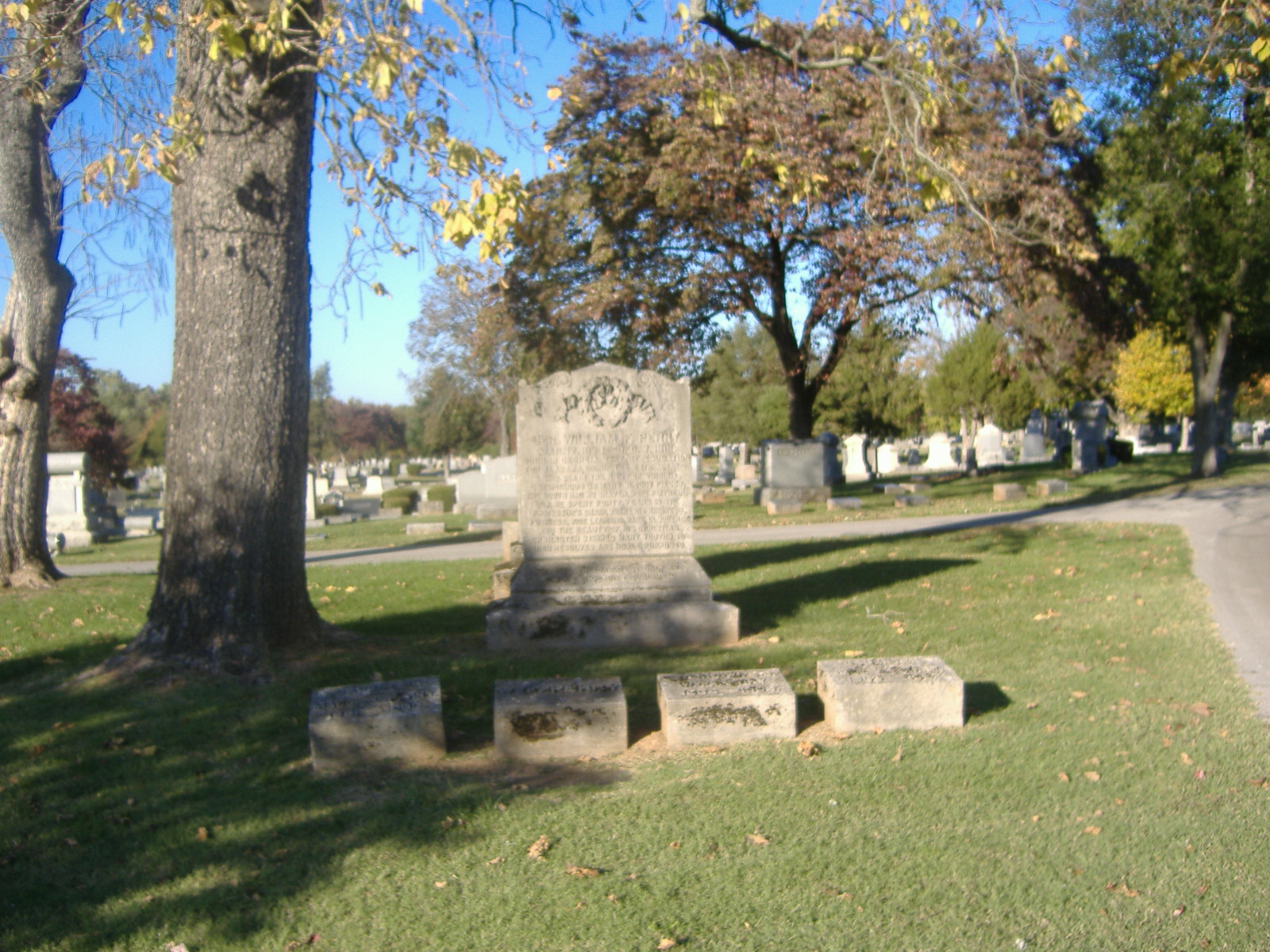
36°59′48″N 86°25′50″W / 36.996667°N 86.430556°WBowling Green 15 Confederate Monument of Bowling Green 
July 17, 1997 Fairview Cemetery, north of the junction of KY 234 and Collette Ln.
36°59′40″N 86°25′15″W / 36.994444°N 86.420833°WBowling Green 16 Peyton Cooke House December 18, 1979 Off U.S. Route 31W
37°03′21″N 86°15′50″W / 37.055833°N 86.263889°WOakland 17 Curd-Moss House November 26, 1980 Off U.S. Route 68
36°54′01″N 86°34′34″W / 36.900278°N 86.576111°WBowling Green 18 A.C. Davidson House November 26, 1980 West of Leayou Rd.
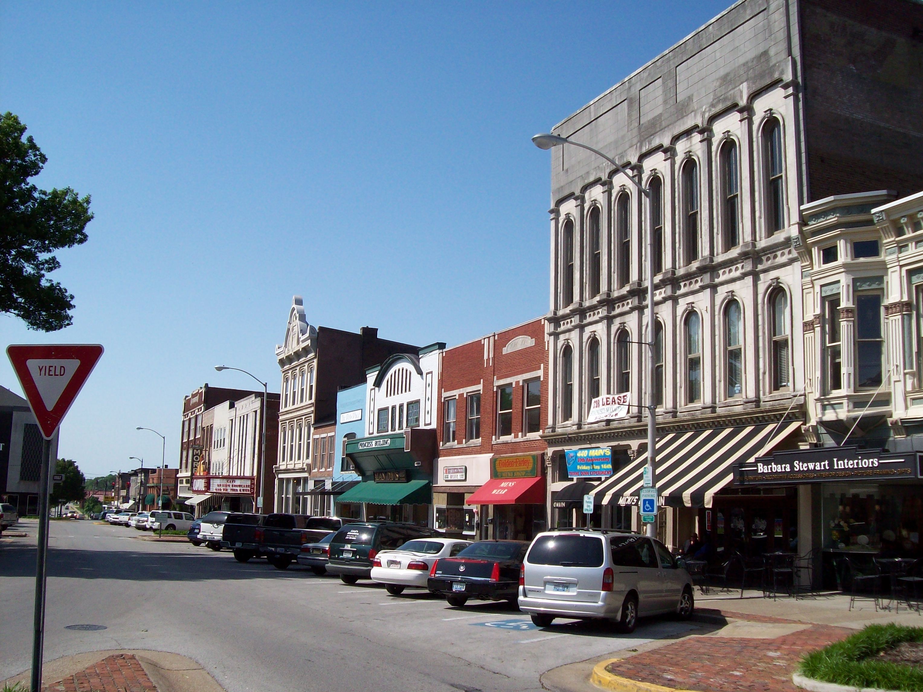
36°51′01″N 86°21′38″W / 36.850278°N 86.360556°WBowling Green 19 Downtown Commercial District 
December 18, 1979 Roughly bounded by Adams and State Sts., 8th and 10th Aves.
36°59′37″N 86°26′31″W / 36.993611°N 86.441944°WBowling Green 20 Burton Memorial Baptist Church 
December 18, 1979 4377 Cemetery Rd.
36°57′55″N 86°22′32″W / 36.965278°N 86.375556°WBowling Green Originally Drakes Creek Baptist Church, renamed in 1911 21 Dunklau Site (15WA374; 15WA380) December 5, 1985 Address Restricted Hadley 22 Willis Ennis House December 18, 1979 Beech Bend Rd.
37°01′19″N 86°24′41″W / 37.021944°N 86.411389°WPlum Springs 23 W.H. Everhardt House December 18, 1979 1223 College St.
36°59′27″N 86°26′47″W / 36.990833°N 86.446389°WBowling Green 24 James F. Ewing House December 18, 1979 Cemetery Rd.
36°59′20″N 86°25′26″W / 36.988889°N 86.423889°WBowling Green 25 Fairview Methodist Church December 18, 1979 KY 526
37°02′17″N 86°20′37″W / 37.038056°N 86.343611°WOakland 26 First Colored Baptist Church December 18, 1979 340 State St.
36°59′48″N 86°26′01″W / 36.996667°N 86.433611°WBowling Green 27 John Jackson Ford House December 18, 1979 Off U.S. Route 31W
37°04′07″N 86°13′39″W / 37.068611°N 86.2275°WSmiths Grove 28 Fort C.F. Smith December 5, 1984 E. Main St.
36°59′18″N 86°26′15″W / 36.988333°N 86.4375°WBowling Green 29 Fort Lytle December 5, 1984 Western Kentucky University
36°59′16″N 86°27′09″W / 36.987778°N 86.4525°WBowling Green 30 Fort Webb December 5, 1984 Country Club Dr.
37°01′18″N 86°26′01″W / 37.021667°N 86.433611°WBowling Green 31 William Gossom House December 18, 1979 U.S. Route 31W
37°00′53″N 86°22′46″W / 37.014722°N 86.379444°WPlum Springs 32 Grider House December 18, 1979 1320 Park St.
36°59′07″N 86°26′42″W / 36.985278°N 86.445°WBowling Green 33 Tobias Grider House December 18, 1979 864A Fairview Ave.
36°59′31″N 86°25′50″W / 36.991944°N 86.430556°WBowling Green 34 Hall House December 18, 1979 104 W. Main St.
36°59′54″N 86°26′44″W / 36.998333°N 86.445556°WBowling Green 35 The Hardcastle Store November 10, 2011 7286 Cemetery Rd.
36°56′42″N 86°19′56″W / 36.945072°N 86.332183°WBowling Green vicinity 36 James Hays House December 18, 1979 U.S. Route 68 and KY 259
37°01′51″N 86°08′28″W / 37.030833°N 86.141111°WHays 37 Health Buildings-Gymnasium December 18, 1979 Normal Dr., Western Kentucky University campus
36°59′10″N 86°27′08″W / 36.986111°N 86.452222°WBowling Green 38 Heating Plant 
December 18, 1979 Dogwood Dr., Western Kentucky University campus
36°59′14″N 86°27′21″W / 36.987222°N 86.455833°WBowling Green 39 Hines House 
December 18, 1979 1103 Adams St.
36°59′43″N 86°26′51″W / 36.995278°N 86.4475°WBowling Green 40 Home Economics Building December 18, 1979 State St., Western Kentucky University campus
36°59′12″N 86°27′05″W / 36.986667°N 86.451389°WBowling Green 41 Horse Shoe Camp November 18, 1997 8241 Louisville Rd.
37°02′52″N 86°19′08″W / 37.047778°N 86.318889°WBowling Green 42 Elouise B. Houchens Center for Women 
December 18, 1979 1115 Adams St.
36°59′41″N 86°26′53″W / 36.994722°N 86.448056°WBowling Green 43 Industrial Arts Building December 18, 1979 State St., Western Kentucky University campus
36°59′10″N 86°27′05″W / 36.986111°N 86.451389°WBowling Green 44 Ironwood July 2, 1973 Old Richardsville Rd.
37°01′17″N 86°27′13″W / 37.021389°N 86.453611°WBowling Green 45 J.C. Joggers House December 18, 1979 East of Pondsville
36°59′51″N 86°09′35″W / 36.9975°N 86.159722°WPondsville 46 James Kelley House December 18, 1979 U.S. Route 68
36°57′23″N 86°37′00″W / 36.956389°N 86.616667°WBowling Green 47 Kentucky Building December 18, 1979 Russellville Rd., Western Kentucky University campus
36°59′19″N 86°27′16″W / 36.988611°N 86.454444°WBowling Green 48 Kinlock December 18, 1979 1.5 miles north of Bowling Green
37°00′48″N 86°27′15″W / 37.013333°N 86.454167°WBowling Green 49 Jesse Kirby Springhouse January 8, 1987 Off U.S. Route 231 on Love Howell Rd.
36°53′18″N 86°23′51″W / 36.888333°N 86.3975°WBowling Green 50 Lost River Archeological Cave June 18, 1975 Address Restricted Bowling Green 51 Louisville and Nashville Railroad Station 
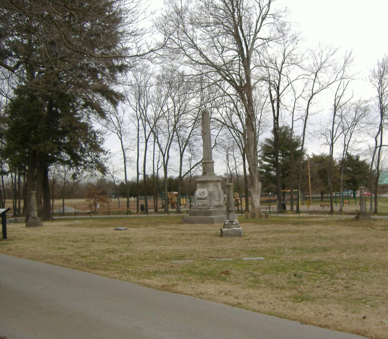
December 18, 1979 Kentucky St.
37°00′00″N 86°26′17″W / 37.0°N 86.438056°WBowling Green 52 Magnolia Street Historic District November 16, 1989 Magnolia St. between Broadway and Tenth St.
36°58′56″N 86°26′13″W / 36.982222°N 86.436944°WBowling Green 53 Merritt-Hardin House December 18, 1979 U.S. Route 31W
36°52′27″N 86°31′44″W / 36.874167°N 86.528889°WBowling Green 54 Jesse Middleton House December 18, 1979 Tuckertown Rd.
37°04′11″N 86°16′13″W / 37.069722°N 86.270278°WOakland 55 Milliken Building February 3, 2010 1039 College St.
36°59′33″N 86°26′38″W / 36.992403°N 86.443833°WBowling Green 56 Modern Automotive District September 15, 2006 538, 600, and 601 State St.
36°59′46″N 86°26′17″W / 36.996111°N 86.438056°WBowling Green 57 Maria Moore House June 20, 1972 801 State St.
36°59′37″N 86°26′24″W / 36.993611°N 86.44°WBowling Green 58 Mount Olivet Cumberland Presbyterian Church December 18, 1979 KY 526
37°03′05″N 86°22′48″W / 37.051389°N 86.38°WBowling Green 59 Samuel Murrell House March 26, 1976 8 miles northeast of Bowling Green on 31W
37°03′33″N 86°17′47″W / 37.059167°N 86.296389°WBowling Green 60 William P. Neale House November 26, 1980 North of Woodburn
36°52′14″N 86°30′53″W / 36.870556°N 86.514722°WWoodburn 61 Newton-Kemp Houses December 18, 1979 804-806 Chestnut St.
36°59′32″N 86°26′16″W / 36.992222°N 86.437778°WBowling Green 62 Nine Hearths December 18, 1979 1244 Park St.
36°59′26″N 86°26′47″W / 36.990556°N 86.446389°WBowling Green 63 Oakland-Freeport Historic District August 2, 2004 Vine, Young, Lee, Mills, Rasdall, Church, Main, Oakland, Kelly, Burnett, Oakland-Smiths Grove, Cooke, Grimes, and Mansfield Sts.
37°02′16″N 86°15′07″W / 37.037778°N 86.251944°WOakland 64 Old Log Church December 18, 1979 West of Riverside
37°09′37″N 86°33′16″W / 37.160278°N 86.554444°WRiverside 65 William F. Perry Monument 
July 17, 1997 Fairview Cemetery, north of the junction of KY 234 and Collette Ln.
36°59′36″N 86°25′17″W / 36.993333°N 86.421389°WBowling Green 66 Pioneer Log Cabin August 4, 2004 Kentucky St., near its junction with University Dr.
36°59′26″N 86°27′20″W / 36.990556°N 86.455556°WBowling Green 67 Polk House December 18, 1979 Ring Rd.
36°50′32″N 86°31′29″W / 36.842222°N 86.524722°WWoodburn 68 President's Home December 18, 1979 State St., Western Kentucky University campus
36°59′16″N 86°27′13″W / 36.987778°N 86.453611°WBowling Green 69 Rauscher House July 12, 1978 818 Adams St.
36°59′50″N 86°26′37″W / 36.997222°N 86.443611°WBowling Green 70 Richardsville Road Bridge November 26, 1980 Spans the Barren River
37°01′14″N 86°26′51″W / 37.020556°N 86.4475°WBowling Green 71 Riverview 
February 23, 1972 Hobson Grove Park at end of Main St.
37°00′44″N 86°27′35″W / 37.012222°N 86.459722°WBowling Green 72 Dr. William Robb House December 18, 1979 Market St.
36°50′26″N 86°31′45″W / 36.840556°N 86.529167°WWoodburn 73 St. James Apartments August 2, 1984 1133 Chestnut St.
36°59′24″N 86°26′34″W / 36.99°N 86.442778°WBowling Green 74 St. Joseph Roman Catholic Church July 3, 1975 430 Church St.
37°00′06″N 86°26′49″W / 37.001667°N 86.446944°WBowling Green 75 St. Joseph's District November 26, 1980 Roughly bounded by Gilbert and Potter Sts., Church Ave., and Brownslock Rd.
37°00′09″N 86°26′57″W / 37.0025°N 86.449167°WBowling Green 76 Edward B. Seeley House December 18, 1979 Beech Bend Rd.
37°00′45″N 86°25′32″W / 37.0125°N 86.425556°WPlum Springs 77 Shake Rag Historic District August 18, 2000 Roughly bounded by the U.S. Route 31W bypass, Chestnut St., E. 5th Ave., and College St.
36°59′50″N 86°26′02″W / 36.997222°N 86.433889°WBowling Green 78 Moses Shobe House December 18, 1979 U.S. Route 31W
37°04′56″N 86°13′26″W / 37.082222°N 86.223889°WSmiths Grove 79 John Sloss House December 18, 1979 Old Springfield Rd.
36°50′49″N 86°35′12″W / 36.846944°N 86.586667°WBowling Green 80 Smiths Grove Baptist Church December 18, 1979 Main and 5th Sts.
37°03′24″N 86°12′27″W / 37.056667°N 86.2075°WSmiths Grove 81 Smiths Grove District December 18, 1979 1st and Main Sts.; also roughly bounded by Smiths Grove Cemetery, the railroad line, Hedge St., and Kentucky St.
37°03′09″N 86°12′29″W / 37.0525°N 86.208056°WSmiths Grove Second group of addresses represents a boundary increase 82 Smiths Grove Presbyterian Church December 18, 1979 College and 2nd Sts.
37°03′13″N 86°12′26″W / 37.053611°N 86.207222°WSmiths Grove 83 Perry Snell Hall December 18, 1979 State St., Western Kentucky University campus
36°59′11″N 86°26′55″W / 36.986389°N 86.448611°WBowling Green 84 Stadium 
December 18, 1979 Russellville Rd., Western Kentucky University campus
36°59′12″N 86°27′11″W / 36.986667°N 86.453056°WBowling Green 85 Standard Oil Company Filling Station August 5, 2010 638 College St.
36°59′46″N 86°26′18″W / 36.996111°N 86.438333°WBowling Green 86 Sterrett House December 18, 1979 KY 526
37°03′13″N 86°12′26″W / 37.053611°N 86.207222°WPlum Springs 87 Underwood-Jones House July 7, 1978 506 State St.
36°59′44″N 86°26′07″W / 36.995556°N 86.435278°WBowling Green 88 Upper East Main Street District December 18, 1979 E. Main and Elm Sts.
36°59′28″N 86°26′18″W / 36.991111°N 86.438333°WBowling Green 89 Van Meter Hall 
December 18, 1979 15th St., Western Kentucky University campus
36°59′17″N 86°27′08″W / 36.988056°N 86.452222°WBowling Green 90 Walnut Lawn October 20, 1983 West of Bowling Green on Morgantown Rd.
36°59′34″N 86°29′44″W / 36.992778°N 86.495556°WBowling Green 91 Andrew James Wardlaw House December 18, 1979 Off U.S. Route 31W
37°02′45″N 86°18′12″W / 37.045833°N 86.303333°WOakland 92 Warren County Courthouse August 2, 1977 429 E. 10th St.
36°59′33″N 86°26′34″W / 36.9925°N 86.442778°WBowling Green 93 West Hall December 18, 1979 Virginia Garrett Ave., Western Kentucky University campus
36°59′14″N 86°27′15″W / 36.987222°N 86.454167°WBowling Green 94 Gordon Wilson Hall December 18, 1979 15th St., Western Kentucky University campus
36°59′17″N 86°27′06″W / 36.988056°N 86.451667°WBowling Green 95 J.L. Wright House December 18, 1979 1st St.
37°03′10″N 86°12′33″W / 37.052778°N 86.209167°WSmiths Grove 96 Young's Ferry House December 18, 1979 Ferry Rd.
37°09′10″N 86°28′03″W / 37.152778°N 86.4675°WBowling Green See also
- List of National Historic Landmarks in Kentucky
- National Register of Historic Places listings in Kentucky
References
- ^ The latitude and longitude information provided in this table was derived originally from the National Register Information System, which has been found to be fairly accurate for about 99% of listings. For about 1% of NRIS original coordinates, experience has shown that one or both coordinates are typos or otherwise extremely far off; some corrections may have been made. A more subtle problem causes many locations to be off by up to 150 yards, depending on location in the country: most NRIS coordinates were derived from tracing out latitude and longitudes off of USGS topographical quadrant maps created under the North American Datum of 1927, which differs from the current, highly accurate WGS84 GPS system used by Google maps. Chicago is about right, but NRIS longitudes in Washington are higher by about 4.5 seconds, and are lower by about 2.0 seconds in Maine. Latitudes differ by about 1.0 second in Florida. Some locations in this table may have been corrected to current GPS standards.
- ^ "National Register of Historic Places: Weekly List Actions". National Park Service, United States Department of the Interior. Retrieved on November 10, 2011.
- ^ Numbers represent an ordering by significant words. Various colorings, defined here, differentiate National Historic Landmark sites and National Register of Historic Places Districts from other NRHP buildings, structures, sites or objects.
U.S. National Register of Historic Places Topics Lists by states Alabama • Alaska • Arizona • Arkansas • California • Colorado • Connecticut • Delaware • Florida • Georgia • Hawaii • Idaho • Illinois • Indiana • Iowa • Kansas • Kentucky • Louisiana • Maine • Maryland • Massachusetts • Michigan • Minnesota • Mississippi • Missouri • Montana • Nebraska • Nevada • New Hampshire • New Jersey • New Mexico • New York • North Carolina • North Dakota • Ohio • Oklahoma • Oregon • Pennsylvania • Rhode Island • South Carolina • South Dakota • Tennessee • Texas • Utah • Vermont • Virginia • Washington • West Virginia • Wisconsin • WyomingLists by territories Lists by associated states Other Municipalities and communities of Warren County, Kentucky Cities  Categories:
- National Register of Historic Places in Kentucky by county
- Warren County, Kentucky
-


Wikimedia Foundation. 2010.