- National Register of Historic Places listings in Carroll County, Kentucky
-
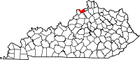
 Location of Carroll County in Kentucky
This is a list of the National Register of Historic Places listings in Carroll County, Kentucky. It is intended to be a complete list of the properties and districts on the National Register of Historic Places in Carroll County, Kentucky, United States. The locations of National Register properties and districts for which the latitude and longitude coordinates are included below, may be seen in a Google map.[1]
There are approximately 11 properties and districts listed on the National Register in the county.
-
- This National Park Service list is complete through NPS recent listings posted November 10, 2011.[2]
Listings county-wide
[3] Landmark name Image Date listed Location City or town Summary 1 Paschal Todd Baker House November 25, 1980 406 Highland Ave.
38°40′51″N 85°10′53″W / 38.680833°N 85.181389°WCarrollton 2 Gen. William O. Butler House May 28, 1976 Highland Ave.
38°40′54″N 85°10′29″W / 38.681667°N 85.174722°WCarrollton 3 Carrollton Historic District 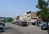
November 12, 1982 Roughly bounded by Main, Polk, 2nd, 7th, and both sides of Highland Ave. to 11th St.
38°40′45″N 85°10′40″W / 38.679167°N 85.177778°WCarrollton 4 Ghent Historic District August 25, 1983 U.S. Route 42, Fishing, Ann, Main Cross, Ferry, Water, Union, and Liberty Sts.
38°44′11″N 85°03′29″W / 38.736389°N 85.058056°WGhent 5 Grass Hills August 22, 1975 5 miles southeast of Ghent on KY 47 at Interstate 71
38°40′21″N 85°00′26″W / 38.6725°N 85.007222°WGhent 6 Hunter's Bottom Historic District August 11, 1976 West of Carrollton
38°43′23″N 85°17′31″W / 38.723056°N 85.291944°WCarrollton 7 Richard Masterson House July 1, 1975 E of the junction of U.S. Routes 42 and 227
38°41′20″N 85°09′06″W / 38.688889°N 85.151667°WCarrollton 8 Henry Ogburn House January 8, 1987 Off U.S. Route 42
38°41′30″N 85°07′59″W / 38.691667°N 85.133056°WCarrollton 9 Richlawn Farm March 24, 2000 1705 Highland Ave.
38°41′15″N 85°09′16″W / 38.6875°N 85.154444°WCarrollton 10 Stone House on Kentucky River January 8, 1987 KY 55
38°40′24″N 85°11′36″W / 38.673333°N 85.193333°WPrestonville 11 Turpin House December 2, 1977 Butler State Park off 11th St.
38°40′09″N 85°09′56″W / 38.669167°N 85.165556°WCarrollton See also
- List of National Historic Landmarks in Kentucky
- National Register of Historic Places listings in Kentucky
References
- ^ The latitude and longitude information provided in this table was derived originally from the National Register Information System, which has been found to be fairly accurate for about 99% of listings. For about 1% of NRIS original coordinates, experience has shown that one or both coordinates are typos or otherwise extremely far off; some corrections may have been made. A more subtle problem causes many locations to be off by up to 150 yards, depending on location in the country: most NRIS coordinates were derived from tracing out latitude and longitudes off of USGS topographical quadrant maps created under the North American Datum of 1927, which differs from the current, highly accurate WGS84 GPS system used by Google maps. Chicago is about right, but NRIS longitudes in Washington are higher by about 4.5 seconds, and are lower by about 2.0 seconds in Maine. Latitudes differ by about 1.0 second in Florida. Some locations in this table may have been corrected to current GPS standards.
- ^ "National Register of Historic Places: Weekly List Actions". National Park Service, United States Department of the Interior. Retrieved on November 10, 2011.
- ^ Numbers represent an ordering by significant words. Various colorings, defined here, differentiate National Historic Landmark sites and National Register of Historic Places Districts from other NRHP buildings, structures, sites or objects.
U.S. National Register of Historic Places Topics Lists by states Alabama • Alaska • Arizona • Arkansas • California • Colorado • Connecticut • Delaware • Florida • Georgia • Hawaii • Idaho • Illinois • Indiana • Iowa • Kansas • Kentucky • Louisiana • Maine • Maryland • Massachusetts • Michigan • Minnesota • Mississippi • Missouri • Montana • Nebraska • Nevada • New Hampshire • New Jersey • New Mexico • New York • North Carolina • North Dakota • Ohio • Oklahoma • Oregon • Pennsylvania • Rhode Island • South Carolina • South Dakota • Tennessee • Texas • Utah • Vermont • Virginia • Washington • West Virginia • Wisconsin • WyomingLists by territories Lists by associated states Other Municipalities and communities of Carroll County, Kentucky Cities Carrollton | Ghent | Prestonville | Sanders | Worthville
 Categories:
- National Register of Historic Places in Kentucky by county
- Carroll County, Kentucky
-


Wikimedia Foundation. 2010.