- National Register of Historic Places listings in Clark County, Kentucky
-
 Location of Clark County in Kentucky
This is a list of the National Register of Historic Places listings in Clark County, Kentucky.
This is intended to be a complete list of the properties and districts on the National Register of Historic Places in Clark County, Kentucky, United States. The locations of National Register properties and districts for which the latitude and longitude coordinates are included below, may be seen in a Google map.[1]
There are 66 properties and districts listed on the National Register in the county.
-
- This National Park Service list is complete through NPS recent listings posted November 10, 2011.[2]
Current listings
[3] Landmark name Image Date listed Location City or town Summary 1 Antioch Christian Church August 1, 1979 Off Muddy Creek Rd. at Four Mile Creek and Stone Branch
37°54′28″N 84°10′06″W / 37.907778°N 84.168333°WWinchester 2 Boone Creek Rural Historic District August 19, 1994 Roughly bounded by Interstate 75, Cleveland Rd., Athens-Boonesboro Rd. and Grimes Rd.
6°38′27″N 87°43′27″W / 6.640833°N 87.724167°WLexington 3 Boot Hill Farm March 1, 1985 Athens-Boonesboro Pike (KY 418
37°55′53″N 84°20′22″W / 37.931389°N 84.339444°WAthens 4 Brock House August 1, 1979 Off Red River Rd.
37°52′09″N 84°06′11″W / 37.869167°N 84.103056°WBloomingdale 5 Brown-Proctoria Hotel 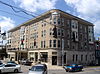
July 29, 1977 Main St. and Lexington Ave.
37°59′28″N 84°10′42″W / 37.991111°N 84.178333°WWinchester 6 Capt. Robert V. Bush House August 1, 1979 Combs Ferry Rd.
37°58′05″N 84°17′22″W / 37.968056°N 84.289444°WBecknerville 7 W. Bush-Dykes House August 1, 1979 U.S. Route 227
37°55′02″N 84°15′26″W / 37.917222°N 84.257222°WForest Grove 8 Bybee House August 1, 1979 Bybee Rd.
37°54′55″N 84°11′05″W / 37.915278°N 84.184722°WWinchester 9 Henry W. Calmes House August 1, 1979 U.S. Route 227
37°58′45″N 84°18′51″W / 37.979167°N 84.314167°WWinchester 10 Tarleton Chiles House August 1, 1979 Jones Nursery Rd.
37°57′33″N 84°17′18″W / 37.959167°N 84.288333°WBecknerville 11 Civil War Fort at Boonesboro June 18, 2003 0.6 miles north of Ford, west of Fort Hampton Rd.
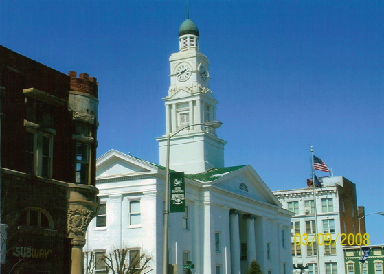
37°53′24″N 84°15′32″W / 37.89°N 84.258889°WFord 12 Clark County Court House 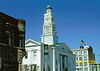
August 7, 1974 Main St.
37°59′34″N 84°10′41″W / 37.992778°N 84.178056°WWinchester 13 Gov. James A. Clark Mansion 
June 13, 1974 Burns Ave. and Belmont St.
37°59′20″N 84°11′16″W / 37.988889°N 84.187778°WWinchester 14 William Clinkenbeard House November 20, 1980 Old Paris Pike
38°02′48″N 84°10′42″W / 38.046667°N 84.178333°WWinchester 15 Colby Tavern August 1, 1979 Junction of Colby and Becknerville Rds.
37°59′34″N 84°15′51″W / 37.992778°N 84.264167°WWinchester 16 Corinth Christian Methodist Episcopal Church July 11, 2007 1180 L E Junction Rd.
37°59′54″N 84°03′30″W / 37.998333°N 84.058333°WWinchester 17 Couchman House August 1, 1979 Off Old Boonesboro Rd.
37°57′20″N 84°10′26″W / 37.955556°N 84.173889°WWinchester 18 Frances Cullom, Jr. House August 1, 1979 Muddy Creek Rd.
37°55′08″N 84°09′50″W / 37.918889°N 84.163889°WWinchester 19 Elkin House August 1, 1979 Off U.S. Route 227
37°56′19″N 84°13′17″W / 37.938611°N 84.221389°WWinchester 20 Achilles Eubank House August 1, 1979 Elkin Rd.
37°54′25″N 84°12′37″W / 37.906944°N 84.210278°WWinchester 21 Jesse Fishback House August 1, 1979 Off Combs Ferry Rd.
37°58′50″N 84°18′56″W / 37.980556°N 84.315556°WBecknerville 22 John Gibbs House August 1, 1979 Fox-Quisenberry Rd.
37°56′31″N 84°04′00″W / 37.941944°N 84.066667°WPilotview 23 David Gist House August 1, 1979 Stoner Rd.
38°05′01″N 84°06′47″W / 38.083611°N 84.113056°WWinchester 24 Strauder Goff House August 1, 1979 Off Van Meter Rd.
38°02′48″N 84°11′54″W / 38.046667°N 84.198333°WWinchester 25 Goshen Primitive Baptist Church August 1, 1979 Goshen Rd.
38°01′08″N 84°04′15″W / 38.018889°N 84.070833°WWinchester 26 Nathaniel Haggard House August 1, 1979 Off New Boonesborough Rd.
37°57′35″N 84°12′18″W / 37.959722°N 84.205°WWinchester 27 Jesse Hampton House August 1, 1979 Bybee Rd.
37°55′05″N 84°11′02″W / 37.918056°N 84.183889°WWinchester 28 Gen. Thomas Hart House August 1, 1979 Ecton Rd.
38°00′10″N 84°09′13″W / 38.002778°N 84.153611°WWinchester 29 William Hickman House November 24, 1982 31 W. Hickman St.
37°59′27″N 84°10′48″W / 37.990833°N 84.18°WWinchester 30 Hodgkins House August 1, 1979 Old Boonesborough Rd.
37°55′51″N 84°14′07″W / 37.930833°N 84.235278°WWinchester 31 Dailey-Milton Holliday House August 1, 1979 Jones Nursery Rd.
37°57′00″N 84°18′42″W / 37.95°N 84.311667°WBecknerville 32 Hollywood Springs August 1, 1979 Off Kiddville Rd.
37°56′55″N 83°59′10″W / 37.948611°N 83.986111°WKiddville 33 Hood-Tucker House January 4, 2007 19 French Ave.
37°59′10″N 84°10′43″W / 37.986111°N 84.178611°WWinchester 34 Indian Fort Earthworks (15CK7) November 14, 1985 Address Restricted Goffs Corners 35 Lampton House August 1, 1979 Muddy Creek Rd.
37°56′57″N 84°08′49″W / 37.949167°N 84.146944°WWinchester 36 Alpheus Lewis House August 1, 1979 Off Wades Mill Rd.
38°04′32″N 84°06′54″W / 38.075556°N 84.115°WWinchester 37 Martin House August 1, 1979 On Lower Howard's Creek
37°55′44″N 84°16′33″W / 37.928889°N 84.275833°WHootentown 38 Maj. John Martin House April 29, 1982 Basin Springs Rd.
37°59′23″N 84°17′14″W / 37.989722°N 84.287222°WPine Grove 39 Martin-Holder-Bush-Hampton Mill November 20, 1980 Address Restricted Winchester 40 Middle Reaches of Boone Creek Rural Historic District May 31, 1996 Roughly bounded by U.S. Route 421, Jones Nursery, Coombs Ferry, Sulpher Well Rds., and U.S. Route 25
37°57′34″N 84°19′17″W / 37.959444°N 84.321389°WLexington 41 Mound Hill Archeological Site August 25, 1978 Address Restricted Winchester 42 Oliver School August 4, 2004 30 Oliver St.
37°59′44″N 84°10′47″W / 37.995556°N 84.179722°WWinchester 43 Owen-Gay Farm March 13, 1997 Gay Rd., junction with Donaldson Rd. at the Bourbon County line
38°06′14″N 84°06′43″W / 38.103889°N 84.111944°WWinchester 44 Parrish Place August 1, 1979 Todd-Colby Rd.
37°59′31″N 84°19′14″W / 37.991944°N 84.320556°WPine Grove 45 Col. Edmund Pendleton House August 1, 1979 Van Meter Rd.
38°03′24″N 84°15′09″W / 38.056667°N 84.2525°WClintonville 46 Maj. Walter Preston House August 1, 1979 Basin Springs Rd.
37°58′45″N 84°17′19″W / 37.979167°N 84.288611°WBecknerville 47 Providence Baptist Church 
May 13, 1976 6 miles southwest of Winchester off KY 627
37°56′15″N 84°14′45″W / 37.9375°N 84.245833°WWinchester 48 W. Pruett House November 20, 1980 Ecton Rd.
38°00′40″N 84°02′44″W / 38.011111°N 84.045556°WWinchester 49 J. Quisenberry House August 1, 1979 Quisenberry Rd.
37°55′43″N 84°15′05″W / 37.928611°N 84.251389°WForest Grove 50 Joel Quisenberry House August 1, 1979 Flanagan Station Rd.
37°56′06″N 84°12′57″W / 37.935°N 84.215833°WWinchester 51 Redmond House August 1, 1979 Off U.S. Route 60
38°01′31″N 84°03′42″W / 38.025278°N 84.061667°WWinchester 52 Robert Scobee House November 20, 1980 Off U.S. Route 60
38°03′16″N 84°05′28″W / 38.054444°N 84.091111°WWinchester 53 South Park Neighborhood June 18, 2008 Roughly bounded by Hickman St., an alley east of Kentucky St., the rear of properties facing Highland St., and French Ave.
37°59′16″N 84°10′56″W / 37.987778°N 84.182222°WWinchester 54 Springhill February 17, 1978 North of Winchester on Colby Rd.
38°00′30″N 84°17′11″W / 38.008333°N 84.286389°WWinchester 55 Stipp House November 20, 1980 Van Meter Rd.
38°03′41″N 84°14′58″W / 38.061389°N 84.249444°WWinchester 56 F. Taylor Mill November 20, 1980 Address Restricted Winchester 57 William Taylor House August 1, 1979 Lower Howard's Creek
37°56′16″N 84°15′52″W / 37.937778°N 84.264444°WBecknerville 58 Stanley F. Tebbs House August 1, 1979 Todd's Rd.
38°00′02″N 84°17′04″W / 38.000556°N 84.284444°WPine Grove 59 Thomson Neighborhood District January 17, 1992 Roughly bounded by S. Main St., Moundale Ave., Boone Ave., S. Maple St. and W. Hickman St.
37°59′16″N 84°10′56″W / 37.987778°N 84.182222°WWinchester 60 Upper Reaches of Boone Creek Rural Historic District November 27, 2009 Upper Boone Creek vicinity Winchester 61 Van Meter Distillery August 1, 1979 Van Meter Rd.
38°02′16″N 84°12′52″W / 38.037778°N 84.214444°WWinchester 62 Victory Heights Elementary School August 4, 2004 160 Maryland Ave.
38°00′05″N 84°11′39″W / 38.001389°N 84.194167°WWinchester 63 Vinewood August 12, 1977 4 miles northeast of Winchester on U.S. Route 60
38°02′07″N 84°07′35″W / 38.035278°N 84.126389°WWinchester 64 Wade Farmstead August 1, 1979 Donaldson Rd.
38°06′25″N 84°05′07″W / 38.106944°N 84.085278°WWinchester 65 Winchester Downtown Commercial District 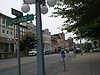
April 28, 1982 Roughly bounded by railroad tracks, KY 627, and Maple and Highland Sts.
37°59′34″N 84°10′38″W / 37.992778°N 84.177222°WWinchester 66 Woodford-Fishback-Venable Farm August 1, 1979 5696 Combs Ferry Rd.
37°56′21″N 84°17′05″W / 37.93914°N 84.28461°WWinchester See also
- List of National Historic Landmarks in Kentucky
- National Register of Historic Places listings in Kentucky
References
- ^ The latitude and longitude information provided in this table was derived originally from the National Register Information System, which has been found to be fairly accurate for about 99% of listings. For about 1% of NRIS original coordinates, experience has shown that one or both coordinates are typos or otherwise extremely far off; some corrections may have been made. A more subtle problem causes many locations to be off by up to 150 yards, depending on location in the country: most NRIS coordinates were derived from tracing out latitude and longitudes off of USGS topographical quadrant maps created under North American Datum of 1927, which differs from the current, highly accurate GPS system used by Google maps. Chicago is about right, but NRIS longitudes in Washington are higher by about 4.5 seconds, and are lower by about 2.0 seconds in Maine. Latitudes differ by about 1.0 second in Florida. Some locations in this table may have been corrected to current GPS standards.
- ^ "National Register of Historic Places: Weekly List Actions". National Park Service, United States Department of the Interior. Retrieved on November 10, 2011.
- ^ Numbers represent an ordering by significant words. Various colorings, defined here, differentiate National Historic Landmark sites and National Register of Historic Places Districts from other NRHP buildings, structures, sites or objects.
U.S. National Register of Historic Places Topics Lists by states Alabama • Alaska • Arizona • Arkansas • California • Colorado • Connecticut • Delaware • Florida • Georgia • Hawaii • Idaho • Illinois • Indiana • Iowa • Kansas • Kentucky • Louisiana • Maine • Maryland • Massachusetts • Michigan • Minnesota • Mississippi • Missouri • Montana • Nebraska • Nevada • New Hampshire • New Jersey • New Mexico • New York • North Carolina • North Dakota • Ohio • Oklahoma • Oregon • Pennsylvania • Rhode Island • South Carolina • South Dakota • Tennessee • Texas • Utah • Vermont • Virginia • Washington • West Virginia • Wisconsin • WyomingLists by territories Lists by associated states Other  Category:National Register of Historic Places •
  Portal:National Register of Historic Places
Municipalities and communities of Clark County, Kentucky County seat: Winchester City 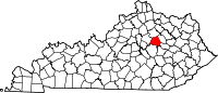
Unincorporated
communitiesCategories:- National Register of Historic Places in Kentucky by county
- Clark County, Kentucky
-


Wikimedia Foundation. 2010.