- National Register of Historic Places listings in McCracken County, Kentucky
-
 Location of McCracken County in Kentucky
This is a list of the National Register of Historic Places listings in McCracken County, Kentucky. It is intended to be a complete list of the properties and districts on the National Register of Historic Places in McCracken County, Kentucky, United States. The locations of National Register properties and districts for which the latitude and longitude coordinates are included below, may be seen in a Google map.[1]
There are approximately 26 properties and districts listed on the National Register in the county.
-
- This National Park Service list is complete through NPS recent listings posted November 10, 2011.[2]
Listings county-wide
[3] Landmark name Image Date listed Location City or town Summary 1 Artelia Anderson Hall May 26, 1983 1400 H.C. Mathis Dr.
37°03′34″N 88°34′51″W / 37.059444°N 88.580833°WPaducah 2 Anderson-Smith House 
March 1, 1984 Lone Oak Rd.
37°03′03″N 88°39′10″W / 37.050833°N 88.652778°WPaducah 3 The Angles July 19, 1976 Alben W. Barkley Dr. near 40th St.
37°03′35″N 88°38′49″W / 37.059722°N 88.646944°WPaducah 4 Archeological Site 15McN51 
July 11, 1985 Address Restricted Paducah 5 Confederate Monument in Paducah 
July 17, 1997 Oak Grove Cemetery, west of the junction of Park Ave. and 13th St.
37°05′10″N 88°37′24″W / 37.086111°N 88.623333°WPaducah 6 Grace Episcopal Church March 16, 1976 820 Broadway
37°05′03″N 88°36′13″W / 37.084167°N 88.603611°WPaducah 7 Home of the Friendless November 15, 2000 1335 Burnett St.
37°05′15″N 88°37′02″W / 37.0875°N 88.617222°WPaducah 8 Hotel Irvin Cobb 
August 24, 1978 Broadway and 6th St.
37°05′07″N 88°36′02″W / 37.085278°N 88.600556°WPaducah 9 Hotel Metropolitan April 12, 2002 724 Jackson St.
37°04′45″N 88°35′57″W / 37.079167°N 88.599167°WPaducah 10 Jefferson Street-Fountain Avenue Residential District July 14, 1982 Jefferson and Madison Sts., Broadway, Fountain Ave., and Harahan Blvd.
37°04′46″N 88°37′16″W / 37.079444°N 88.621111°WPaducah 11 Kenmil Place February 11, 2009 4300 Alben Barkley Dr.
37°03′33″N 88°39′01″W / 37.059064°N 88.65027°WPaducah 12 Lincoln School June 23, 1988 S. 8th St., between Ohio and Tennessee Sts.
37°04′40″N 88°35′57″W / 37.077778°N 88.599167°WPaducah 13 Lower Town Neighborhood District March 15, 1982 Roughly bounded by Park Ave., Jefferson, 5th and 9th Sts.
37°05′17″N 88°36′17″W / 37.088056°N 88.604722°WPaducah 14 Market House June 19, 1973 S. 2nd St. between Broadway and Kentucky Ave.
37°05′14″N 88°35′43″W / 37.087222°N 88.595278°WPaducah 15 Masonic Temple December 4, 2002 501-505 S. 7th St.
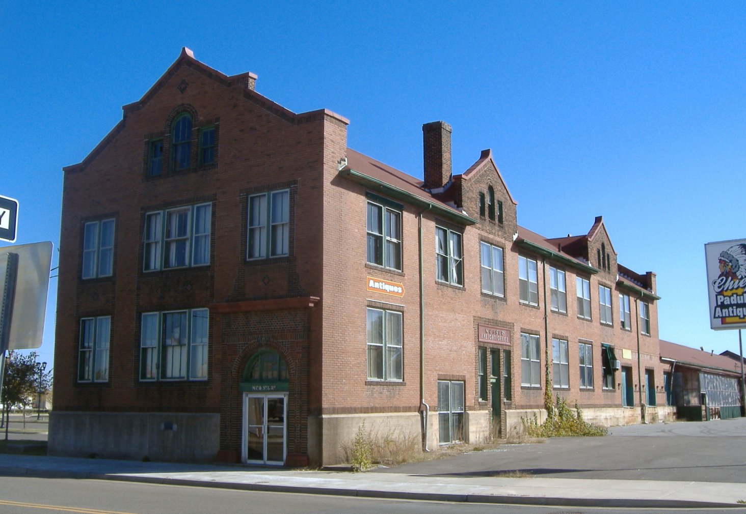
37°04′50″N 88°35′58″W / 37.080556°N 88.599444°WPaducah 16 Nashville, Chattanooga, and St. Louis Railway Office and Freight House 
July 17, 1979 300 S. 3rd St.
37°05′06″N 88°35′42″W / 37.085°N 88.595°WPaducah 17 Paducah Downtown Commercial District 
April 20, 1982 Roughly bounded by 7th, 1st, Clark and Monroe Sts.; roughly bounded by 1st, Clark, 7th, and Monroe Sts.
37°05′14″N 88°35′43″W / 37.087222°N 88.595278°WPaducah Second group of streets is boundary increase 18 Paducah Market House District April 3, 1978 2nd St. between Broadway and Kentucky Ave.
37°05′14″N 88°35′43″W / 37.087222°N 88.595278°WPaducah 19 People's First National Bank and Trust Company Building August 11, 1980 300 Broadway
37°05′13″N 88°35′48″W / 37.086944°N 88.596667°WPaducah 20 Saint Mary Academy Complex March 17, 1987 Bounded by 4th, 5th, Monroe, and Jefferson Sts.
37°05′17″N 88°35′59″W / 37.088056°N 88.599722°WPaducah 21 St. Francis DeSales Roman Catholic Church April 16, 1979 116 S. 6th St.
37°05′08″N 88°36′00″W / 37.085556°N 88.6°WPaducah 22 Augusta Tilghman High School April 3, 1995 401 Walter Jetton Blvd.
37°04′53″N 88°36′11″W / 37.081389°N 88.603056°WPaducah 23 Lloyd Tilghman Memorial 
July 17, 1997 Lange Park, Madison St. between 16th and 19th Sts.
37°04′55″N 88°37′11″W / 37.081944°N 88.619722°WPaducah 24 Tilghman-Woolfolk House 
August 13, 1998 631 Kentucky Ave.
37°05′04″N 88°36′04″W / 37.084444°N 88.601111°WPaducah 25 Union Station School August 19, 2011 3138 Roosevelt St. (also known as Flagman Dr.)[4]
37°02′21″N 88°36′21″W / 37.039167°N 88.605833°WPaducah 26 Mayor David A. Yeiser House March 7, 1973 533 Madison St.
37°05′20″N 88°36′08″W / 37.088889°N 88.602222°WPaducah See also
- List of National Historic Landmarks in Kentucky
- National Register of Historic Places listings in Kentucky
References
- ^ The latitude and longitude information provided in this table was derived originally from the National Register Information System, which has been found to be fairly accurate for about 99% of listings. For about 1% of NRIS original coordinates, experience has shown that one or both coordinates are typos or otherwise extremely far off; some corrections may have been made. A more subtle problem causes many locations to be off by up to 150 yards, depending on location in the country: most NRIS coordinates were derived from tracing out latitude and longitudes off of USGS topographical quadrant maps created under the North American Datum of 1927, which differs from the current, highly accurate WGS84 GPS system used by Google maps. Chicago is about right, but NRIS longitudes in Washington are higher by about 4.5 seconds, and are lower by about 2.0 seconds in Maine. Latitudes differ by about 1.0 second in Florida. Some locations in this table may have been corrected to current GPS standards.
- ^ "National Register of Historic Places: Weekly List Actions". National Park Service, United States Department of the Interior. Retrieved on November 10, 2011.
- ^ Numbers represent an ordering by significant words. Various colorings, defined here, differentiate National Historic Landmark sites and National Register of Historic Places Districts from other NRHP buildings, structures, sites or objects.
- ^ "National Register of Historic Places Registration Form: Union Station School". http://heritage.ky.gov/NR/rdonlyres/B6E007F9-7B47-4F31-ACD0-CECCB04ABB45/0/UnionStationSchoolPaducah.pdf. Retrieved September 4, 2011.
U.S. National Register of Historic Places Topics Lists by states Alabama • Alaska • Arizona • Arkansas • California • Colorado • Connecticut • Delaware • Florida • Georgia • Hawaii • Idaho • Illinois • Indiana • Iowa • Kansas • Kentucky • Louisiana • Maine • Maryland • Massachusetts • Michigan • Minnesota • Mississippi • Missouri • Montana • Nebraska • Nevada • New Hampshire • New Jersey • New Mexico • New York • North Carolina • North Dakota • Ohio • Oklahoma • Oregon • Pennsylvania • Rhode Island • South Carolina • South Dakota • Tennessee • Texas • Utah • Vermont • Virginia • Washington • West Virginia • Wisconsin • WyomingLists by territories Lists by associated states Other Municipalities and communities of McCracken County, Kentucky City 
CDPs Unincorporated
communitiesFootnotes ‡This populated place also has portions in an adjacent county or counties
Categories:- National Register of Historic Places in Kentucky by county
- National Register of Historic Places in McCracken County, Kentucky
-


Wikimedia Foundation. 2010.