- National Register of Historic Places listings in Woodford County, Kentucky
-
 Location of Woodford County in Kentucky
This is a list of the National Register of Historic Places listings in Woodford County, Kentucky.
This is intended to be a complete list of the properties and districts on the National Register of Historic Places in Woodford County, Kentucky, United States. The locations of National Register properties and districts for which the latitude and longitude coordinates are included below, may be seen in a Google map.[1]
There are 81 properties and districts listed on the National Register in the county, of which 1 is a National Historic Landmark.
-
- This National Park Service list is complete through NPS recent listings posted November 10, 2011.[2]
Current listings
[3] Landmark name Image Date listed Location City or town Summary 1 Airy Mount November 15, 1978 Southwest of Versailles off U.S. Route 62
38°01′38″N 84°46′28″W / 38.027222°N 84.774444°WVersailles 2 Alexander Plantation House June 23, 1983 Off Old Frankford Pike
38°08′45″N 84°44′29″W / 38.145833°N 84.741389°WMidway 3 John Allen House June 23, 1983 Off Kentucky Route 169
37°58′40″N 84°41′00″W / 37.977778°N 84.683333°WKeene 4 Archeological Site 15Wd61 June 2, 1982 Address Restricted Nonesuch 5 Arnold-Wooldridge House May 29, 1979 South of Versailles
38°00′21″N 84°45′52″W / 38.005833°N 84.764444°WVersailles 6 Ayres House January 27, 1994 Southern side of U.S. Route 421, less than 0.3 miles east of Drucker's Rd.
38°10′32″N 84°46′26″W / 38.175556°N 84.773889°WMidway 7 Big Sink Rural Historic District January 27, 1994 West of Midway off Interstate 64
38°07′17″N 84°43′17″W / 38.121389°N 84.721389°WVersailles 8 Big Sink Rural Historic District January 27, 1994 West of Midway off Interstate 64
38°07′17″N 84°43′17″W / 38.121389°N 84.721389°WMidway 9 Big Spring Church May 6, 1975 121 Rose Hill St.
38°02′33″N 84°43′56″W / 38.0425°N 84.732222°WVersailles 10 Charles Black Farm February 10, 1989 Faywood Rd.
38°06′18″N 84°38′34″W / 38.105°N 84.642778°WVersailles 11 Edward M. Blackburn House December 5, 1985 Spring Station Rd.
38°09′30″N 84°44′02″W / 38.158333°N 84.733889°WMidway 12 Lucas Broadhead House January 27, 1994 Southwestern corner of the junction of Midway Pike and Aiken Rd.
38°05′41″N 84°43′20″W / 38.094722°N 84.722222°WVersailles 13 Buck Pond February 10, 1989 Paynes Mill Rd.
38°04′00″N 84°41′13″W / 38.066667°N 84.686944°WVersailles 14 Bullock Site March 15, 2005 Address Restricted Versailles 15 Marquis Calmes Tomb February 10, 1989 Paynes Mill Rd.
38°03′32″N 84°40′28″W / 38.058889°N 84.674444°WVersailles 16 Carter House May 2, 1975 110 Morgan St.
38°03′04″N 84°43′48″W / 38.051111°N 84.73°WVersailles 17 Cleveland House April 10, 2007 140 Park St.
38°03′09″N 84°43′55″W / 38.0525°N 84.731944°WVersailles 18 Clifton Country Club November 7, 1995 1190 Buck Run Rd.
38°04′19″N 84°50′17″W / 38.071944°N 84.838056°WVersailles 19 Clifton-McCraken Rural Historic District January 25, 1999 Roughly along Clifton and McCraken Pikes, and Steele Rd.
38°04′26″N 84°47′54″W / 38.073889°N 84.798333°WVersailles 20 Richard Cole Homestead January 27, 1994 Southern side of Leestown Rd., northwest of Midway
38°09′58″N 84°42′32″W / 38.166111°N 84.708889°WMidway 21 Confederate Monument in Versailles 
July 17, 1997 City Cemetery, southeast of the junction of Clifton Rd. and Kentucky Route 33
38°02′57″N 84°43′44″W / 38.049167°N 84.728889°WVersailles 22 Cooper House January 27, 1994 Northern side of Leestown Rd., 0.9 miles east of the Midway exit from Interstate 64
38°09′05″N 84°39′47″W / 38.151389°N 84.663056°WMidway 23 Downtown Versailles Historic District 
September 2, 1975 Both sides of Main St. between Rose Hill Ave. and Green St.
38°03′08″N 84°43′50″W / 38.052222°N 84.730556°WVersailles 24 Joel DuPuy House June 23, 1983 Griers Creek Rd.
38°00′52″N 84°47′49″W / 38.014444°N 84.796944°WTyrone 25 Edgewood May 28, 1976 1 mile east of Versailles on U.S. Route 60
38°03′11″N 84°42′15″W / 38.053056°N 84.704167°WVersailles 26 Thomas Edwards House and Quarters June 23, 1983 Kentucky Route 1659
38°05′02″N 84°46′44″W / 38.083889°N 84.778889°WTyrone 27 Elkwood January 27, 1994 158 Leestown Pike, W.
38°09′44″N 84°40′56″W / 38.162222°N 84.682222°WMidway 28 William Garrett House June 23, 1983 Off Kentucky Route 169
37°59′37″N 84°40′51″W / 37.993611°N 84.680833°WKeene 29 John Graham House November 14, 1978 Southeast of Midway on Weisenberger Mill Rd.
38°08′20″N 84°40′26″W / 38.138889°N 84.673889°WMidway 30 Guyn's Mill Historic District 
August 29, 1983 Mundy's Landing and Pauls Mill Rds.
37°54′02″N 84°42′29″W / 37.900556°N 84.708056°WTroy 31 Robert Guyn, Jr. House August 25, 1983 South of Troy on Kentucky Route 33
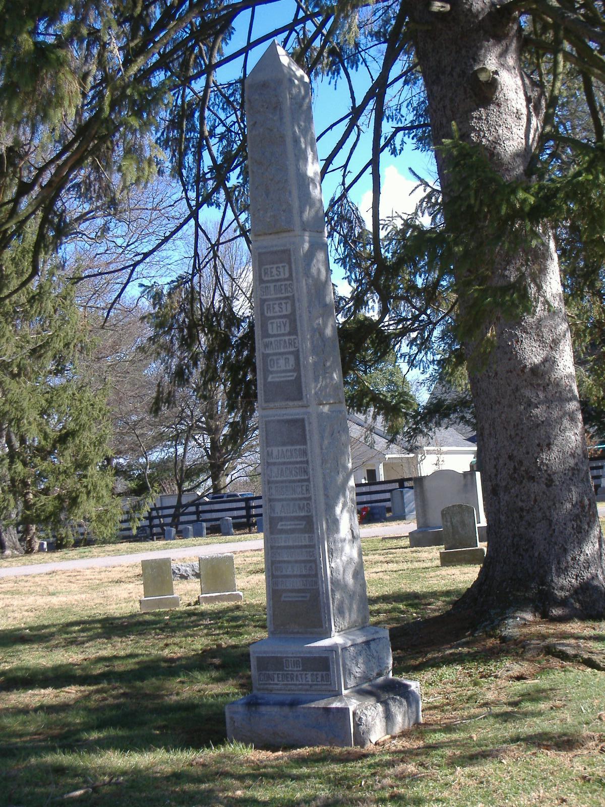
37°53′51″N 84°42′20″W / 37.8975°N 84.705556°WTroy 32 Ezra Hammon House August 22, 1983 Off Kentucky Route 33
37°56′18″N 84°42′02″W / 37.938333°N 84.700556°WKeene 33 A.T. Harris House February 10, 1989 Big Sink Pike
38°06′22″N 84°40′19″W / 38.106111°N 84.671944°WVersailles 34 Hogan Quarters August 22, 1983 Off Kentucky Route 33
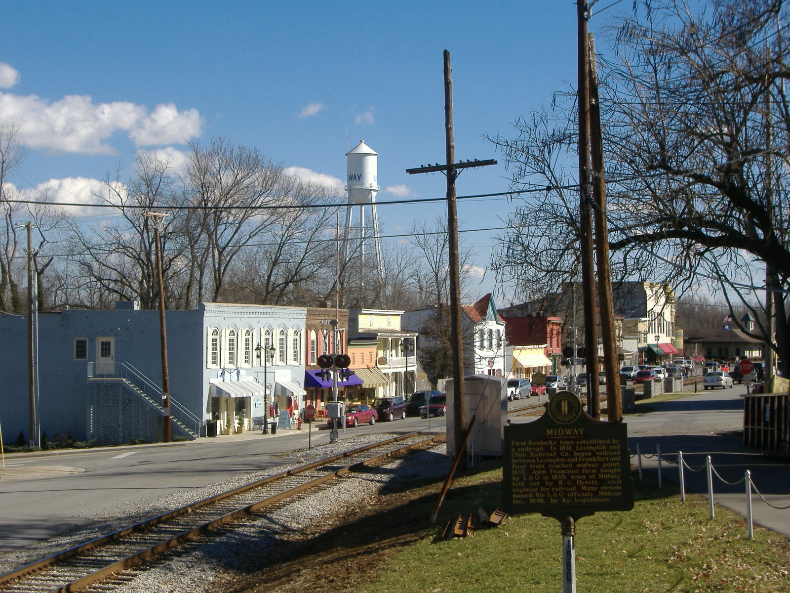
38°01′18″N 84°43′18″W / 38.021667°N 84.721667°WVersailles 35 Humphries Estate Quarters June 23, 1983 Kentucky Route 1967
38°00′07″N 84°40′06″W / 38.001944°N 84.668333°WVersailles 36 Dr. William Jennings House January 12, 1983 South of Pinckard on Kentucky Route 169
37°58′24″N 84°40′49″W / 37.973333°N 84.680278°WPinckard 37 Capt. Jack Jouett House June 13, 1972 5 miles southwest of Versailles off Kentucky Route 1964
37°58′59″N 84°46′31″W / 37.983056°N 84.775278°WVersailles 38 Labrot & Graham Distillery November 7, 1995 7855 McCracken Pike
38°6′46″N 84°48′43″W / 38.11278°N 84.81194°WFrankfort 39 Leavy Tobacco Barn January 27, 1994 Eastern side of Georgetown Rd., 0.8 miles north of the Midway exit from Interstate 64
38°10′04″N 84°39′29″W / 38.167778°N 84.658056°WMidway 40 Thomas Lyne House November 28, 1980 South of Versailles on Smith Lane
37°57′28″N 84°41′06″W / 37.957778°N 84.685°WVersailles 41 Margaret Hall August 3, 1987 117 Elm St.
38°03′26″N 84°43′55″W / 38.057222°N 84.731944°WVersailles 42 Martyrs Monument in Midway 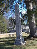
July 17, 1997 City Cemetery, southwest of the junction of the L&N railroad tracks and U.S. Route 62
38°08′53″N 84°41′40″W / 38.148056°N 84.694444°WMidway 43 McCrackin Distillery and Mill June 23, 1983 Kentucky Route 1659
38°05′31″N 84°47′17″W / 38.091944°N 84.788056°WTyrone 44 Cyrus McCrackin House and Quarters August 22, 1983 Off Steele Rd.
38°06′22″N 84°46′52″W / 38.106111°N 84.781111°WTyrone 45 Midway Historic District 
November 17, 1978 U.S. Route 62
38°08′48″N 84°41′14″W / 38.146667°N 84.687222°WMidway 46 Miller's House at Mortonsville Mill June 23, 1983 Kentucky Route 1965
37°58′19″N 84°45′25″W / 37.971944°N 84.756944°WSalvisa 47 George F. Moore Place June 23, 1983 Off U.S. Route 62
38°06′04″N 84°41′34″W / 38.101111°N 84.692778°WVersailles 48 Morgan Street Historic District May 8, 1980 Morgan St.
38°03′06″N 84°43′37″W / 38.051667°N 84.726944°WVersailles 49 Moss Side January 8, 1979 Southwest of Versailles on McCowans Ferry Pike
38°01′10″N 84°46′14″W / 38.019444°N 84.770556°WVersailles 50 Andrew Muldrow Quarters June 23, 1983 Griers Creek Rd.
38°01′06″N 84°49′11″W / 38.018333°N 84.819722°WTyrone 51 Munday's Landing September 5, 1975 Munday's Landing Rd., south of Versailles on the Kentucky River
37°51′13″N 84°46′16″W / 37.853611°N 84.771111°WVersailles 52 Claiborne W. Nuckols Farmstead January 27, 1994 Northern side of U.S. Route 60, 1½ miles north of its junction with Midway Pike
38°05′59″N 84°44′45″W / 38.099722°N 84.745833°WVersailles 53 Nugent's Crossroad Historic District January 27, 1994 Junction of Midway and Old Frankfort Pikes
38°07′25″N 84°41′57″W / 38.123611°N 84.699167°WMidway 54 Offutt-Cole Tavern November 23, 1977 North of Versailles on U.S. Route 62
38°07′24″N 84°42′00″W / 38.123333°N 84.7°WVersailles 55 Paul Family Complex September 23, 1980 West of Troy on Paul's Mill Rd.
37°54′18″N 84°42′42″W / 37.905°N 84.711667°WTroy 56 Lewis Payne House April 29, 1982 Lansing Lane
38°07′29″N 84°39′56″W / 38.124722°N 84.665556°WMidway 57 Pinkerton Hall November 20, 1974 650 East St.
38°08′46″N 84°40′44″W / 38.146111°N 84.678889°WMidway 58 Pisgah Presbyterian Church 
August 22, 1983 Off U.S. Route 60
38°03′14″N 84°39′17″W / 38.053889°N 84.654722°WVersailles 59 Pisgah Rural Historic District February 10, 1989 Area northeast of Versailles roughly bounded by S. Elkhorn Creek, U.S. Route 60, and Big Sink Rd.
38°05′08″N 84°39′40″W / 38.085556°N 84.661111°WVersailles 60 Pleasant Lawn November 15, 1978 North of Versailles off U.S. Route 62 at Bonita
38°05′10″N 84°42′29″W / 38.086111°N 84.708056°WVersailles 61 Redd Road Rural Historic District February 28, 1991 Area largely south and east of the junction of Redd and Frankfort Roads
38°05′30″N 84°37′34″W / 38.091667°N 84.626111°WLexington 62 Robertson Place June 23, 1983 Clifton and Steele Rds.
38°04′38″N 84°48′30″W / 38.077222°N 84.808333°WTyrone 63 Rose Hill Historic District December 17, 1982 Base Hill Ave.
38°03′06″N 84°44′06″W / 38.051667°N 84.735°WVersailles 64 Scearce House April 9, 1987 McCracken Pike
38°05′35″N 84°46′30″W / 38.093056°N 84.775°WVersailles 65 Shipp House June 30, 1983 Address Restricted Midway 66 South Main Street Historic District July 2, 1987 298-321 S. Main St.
38°02′50″N 84°43′47″W / 38.047222°N 84.729722°WVersailles 67 Stone House at Fisher's Mill June 23, 1983 Off U.S. Route 421
38°10′21″N 84°42′16″W / 38.1725°N 84.704444°WMidway 68 Stone House on Beale's Run June 23, 1983 Off Kentucky Route 1685
38°11′02″N 84°44′32″W / 38.183889°N 84.742222°WMidway 69 Stone House on Clifton Pike June 23, 1983 Kentucky Route 1964
38°04′11″N 84°47′09″W / 38.069722°N 84.785833°WTyrone 70 Stone House on Steele's Grant June 23, 1983 Off Kentucky Route 1964
38°04′18″N 84°48′58″W / 38.071667°N 84.816111°WTyrone 71 Stone House on Tanner's Creek June 23, 1983 Carpenter Pike
37°58′49″N 84°45′29″W / 37.980278°N 84.758056°WSalvisa 72 E.W. Taylor House January 27, 1994 Eastern side of Midway Pike, about ½ mile north of its junction with Old Frankfort Pike
38°07′37″N 84°41′03″W / 38.126944°N 84.684167°WMidway 73 Solomon Thomas House June 23, 1983 Craigs Creek Rd.
37°59′21″N 84°48′06″W / 37.989167°N 84.801667°WSalvisa 74 W.B. Spring House June 23, 1983 Off U.S. Route 62
38°06′43″N 84°41′40″W / 38.111944°N 84.694444°WVersailles 75 Wallace Station Historic District January 27, 1994 Wallace Station, Old Frankfort Pike
38°07′16″N 84°41′39″W / 38.121111°N 84.694167°WMidway 76 Samuel Wallace House January 27, 1994 Northern side of Old Frankfort Pike, east of Wallace
38°07′10″N 84°41′16″W / 38.119444°N 84.687778°WMidway 77 Wallace-Alford Farmstead January 27, 1994 S.S. Weisenberger (Craig's) Mill Rd. east of Lansing Ln.
38°07′42″N 84°39′21″W / 38.128333°N 84.655833°WMidway 78 Weisenberger Mills and Related Buildings August 16, 1984 Off U.S. Route 421
38°07′34″N 84°38′13″W / 38.126111°N 84.636944°WMidway 79 Welcome Hall October 10, 1975 4 miles west of Versailles off Clifton Rd.
38°04′26″N 84°47′47″W / 38.073889°N 84.796389°WVersailles 80 Benjamin Wilson House June 23, 1983 Off U.S. Route 62
38°06′43″N 84°41′41″W / 38.111944°N 84.694722°WVersailles 81 Wyndehurst November 15, 1978 5 miles (8 km) southwest of Versailles off Kentucky Route 1964
37°59′39″N 84°46′39″W / 37.994167°N 84.7775°WVersailles See also
- List of National Historic Landmarks in Kentucky
- National Register of Historic Places listings in Kentucky
References
- ^ The latitude and longitude information provided in this table was derived originally from the National Register Information System, which has been found to be fairly accurate for about 99% of listings. For about 1% of NRIS original coordinates, experience has shown that one or both coordinates are typos or otherwise extremely far off; some corrections may have been made. A more subtle problem causes many locations to be off by up to 150 yards, depending on location in the country: most NRIS coordinates were derived from tracing out latitude and longitudes off of USGS topographical quadrant maps created under North American Datum of 1927, which differs from the current, highly accurate GPS system used by Google maps. Chicago is about right, but NRIS longitudes in Washington are higher by about 4.5 seconds, and are lower by about 2.0 seconds in Maine. Latitudes differ by about 1.0 second in Florida. Some locations in this table may have been corrected to current GPS standards.
- ^ "National Register of Historic Places: Weekly List Actions". National Park Service, United States Department of the Interior. Retrieved on November 10, 2011.
- ^ Numbers represent an ordering by significant words. Various colorings, defined here, differentiate National Historic Landmark sites and National Register of Historic Places Districts from other NRHP buildings, structures, sites or objects.
U.S. National Register of Historic Places Topics Lists by states Alabama • Alaska • Arizona • Arkansas • California • Colorado • Connecticut • Delaware • Florida • Georgia • Hawaii • Idaho • Illinois • Indiana • Iowa • Kansas • Kentucky • Louisiana • Maine • Maryland • Massachusetts • Michigan • Minnesota • Mississippi • Missouri • Montana • Nebraska • Nevada • New Hampshire • New Jersey • New Mexico • New York • North Carolina • North Dakota • Ohio • Oklahoma • Oregon • Pennsylvania • Rhode Island • South Carolina • South Dakota • Tennessee • Texas • Utah • Vermont • Virginia • Washington • West Virginia • Wisconsin • WyomingLists by territories Lists by associated states Other  Category:National Register of Historic Places •
  Portal:National Register of Historic Places
Municipalities and communities of Woodford County, Kentucky County seat: Versailles Cities 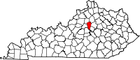
Unincorporated
communitiesPinckard | Spring Station
Categories:- National Register of Historic Places in Kentucky by county
- Woodford County, Kentucky
-


Wikimedia Foundation. 2010.