- National Register of Historic Places listings in Harrison County, Kentucky
-
 Location of Harrison County in Kentucky
This is a list of the National Register of Historic Places listings in Harrison County, Kentucky. It is intended to be a complete list of the properties and districts on the National Register of Historic Places in Harrison County, Kentucky, United States. The locations of National Register properties and districts for which the latitude and longitude coordinates are included below, may be seen in a Google map.[1]
There are approximately 25 properties and districts listed on the National Register in the county.
-
- This National Park Service list is complete through NPS recent listings posted November 10, 2011.[2]
Listings county-wide
[3] Landmark name Image Date listed Location City or town Summary 1 Archeological Site No. 15HR4 February 20, 1986 Address Restricted Lair 2 Church of the Advent, Episcopal December 22, 1978 122 N. Walnut St.
38°23′29″N 84°17′58″W / 38.391389°N 84.299444°WCynthiana 3 Coleman-Desha Plantation February 26, 1993 U.S. Route 62 E., Oddville Pike, 1 mile northeast of Cynthiana
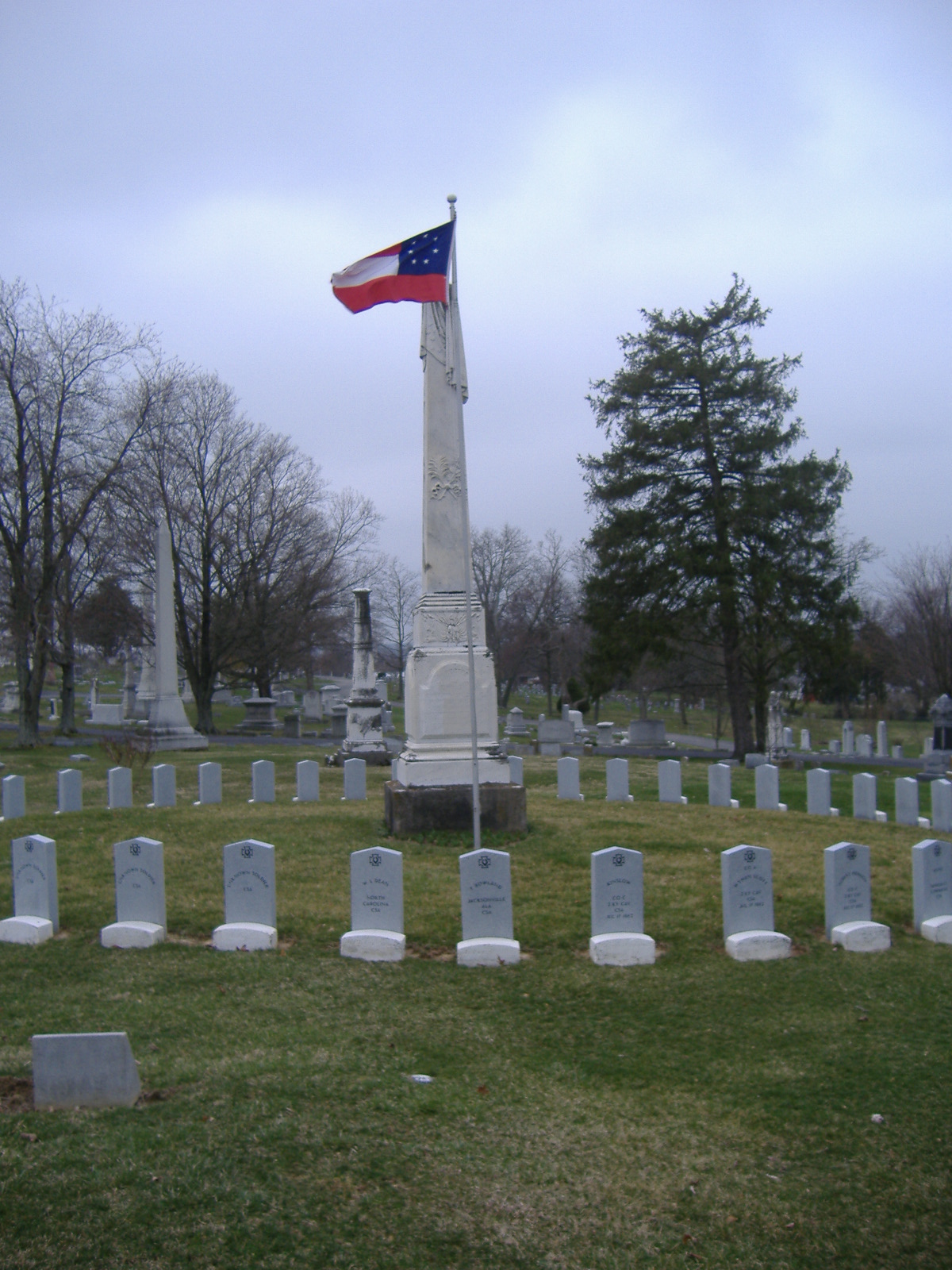
38°24′00″N 84°16′20″W / 38.4°N 84.272222°WCynthiana 4 Confederate Monument in Cynthiana 
July 17, 1997 Battlegrove Cemetery, 0.75 miles east of the junction of S. Elmarch Ave. and Pike St.
38°23′41″N 84°16′51″W / 38.394722°N 84.280833°WCynthiana 5 Cynthiana Commercial District October 19, 1982 Pike St. from Church to Main Sts., and Main St. from Bridge to Pleasant Sts.
38°23′29″N 84°24′40″W / 38.391389°N 84.411111°WCynthiana 6 Joel Fraizer House June 23, 1983 Off KY 982
38°25′06″N 84°16′20″W / 38.418333°N 84.272222°WCynthiana 7 Handy Farm November 25, 2005 U.S. Route 62
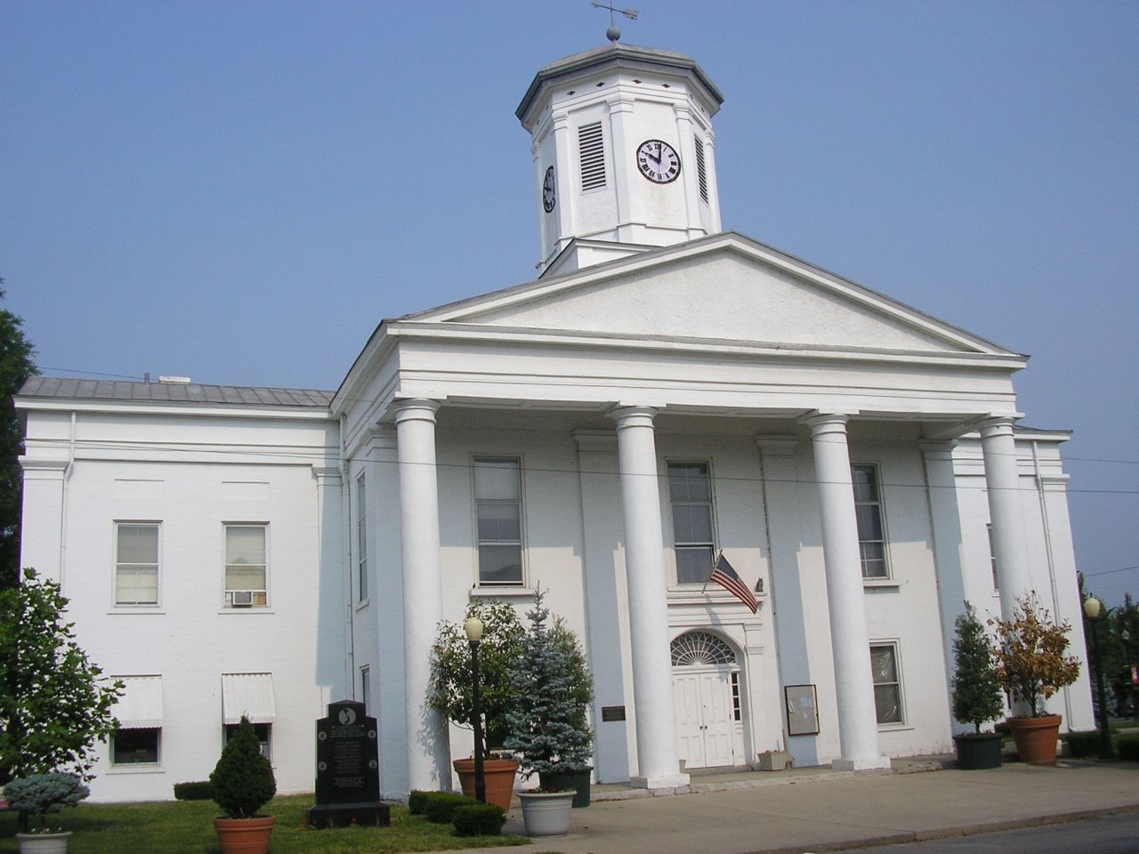
38°23′40″N 84°17′07″W / 38.394444°N 84.285278°WCynthiana 8 Harrison County Courthouse 
December 6, 1974 100 Main St.
38°23′21″N 84°17′52″W / 38.389167°N 84.297778°WCynthiana 9 Haviland House June 23, 1983 Off U.S. Route 62
38°25′28″N 84°15′54″W / 38.424444°N 84.265°WCynthiana 10 John Hinkson House June 23, 1983 Off U.S. Route 27
38°20′29″N 84°18′40″W / 38.341389°N 84.311111°WShawhan 11 Kimbrough-Hehr House April 20, 1979 U.S. Route 62
38°19′39″N 84°21′48″W / 38.3275°N 84.363333°WBroadwell 12 William T. Lafferty House April 10, 1980 548 E. Pike St.
38°23′15″N 84°16′53″W / 38.3875°N 84.281389°WCynthiana 13 John Lair House June 23, 1983 Old Lair Rd.
38°20′24″N 84°17′30″W / 38.34°N 84.291667°WShawhan 14 John McKee House June 23, 1983 Cook Rd.
38°20′51″N 84°16′04″W / 38.3475°N 84.267778°WShawhan 15 Samuel McMillan House June 23, 1983 Off U.S. Route 62
38°20′13″N 84°21′39″W / 38.336944°N 84.360833°WShawhan 16 Monticello December 31, 1974 Monticello Heights
38°22′59″N 84°17′37″W / 38.383056°N 84.293611°WCynthiana 17 Poplar Hill November 7, 1976 East of Cynthiana on KY 32
38°22′59″N 84°16′32″W / 38.383056°N 84.275556°WCynthiana 18 Wesley Roberts House November 10, 1982 113-115 N. Main St.
38°23′28″N 84°17′51″W / 38.391111°N 84.2975°WCynthiana 19 Second Battle of Cynthiana Battlefield 
September 6, 2002 1 mile north of Cynthiana, east of KY 36
38°24′28″N 84°18′39″W / 38.407778°N 84.310833°WCynthiana 20 Joseph Shawhan House June 23, 1983 Off U.S. Route 27
38°18′55″N 84°18′43″W / 38.315278°N 84.311944°WShawhan 21 Smith House June 23, 1983 Off Lair Rd.
38°21′19″N 84°16′47″W / 38.355278°N 84.279722°WShawhan 22 Spur Gasoline Station April 27, 1987 201 E. Bridge St.
38°23′15″N 84°17′46″W / 38.3875°N 84.296111°WCynthiana 23 Stone House of Indian Creek June 23, 1983 Off U.S. Route 62
38°25′06″N 84°16′20″W / 38.418333°N 84.272222°WCynthiana 24 Stoney Castle December 12, 1978 West of Berry on Lafferty Pike
38°31′03″N 84°24′09″W / 38.5175°N 84.4025°WBerry 25 John Williams House June 23, 1983 Off KY 32/KY 36
38°22′11″N 84°15′15″W / 38.369722°N 84.254167°WShawhan See also
- List of National Historic Landmarks in Kentucky
- National Register of Historic Places listings in Kentucky
References
- ^ The latitude and longitude information provided in this table was derived originally from the National Register Information System, which has been found to be fairly accurate for about 99% of listings. For about 1% of NRIS original coordinates, experience has shown that one or both coordinates are typos or otherwise extremely far off; some corrections may have been made. A more subtle problem causes many locations to be off by up to 150 yards, depending on location in the country: most NRIS coordinates were derived from tracing out latitude and longitudes off of USGS topographical quadrant maps created under the North American Datum of 1927, which differs from the current, highly accurate WGS84 GPS system used by Google maps. Chicago is about right, but NRIS longitudes in Washington are higher by about 4.5 seconds, and are lower by about 2.0 seconds in Maine. Latitudes differ by about 1.0 second in Florida. Some locations in this table may have been corrected to current GPS standards.
- ^ "National Register of Historic Places: Weekly List Actions". National Park Service, United States Department of the Interior. Retrieved on November 10, 2011.
- ^ Numbers represent an ordering by significant words. Various colorings, defined here, differentiate National Historic Landmark sites and National Register of Historic Places Districts from other NRHP buildings, structures, sites or objects.
U.S. National Register of Historic Places Topics Lists by states Alabama • Alaska • Arizona • Arkansas • California • Colorado • Connecticut • Delaware • Florida • Georgia • Hawaii • Idaho • Illinois • Indiana • Iowa • Kansas • Kentucky • Louisiana • Maine • Maryland • Massachusetts • Michigan • Minnesota • Mississippi • Missouri • Montana • Nebraska • Nevada • New Hampshire • New Jersey • New Mexico • New York • North Carolina • North Dakota • Ohio • Oklahoma • Oregon • Pennsylvania • Rhode Island • South Carolina • South Dakota • Tennessee • Texas • Utah • Vermont • Virginia • Washington • West Virginia • Wisconsin • WyomingLists by territories Lists by associated states Other Municipalities and communities of Harrison County, Kentucky Cities 
Community Categories:- National Register of Historic Places in Kentucky by county
- Harrison County, Kentucky
-


Wikimedia Foundation. 2010.