- National Register of Historic Places listings in Hart County, Kentucky
-
 Location of Hart County in Kentucky
This is a list of the National Register of Historic Places listings in Hart County, Kentucky. It is intended to be a complete list of the properties and districts on the National Register of Historic Places in Hart County, Kentucky, United States. The locations of National Register properties and districts for which the latitude and longitude coordinates are included below, may be seen in a Google map.[1]
There are approximately 18 properties and districts listed on the National Register in the county.
-
- This National Park Service list is complete through NPS recent listings posted November 10, 2011.[2]
Listings county-wide
[3] Landmark name Image Date listed Location City or town Summary 1 Dr. Lewis Barrett House July 24, 1980 2nd and Caldwell Sts.
37°16′20″N 85°53′21″W / 37.272222°N 85.889167°WMunfordville 2 Battle of Munfordville Site October 15, 1999 Roughly bounded by Green River, U.S. Route 31, Rowletts, and the L&N railroad tracks
37°15′31″N 85°53′28″W / 37.258611°N 85.891111°WMunfordville 3 Chapline Building July 24, 1980 Main St.
37°16′17″N 85°56′06″W / 37.271389°N 85.935°WMunfordville 4 Alvey Cox House July 24, 1980 1st and Washington Sts.
37°16′12″N 85°54′03″W / 37.27°N 85.900833°WMunfordville 5 Gardner House August 4, 2004 Farm lane on the northern side of W. Walker Rd.
37°14′17″N 85°59′44″W / 37.238056°N 85.995556°WNorthtown 6 Hart County Courthouse 
July 24, 1980 Town Sq.
37°16′19″N 85°53′25″W / 37.271944°N 85.890278°WMunfordville 7 Hart County Deposit Bank and Trust Company Building July 24, 1980 Main St.
37°16′21″N 85°53′30″W / 37.2725°N 85.891667°WMunfordville 8 Horse Cave Historic District 
August 2, 2001 KY 218, roughly between U.S. Route 31W and Edwards Ave.,
37°10′44″N 85°54′22″W / 37.178889°N 85.906111°WHorse Cave 9 Munford Inn March 19, 1984 109 Washington St.
37°16′14″N 85°54′05″W / 37.270556°N 85.901389°WMunfordville 10 Munfordville Baptist Church July 24, 1980 313 S. 5th St.
37°16′17″N 85°53′41″W / 37.271389°N 85.894722°WMunfordville 11 Munfordville Presbyterian Church and Green River Lodge No.88 July 24, 1980 3rd and Washington Sts.
37°16′17″N 85°53′32″W / 37.271389°N 85.892222°WMunfordville 12 Munfordville School March 19, 1984 3rd and Washington Sts.
37°16′16″N 85°53′32″W / 37.271111°N 85.892222°WMunfordville 13 Pearce-Wheeler Farm November 25, 2005 640 Sims Cemetery Rd.
37°18′46″N 85°43′02″W / 37.312778°N 85.717222°WCanmer 14 Salts Cave Archeological Site May 15, 1979 Address Restricted Mundfordville 15 Colonel Robert A. Smith Monument 
July 17, 1997 Along CSX railroad tracks, 0.25 miles west of Woodsonville
37°15′27″N 85°53′46″W / 37.2575°N 85.896111°WMunfordviile 16 F.A. Smith House July 24, 1980 204 N. Washington St.
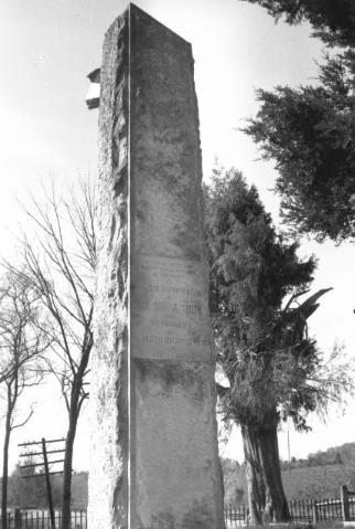
37°16′14″N 85°53′30″W / 37.270556°N 85.891667°WMunfordville 17 Unknown Confederate Soldier Monument in Horse Cave 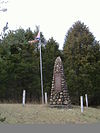
July 17, 1997 Old Dixie Highway, 1 mile south of its junction with Interstate 65
37°11′37″N 85°55′37″W / 37.193611°N 85.926944°WHorse Cave 18 Gen. George T. Wood House July 24, 1980 2nd and Caldwell Sts.
37°16′18″N 88°08′45″W / 37.271667°N 88.145833°WMunfordville See also
- List of National Historic Landmarks in Kentucky
- National Register of Historic Places listings in Kentucky
References
- ^ The latitude and longitude information provided in this table was derived originally from the National Register Information System, which has been found to be fairly accurate for about 99% of listings. For about 1% of NRIS original coordinates, experience has shown that one or both coordinates are typos or otherwise extremely far off; some corrections may have been made. A more subtle problem causes many locations to be off by up to 150 yards, depending on location in the country: most NRIS coordinates were derived from tracing out latitude and longitudes off of USGS topographical quadrant maps created under the North American Datum of 1927, which differs from the current, highly accurate WGS84 GPS system used by Google maps. Chicago is about right, but NRIS longitudes in Washington are higher by about 4.5 seconds, and are lower by about 2.0 seconds in Maine. Latitudes differ by about 1.0 second in Florida. Some locations in this table may have been corrected to current GPS standards.
- ^ "National Register of Historic Places: Weekly List Actions". National Park Service, United States Department of the Interior. Retrieved on November 10, 2011.
- ^ Numbers represent an ordering by significant words. Various colorings, defined here, differentiate National Historic Landmark sites and National Register of Historic Places Districts from other NRHP buildings, structures, sites or objects.
U.S. National Register of Historic Places Topics Lists by states Alabama • Alaska • Arizona • Arkansas • California • Colorado • Connecticut • Delaware • Florida • Georgia • Hawaii • Idaho • Illinois • Indiana • Iowa • Kansas • Kentucky • Louisiana • Maine • Maryland • Massachusetts • Michigan • Minnesota • Mississippi • Missouri • Montana • Nebraska • Nevada • New Hampshire • New Jersey • New Mexico • New York • North Carolina • North Dakota • Ohio • Oklahoma • Oregon • Pennsylvania • Rhode Island • South Carolina • South Dakota • Tennessee • Texas • Utah • Vermont • Virginia • Washington • West Virginia • Wisconsin • WyomingLists by territories Lists by associated states Other Municipalities and communities of Hart County, Kentucky Cities 
Communities Categories:- National Register of Historic Places in Kentucky by county
- Hart County, Kentucky
-


Wikimedia Foundation. 2010.