- National Register of Historic Places listings in Lincoln County, Kentucky
-
 Location of Lincoln County in Kentucky
This is a list of the National Register of Historic Places listings in Lincoln County, Kentucky.
This is intended to be a complete list of the properties and districts on the National Register of Historic Places in Lincoln County, Kentucky, United States. The locations of National Register properties and districts for which the latitude and longitude coordinates are included below, may be seen in a Google map.[1]
There are 22 properties and districts listed on the National Register in the county.
-
- This National Park Service list is complete through NPS recent listings posted November 10, 2011.[2]
Current listings
[3] Landmark name Image Date listed Location City or town Summary 1 James W. Alcorn House April 22, 1980 409 Danville Ave.
37°31′58″N 84°40′09″W / 37.532778°N 84.669167°WStanford 2 Arcadia May 4, 1976 South of Shelby City on U.S. Route 127
37°33′37″N 84°47′21″W / 37.560278°N 84.789167°WShelby City 3 Baughman's Mill and Stanford Railroad Depot 
March 29, 1978 Depot and Mill Sts.
37°31′49″N 84°39′50″W / 37.530278°N 84.663889°WStanford 4 John Baughman House December 22, 1978 South of Stanford on Kentucky Route 1247
37°30′15″N 84°38′44″W / 37.504167°N 84.645556°WStanford 5 Samuel and Mary Logan Briggs House August 28, 1975 315 W. Main St.
37°31′42″N 84°39′54″W / 37.528333°N 84.665°WStanford 6 Confederate Monument at Crab Orchard 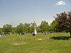
July 17, 1997 Crab Orchard Cemetery, 0.5 miles east of the junction of Kentucky Routes 39 and 643
37°27′52″N 84°30′10″W / 37.464444°N 84.502778°WCrab Orchard 7 Helm-Engleman House January 27, 1983 North of Hubble on Engleman Lane
37°36′55″N 84°39′46″W / 37.615278°N 84.662778°WHubble 8 Hoffman House June 23, 1983 U.S. Route 27
37°34′47″N 84°36′25″W / 37.579722°N 84.606944°WLancaster 9 Nathan Huston House June 23, 1983 Kentucky Route 78
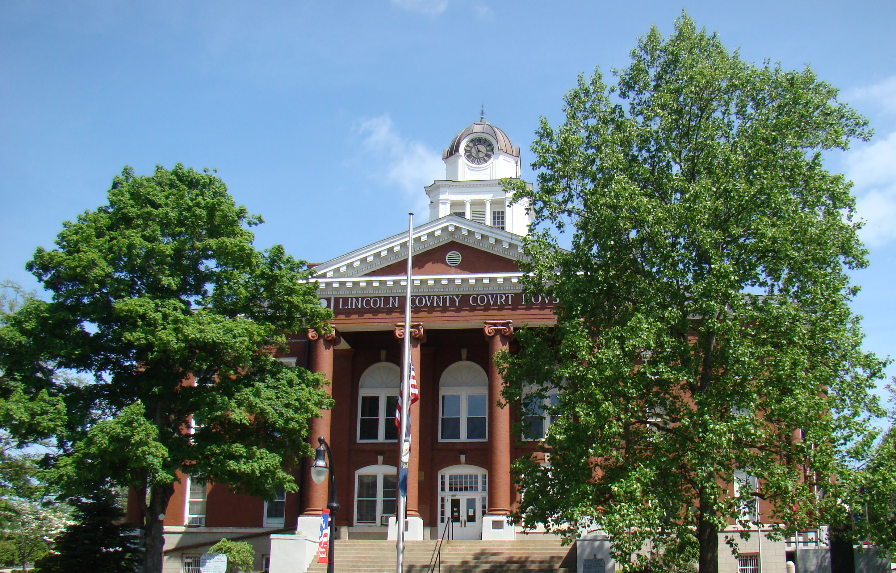
37°28′22″N 84°49′23″W / 37.472778°N 84.823056°WHustonville 10 Lincoln County Courthouse 
April 22, 1976 Main and Lancaster Sts.
37°31′47″N 84°39′41″W / 37.529722°N 84.661389°WStanford 11 John Logan House June 11, 1975 East of Stanford at the junction of U.S. Route 150 and Goshen Rd. (Kentucky Route 642)
37°31′50″N 84°38′34″W / 37.530556°N 84.642778°WStanford 12 McCormack Church March 16, 1976 4 miles west of Stanford on Kentucky Route 1194
37°31′38″N 84°44′37″W / 37.527222°N 84.743611°WStanford 13 Abraham Miller House March 6, 2001 3475 Kentucky Route 300
37°33′34″N 84°44′27″W / 37.559444°N 84.740833°WStanford 14 Dr. Thomas Montgomery House November 17, 1978 Somerset St.
37°31′17″N 84°39′45″W / 37.521389°N 84.6625°WStanford 15 Adam Pence House December 22, 1978 South of Stanford on Kentucky Route 1247
37°28′06″N 84°38′01″W / 37.468333°N 84.633611°WStanford 16 Richland Farm August 4, 2004 5355 Kentucky Route 1194
37°31′07″N 84°47′01″W / 37.518611°N 84.783611°WStanford 17 Stanford Commercial District November 17, 1986 Main St. from Somerset St. to 3rd St.
37°31′44″N 84°39′47″W / 37.528889°N 84.663056°WStanford 18 Swope-Dudderar House and Mill Site April 16, 1979 East of Stanford on Goshen Rd.
37°33′24″N 84°36′03″W / 37.556667°N 84.600833°WStanford 19 Traveler's Rest May 3, 1976 South of Shelby City off Kentucky Route 300
37°33′51″N 84°47′02″W / 37.564167°N 84.783889°WShelby City 20 Walnut Meadows December 22, 1978 Southeast of Stanford on U.S. Route 150
37°29′26″N 84°34′05″W / 37.490556°N 84.568056°WStanford 21 William Whitley House State Shrine 
April 11, 1973 2 miles west of Crab Orchard off U.S. Route 150
37°28′05″N 84°33′00″W / 37.468056°N 84.55°WCrab Orchard 22 Horace Withers House December 30, 1987 Kentucky Route 590 (Hubble Rd.)
37°32′36″N 84°39′08″W / 37.543333°N 84.652222°WStanford See also
- List of National Historic Landmarks in Kentucky
- National Register of Historic Places listings in Kentucky
References
- ^ The latitude and longitude information provided in this table was derived originally from the National Register Information System, which has been found to be fairly accurate for about 99% of listings. For about 1% of NRIS original coordinates, experience has shown that one or both coordinates are typos or otherwise extremely far off; some corrections may have been made. A more subtle problem causes many locations to be off by up to 150 yards, depending on location in the country: most NRIS coordinates were derived from tracing out latitude and longitudes off of USGS topographical quadrant maps created under North American Datum of 1927, which differs from the current, highly accurate GPS system used by Google maps. Chicago is about right, but NRIS longitudes in Washington are higher by about 4.5 seconds, and are lower by about 2.0 seconds in Maine. Latitudes differ by about 1.0 second in Florida. Some locations in this table may have been corrected to current GPS standards.
- ^ "National Register of Historic Places: Weekly List Actions". National Park Service, United States Department of the Interior. Retrieved on November 10, 2011.
- ^ Numbers represent an ordering by significant words. Various colorings, defined here, differentiate National Historic Landmark sites and National Register of Historic Places Districts from other NRHP buildings, structures, sites or objects.
U.S. National Register of Historic Places Topics Lists by states Alabama • Alaska • Arizona • Arkansas • California • Colorado • Connecticut • Delaware • Florida • Georgia • Hawaii • Idaho • Illinois • Indiana • Iowa • Kansas • Kentucky • Louisiana • Maine • Maryland • Massachusetts • Michigan • Minnesota • Mississippi • Missouri • Montana • Nebraska • Nevada • New Hampshire • New Jersey • New Mexico • New York • North Carolina • North Dakota • Ohio • Oklahoma • Oregon • Pennsylvania • Rhode Island • South Carolina • South Dakota • Tennessee • Texas • Utah • Vermont • Virginia • Washington • West Virginia • Wisconsin • WyomingLists by territories Lists by associated states Other  Category:National Register of Historic Places •
  Portal:National Register of Historic Places
Municipalities and communities of Lincoln County, Kentucky County seat: Stanford Cities  Categories:
- National Register of Historic Places in Kentucky by county
- Lincoln County, Kentucky
-


Wikimedia Foundation. 2010.