- National Register of Historic Places listings in Christian County, Kentucky
-
 Location of Christian County in Kentucky
This is a list of the National Register of Historic Places listings in Christian County, Kentucky. It is intended to be a complete list of the properties and districts on the National Register of Historic Places in Christian County, Kentucky, United States. The locations of National Register properties and districts for which the latitude and longitude coordinates are included below, may be seen in a Google map.[1]
There are approximately 47 properties and districts listed on the National Register in the county.
-
- This National Park Service list is complete through NPS recent listings posted November 10, 2011.[2]
Listings county-wide
[3] Landmark name Image Date listed Location City or town Summary 1 Alumni-Latham-Mooreland Historic District July 22, 1993 Alumni Ave., Latham Ave., and Mooreland Dr.
36°51′15″N 87°29′47″W / 36.854167°N 87.496389°WHopkinsville 2 Beverly School April 30, 1979 Off KY 107
36°45′43″N 87°31′29″W / 36.761944°N 87.524722°WHopkinsville 3 Blue Lantern Farm April 30, 1979 U.S. Route 68
36°52′25″N 87°31′18″W / 36.873611°N 87.521667°WHopkinsville 4 Boatright House April 30, 1979 Off U.S. Route 41
36°50′49″N 87°26′55″W / 36.846944°N 87.448611°WHopkinsville 5 Bradshaw House April 30, 1979 Off KY 107
36°45′44″N 87°31′19″W / 36.762222°N 87.521944°WHopkinsville 6 Campbell House April 30, 1979 Junction of KY 164 and KY 272
36°51′30″N 87°33′49″W / 36.858333°N 87.563611°WHopkinsville 7 Cedar Grove November 17, 1977 East of Oak Grove off KY 115
36°39′15″N 87°22′36″W / 36.654167°N 87.376667°WOak Grove 8 Church Hill Grange Hall August 28, 1975 5.5 miles southwest of Hopkinsville on Cox Mill Rd. (KY 695)
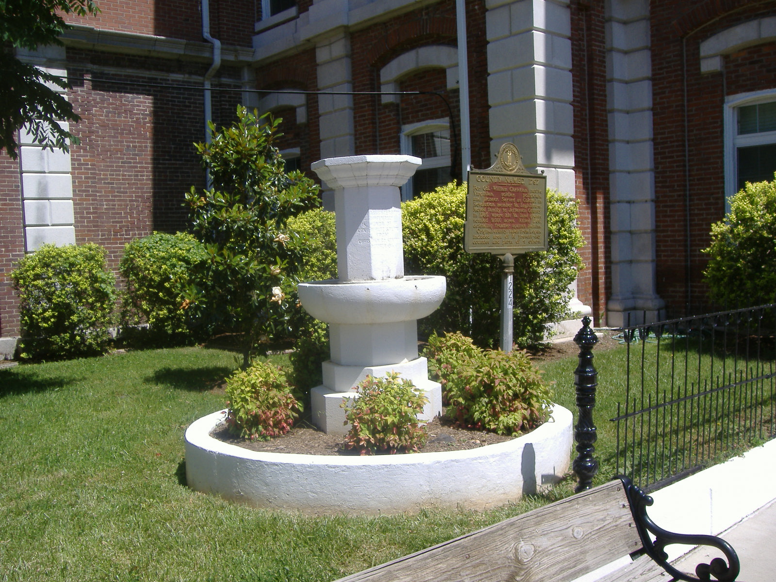
36°47′58″N 87°34′28″W / 36.799444°N 87.574444°WHopkinsville 9 Confederate Memorial Fountain in Hopkinsville 
July 17, 1997 3 blocks north of the junction of U.S. Route 41 and Main St.
36°52′00″N 87°29′17″W / 36.866667°N 87.488056°WHopkinsville 10 Cox House April 30, 1979 South of KY 272
36°49′06″N 87°40′22″W / 36.818333°N 87.672778°WJulien 11 Judge Joseph Crockett House April 3, 1979 317 E. 16th St.
36°51′38″N 87°29′18″W / 36.860556°N 87.488333°WHopkinsville 12 Dalton Brick Company April 30, 1979 2108 S. Main
36°51′23″N 87°29′47″W / 36.85650°N 87.49644°WHopkinsville 13 Monroe Dalton House February 10, 1983 713 E. 7th St.
36°51′49″N 87°28′56″W / 36.863611°N 87.482222°WHopkinsville 14 East 7th Street Historic District September 7, 1983 Roughly bounded by E. 7th St. from Campbell to Belmont Sts.
36°51′49″N 87°28′52″W / 36.863611°N 87.481111°WHopkinsville 15 Elk Grove Farm April 30, 1979 Off U.S. Route 41A
36°45′37″N 87°27′37″W / 36.760278°N 87.460278°WHopkinsville 16 Elliott Place April 30, 1979 North of Lafayette Rd.
36°39′31″N 87°37′43″W / 36.658611°N 87.628611°WLafayette 17 Fairelond September 7, 1983 1303 E. 7th St.
36°51′45″N 87°28′29″W / 36.8625°N 87.474722°WHopkinsville 18 Freeman Chapel C.M.E. Church May 26, 1983 137 S. Virginia St.
36°52′08″N 87°29′08″W / 36.868889°N 87.485556°WHopkinsville 19 Simon French House April 30, 1979 Carter Rd., South of Barkers Mill
36°39′10″N 87°21′32″W / 36.652778°N 87.358889°WHensleytown 20 John C. Gary House April 30, 1979 Gary Lane, South of KY 695
36°48′45″N 87°31′45″W / 36.8125°N 87.529167°WHopkinsville 21 Genoa April 30, 1979 Palmyra Rd.
36°43′09″N 87°31′54″W / 36.719167°N 87.531667°WHowel 22 Glen Burnie April 30, 1979 Bumpus Mill Rd.
36°41′00″N 87°23′30″W / 36.683333°N 87.391667°WHopkinsville 23 Grace Episcopal Church January 28, 1982 220 E. 6th St.
36°51′59″N 87°29′09″W / 36.866389°N 87.485833°WHopkinsville 24 E. H. Higgins House January 3, 1984 1530 E. 7th St.
36°51′55″N 87°28′08″W / 36.865278°N 87.468889°WHopkinsville 25 Hopkinsville Commercial Historic District 
April 30, 1979 Roughly bounded by the L&N railroad line and 10th, 5th, and Bethel Sts.
36°51′49″N 87°49′44″W / 36.863611°N 87.828889°WHopkinsville 26 Hopkinsville L & N Railroad Depot 
August 1, 1975 425 E. 9th St.
36°51′49″N 87°29′07″W / 36.863611°N 87.485278°WHopkinsville 27 Hopkinsville Residential Historic District April 30, 1979 Roughly bounded by 14th, 20th, Main, and Virginia Sts.; also the southwestern corner of Main and 13th Sts.
36°51′38″N 87°29′30″W / 36.86042°N 87.49166°WHopkinsville Second address represents a boundary increase 28 Hopkinsville Warehouse Historic District April 30, 1979 Roughly along Harrison St. and railroad tracks from 2nd to 21st Sts.
36°51′32″N 87°29′11″W / 36.85878°N 87.48636°WHopkinsville 29 Hopper Court April 30, 1979 Hopper Ct.
4°07′43″N 87°49′47″W / 4.128611°N 87.829722°WHopkinsville 30 J. B. Knight House April 30, 1979 1417 E. 7th St.
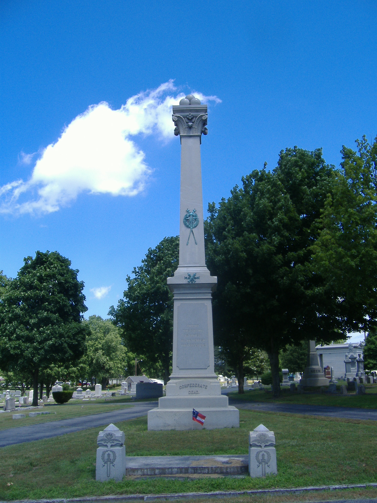
36°51′32″N 87°29′11″W / 36.858889°N 87.486389°WHopkinsville 31 Lafayette Methodist Church April 30, 1979 Off KY 107 Lafayette 32 Latham Confederate Monument 
July 17, 1997 Riverside Cemetery, west of Hopkinsville between U.S. Route 41 and L&N railroad tracks.
36°52′31″N 87°28′53″W / 36.875278°N 87.481389°WHopkinsville 33 Maplewood April 30, 1979 Off Mason Lane
36°44′21″N 87°20′28″W / 36.739167°N 87.341111°WPembroke 34 McClellen House April 30, 1979 KY 508
36°53′13″N 87°20′00″W / 36.886944°N 87.333333°WHoney Grove 35 McRay Site (15CH139) February 3, 1983 Address Restricted Hopkinsville 36 Oakland/Henry House April 30, 1979 KY 164
36°49′04″N 87°36′05″W / 36.817778°N 87.601389°WHopkinsville 37 Pilot Rock Petroglyphs (15CH200) September 8, 1989 Address Restricted Hopkinsville 38 Poston House April 30, 1979 809 Hayes St.
36°52′02″N 87°28′41″W / 36.86709°N 87.47798°WHopkinsville 39 Rich Grove April 30, 1979 Off KY 109, north of Highway 1027
36°46′22″N 87°26′13″W / 36.772778°N 87.436944°WHopkinsville 40 Ritter House April 30, 1979 Off U.S. Route 41A
36°49′41″N 87°28′56″W / 36.828056°N 87.482222°WHopkinsville 41 Smokehouse on Riverside Creek January 8, 1987 Petsch Ln. off KY 272
36°51′51″N 87°34′50″W / 36.864167°N 87.580556°WHopkinsville 42 Dr. Edward S. Stewart House April 30, 1979 U.S. Route 68
36°50′34″N 87°18′10″W / 36.842778°N 87.302778°WFairview 43 E. W. Walker House September 7, 1983 1414 E. 7th St.
36°51′52″N 87°28′18″W / 36.864444°N 87.471667°WHopkinsville 44 Western Lunatic Asylum April 30, 1979 U.S. Route 68
36°51′54″N 87°27′04″W / 36.865°N 87.451111°WHopkinsville 45 Whitepath and Fly Smith Gravesite November 26, 2004 Address restricted
36°51′8″N 87°28′17″W / 36.85222°N 87.47139°W[4]Hopkinsville 46 Woodlawn April 30, 1979 Off U.S. Route 41A
36°46′09″N 87°27′38″W / 36.769167°N 87.460556°WHopkinsville 47 Frank K. Yost House September 7, 1983 1131 E. 7th St.
36°51′44″N 87°28′35″W / 36.862222°N 87.476389°WHopkinsville See also
- List of National Historic Landmarks in Kentucky
- National Register of Historic Places listings in Kentucky
References
- ^ The latitude and longitude information provided in this table was derived originally from the National Register Information System, which has been found to be fairly accurate for about 99% of listings. For about 1% of NRIS original coordinates, experience has shown that one or both coordinates are typos or otherwise extremely far off; some corrections may have been made. A more subtle problem causes many locations to be off by up to 150 yards, depending on location in the country: most NRIS coordinates were derived from tracing out latitude and longitudes off of USGS topographical quadrant maps created under the North American Datum of 1927, which differs from the current, highly accurate WGS84 GPS system used by Google maps. Chicago is about right, but NRIS longitudes in Washington are higher by about 4.5 seconds, and are lower by about 2.0 seconds in Maine. Latitudes differ by about 1.0 second in Florida. Some locations in this table may have been corrected to current GPS standards.
- ^ "National Register of Historic Places: Weekly List Actions". National Park Service, United States Department of the Interior. Retrieved on November 10, 2011.
- ^ Numbers represent an ordering by significant words. Various colorings, defined here, differentiate National Historic Landmark sites and National Register of Historic Places Districts from other NRHP buildings, structures, sites or objects.
- ^ Address given as P.O. Box 350; no physical location is provided by the NRIS
U.S. National Register of Historic Places Topics Lists by states Alabama • Alaska • Arizona • Arkansas • California • Colorado • Connecticut • Delaware • Florida • Georgia • Hawaii • Idaho • Illinois • Indiana • Iowa • Kansas • Kentucky • Louisiana • Maine • Maryland • Massachusetts • Michigan • Minnesota • Mississippi • Missouri • Montana • Nebraska • Nevada • New Hampshire • New Jersey • New Mexico • New York • North Carolina • North Dakota • Ohio • Oklahoma • Oregon • Pennsylvania • Rhode Island • South Carolina • South Dakota • Tennessee • Texas • Utah • Vermont • Virginia • Washington • West Virginia • Wisconsin • WyomingLists by territories Lists by associated states Other Municipalities and communities of Christian County, Kentucky Cities Crofton | Hopkinsville | LaFayette | Oak Grove | Pembroke

CDP Unincorporated
communitiesFairview | Fearsville | Gracey
Categories:- National Register of Historic Places in Kentucky by county
- Christian County, Kentucky
-


Wikimedia Foundation. 2010.