- National Register of Historic Places listings in Todd County, Kentucky
-
 Location of Todd County in Kentucky
This is a list of the National Register of Historic Places listings in Todd County, Kentucky.
This is intended to be a complete list of the properties and districts on the National Register of Historic Places in Todd County, Kentucky, United States. The locations of National Register properties and districts for which the latitude and longitude coordinates are included below, may be seen in a Google map.[1]
There are 15 properties and districts listed on the National Register in the county.
-
- This National Park Service list is complete through NPS recent listings posted November 10, 2011.[2]
Current listings
[3] Landmark name Image Date listed Location City or town Summary 1 Allensville Historic District November 14, 1988 Kentucky Route 102/Main St.
36°42′58″N 87°04′06″W / 36.716111°N 87.068333°WAllensville 2 Bethel Baptist Church November 17, 1977 U.S. Route 68
36°50′37″N 87°17′55″W / 36.843611°N 87.298611°WFairview 3 Jefferson Davis Monument 
May 9, 1973 On Kentucky Route 115 near its junction with U.S. Route 68
36°50′31″N 87°18′02″W / 36.841944°N 87.300556°WFairview 4 Edwards Hall January 11, 1974 Southern side of Goebel Ave.
36°48′14″N 87°09′07″W / 36.803889°N 87.151944°WElkton 5 Elkton Commercial Historic District November 13, 1989 Junction of N., S., E., and W. Main Sts.
36°48′34″N 87°09′15″W / 36.809444°N 87.154167°WElkton 6 Gray's Inn November 26, 2004 88 Graysville Rd.
36°38′46″N 87°11′57″W / 36.646111°N 87.199167°WGuthrie 7 John Gray Springhouse January 8, 1987 U.S. Route 68
36°48′42″N 87°09′32″W / 36.811667°N 87.158889°WElkton 8 Guthrie Historic District November 10, 2011 Roughly bounded by Ewing, Park & Cherry Sts.
36°38′54″N 87°09′59″W / 36.648378°N 87.166392°WGuthrie 9 Hadden Site (15TO1) December 19, 1985 Address Restricted Elkton 10 Idlewild April 10, 1980 Southeast of Trenton on U.S. Route 41
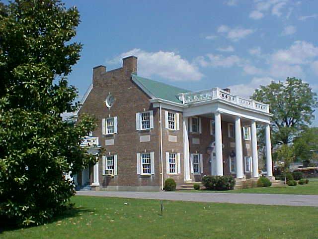
36°41′14″N 87°13′52″W / 36.687222°N 87.231111°WTrenton 11 McReynolds House October 22, 1976 S. Main St.
36°48′25″N 87°09′18″W / 36.806944°N 87.155°WElkton 12 Milliken Memorial Community House 
December 6, 1990 208 W. Main St.
36°48′37″N 87°09′21″W / 36.810278°N 87.155833°WElkton 13 W.L. Reeves House February 2, 1984 Kentucky Route 102
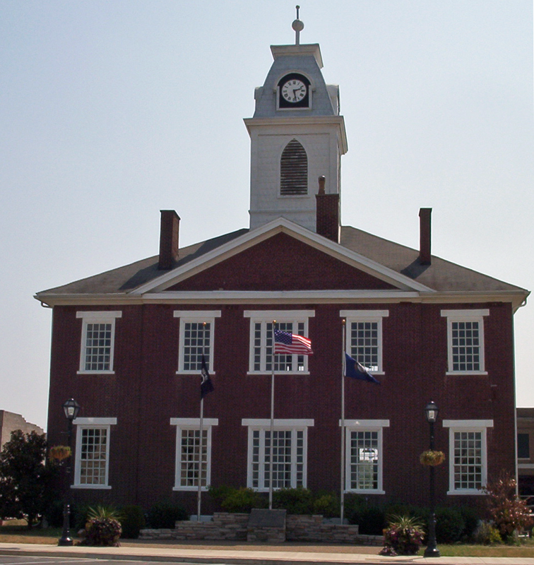
36°48′12″N 87°08′54″W / 36.803333°N 87.148333°WElkton 14 Todd County Courthouse 
August 22, 1975 Public Sq.
36°48′34″N 87°09′15″W / 36.809444°N 87.154167°WElkton 15 Woodstock November 10, 2010 6338 Clarksville Rd.
36°38′31″N 87°18′53″W / 36.641944°N 87.314722°WTrenton vicinity See also
- List of National Historic Landmarks in Kentucky
- National Register of Historic Places listings in Kentucky
References
- ^ The latitude and longitude information provided in this table was derived originally from the National Register Information System, which has been found to be fairly accurate for about 99% of listings. For about 1% of NRIS original coordinates, experience has shown that one or both coordinates are typos or otherwise extremely far off; some corrections may have been made. A more subtle problem causes many locations to be off by up to 150 yards, depending on location in the country: most NRIS coordinates were derived from tracing out latitude and longitudes off of USGS topographical quadrant maps created under the North American Datum of 1927, which differs from the current, highly accurate WGS84 GPS system used by Google maps. Chicago is about right, but NRIS longitudes in Washington are higher by about 4.5 seconds, and are lower by about 2.0 seconds in Maine. Latitudes differ by about 1.0 second in Florida. Some locations in this table may have been corrected to current GPS standards.
- ^ "National Register of Historic Places: Weekly List Actions". National Park Service, United States Department of the Interior. Retrieved on November 10, 2011.
- ^ Numbers represent an ordering by significant words. Various colorings, defined here, differentiate National Historic Landmark sites and National Register of Historic Places Districts from other NRHP buildings, structures, sites or objects.
U.S. National Register of Historic Places Topics Lists by states Alabama • Alaska • Arizona • Arkansas • California • Colorado • Connecticut • Delaware • Florida • Georgia • Hawaii • Idaho • Illinois • Indiana • Iowa • Kansas • Kentucky • Louisiana • Maine • Maryland • Massachusetts • Michigan • Minnesota • Mississippi • Missouri • Montana • Nebraska • Nevada • New Hampshire • New Jersey • New Mexico • New York • North Carolina • North Dakota • Ohio • Oklahoma • Oregon • Pennsylvania • Rhode Island • South Carolina • South Dakota • Tennessee • Texas • Utah • Vermont • Virginia • Washington • West Virginia • Wisconsin • WyomingLists by territories Lists by associated states Other Municipalities and communities of Todd County, Kentucky Cities Allensville | Elkton | Guthrie | Trenton
 Categories:
- National Register of Historic Places in Kentucky by county
- Todd County, Kentucky
-


Wikimedia Foundation. 2010.