- National Register of Historic Places listings in Daviess County, Kentucky
-
 Location of Daviess County in Kentucky
This is a list of the National Register of Historic Places listings in Daviess County, Kentucky. It is intended to be a complete list of the properties and districts on the National Register of Historic Places in Daviess County, Kentucky, United States. The locations of National Register properties and districts for which the latitude and longitude coordinates are included below, may be seen in a Google map.[1]
There are approximately 35 properties and districts listed on the National Register in the county.
-
- This National Park Service list is complete through NPS recent listings posted November 10, 2011.[2]
Listings county-wide
[3] Landmark name Image Date listed Location City or town Summary 1 Archeological Site 15 Da 39 December 22, 1978 Address Restricted Maceo 2 D.D. Bogard House May 22, 1980 303 E. 4th St.
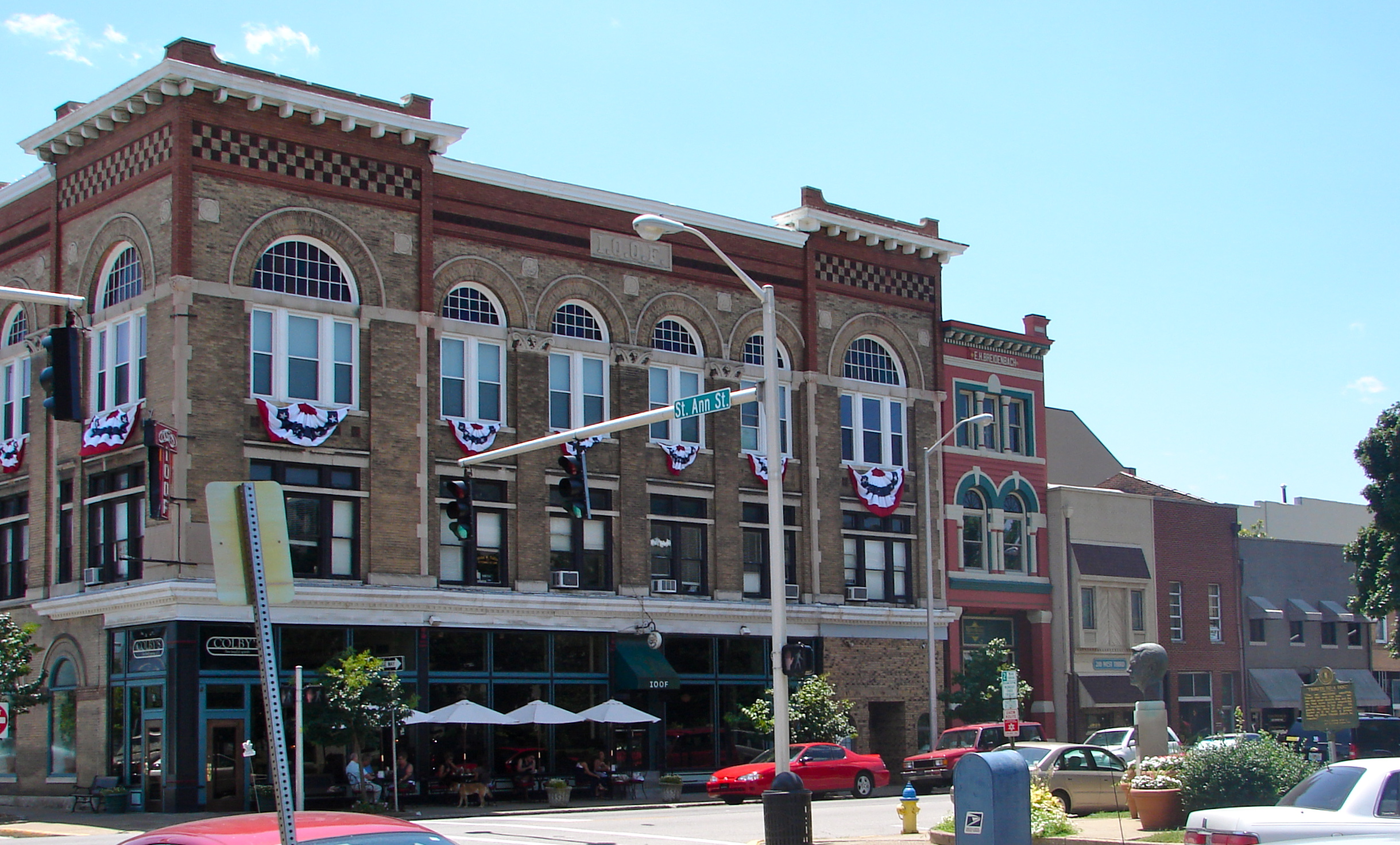
37°46′22″N 87°06′30″W / 37.772778°N 87.108333°WOwensboro 3 Breidenbach Building March 28, 1986 208 W. 3rd St.
37°46′24″N 87°06′45″W / 37.773333°N 87.1125°WOwensboro 4 Callas Sweet Shop March 28, 1986 420 Frederica Ave.
37°46′19″N 87°06′48″W / 37.771944°N 87.113333°WOwensboro 5 Carnegie Free Public Library (DAOB 41) August 6, 1986 901 Frederica Ave.
37°46′05″N 87°06′45″W / 37.768056°N 87.1125°WOwensboro 6 Le Vega Clements House March 28, 1986 1500 N. Highland Ave.
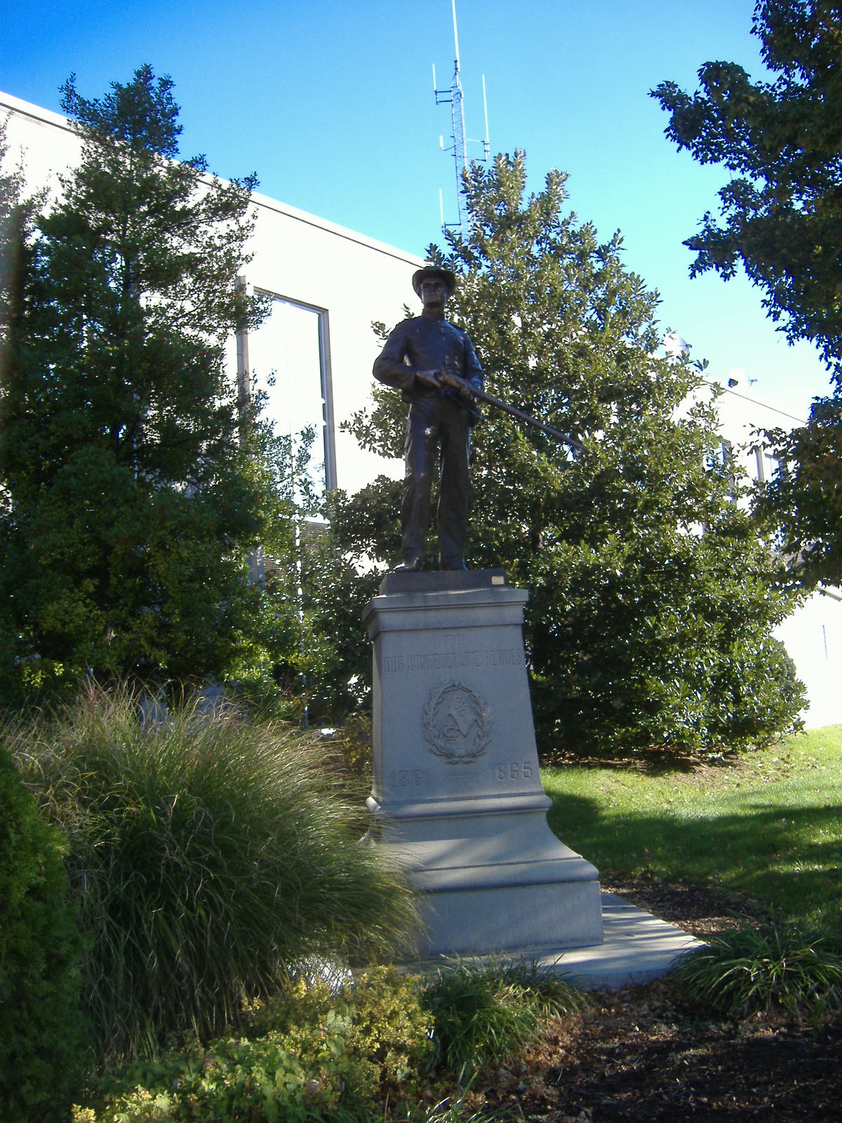
37°46′26″N 87°05′30″W / 37.773889°N 87.091667°WOwensboro 7 Confederate Monument in Owensboro 
July 17, 1997 1 block north of the junction of U.S. Routes 60 and 431
37°46′24″N 87°06′48″W / 37.773333°N 87.113333°WOwensboro 8 Howell J. Davis House August 3, 1990 3301 Veach Rd.
37°44′18″N 87°06′08″W / 37.738333°N 87.102222°WOwensboro 9 Doctors' Row Historic District March 28, 1986 W. 4th St. between Frederica and Saint Ann Sts.
37°46′22″N 87°06′44″W / 37.772778°N 87.112222°WOwensboro 10 Federal Building and US Post Office-Owensboro April 13, 1989 5th and Frederica
37°46′18″N 87°06′46″W / 37.771667°N 87.112778°WOwensboro 11 Gillim House March 28, 1986 517 Frederica St.
37°46′15″N 87°06′46″W / 37.770833°N 87.112778°WOwensboro 12 Felix Grimes House June 18, 1975 1301 Leitchfield Rd.
37°45′54″N 87°05′21″W / 37.765°N 87.089167°WOwensboro 13 Haphazard August 22, 1975 Pleasant Valley Rd.
37°46′56″N 87°04′24″W / 37.782222°N 87.073333°WOwensboro 14 McKay-Thornberry House May 3, 1984 S. Hampton Rd.
37°45′42″N 86°58′00″W / 37.761667°N 86.966667°WOwensboro 15 Medley House February 20, 1980 1220 Frederica St.
37°45′38″N 87°06′28″W / 37.760556°N 87.107778°WOwensboro 16 George and Sons Mischel Building March 28, 1986 412 E. 2nd St.
37°46′29″N 87°06′25″W / 37.774722°N 87.106944°WOwensboro 17 Monarch-Payne House March 28, 1986 1432 E. 4th St.
37°46′25″N 87°05′33″W / 37.773611°N 87.0925°WOwensboro 18 J.Z. Moore Historic District March 28, 1986 Roughly bounded by W. and E. 12th, Daviess, E. and W. 14th, and Saint Ann Sts.
37°45′51″N 87°06′37″W / 37.764167°N 87.110278°WOwensboro 19 Moorman House March 27, 1992 2731 W. 2nd St.
37°46′29″N 87°08′40″W / 37.774722°N 87.144444°WOwensboro 20 Mount St. Joseph Academy January 25, 1979 KY 56
37°41′35″N 87°19′30″W / 37.693056°N 87.325°WSt. Joseph 21 Odd Fellows Building March 28, 1986 200-204 W. 3rd St.
37°46′24″N 87°06′44″W / 37.773333°N 87.112222°WOwensboro 22 Owensboro Armory September 6, 2002 1501 Parrish Ave. Owensboro 23 Owensboro Historic Commercial District 
January 12, 1983 2nd St. between St. Ann and Lewis Sts.
37°46′29″N 87°06′38″W / 37.774722°N 87.110556°WOwensboro 24 Owensboro Historic Downtown Commercial District July 26, 2005 Roughly between Frederica, Clay, 2nd, and 4th Sts.
37°46′27″N 87°06′38″W / 37.774167°N 87.110556°WOwensboro 25 Phillip's Court District March 28, 1986 Roughly bounded by Technical High School, Cruze Dr., W. 18th St., and Frederica Ave.
37°45′37″N 87°06′42″W / 37.760278°N 87.111667°WOwensboro 26 Camden Riley House March 28, 1986 112 E. 4th St.
37°46′24″N 87°06′38″W / 37.773333°N 87.110556°WOwensboro 27 St. Joseph Church November 3, 1983 4th and Clay Sts.
37°46′21″N 87°06′21″W / 37.7725°N 87.105833°WOwensboro 28 Maj. Hampden Smith House September 28, 1976 909 Frederica St.
37°45′59″N 87°06′45″W / 37.766389°N 87.1125°WOwensboro 29 James J. Sweeney House August 11, 1980 121 E. 5th St.
37°46′19″N 87°06′32″W / 37.771944°N 87.108889°WOwensboro 30 Temple Adath Israel March 28, 1986 429 Daviess St.
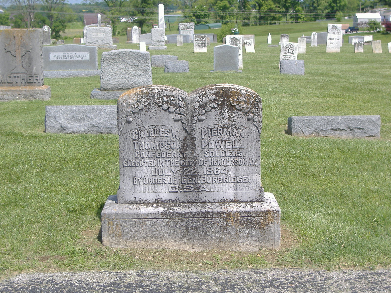
37°46′18″N 87°06′34″W / 37.771667°N 87.109444°WOwensboro 31 Thompson and Powell Martyrs Monument 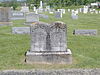
July 17, 1997 Junction of KY 56 and KY 500
37°41′43″N 87°19′30″W / 37.695278°N 87.325°WSt. Joseph 32 Trinity Episcopal Church April 10, 1972 403 W. 5th St.
37°46′21″N 87°06′53″W / 37.7725°N 87.114722°WOwensboro 33 Union Station 
August 1, 1979 1039 Frederica St.
37°45′56″N 87°06′45″W / 37.765556°N 87.1125°WOwensboro 34 Willow Hill June 9, 1982 Jones Rd.
37°47′01″N 87°00′48″W / 37.783611°N 87.013333°WOwensboro 35 Yewell House March 28, 1986 630 Clay St.
37°46′11″N 87°06′22″W / 37.769722°N 87.106111°WOwensboro See also
- List of National Historic Landmarks in Kentucky
- National Register of Historic Places listings in Kentucky
References
- ^ The latitude and longitude information provided in this table was derived originally from the National Register Information System, which has been found to be fairly accurate for about 99% of listings. For about 1% of NRIS original coordinates, experience has shown that one or both coordinates are typos or otherwise extremely far off; some corrections may have been made. A more subtle problem causes many locations to be off by up to 150 yards, depending on location in the country: most NRIS coordinates were derived from tracing out latitude and longitudes off of USGS topographical quadrant maps created under North American Datum of 1927, which differs from the current, highly accurate GPS system used by Google maps. Chicago is about right, but NRIS longitudes in Washington are higher by about 4.5 seconds, and are lower by about 2.0 seconds in Maine. Latitudes differ by about 1.0 second in Florida. Some locations in this table may have been corrected to current GPS standards.
- ^ "National Register of Historic Places: Weekly List Actions". National Park Service, United States Department of the Interior. Retrieved on November 10, 2011.
- ^ Numbers represent an ordering by significant words. Various colorings, defined here, differentiate National Historic Landmark sites and National Register of Historic Places Districts from other NRHP buildings, structures, sites or objects.
U.S. National Register of Historic Places Topics Lists by states Alabama • Alaska • Arizona • Arkansas • California • Colorado • Connecticut • Delaware • Florida • Georgia • Hawaii • Idaho • Illinois • Indiana • Iowa • Kansas • Kentucky • Louisiana • Maine • Maryland • Massachusetts • Michigan • Minnesota • Mississippi • Missouri • Montana • Nebraska • Nevada • New Hampshire • New Jersey • New Mexico • New York • North Carolina • North Dakota • Ohio • Oklahoma • Oregon • Pennsylvania • Rhode Island • South Carolina • South Dakota • Tennessee • Texas • Utah • Vermont • Virginia • Washington • West Virginia • Wisconsin • WyomingLists by territories Lists by associated states Other  Category:National Register of Historic Places •
  Portal:National Register of Historic Places
Municipalities and communities of Daviess County, Kentucky County seat: Owensboro Cities 
CDP Unincorporated
communitiesCurdsville | Friendly Village | Knottsville | Maceo | Philpot | Rome | Sorgho | Stanley | Utica | West Louisville | Yelvington
Categories:- National Register of Historic Places in Kentucky by county
- Daviess County, Kentucky
-


Wikimedia Foundation. 2010.