- National Register of Historic Places listings in Bingham County, Idaho
-
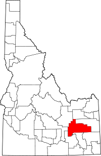 Location of Bingham County in Idaho
This is a list of the National Register of Historic Places listings in Bingham County, Idaho.
This is intended to be a complete list of the properties and districts on the National Register of Historic Places in Bingham County, Idaho, United States. Latitude and longitude coordinates are provided for many National Register properties and districts; these locations may be seen together in a Google map.[1]
There are 17 properties and districts listed on the National Register in the county. More may be added; properties and districts nationwide are added to the Register weekly.[2]
-
- This National Park Service list is complete through NPS recent listings posted November 10, 2011.[3]
Current listings
[4] Landmark name [5] Image Date listed Location City or town Summary 1 Aviator's Cave July 22, 2010 Address restricted[6] Arco vicinity 2 Blackfoot I.O.O.F. Hall May 15, 1979 57 Bridge St.
43°11′22″N 112°20′41″W / 43.189444°N 112.344722°WBlackfoot 3 Blackfoot LDS Tabernacle 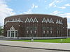
September 19, 1977 120 S. Shilling St.
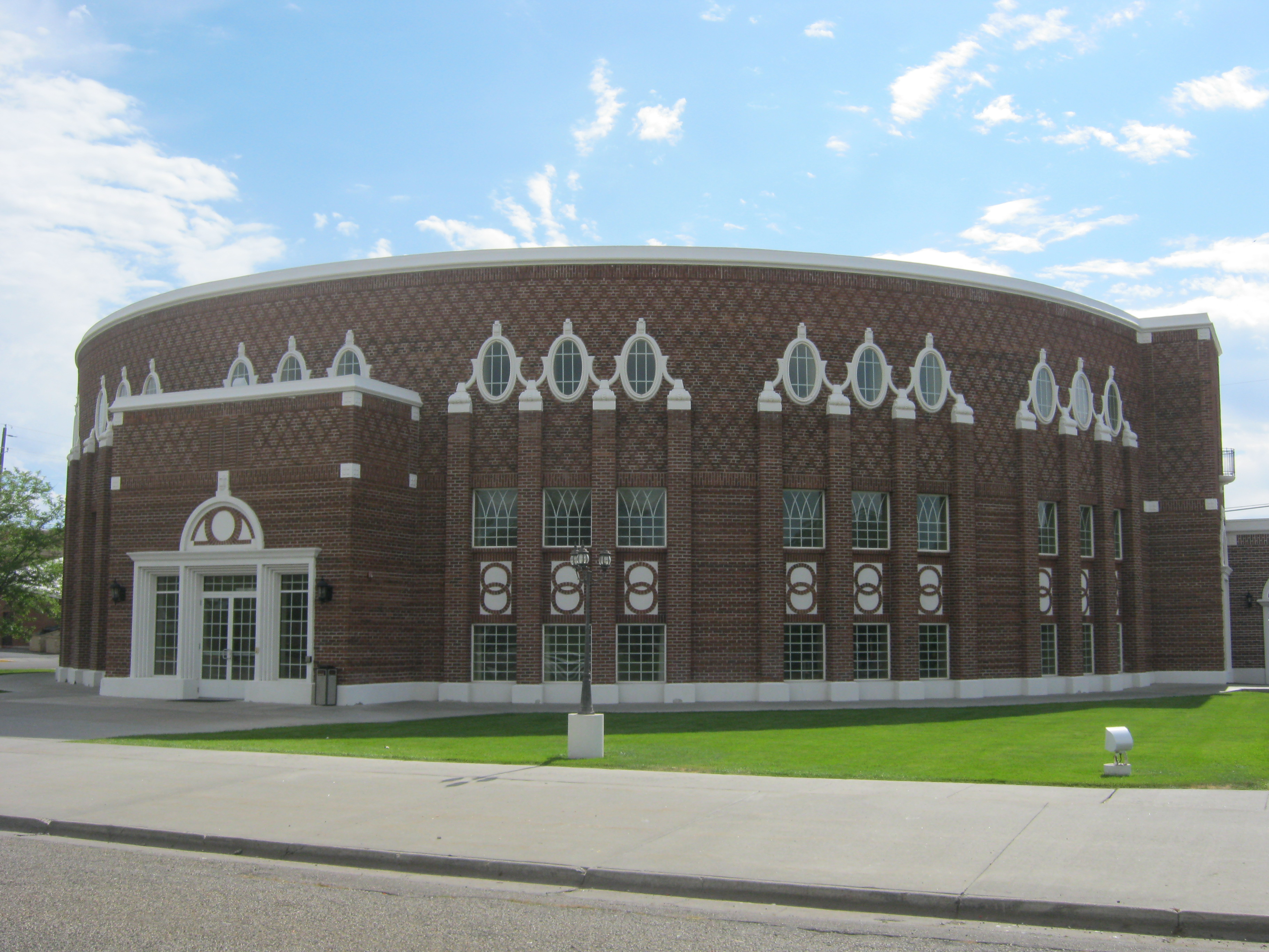
43°11′12″N 112°20′34″W / 43.186667°N 112.342778°WBlackfoot 4 Blackfoot Railway Depot November 20, 1974 130 NW Main St.
43°11′22″N 112°20′35″W / 43.189444°N 112.343056°WBlackfoot Now houses the Idaho Potato Museum 5 Eastern Idaho District Fair Historic District August 10, 2001 97 Park Dr.
43°11′45″N 112°20′23″W / 43.195833°N 112.339722°WBlackfoot 6 Fort Hall Site November 21, 1974 16 miles north of Fort Hall Fort Hall 7 Idaho Republican Building October 16, 1979 167 W. Bridge St.
43°11′24″N 112°20′44″W / 43.19°N 112.345556°WBlackfoot 8 J.W. Jones Building November 17, 1982 104 Main St., NE.
43°11′23″N 112°20′38″W / 43.189722°N 112.343889°WBlackfoot 9 Lincoln Creek Day School April 9, 2010 Rich Lane, eight miles southeast of Idaho State Highway 91 Fort Hall 10 North Shilling Historic District August 29, 1979 N. Shilling Ave.
43°11′19″N 112°20′28″W / 43.188611°N 112.341111°WBlackfoot 11 Nuart Theater October 19, 1978 195 N. Broadway
43°11′27″N 112°20′38″W / 43.190833°N 112.343889°WBlackfoot 12 Ross Fork Episcopal Church January 3, 1983 Mission Rd.
43°11′23″N 112°20′38″W / 43.189722°N 112.343889°WFort Hall 13 Ross Fork Oregon Short Lines Railroad Depot September 7, 1984 Agency Rd.
43°01′47″N 112°25′51″W / 43.029722°N 112.430833°WFort Hall 14 St. Paul's Episcopal Church May 15, 1979 72 N. Shilling Ave.
43°11′17″N 112°20′29″W / 43.188056°N 112.341389°WBlackfoot 15 Shilling Avenue Historic District August 18, 1983 Shilling Ave. between E. Idaho and Bingham Sts. and Bridge and Judicial Sts. to Stout Ave.
43°11′13″N 112°20′32″W / 43.186944°N 112.342222°WBlackfoot 16 Standrod Bank August 30, 1979 59 and 75 Main St., W.
43°11′22″N 112°20′40″W / 43.189444°N 112.344444°WBlackfoot 17 US Post Office-Blackfoot Main March 16, 1989 165 W. Pacific
43°11′27″N 112°20′42″W / 43.190833°N 112.345°WBlackfoot See also
References
- ^ The latitude and longitude information provided in this table was derived originally from the National Register Information System, which has been found to be fairly accurate for about 99% of listings. For about 1% of NRIS original coordinates, experience has shown that one or both coordinates are typos or otherwise extremely far off; some corrections may have been made. A more subtle problem causes many locations to be off by up to 150 yards, depending on location in the country: most NRIS coordinates were derived from tracing out latitude and longitudes off of USGS topographical quadrant maps created under the North American Datum of 1927, which differs from the current, highly accurate WGS84 GPS system used by Google maps. Chicago is about right, but NRIS longitudes in Washington are higher by about 4.5 seconds, and are lower by about 2.0 seconds in Maine. Latitudes differ by about 1.0 second in Florida. Some locations in this table may have been corrected to current GPS standards.
- ^ "National Register of Historic Places: Weekly List Actions". National Park Service. http://www.cr.nps.gov/nr/nrlist.htm. Retrieved March 29, 2009.
- ^ "National Register of Historic Places: Weekly List Actions". National Park Service, United States Department of the Interior. Retrieved on November 10, 2011.
- ^ Numbers represent an ordering by significant words. Various colorings, defined here, differentiate National Historic Landmark sites and National Register of Historic Places Districts from other NRHP buildings, structures, sites or objects.
- ^ "National Register Information System". National Register of Historic Places. National Park Service. . http://nrhp.focus.nps.gov/natreg/docs/All_Data.html.
- ^ Some listings on the NRHP are highly sensitive sites and may be subject to looting or vandalism. The NRHP lists this site as "Address Restricted."
Properties on the National Register of Historic Places in Idaho  Ada • Adams • Bannock • Bear Lake • Benewah • Bingham • Blaine • Boise • Bonner • Bonneville • Boundary • Butte • Camas • Canyon • Caribou • Cassia • Clark • Clearwater • Custer • Elmore • Franklin • Fremont • Gem • Gooding • Idaho • Jefferson • Jerome • Kootenai • Latah • Lemhi • Lewis • Lincoln • Madison • Minidoka • Nez Perce • Oneida • Owyhee • Payette • Power • Shoshone • Teton • Twin Falls • Valley • Washington
U.S. National Register of Historic Places Topics Lists by states Alabama • Alaska • Arizona • Arkansas • California • Colorado • Connecticut • Delaware • Florida • Georgia • Hawaii • Idaho • Illinois • Indiana • Iowa • Kansas • Kentucky • Louisiana • Maine • Maryland • Massachusetts • Michigan • Minnesota • Mississippi • Missouri • Montana • Nebraska • Nevada • New Hampshire • New Jersey • New Mexico • New York • North Carolina • North Dakota • Ohio • Oklahoma • Oregon • Pennsylvania • Rhode Island • South Carolina • South Dakota • Tennessee • Texas • Utah • Vermont • Virginia • Washington • West Virginia • Wisconsin • WyomingLists by territories Lists by associated states Other Municipalities and communities of Bingham County, Idaho Cities 
CDPs Unincorporated
communitiesPingree | Springfield
Indian reservation Footnotes ‡This populated place also has portions in an adjacent county or counties
Categories:- National Register of Historic Places in Idaho by county
- Bingham County, Idaho
-


Wikimedia Foundation. 2010.