- National Register of Historic Places listings in Fremont County, Idaho
-
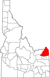 Location of Fremont County in Idaho
This is a list of the National Register of Historic Places listings in Fremont County, Idaho.
This is intended to be a complete list of the properties and districts on the National Register of Historic Places in Fremont County, Idaho, United States. Latitude and longitude coordinates are provided for many National Register properties and districts; these locations may be seen together in a Google map.[1]
There are 12 properties and districts listed on the National Register in the county. More may be added; properties and districts nationwide are added to the Register weekly.[2]
-
- This National Park Service list is complete through NPS recent listings posted November 10, 2011.[3]
Current listings
[4] Landmark name [5] Image Date listed Location City or town Summary 1 Big Falls Inn May 31, 2002 Western bank of Henrys Fork at Upper Mesa Falls in the Targhee National Forest
44°11′16″N 111°19′37″W / 44.187778°N 111.326944°WIsland Park 2 Bishop Mountain Lookout May 23, 1986 Forest Rd. 80120
44°20′03″N 111°33′09″W / 44.334167°N 111.5525°WIsland Park 3 Conant Creek Pegram Truss Railroad Bridge July 25, 1997 Over the Conant Creek, 1 mile south of the junction of Squirrel Rd. and old Ashton-Victor railroad spur tracks
44°00′52″N 111°21′51″W / 44.014444°N 111.364167°WGrainville 4 Glen and Addie Crabtree Cabin June 29, 2000 3939 Cowan Rd.
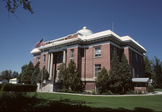
44°27′27″N 111°26′22″W / 44.4575°N 111.439444°WIsland Park 5 Fremont County Courthouse 
January 8, 1979 151 W. 1st St., N.
43°58′04″N 111°41′01″W / 43.967778°N 111.683611°WSt. Anthony 6 Idaho State Industrial School Women's Dormitory November 17, 1982 West of St. Anthony on N. Parker Highway
43°58′50″N 111°43′25″W / 43.980556°N 111.723611°WSt. Anthony 7 Independent Order of Odd Fellows Hall July 9, 1997 Junction of 6th Ave. and Main St.
44°03′46″N 111°26′39″W / 44.062778°N 111.444167°WAshton 8 Island Park Land and Cattle Company Home Ranch December 20, 1996 U.S. Route 20, approximately 1 mile southwest of Island Park
44°20′41″N 111°27′39″W / 44.344722°N 111.460833°WIsland Park 9 Johnny Sack Cabin April 19, 1979 Island Park
44°30′01″N 111°15′15″W / 44.500278°N 111.254167°WIsland Park 10 St. Anthony Pegram Truss Railroad Bridge July 25, 1997 Over Henry's Fork, 0.5 miles south of the junction of S. Parker Rd. and West Belt Branch railroad tracks
43°57′01″N 111°42′59″W / 43.950278°N 111.716389°WSt. Anthony 11 Joseph Sherwood House and Store December 9, 1994 State Highway 87 west of its junction with U.S. Route 20
44°39′57″N 111°23′08″W / 44.665833°N 111.385556°WIsland Park 12 US Post Office-St. Anthony Main March 16, 1989 48 W. 1st, N.
43°58′02″N 111°40′57″W / 43.967222°N 111.6825°WSt. Anthony See also
References
- ^ The latitude and longitude information provided in this table was derived originally from the National Register Information System, which has been found to be fairly accurate for about 99% of listings. For about 1% of NRIS original coordinates, experience has shown that one or both coordinates are typos or otherwise extremely far off; some corrections may have been made. A more subtle problem causes many locations to be off by up to 150 yards, depending on location in the country: most NRIS coordinates were derived from tracing out latitude and longitudes off of USGS topographical quadrant maps created under North American Datum of 1927, which differs from the current, highly accurate GPS system used by Google maps. Chicago is about right, but NRIS longitudes in Washington are higher by about 4.5 seconds, and are lower by about 2.0 seconds in Maine. Latitudes differ by about 1.0 second in Florida. Some locations in this table may have been corrected to current GPS standards.
- ^ "National Register of Historic Places: Weekly List Actions". National Park Service. http://www.cr.nps.gov/nr/nrlist.htm. Retrieved March 29, 2009.
- ^ "National Register of Historic Places: Weekly List Actions". National Park Service, United States Department of the Interior. Retrieved on November 10, 2011.
- ^ Numbers represent an ordering by significant words. Various colorings, defined here, differentiate National Historic Landmark sites and National Register of Historic Places Districts from other NRHP buildings, structures, sites or objects.
- ^ "National Register Information System". National Register of Historic Places. National Park Service. . http://nrhp.focus.nps.gov/natreg/docs/All_Data.html.
Properties on the National Register of Historic Places in Idaho  Ada • Adams • Bannock • Bear Lake • Benewah • Bingham • Blaine • Boise • Bonner • Bonneville • Boundary • Butte • Camas • Canyon • Caribou • Cassia • Clark • Clearwater • Custer • Elmore • Franklin • Fremont • Gem • Gooding • Idaho • Jefferson • Jerome • Kootenai • Latah • Lemhi • Lewis • Lincoln • Madison • Minidoka • Nez Perce • Oneida • Owyhee • Payette • Power • Shoshone • Teton • Twin Falls • Valley • Washington
U.S. National Register of Historic Places Topics Lists by states Alabama • Alaska • Arizona • Arkansas • California • Colorado • Connecticut • Delaware • Florida • Georgia • Hawaii • Idaho • Illinois • Indiana • Iowa • Kansas • Kentucky • Louisiana • Maine • Maryland • Massachusetts • Michigan • Minnesota • Mississippi • Missouri • Montana • Nebraska • Nevada • New Hampshire • New Jersey • New Mexico • New York • North Carolina • North Dakota • Ohio • Oklahoma • Oregon • Pennsylvania • Rhode Island • South Carolina • South Dakota • Tennessee • Texas • Utah • Vermont • Virginia • Washington • West Virginia • Wisconsin • WyomingLists by territories Lists by associated states Other  Category:National Register of Historic Places •
  Portal:National Register of Historic Places
Municipalities and communities of Fremont County, Idaho County seat: St. Anthony Cities Ashton | Drummond | Island Park | Newdale | Parker | St. Anthony | Teton | Warm River

Unincorporated
communitiesCategories:- National Register of Historic Places in Idaho by county
- Fremont County, Idaho
-


Wikimedia Foundation. 2010.