- National Register of Historic Places listings in Cassia County, Idaho
-
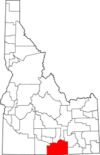 Location of Cassia County in Idaho
This is a list of the National Register of Historic Places listings in Cassia County, Idaho.
This is intended to be a complete list of the properties and districts on the National Register of Historic Places in Cassia County, Idaho, United States. Latitude and longitude coordinates are provided for many National Register properties and districts; these locations may be seen together in a Google map.[1]
There are 7 properties and districts listed on the National Register in the county, including 1 National Historic Landmark. More may be added; properties and districts nationwide are added to the Register weekly.[2]
-
- This National Park Service list is complete through NPS recent listings posted November 10, 2011.[3]
Current listings
[4] Landmark name [5] Image Date listed Location City or town Summary 1 Albion Methodist Church September 4, 1986 102 North St.
42°24′47″N 113°34′39″W / 42.413056°N 113.5775°WAlbion 2 Albion Normal School Campus November 28, 1980 Off State Highway 77
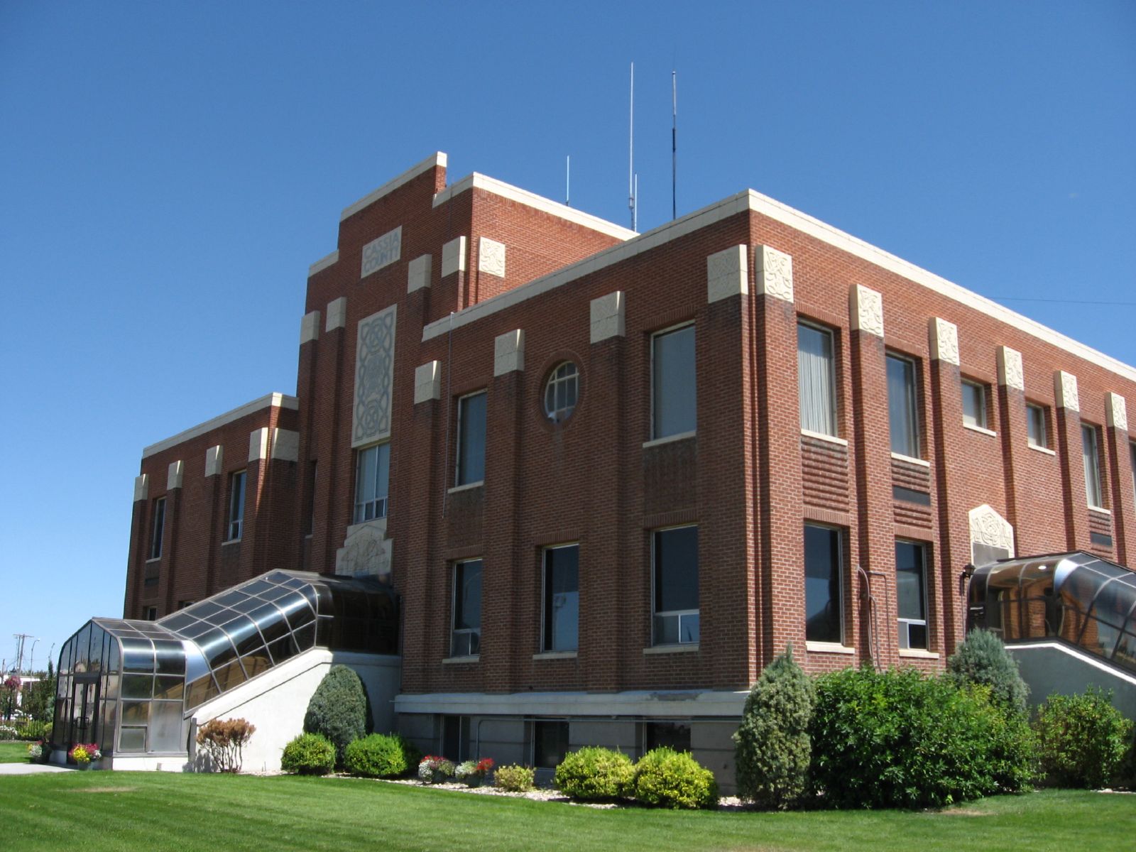
42°24′48″N 113°35′02″W / 42.413333°N 113.583889°WAlbion 3 Cassia County Courthouse 
September 27, 1987 15th St. and Overland Ave.
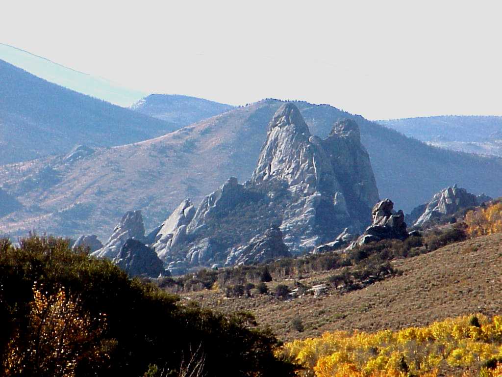
42°32′04″N 113°47′31″W / 42.534444°N 113.791944°WBurley 4 City of Rocks 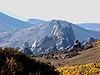
October 15, 1966 City of Rocks National Reserve
43°04′32″N 113°42′50″W / 43.075556°N 113.713889°WAlmo 5 Granite Pass June 28, 1972 Southwest of Burley, less than 0.5 miles north of the Utah boundary
41°59′32″N 113°51′3″W / 41.99222°N 113.85083°W[6]Burley 6 Oakley Historic District November 28, 1980 Main St. and Wilson Ave.
42°14′26″N 113°52′59″W / 42.240556°N 113.883056°WOakley 7 Swanger Hall September 20, 1978 Albion State Normal School campus
42°24′48″N 113°34′58″W / 42.413333°N 113.582778°WAlbion See also
References
- ^ The latitude and longitude information provided in this table was derived originally from the National Register Information System, which has been found to be fairly accurate for about 99% of listings. For about 1% of NRIS original coordinates, experience has shown that one or both coordinates are typos or otherwise extremely far off; some corrections may have been made. A more subtle problem causes many locations to be off by up to 150 yards, depending on location in the country: most NRIS coordinates were derived from tracing out latitude and longitudes off of USGS topographical quadrant maps created under the North American Datum of 1927, which differs from the current, highly accurate WGS84 GPS system used by Google maps. Chicago is about right, but NRIS longitudes in Washington are higher by about 4.5 seconds, and are lower by about 2.0 seconds in Maine. Latitudes differ by about 1.0 second in Florida. Some locations in this table may have been corrected to current GPS standards.
- ^ "National Register of Historic Places: Weekly List Actions". National Park Service. http://www.cr.nps.gov/nr/nrlist.htm. Retrieved March 29, 2009.
- ^ "National Register of Historic Places: Weekly List Actions". National Park Service, United States Department of the Interior. Retrieved on November 10, 2011.
- ^ Numbers represent an ordering by significant words. Various colorings, defined here, differentiate National Historic Landmark sites and National Register of Historic Places Districts from other NRHP buildings, structures, sites or objects.
- ^ "National Register Information System". National Register of Historic Places. National Park Service. . http://nrhp.focus.nps.gov/natreg/docs/All_Data.html.
- ^ Coordinates derived from its GNIS feature record; the NRIS provides the location but no coordinates
Properties on the National Register of Historic Places in Idaho  Ada • Adams • Bannock • Bear Lake • Benewah • Bingham • Blaine • Boise • Bonner • Bonneville • Boundary • Butte • Camas • Canyon • Caribou • Cassia • Clark • Clearwater • Custer • Elmore • Franklin • Fremont • Gem • Gooding • Idaho • Jefferson • Jerome • Kootenai • Latah • Lemhi • Lewis • Lincoln • Madison • Minidoka • Nez Perce • Oneida • Owyhee • Payette • Power • Shoshone • Teton • Twin Falls • Valley • Washington
U.S. National Register of Historic Places Topics Lists by states Alabama • Alaska • Arizona • Arkansas • California • Colorado • Connecticut • Delaware • Florida • Georgia • Hawaii • Idaho • Illinois • Indiana • Iowa • Kansas • Kentucky • Louisiana • Maine • Maryland • Massachusetts • Michigan • Minnesota • Mississippi • Missouri • Montana • Nebraska • Nevada • New Hampshire • New Jersey • New Mexico • New York • North Carolina • North Dakota • Ohio • Oklahoma • Oregon • Pennsylvania • Rhode Island • South Carolina • South Dakota • Tennessee • Texas • Utah • Vermont • Virginia • Washington • West Virginia • Wisconsin • WyomingLists by territories Lists by associated states Other Municipalities and communities of Cassia County, Idaho Cities 
Unincorporated
communitiesAlmo | Idahome | Raft River
Footnotes ‡This populated place also has portions in an adjacent county or counties
Categories:- National Register of Historic Places in Idaho by county
- Cassia County, Idaho
-


Wikimedia Foundation. 2010.