- National Register of Historic Places listings in Bonneville County, Idaho
-
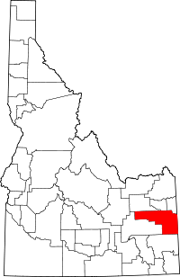 Location of Bonneville County in Idaho
This is a list of the National Register of Historic Places listings in Bonneville County, Idaho.
This is intended to be a complete list of the properties and districts on the National Register of Historic Places in Bonneville County, Idaho, United States. Latitude and longitude coordinates are provided for many National Register properties and districts; these locations may be seen together in a Google map.[1]
There are 31 properties and districts listed on the National Register in the county. More may be added; properties and districts nationwide are added to the Register weekly.[2]
-
- This National Park Service list is complete through NPS recent listings posted November 10, 2011.[3]
Current listings
[4] Landmark name [5] Image Date listed Location City or town Summary 1 Andrew and Johanna M. Beckman Farm November 6, 1992 U.S. Route 20, 0.5 miles west of its junction with New Sweden Rd.
43°29′37″N 112°08′12″W / 43.493611°N 112.136667°WIdaho Falls 2 Oscar and Christina Beckman Farmstead November 19, 1991 Southwestern corner of the junction of New Sweden-Shelley Rd. and U.S. Route 20
43°29′38″N 112°07′28″W / 43.493889°N 112.124444°WIdaho Falls 3 Bonneville County Courthouse July 10, 1979 Capital Ave. and C St.
43°29′42″N 112°02′25″W / 43.495°N 112.040278°WIdaho Falls 4 Bonneville Hotel 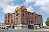
August 30, 1984 400 block of W. C St.
43°29′41″N 112°02′19″W / 43.494722°N 112.038611°WIdaho Falls 5 Douglas-Farr Building August 30, 1984 493 N. Capital Ave.
43°29′38″N 112°02′25″W / 43.493889°N 112.040278°WIdaho Falls 6 Eagle Rock Ferry June 7, 1974 North of Idaho Falls on the Snake River
43°36′15″N 112°03′23″W / 43.604167°N 112.056389°WIdaho Falls 7 Eleventh Street Historic District August 8, 1997 Roughly bounded by S. Boulevard, 13th, 10th, and 9th Sts., S. Emerson and S. Lee Aves.
43°29′18″N 112°01′47″W / 43.488333°N 112.029722°WIdaho Falls 8 Farmers and Merchants Bank Building August 30, 1984 383 W. A St.
43°29′31″N 112°02′24″W / 43.491944°N 112.04°WIdaho Falls 9 First Presbyterian Church March 29, 1978 325 Elm St.
43°29′22″N 112°02′06″W / 43.489444°N 112.035°WIdaho Falls 10 Hasbrouck Building August 30, 1984 362 Park Ave.
43°29′33″N 112°02′24″W / 43.4925°N 112.04°WIdaho Falls 11 Holy Rosary Church July 17, 2002 288 E. 9th St.
43°29′22″N 112°01′47″W / 43.489444°N 112.029722°WIdaho Falls 12 Hotel Idaho August 30, 1984 482 W. C St.
43°29′42″N 112°02′22″W / 43.495°N 112.039444°WIdaho Falls 13 I.O.O.F. Building August 30, 1984 393 N. Park Ave.
43°52′28″N 112°02′49″W / 43.874444°N 112.046944°WIdaho Falls 14 Idaho Falls Airport Historic District September 10, 1997 2381 Foote Dr.
43°31′02″N 112°03′30″W / 43.517222°N 112.058333°WIdaho Falls 15 Idaho Falls City Building August 30, 1984 303 W. C St.
43°29′39″N 112°02′15″W / 43.494167°N 112.0375°WIdaho Falls 16 Idaho Falls Public Library August 30, 1984 200 N. Eastern Dr.
43°29′25″N 112°02′14″W / 43.490278°N 112.037222°WIdaho Falls 17 Iona Meetinghouse May 7, 1973 In Iona
43°31′41″N 111°55′42″W / 43.528056°N 111.928333°WIona 18 Kress Building August 30, 1984 451 N. Park Ave.
43°29′36″N 112°02′24″W / 43.493333°N 112.04°WIdaho Falls 19 Montgomery Ward Building August 30, 1984 504 Shoup Ave.
43°29′35″N 112°02′16″W / 43.493056°N 112.037778°WIdaho Falls 20 New Sweden School November 19, 1991 Southwestern corner of the junction of New Sweden School Rd. and Mill Rd.
43°28′56″N 112°06′07″W / 43.482222°N 112.101944°WIdaho Falls 21 Ridge Avenue Historic District May 20, 1993 Roughly bounded by N. Eastern Ave., Birch St., S. Boulevard, Ash St., W. Placer Ave., and Pine St.
43°29′24″N 112°02′07″W / 43.49°N 112.035278°WIdaho Falls 22 Rocky Mountain Bell Telephone Company Building August 30, 1984 246 W. Broadway Ave.
43°29′29″N 112°02′20″W / 43.491389°N 112.038889°WIdaho Falls 23 Salt River Hydroelectric Powerplant December 2, 1993 End of County Road 12-104, 0.7 miles west of U.S. Route 89
43°06′14″N 111°02′20″W / 43.103889°N 111.038889°WWayan Extends into Lincoln County, Wyoming 24 Carl S. and Lizzie Sealander Farmstead May 5, 1992 Western end of St. John Rd.
43°26′30″N 112°09′57″W / 43.441667°N 112.165833°WIdaho Falls 25 Shane Building August 30, 1984 381 N. Shoup Ave.
43°29′32″N 112°02′21″W / 43.492222°N 112.039167°WIdaho Falls 26 Shelton L.D.S. Ward Chapel August 30, 1979 Southwest of Ririe on Shelton Rd
43°37′07″N 111°49′23″W / 43.618611°N 111.823056°WRirie 27 Trinity Methodist Church December 16, 1977 237 N. Water Ave.
43°29′25″N 112°02′13″W / 43.490278°N 112.036944°WIdaho Falls 28 Art Troutner Houses Historic District September 10, 2008 3950, 4012, and 4032 S. 5th, W.
43°31′34″N 112°01′25″W / 43.52616°N 112.02358°WIdaho Falls 29 U.S. Post Office May 31, 1979 581 Park Ave.
43°29′40″N 112°02′20″W / 43.494444°N 112.038889°WIdaho Falls 30 Underwood Hotel August 30, 1984 343-349 W. C St.
43°29′38″N 112°02′17″W / 43.493889°N 112.038056°WIdaho Falls 31 Wasden Site (Owl Cave) May 24, 1976 Address Restricted[6] Idaho Falls See also
References
- ^ The latitude and longitude information provided in this table was derived originally from the National Register Information System, which has been found to be fairly accurate for about 99% of listings. For about 1% of NRIS original coordinates, experience has shown that one or both coordinates are typos or otherwise extremely far off; some corrections may have been made. A more subtle problem causes many locations to be off by up to 150 yards, depending on location in the country: most NRIS coordinates were derived from tracing out latitude and longitudes off of USGS topographical quadrant maps created under the North American Datum of 1927, which differs from the current, highly accurate WGS84 GPS system used by Google maps. Chicago is about right, but NRIS longitudes in Washington are higher by about 4.5 seconds, and are lower by about 2.0 seconds in Maine. Latitudes differ by about 1.0 second in Florida. Some locations in this table may have been corrected to current GPS standards.
- ^ "National Register of Historic Places: Weekly List Actions". National Park Service. http://www.cr.nps.gov/nr/nrlist.htm. Retrieved March 29, 2009.
- ^ "National Register of Historic Places: Weekly List Actions". National Park Service, United States Department of the Interior. Retrieved on November 10, 2011.
- ^ Numbers represent an ordering by significant words. Various colorings, defined here, differentiate National Historic Landmark sites and National Register of Historic Places Districts from other NRHP buildings, structures, sites or objects.
- ^ "National Register Information System". National Register of Historic Places. National Park Service. . http://nrhp.focus.nps.gov/natreg/docs/All_Data.html.
- ^ Some listings on the NRHP are highly sensitive sites and may be subject to looting or vandalism. The NRHP lists this site as "Address Restricted."
Properties on the National Register of Historic Places in Idaho  Ada • Adams • Bannock • Bear Lake • Benewah • Bingham • Blaine • Boise • Bonner • Bonneville • Boundary • Butte • Camas • Canyon • Caribou • Cassia • Clark • Clearwater • Custer • Elmore • Franklin • Fremont • Gem • Gooding • Idaho • Jefferson • Jerome • Kootenai • Latah • Lemhi • Lewis • Lincoln • Madison • Minidoka • Nez Perce • Oneida • Owyhee • Payette • Power • Shoshone • Teton • Twin Falls • Valley • Washington
U.S. National Register of Historic Places Topics Lists by states Alabama • Alaska • Arizona • Arkansas • California • Colorado • Connecticut • Delaware • Florida • Georgia • Hawaii • Idaho • Illinois • Indiana • Iowa • Kansas • Kentucky • Louisiana • Maine • Maryland • Massachusetts • Michigan • Minnesota • Mississippi • Missouri • Montana • Nebraska • Nevada • New Hampshire • New Jersey • New Mexico • New York • North Carolina • North Dakota • Ohio • Oklahoma • Oregon • Pennsylvania • Rhode Island • South Carolina • South Dakota • Tennessee • Texas • Utah • Vermont • Virginia • Washington • West Virginia • Wisconsin • WyomingLists by territories Lists by associated states Other Municipalities and communities of Bonneville County, Idaho Cities Ammon | Idaho Falls | Iona | Irwin | Ririe‡ | Swan Valley | Ucon

CDP Lincoln
Unincorporated
communitiesBeachs Corner | Osgood
Footnotes ‡This populated place also has portions in an adjacent county or counties
Categories:- National Register of Historic Places in Idaho by county
- Bonneville County, Idaho
-


Wikimedia Foundation. 2010.