- National Register of Historic Places listings in Benewah County, Idaho
-
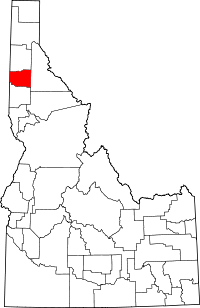 Location of Benewah County in Idaho
This is a list of the National Register of Historic Places listings in Benewah County, Idaho.
This is intended to be a complete list of the properties on the National Register of Historic Places in Benewah County, Idaho, United States. Latitude and longitude coordinates are provided for many National Register properties and districts; these locations may be seen together in a Google map.[1]
There are 9 properties listed on the National Register in the county. More may be added; properties and districts nationwide are added to the Register weekly.[2]
-
- This National Park Service list is complete through NPS recent listings posted November 10, 2011.[3]
Current listings
[4] Landmark name [5] Image Date listed Location City or town Summary 1 Benewah County Courthouse September 22, 1987 College Ave. and 7th St.
47°18′55″N 116°33′57″W / 47.315278°N 116.565833°WSt. Maries 2 Chatcolet CCC Picnic and Camping Area February 1, 1995 State Highway 5 in Heyburn State Park
47°22′34″N 116°45′39″W / 47.376111°N 116.760833°WChatcolet 3 Coeur d'Alene Mission of the Sacred Heart April 21, 1975 Off U.S. Route 95
47°08′46″N 116°54′49″W / 47.146111°N 116.913611°WDesmet 4 Kootenai Inn November 16, 1979 130 N. 9th St.
47°19′02″N 116°34′05″W / 47.317222°N 116.568056°WSt. Maries 5 Mullan Road 
April 5, 1990 3 segments: between Aldar Creek and Cedar Creek; Fourth of July Pass between Interstate 80 and old U.S. Route 10; and Heyburn State Park
47°31′32″N 116°37′36″W / 47.525556°N 116.626667°WSt. Maries Extends into Kootenai County 6 Plummer Point CCC Picnic and Hiking Area February 1, 1995 State Highway 5 in Heyburn State Park
47°21′44″N 116°46′38″W / 47.362222°N 116.777222°WChatcolet 7 Rocky Point CCC Properties February 1, 1995 State Highway 5 in Heyburn State Park
47°21′16″N 116°44′54″W / 47.354444°N 116.748333°WChatcolet 8 St. Maries 1910 Fire Memorial September 20, 1984 St. Maries Cemetery
47°18′57″N 116°35′10″W / 47.315833°N 116.586111°WSt. Maries North Idaho 1910 Fire Sites TR 9 St. Maries Masonic Temple No. 63 September 23, 2011 208 S. 8th St.
47°18′55″N 116°34′04″W / 47.315278°N 116.567778°WSt. Maries See also
References
- ^ The latitude and longitude information provided in this table was derived originally from the National Register Information System, which has been found to be fairly accurate for about 99% of listings. For about 1% of NRIS original coordinates, experience has shown that one or both coordinates are typos or otherwise extremely far off; some corrections may have been made. A more subtle problem causes many locations to be off by up to 150 yards, depending on location in the country: most NRIS coordinates were derived from tracing out latitude and longitudes off of USGS topographical quadrant maps created under North American Datum of 1927, which differs from the current, highly accurate GPS system used by Google maps. Chicago is about right, but NRIS longitudes in Washington are higher by about 4.5 seconds, and are lower by about 2.0 seconds in Maine. Latitudes differ by about 1.0 second in Florida. Some locations in this table may have been corrected to current GPS standards.
- ^ "National Register of Historic Places: Weekly List Actions". National Park Service. http://www.cr.nps.gov/nr/nrlist.htm. Retrieved March 29, 2009.
- ^ "National Register of Historic Places: Weekly List Actions". National Park Service, United States Department of the Interior. Retrieved on November 10, 2011.
- ^ Numbers represent an ordering by significant words. Various colorings, defined here, differentiate National Historic Landmark sites and National Register of Historic Places Districts from other NRHP buildings, structures, sites or objects.
- ^ "National Register Information System". National Register of Historic Places. National Park Service. . http://nrhp.focus.nps.gov/natreg/docs/All_Data.html.
Properties on the National Register of Historic Places in Idaho  Ada • Adams • Bannock • Bear Lake • Benewah • Bingham • Blaine • Boise • Bonner • Bonneville • Boundary • Butte • Camas • Canyon • Caribou • Cassia • Clark • Clearwater • Custer • Elmore • Franklin • Fremont • Gem • Gooding • Idaho • Jefferson • Jerome • Kootenai • Latah • Lemhi • Lewis • Lincoln • Madison • Minidoka • Nez Perce • Oneida • Owyhee • Payette • Power • Shoshone • Teton • Twin Falls • Valley • Washington
U.S. National Register of Historic Places Topics Lists by states Alabama • Alaska • Arizona • Arkansas • California • Colorado • Connecticut • Delaware • Florida • Georgia • Hawaii • Idaho • Illinois • Indiana • Iowa • Kansas • Kentucky • Louisiana • Maine • Maryland • Massachusetts • Michigan • Minnesota • Mississippi • Missouri • Montana • Nebraska • Nevada • New Hampshire • New Jersey • New Mexico • New York • North Carolina • North Dakota • Ohio • Oklahoma • Oregon • Pennsylvania • Rhode Island • South Carolina • South Dakota • Tennessee • Texas • Utah • Vermont • Virginia • Washington • West Virginia • Wisconsin • WyomingLists by territories Lists by associated states Other  Category:National Register of Historic Places •
  Portal:National Register of Historic Places
Municipalities and communities of Benewah County, Idaho County seat: St. Maries Cities Plummer | St. Maries | Tensed

CDPs Unincorporated
communitiesIndian reservation Footnotes ‡This populated place also has portions in an adjacent county or counties
Categories:- National Register of Historic Places in Idaho by county
- Benewah County, Idaho
-


Wikimedia Foundation. 2010.