- National Register of Historic Places listings in Washington County, Idaho
-
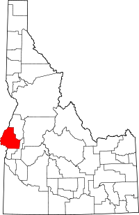 Location of Washington County in Idaho
This is a list of the National Register of Historic Places listings in Washington County, Idaho.
This is intended to be a complete list of the properties and districts on the National Register of Historic Places in Washington County, Idaho, United States. Latitude and longitude coordinates are provided for many National Register properties and districts; these locations may be seen together in a Google map.[1]
There are 29 properties and districts listed on the National Register in the county. More may be added; properties and districts nationwide are added to the Register weekly.[2]
-
- This National Park Service list is complete through NPS recent listings posted November 10, 2011.[3]
Current listings
[4] Landmark name [5] Image Date listed Location City or town Summary 1 Anderson-Elwell House November 17, 1982 547 W. 1st St.
44°14′51″N 116°58′12″W / 44.2475°N 116.97°WWeiser 2 Baptist Church October 7, 1977 E. Main and 8th Sts.
44°14′46″N 116°57′18″W / 44.246111°N 116.955°WWeiser 3 Butterfield Livestock Company House November 17, 1982 North of Weiser on Jenkins Creek Rd.
44°15′30″N 116°59′35″W / 44.258333°N 116.993056°WWeiser 4 Cambridge News Office December 28, 1989 155 N. Superior St.
44°34′24″N 116°40′27″W / 44.573333°N 116.674167°WCambridge 5 Col. C.F. Drake House January 20, 1978 516 E. Main St.
44°14′49″N 116°57′33″W / 44.246944°N 116.959167°WWeiser 6 Edwards-Gillette Barn February 19, 2002 3059 Rush Creek Rd.
44°35′37″N 116°42′05″W / 44.593611°N 116.701389°WCambridge 7 James M. Fisher House September 4, 1986 598 Pioneer Rd.
44°15′12″N 116°58′34″W / 44.253333°N 116.976111°WWeiser 8 Thomas C. Galloway House January 26, 1978 1120 E. 2nd St.
44°15′10″N 116°57′56″W / 44.252778°N 116.965556°WWeiser 9 Bernard Haas House May 22, 1978 377 E. Main St.
44°14′44″N 116°57′47″W / 44.245556°N 116.963056°WWeiser 10 Herman Haas House November 17, 1982 253 W. Idaho St.
44°14′47″N 116°58′22″W / 44.246389°N 116.972778°WWeiser 11 Intermountain Institute November 1, 1979 Paddock Ave.
44°15′56″N 116°58′49″W / 44.265556°N 116.980278°WWeiser 12 Jewell Building January 18, 1990 15 N. Superior
44°34′19″N 116°40′33″W / 44.571944°N 116.675833°WCambridge 13 Knights of Pythias Lodge Hall May 13, 1976 30 E. Idaho St.
44°14′47″N 116°58′05″W / 44.246389°N 116.968056°WWeiser 14 Kurtz-Van Sicklin House November 17, 1982 439 W. 3rd. St.
44°14′50″N 116°58′21″W / 44.247222°N 116.9725°WWeiser 15 Archie Larsen House November 17, 1982 South of Weiser on Larsen Rd.
44°11′44″N 116°56′05″W / 44.195556°N 116.934722°WWeiser 16 G.V. Nesbit House November 17, 1982 308 W. Liberty
44°14′58″N 116°58′19″W / 44.249444°N 116.971944°WWeiser 17 Dr. J.R. Numbers House November 17, 1982 240 W. Main St.
44°14′51″N 116°58′19″W / 44.2475°N 116.971944°WWeiser 18 St. Agnes Catholic Church July 24, 1978 204 E. Liberty St.
44°14′53″N 116°57′56″W / 44.248056°N 116.965556°WWeiser 19 St. Luke's Episcopal Church July 24, 1978 E. 1st and Liberty Sts.
44°14′53″N 116°57′59″W / 44.248056°N 116.966389°WWeiser 20 Salubria Lodge No. 31 March 9, 1990 85 W. Central St.
44°34′23″N 116°40′32″W / 44.573056°N 116.675556°WCambridge 21 Morris Sommer House November 17, 1982 548 W. 2nd St.
44°14′52″N 116°58′17″W / 44.247778°N 116.971389°WWeiser 22 Mary Elizabeth Sommercamp House November 17, 1982 411 W. 3rd St.
44°14′49″N 116°58′24″W / 44.246944°N 116.973333°WWeiser 23 Star Theater November 30, 1999 342 State St.
44°14′43″N 116°58′10″W / 44.245278°N 116.969444°WWeiser 24 B.S. Varian House November 17, 1982 241 Main St.
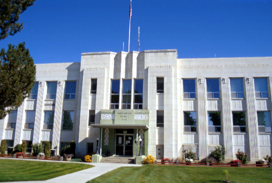
44°14′49″N 116°58′19″W / 44.246944°N 116.971944°WWeiser 25 Washington County Courthouse 
September 28, 1987 E. Court St.
44°14′51″N 116°57′55″W / 44.2475°N 116.965278°WWeiser 26 Benjamin Watlington House April 26, 1991 206 W. Court St.
44°14′53″N 116°58′16″W / 44.248056°N 116.971111°WWeiser 27 Weiser Oregon Short Line Railroad Depot February 7, 2007 One State St.
44°14′45″N 116°58′16″W / 44.245833°N 116.971111°WWeiser 28 Weiser Post Office November 17, 1982 Main and W. 1st Sts.
44°14′49″N 116°58′13″W / 44.246944°N 116.970278°WWeiser 29 Wilson House January 6, 2004 75 N. 5th St.
44°34′33″N 116°40′50″W / 44.575833°N 116.680556°WCambridge See also
References
- ^ The latitude and longitude information provided in this table was derived originally from the National Register Information System, which has been found to be fairly accurate for about 99% of listings. For about 1% of NRIS original coordinates, experience has shown that one or both coordinates are typos or otherwise extremely far off; some corrections may have been made. A more subtle problem causes many locations to be off by up to 150 yards, depending on location in the country: most NRIS coordinates were derived from tracing out latitude and longitudes off of USGS topographical quadrant maps created under the North American Datum of 1927, which differs from the current, highly accurate WGS84 GPS system used by Google maps. Chicago is about right, but NRIS longitudes in Washington are higher by about 4.5 seconds, and are lower by about 2.0 seconds in Maine. Latitudes differ by about 1.0 second in Florida. Some locations in this table may have been corrected to current GPS standards.
- ^ "National Register of Historic Places: Weekly List Actions". National Park Service. http://www.cr.nps.gov/nr/nrlist.htm. Retrieved March 29, 2009.
- ^ "National Register of Historic Places: Weekly List Actions". National Park Service, United States Department of the Interior. Retrieved on November 10, 2011.
- ^ Numbers represent an ordering by significant words. Various colorings, defined here, differentiate National Historic Landmark sites and National Register of Historic Places Districts from other NRHP buildings, structures, sites or objects.
- ^ "National Register Information System". National Register of Historic Places. National Park Service. . http://nrhp.focus.nps.gov/natreg/docs/All_Data.html.
Properties on the National Register of Historic Places in Idaho  Ada • Adams • Bannock • Bear Lake • Benewah • Bingham • Blaine • Boise • Bonner • Bonneville • Boundary • Butte • Camas • Canyon • Caribou • Cassia • Clark • Clearwater • Custer • Elmore • Franklin • Fremont • Gem • Gooding • Idaho • Jefferson • Jerome • Kootenai • Latah • Lemhi • Lewis • Lincoln • Madison • Minidoka • Nez Perce • Oneida • Owyhee • Payette • Power • Shoshone • Teton • Twin Falls • Valley • Washington
U.S. National Register of Historic Places Topics Lists by states Alabama • Alaska • Arizona • Arkansas • California • Colorado • Connecticut • Delaware • Florida • Georgia • Hawaii • Idaho • Illinois • Indiana • Iowa • Kansas • Kentucky • Louisiana • Maine • Maryland • Massachusetts • Michigan • Minnesota • Mississippi • Missouri • Montana • Nebraska • Nevada • New Hampshire • New Jersey • New Mexico • New York • North Carolina • North Dakota • Ohio • Oklahoma • Oregon • Pennsylvania • Rhode Island • South Carolina • South Dakota • Tennessee • Texas • Utah • Vermont • Virginia • Washington • West Virginia • Wisconsin • WyomingLists by territories Lists by associated states Other Municipalities and communities of Washington County, Idaho Cities  Categories:
- National Register of Historic Places in Idaho by county
- Washington County, Idaho
-


Wikimedia Foundation. 2010.