- National Register of Historic Places listings in Death Valley National Park
-
This is a list of the National Register of Historic Places listings in Death Valley National Park.
This is intended to be a complete list of the properties and districts on the National Register of Historic Places in Death Valley National Park, Arizona, United States. The locations of National Register properties and districts for which the latitude and longitude coordinates are included below, may be seen in a Google map.[1]
There are five properties and districts listed on the National Register in the park.
-
- This National Park Service list is complete through NPS recent listings posted November 10, 2011.[2]
Current listings
[3] Landmark name[4] Image Date listed Location City or Town Summary 1 Death Valley Scotty Historic District 
July 20, 1978 On State Route 72, Death Valley National Park
37°1′33″N 117°22′2″W / 37.02583°N 117.36722°WGrapevine Canyon
Death Valley National Park2 Eagle Borax Works 
December 31, 1974 Death Valley National Park
36°12′4″N 116°51′54″W / 36.20111°N 116.865°WFurnace Creek
Death Valley National Park3 Harmony Borax Works 
December 31, 1974 Death Valley National Park
35°29′16″N 116°52′26″W / 35.48778°N 116.87389°WStovepipe Wells
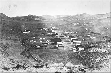
Death Valley National Park4 Leadfield 
June 10, 1975 Death Valley National Park, on Titus Canyon Trail
36°50′50″N 117°3′27″W / 36.84722°N 117.0575°WTitus Canyon,
Grapevine Mountains
Death Valley National Park5 Skidoo 
April 16, 1974 Death Valley National Park, Wildrose District
36°25′59″N 117°7′46″W / 36.43306°N 117.12944°WPanamint Range
Death Valley National ParkSee also
- National Register of Historic Places listings in Inyo County, California
- List of National Historic Landmarks in California
- National Register of Historic Places listings in California
References
- ^ The latitude and longitude information provided in this table was derived originally from the National Register Information System, which has been found to be fairly accurate for about 99% of listings. For about 1% of NRIS original coordinates, experience has shown that one or both coordinates are typos or otherwise extremely far off; some corrections may have been made. A more subtle problem causes many locations to be off by up to 150 yards, depending on location in the country: most NRIS coordinates were derived from tracing out latitude and longitudes off of USGS topographical quadrant maps created under the North American Datum of 1927, which differs from the current, highly accurate WGS84 GPS system used by Google maps. Chicago is about right, but NRIS longitudes in Washington are higher by about 4.5 seconds, and are lower by about 2.0 seconds in Maine. Latitudes differ by about 1.0 second in Florida. Some locations in this table may have been corrected to current GPS standards.
- ^ "National Register of Historic Places: Weekly List Actions". National Park Service, United States Department of the Interior. Retrieved on November 10, 2011.
- ^ Numbers represent an ordering by significant words. Various colorings, defined here, differentiate National Historic Landmark sites and National Register of Historic Places Districts from other NRHP buildings, structures, sites or objects.
- ^ "National Register Information System". National Register of Historic Places. National Park Service. 2008-04-24. http://nrhp.focus.nps.gov/natreg/docs/All_Data.html.
National Register of Historic Places in Death Valley National Park Historic districts Death Valley Scotty Historic District | Eagle Borax Works | Harmony Borax Works | Leadfield | Skidoo
See also: National Register of Historic Places listings in Death Valley National ParkU.S. National Register of Historic Places Topics Lists by states Alabama • Alaska • Arizona • Arkansas • California • Colorado • Connecticut • Delaware • Florida • Georgia • Hawaii • Idaho • Illinois • Indiana • Iowa • Kansas • Kentucky • Louisiana • Maine • Maryland • Massachusetts • Michigan • Minnesota • Mississippi • Missouri • Montana • Nebraska • Nevada • New Hampshire • New Jersey • New Mexico • New York • North Carolina • North Dakota • Ohio • Oklahoma • Oregon • Pennsylvania • Rhode Island • South Carolina • South Dakota • Tennessee • Texas • Utah • Vermont • Virginia • Washington • West Virginia • Wisconsin • WyomingLists by territories Lists by associated states Other Categories:- Inyo County, California
- Buildings and structures in Death Valley National Park
- National Register of Historic Places lists in the National Park Service
-


Wikimedia Foundation. 2010.