- National Register of Historic Places listings in DeWitt County, Texas
-
List of Registered Historic Places in DeWitt County, Texas
This is intended to be a complete list of properties and districts listed on the National Register of Historic Places in DeWitt County, Texas. The locations of National Register properties and districts (at least for all showing latitude and longitude coordinates below) may be seen in a Google map by clicking on "Map of all coordinates".[1]
-
- This National Park Service list is complete through NPS recent listings posted November 10, 2011.[2]
[3] Landmark name [4] Image Date listed Location City or town Summary 1 Bates-Sheppard House October 31, 1988 312 E. Broadway
29°05′33″N 97°17′11″W / 29.0925°N 97.286389°WCuero 2 John Y. Bell House October 31, 1988 304 E. Prairie
29°05′46″N 97°17′07″W / 29.096111°N 97.285278°WCuero 3 M. D. Bennett House October 31, 1988 208 N. Hunt
29°05′24″N 97°17′12″W / 29.09°N 97.286667°WCuero 4 Billow-Thompson House October 31, 1988 402 E. Broadway
29°05′32″N 97°17′09″W / 29.092222°N 97.285833°WCuero 5 Breeden-Runge Wholesale Grocery Company Building October 31, 1988 108 N. Frederick William
29°05′32″N 97°17′43″W / 29.092222°N 97.295278°WCuero 6 Floyd Buchel House October 31, 1988 407 E. Broadway
29°05′29″N 97°17′09″W / 29.091389°N 97.285833°WCuero 7 Arthur Burns House October 31, 1988 130 E. Sarah
29°05′44″N 97°17′14″W / 29.095556°N 97.287222°WCuero 8 John W. Burns House October 31, 1988 311 E. Broadway
29°05′31″N 97°17′13″W / 29.091944°N 97.286944°WCuero 9 Callaway-Gillette House October 31, 1988 306 E. Sarah
29°05′42″N 97°17′07″W / 29.095°N 97.285278°WCuero 10 J. B. Chaddock House October 31, 1988 202 S. Valley
29°05′10″N 97°17′06″W / 29.086111°N 97.285°WCuero 11 City Water Works October 31, 1988 208 S. Esplanade
29°05′21″N 97°17′33″W / 29.089167°N 97.2925°WCuero 12 Clement-Nagel House October 31, 1988 701 E. Morgan
29°05′07″N 97°17′10″W / 29.085278°N 97.286111°WCuero 13 Colston-Gohmert House October 31, 1988 309 E. Prairie
29°05′44″N 97°17′06″W / 29.095556°N 97.285°WCuero 14 Charles Cook House October 31, 1988 103 E. Sarah
29°05′44″N 97°17′17″W / 29.095556°N 97.288056°WCuero 15 W. H. Crain House October 31, 1988 508 E. Courthouse
29°05′24″N 97°17′06″W / 29.09°N 97.285°WCuero 16 Cuero Commercial Historic District November 17, 1988 Roughly bounded by Gonzales, Main, Terrell and Courthouse
29°05′28″N 97°17′27″W / 29.091111°N 97.290833°WCuero 17 Cuero Gin October 31, 1988 501 W. Main
29°05′30″N 97°17′44″W / 29.091667°N 97.295556°WCuero 18 Cuero High School October 31, 1988 405 E. Sarah
29°05′55″N 97°17′04″W / 29.098611°N 97.284444°WCuero 19 Cuero Hydroelectric Plant September 19, 1977 2 mi (3.2 km). N of Cuero on Guadalupe Plant
29°07′46″N 97°18′40″W / 29.129444°N 97.311111°WCuero 20 Cuero I Archeological District October 9, 1974 Address Restricted Cuero 21 E. A. Daule House October 31, 1988 201 W. Newman
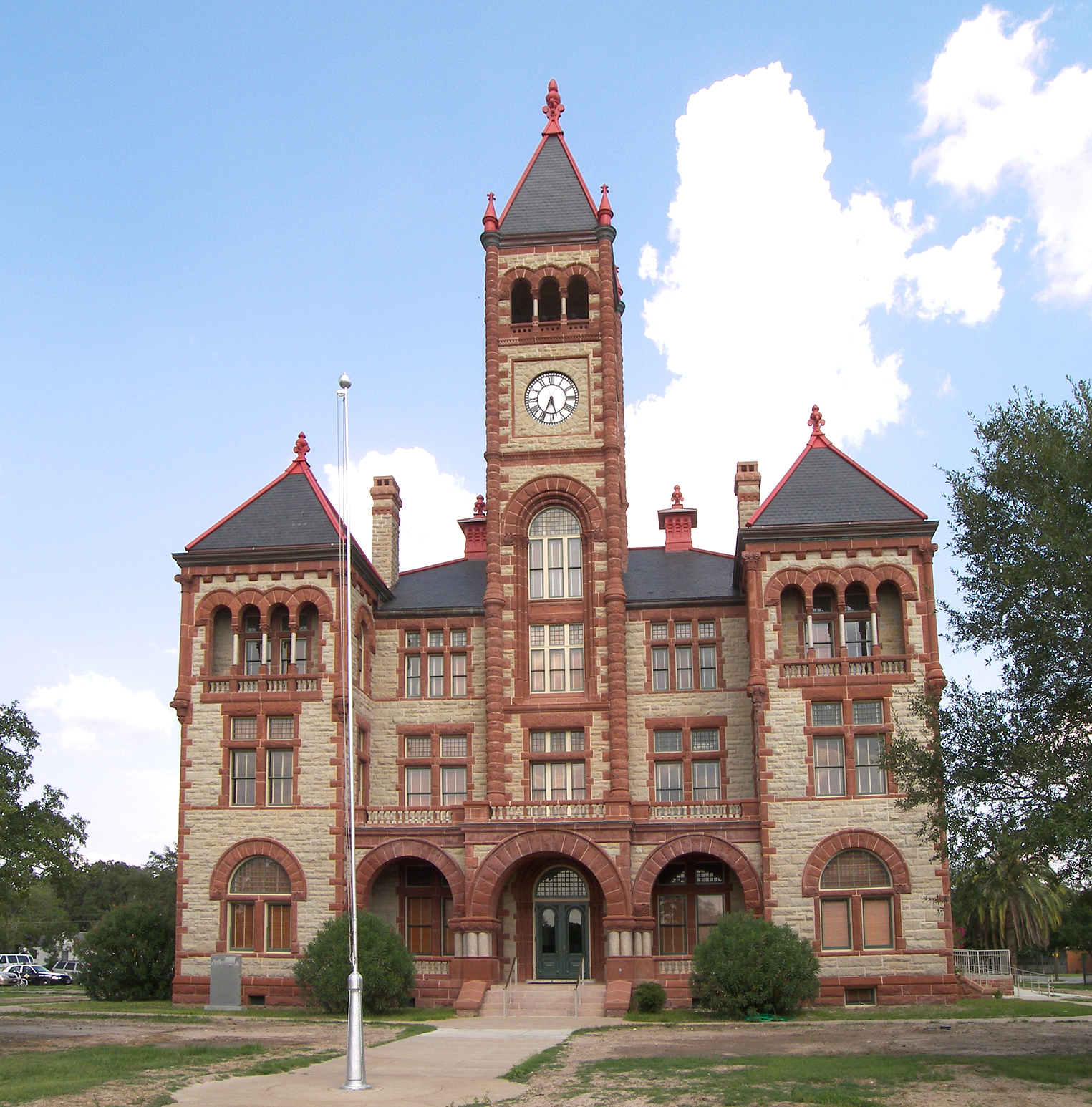
29°05′23″N 97°17′52″W / 29.089722°N 97.297778°WCuero 22 De Witt County Courthouse 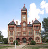
May 6, 1971 Bounded by N. Gonzales, E. Live Oak, N. Clinton, and E. Courthouse Sts.
29°05′29″N 97°17′19″W / 29.091389°N 97.288611°WCuero 23 East Main Street Residential Historic District October 31, 1988 400 to 800 blks. of E. Main St.
29°05′16″N 97°17′07″W / 29.087778°N 97.285278°WCuero 24 Eckhardt Stores June 29, 1976 Eckhardt and Main St.
28°58′49″N 97°30′13″W / 28.980278°N 97.503611°WYorktown 25 William and L. F. Eichholz House October 31, 1988 308 E. Courthouse
29°05′35″N 97°17′37″W / 29.093056°N 97.293611°WCuero 26 English-German School October 31, 1988 201 E. Newman
29°05′09″N 97°17′30″W / 29.085833°N 97.291667°WCuero 27 J. B. Farris House October 31, 1988 502 N. Gonzales
29°05′36″N 97°17′18″W / 29.093333°N 97.288333°WCuero 28 First Methodist Church October 31, 1988 301 E. Courthouse
29°05′27″N 97°17′17″W / 29.090833°N 97.288056°WCuero 29 Alfred Friar House October 31, 1988 703 N. Gonzales
29°05′42″N 97°17′13″W / 29.095°N 97.286944°WCuero 30 William Frobese Sr. October 31, 1988 305 E. Newman
29°05′07″N 97°17′24″W / 29.085278°N 97.29°WCuero 31 Grace Episcopal Church October 31, 1988 401 N. Esplanade
29°05′33″N 97°17′23″W / 29.0925°N 97.289722°WCuero 32 House at 1002 Stockdale October 31, 1988 1002 Stockdale
29°04′47″N 97°17′37″W / 29.079722°N 97.293611°WCuero 33 House at 404 Stockdale October 31, 1988 404 Stockdale
29°05′07″N 97°17′27″W / 29.085278°N 97.290833°WCuero 34 House at 609 East Live Oak October 31, 1988 609 E. Live Oak
29°05′24″N 97°17′02″W / 29.09°N 97.283889°WCuero 35 Keller-Grunder House October 31, 1988 409 E. Morgan
29°05′11″N 97°17′19″W / 29.086389°N 97.288611°WCuero 36 Albert and Kate Leinhardt House October 31, 1988 818 E. Morgan
29°05′11″N 97°17′01″W / 29.086389°N 97.283611°WCuero 37 Emil Leonardt House November 4, 1988 804 E. Morgan
29°05′07″N 97°17′05″W / 29.085278°N 97.284722°WCuero 38 Leske Bar October 31, 1988 432 W. Main
29°05′30″N 97°17′41″W / 29.091667°N 97.294722°WCuero 39 Valentine Ley House October 31, 1988 206 E. Newman
29°05′10″N 97°17′30″W / 29.086111°N 97.291667°WCuero 40 Lynch-Probst House October 31, 1988 502 E. Broadway
29°05′31″N 97°17′06″W / 29.091944°N 97.285°WCuero 41 Macedonia Baptist Church October 31, 1988 512 S. Indianola
29°05′12″N 97°17′54″W / 29.086667°N 97.298333°WCuero 42 Frank Marie House October 31, 1988 402 E. French
29°05′36″N 97°17′07″W / 29.093333°N 97.285278°WCuero 43 May-Hickey House October 27, 1988 FM 682 1.7 mi. S of jct. with TX 111
29°15′39″N 97°08′40″W / 29.260833°N 97.144444°WYoakum 44 Meissner-Pleasants House October 31, 1988 108 N. Hunt
29°05′21″N 97°17′12″W / 29.089167°N 97.286667°WCuero 45 Edward Mugge House October 31, 1988 218 N. Terrell
29°05′30″N 97°17′33″W / 29.091667°N 97.2925°WCuero 46 Municipal Power Plant November 15, 1996 810 Front St.
29°17′08″N 97°09′04″W / 29.285556°N 97.151111°WYoakum 47 Old Beer and Ice Warehouse October 31, 1988 104 SW Railroad
29°05′45″N 97°17′31″W / 29.095833°N 97.291944°WCuero 48 Charles J. and Alvina Ott House October 31, 1988 306 N. Hunt
29°05′27″N 97°17′10″W / 29.090833°N 97.286111°WCuero 49 S. I. Ott House October 31, 1988 302 N. Hunt
29°05′26″N 97°17′11″W / 29.090556°N 97.286389°WCuero 50 O. F. and Mary Prigden House October 31, 1988 401 E. French
29°05′34″N 97°17′08″W / 29.092778°N 97.285556°WCuero 51 J. M. Reuss House October 31, 1988 315 Stockdale
29°05′09″N 97°17′24″W / 29.085833°N 97.29°WCuero 52 St. Michael's Catholic Church October 31, 1988 202 N. McLeod
29°05′24″N 97°17′15″W / 29.09°N 97.2875°WCuero 53 State Highway 27 Bridge at the Guadalupe River October 10, 1996 US 87, .13 mi. S of jct. with US 183
29°03′55″N 97°19′20″W / 29.065278°N 97.322222°WCuero 54 Elisha Stevens House October 31, 1988 408 E. Prairie
29°05′44″N 97°17′02″W / 29.095556°N 97.283889°WCuero 55 Terrell-Reuss Streets Historic District October 31, 1988 300 to 900 blks. of Terrell, 500 to 900 blks. of Indianola, and 200 blk. of W. Reuss to 400 blk. of E. Reuss
29°05′44″N 97°17′18″W / 29.095556°N 97.288333°WCuero 56 W. F. Thomson House October 31, 1988 608 N. McLeod
29°05′37″N 97°17′08″W / 29.093611°N 97.285556°WCuero 57 Dane Wittenbert House October 31, 1988 402 S. Hunt
29°05′05″N 97°17′20″W / 29.084722°N 97.288889°WCuero 58 Charles Wittmer House October 31, 1988 110 E. Newman
29°05′11″N 97°17′33″W / 29.086389°N 97.2925°WCuero 59 Wofford-Finney House August 14, 1992 202 E. Prairie St.
29°05′48″N 97°17′11″W / 29.096667°N 97.286389°WCuero See also
- Registered Historic Places in Texas, Counties D-G
References
- ^ The latitude and longitude information provided in this table was derived originally from the National Register Information System, which has been found to be fairly accurate for about 99% of listings. For about 1% of NRIS original coordinates, experience has shown that one or both coordinates are typos or otherwise extremely far off; some corrections may have been made. A more subtle problem causes many locations to be off by up to 150 yards, depending on location in the country: most NRIS coordinates were derived from tracing out latitude and longitudes off of USGS topographical quadrant maps created under North American Datum of 1927, which differs from the current, highly accurate GPS system used by Google maps. Chicago is about right, but NRIS longitudes in Washington are higher by about 4.5 seconds, and are lower by about 2.0 seconds in Maine. Latitudes differ by about 1.0 second in Florida. Some locations in this table may have been corrected to current GPS standards.
- ^ "National Register of Historic Places: Weekly List Actions". National Park Service, United States Department of the Interior. Retrieved on November 10, 2011.
- ^ Numbers represent an ordering by significant words. Various colorings, defined here, differentiate National Historic Landmark sites and National Register of Historic Places Districts from other NRHP buildings, structures, sites or objects.
- ^ "National Register Information System". National Register of Historic Places. National Park Service. . http://nrhp.focus.nps.gov/natreg/docs/All_Data.html.
U.S. National Register of Historic Places Topics Lists by states Alabama • Alaska • Arizona • Arkansas • California • Colorado • Connecticut • Delaware • Florida • Georgia • Hawaii • Idaho • Illinois • Indiana • Iowa • Kansas • Kentucky • Louisiana • Maine • Maryland • Massachusetts • Michigan • Minnesota • Mississippi • Missouri • Montana • Nebraska • Nevada • New Hampshire • New Jersey • New Mexico • New York • North Carolina • North Dakota • Ohio • Oklahoma • Oregon • Pennsylvania • Rhode Island • South Carolina • South Dakota • Tennessee • Texas • Utah • Vermont • Virginia • Washington • West Virginia • Wisconsin • WyomingLists by territories Lists by associated states Other Categories:- DeWitt County, Texas
- National Register of Historic Places in Texas
- Buildings and structures in DeWitt County, Texas
-
Wikimedia Foundation. 2010.