- Merrillville, Indiana
-
Town of Merrillville, Indiana — Town — 
SealLocation in the state of Indiana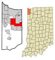
Coordinates: 41°29′8″N 87°20′7″W / 41.48556°N 87.33528°WCoordinates: 41°29′8″N 87°20′7″W / 41.48556°N 87.33528°W Country United States State Indiana County Lake Township Ross Government – Type Town – Town Administrator Howard Fink Area – Total 33.3 sq mi (86.3 km2) – Land 33.3 sq mi (86.2 km2) – Water 0.0 sq mi (0.1 km2) Elevation 656 ft (200 m) Population (2010) – Total 35,246 – Density 918.2/sq mi (354.5/km2) Time zone CST (UTC-6) – Summer (DST) CDT (UTC-5) ZIP codes 46410, 46411, 46342(Partial) Area code(s) 219 FIPS code 18-48528[1] GNIS feature ID 0439028[2] Website www.merrillville.in.gov Merrillville /ˈmɛrəlvɪl/ is a town in Ross Township, Lake County, Indiana, United States. The population was 35,246 at the 2010 census. Merrillville is located in the east-central portion of Lake County.
Contents
Geography
Merrillville is located at 41°29′08″N 87°20′07″W / 41.485669°N 87.335390°W.[3]
According to the United States Census Bureau, the town has a total area of 33.3 square miles (86 km2), of which, 33.3 square miles (86 km2) of it is land and 0.04 square miles (0.10 km2) of it (0.09%) is water.
The town is centered around the intersection of US 30 and Interstate 65. The Lincoln Highway runs through Merrillville. The original alignment of Lincoln Highway is known as 73rd Avenue (also called Old Lincoln Highway) in Merrillville, while the current Lincoln Highway (US Highway 30) is known as 81st Avenue. State Road 53 (Broadway) and State Road 55 (Taft Street) traverse the town from north to south.
Merrillville shares the most municipal boundaries out of any town in Lake County, Indiana. The town is bordered by Gary, Indiana & unincorporated Calumet, Indiana to the north, Hobart, Indiana to the northeast, Union Township, Porter County, Indiana to the east, Winfield, Indiana & Crown Point, Indiana to the south, Schererville, Indiana to the west, and Griffith, Indiana to the northwest.
History
Merrillville is located on what used to be woodland that belonged to the Potawatomi Indians. In 1834, a clearing was created for ceremonial purposes and was called McGwinn Village. A year later, a white man by the name of Jeremiah Wiggins settled in the place; McGwinn Village thus gave way to Wiggins Point.[4]
Under the name Wiggins Point, the place became a well-known stop for wagon trains heading to Joliet, Illinois along the old Sauk Trail (also called the Sac Trail), which was an old Indian trail. At one time, 16 trails radiated outward from Wiggins Point. In 1838, Wiggins died. Sometime afterwards, local settlers renamed the place Centerville. Later still, it was renamed Merrillville after the brothers Dudley and William Merrill.[4] Dudley Merrill operated a hotel and store in Centerville, and his son John P. Merrill was a Township Trustee.[5]
Nearby, in the same former hunting grounds of the Potawatomi Indians, other settlements had sprung up. Near Deep River creek was a settlement named Deep River; near Turkey Creek was another settlement with that creek's name. Other settlements included Ainsworth, Lottaville, and Rexville. At one time, the post office for the area was named Lottaville.
In 1848, all of these settlements, including Merrillville (that is, the old McGwinn Village) were collected into one and called Ross Township. As time went by, bits and pieces of Ross Township were taken by Hobart and Crown Point when those towns incorporated.
In 1971, the area officially became Merrillville (which now includes the old Merrillville as well as other settlements nearby) and was incorporated as a town under Indiana law.[4] During this time, the majority of the town's growth was due to white flight from Gary. At one time, Merrillville was known as the "largest town" in the U.S., with that distinction now going to Gilbert, Arizona.
In 1993, a large unincorporated area of Lake County along US 30, east of Mississippi St. and west of Indiana 51 was annexed by the neighboring city of Hobart. The residents of this area, although living in unincorporated Ross Township, associated themselves with Merrillville. This is because they were served by Merrillville schools and Post Office. As the area continues to be served by the Merrillville post office, local residents and businesses continue to identify themselves as being in Merrillville rather than Hobart.
Due to the unique shape of the annexed areas, someone traveling west on U.S. 30 will enter Lake County in Merrillville, then cross into Hobart, then cross into Merrillville again.
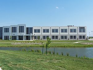 Purdue Technology Center at Ameriplex at the Crossroads in Merrillville
In 2009, a pedestrian bridge at Hidden Lake Park collapsed, injuring at least 25 people.[6] The catastrophe occurred around 10 PM after the annual Fourth of July fireworks display,[7] when several dozen people attempted to cross the wood suspension bridge.[8] Police officers stationed at either side of the bridge were unable to stop the advancing parkgoers, and with numerous people jumping up and down the 30 year old bridge collapsed, sending somewhere around fifty people into the waters of Hidden Lake.
In the census of 2010, the numbers illustrate that the vast majority of the growth in population was due to an increase in the African-American population. Most of this population moved from Gary and the South Side of Chicago. At the same time, the census showed a decrease in the white population, most of whom moved south to Crown Point and east into Porter County.
Economy
Merrillville is a hub for retail trade in Northwest Indiana. The US 30 corridor between Taft Street and Colorado Street harbors a large concentration of big-box retailers, hotels, restaurants, and automobile dealerships. Westfield Southlake, one of the largest shopping malls in Indiana, is located in this area.
Ameriplex at the Crossroads, an industrial and technology park, opened at Broadway between 93rd Avenue and 101st Avenue in 2005. The development is designated an Indiana Certified Technology Park and includes two Purdue University related facilities: Purdue University Calumet's Academic Learning Center and a business incubator/technology center operated by the Purdue Research Foundation.
Heavy industry such as steelmaking and petroleum refining that characterizes the economy of northern Lake County does not have a significant presence in Merrillville.
The town is home to the corporate headquarters of NiSource, a Fortune 500 company.
Merrillville's nearest commercial airports are Griffith-Merrillville Airport in Griffith and Gary/Chicago International Airport in Gary.
Merrillville is also protected by Indiana's largest volunteer fire department, the Ross Township Fire Service. It maintains over 120 all volunteer firefighters over four stations placed throughout the town.
Chicagoland's Largest Waterpark is located in Merrillville. Deep River Waterpark
Demographics
Historical populations Census Pop. %± 1980 27,677 — 1990 27,257 −1.5% 2000 30,560 12.1% Source: US Census Bureau As of the census[1] of 2000, there were 30,560 people, 11,678 households, and 8,127 families residing in the town. The population density was 918.2 people per square mile (354.5/km²). There were 12,303 housing units at an average density of 369.6/sq mi (142.7/km²). The racial makeup of the town was 69.65% White, 22.86% African American, 0.33% Native American, 1.51% Asian, 0.02% Pacific Islander, 3.39% from other races, and 2.24% from two or more races. Hispanic or Latino of any race were 9.65% of the population.
There were 11,678 households out of which 32.2% had children under the age of 18 living with them, 52.9% were married couples living together, 12.6% had a female householder with no husband present, and 30.4% were non-families. 26.1% of all households were made up of individuals and 11.8% had someone living alone who was 65 years of age or older. The average household size was 2.57 and the average family size was 3.12.
In the town the population was spread out with 24.6% under the age of 18, 8.7% from 18 to 24, 29.4% from 25 to 44, 22.2% from 45 to 64, and 15.1% who were 65 years of age or older. The median age was 37 years. For every 100 females there were 91.2 males. For every 100 females age 18 and over, there were 86.7 males.
The median income for a household in the town was $49,545, and the median income for a family was $56,355. Males had a median income of $41,820 versus $29,005 for females. The per capita income for the town was $22,293. About 2.6% of families and 4.3% of the population were below the poverty line, including 4.1% of those under age 18 and 5.5% of those age 65 or over.
Transportation
Gary Public Transportation Corporation provides bus service along Broadway Avenue corridor and within the US 30 retail/office corridor. Those routes are partially funded by Northwest Indiana Regional Bus Authority. The closest South Shore Line station is located in downtown Gary and can be reached using GPTC Route 17. The closest Amtrak station is located in Dyer, Indiana. It cannot be directly reached by public transit as of this writing.
Education
Public education in the town of Merrillville is provided by the Merrillville Community School Corporation.
Lake County Public Library operates the Central Library at 1919 West 81st Avenue in Merrillville.[9]
References
- ^ a b "American FactFinder". United States Census Bureau. http://factfinder.census.gov. Retrieved 2008-01-31.
- ^ "US Board on Geographic Names". United States Geological Survey. 2007-10-25. http://geonames.usgs.gov. Retrieved 2008-01-31.
- ^ "US Gazetteer files: 2010, 2000, and 1990". United States Census Bureau. 2011-02-12. http://www.census.gov/geo/www/gazetteer/gazette.html. Retrieved 2011-04-23.
- ^ a b c http://www.townofmerrillville.com/town_history.html Archived September 23, 2006 at the Wayback Machine
- ^ http://www.lowellpl.lib.in.us/merrill.htm
- ^ http://www.indystar.com/article/20090705/LOCAL/90705001/16+hurt+after+Merrillville+bridge+collapses[dead link]
- ^ http://www.nwi.com/articles/2009/07/05/news/top/doc4a5048a73c7bc222958411[dead link]
- ^ Official: Bridge at Hidden Lake was overcrowded
- ^ "Locations and Hours." Lake County Public Library. Retrieved on January 21, 2009.[dead link]
External links
- Town of Merrillville, Indiana website
- Merrillville Chamber of Commerce
- Merrillville Alumni Web Site - home for alumni of Merrillville High School
- Andrean High School
Municipalities and communities of Lake County, Indiana Cities Crown Point | East Chicago | Gary | Hammond | Hobart | Lake Station | Whiting

Towns Cedar Lake | Dyer | Griffith | Highland | Lowell | Merrillville | Munster | New Chicago | St. John | Schererville | Schneider | Winfield
Townships Calumet | Cedar Creek | Center | Eagle Creek | Hanover | Hobart | North | Ross | St. John | West Creek | Winfield
Unincorporated
communitiesAinsworth | Belshaw | Brunswick | Creston | Deep River | Deer Creek | Dinwiddie | Green Acres | Hawthorne Hills | Klaasville | Kreitzburg | Lake Dalecarlia | Lake Hills | Lakes of the Four Seasons‡ | Leroy | Liberty Park | Liverpool | New Elliott | North Hayden | Orchard Grove | Palmer | Range Line | Rolling Hill Estates | Ross | Shady Lawn | Shelby | Southeast Grove | Southmoor Park | Van Loon | Wald View | Woodmar
Footnotes ‡This populated place also has portions in an adjacent county or counties
 State of Indiana
Topics - Index
- Demographics
- Economy
- Geography
- Government
- Governor (List)
- Congressional districts (Delegations)
- History
- Hoosiers
- City Nicknames
- National Historic Landmarks
- Sports
- State parks
- Symbols
- Transportation
- Visitor Attractions
- Index of Indiana-related articles
- Outline
Regions - Central Indiana
- East Central Indiana
- Illinois-Indiana-Kentucky Tri-State Area
- Indiana-Kentucky-Ohio Tri-State Area
- Michiana
- Northern Indiana
- Northwest Indiana
- Southern Indiana
- Southwestern Indiana
- Wabash Valley
Largest cities - Indianapolis
- Fort Wayne
- Evansville
- South Bend
- Hammond
- Bloomington
- Gary
- Carmel
- Lafayette
- Muncie
- Anderson
- Terre Haute
- Elkhart
- Kokomo
- Mishawaka
- Richmond
- Columbus
- Lawrence
- Jeffersonville
- Greenwood
- New Albany
- Portage
- Michigan City
- East Chicago
- Goshen
- Marion
- Valparaiso
- Noblesville
- West Lafayette
- Hobart
- Crown Point
- Franklin
- La Porte
- Seymour
- Logansport
- New Castle
- Connersville
- Vincennes
- Bedford
- Jasper
- Washington
- Princeton
- Westfield
Largest towns - Fishers
- Merrillville
- Schererville
- Clarksville
- Plainfield
- Highland
- Munster
Counties - Adams
- Allen
- Bartholomew
- Benton
- Blackford
- Boone
- Brown
- Carroll
- Cass
- Clark
- Clay
- Clinton
- Crawford
- Daviess
- Dearborn
- Decatur
- DeKalb
- Delaware
- Dubois
- Elkhart
- Fayette
- Floyd
- Fountain
- Franklin
- Fulton
- Gibson
- Grant
- Greene
- Hamilton
- Hancock
- Harrison
- Hendricks
- Henry
- Howard
- Huntington
- Jackson
- Jasper
- Jay
- Jefferson
- Jennings
- Johnson
- Knox
- Kosciusko
- LaGrange
- Lake
- LaPorte
- Lawrence
- Madison
- Marion
- Marshall
- Martin
- Miami
- Monroe
- Montgomery
- Morgan
- Newton
- Noble
- Ohio
- Orange
- Owen
- Parke
- Perry
- Pike
- Porter
- Posey
- Pulaski
- Putnam
- Randolph
- Ripley
- Rush
- Saint Joseph
- Scott
- Shelby
- Spencer
- Starke
- Steuben
- Sullivan
- Switzerland
- Tippecanoe
- Tipton
- Union
- Vanderburgh
- Vermillion
- Vigo
- Wabash
- Warren
- Warrick
- Washington
- Wayne
- Wells
- White
- Whitley
Categories:- Populated places in Lake County, Indiana
- Towns in Indiana
- Northwest Indiana
- Chicago metropolitan area
- Populated places established in 1834
- Merrillville, Indiana


Wikimedia Foundation. 2010.