- Bartholomew County, Indiana
-
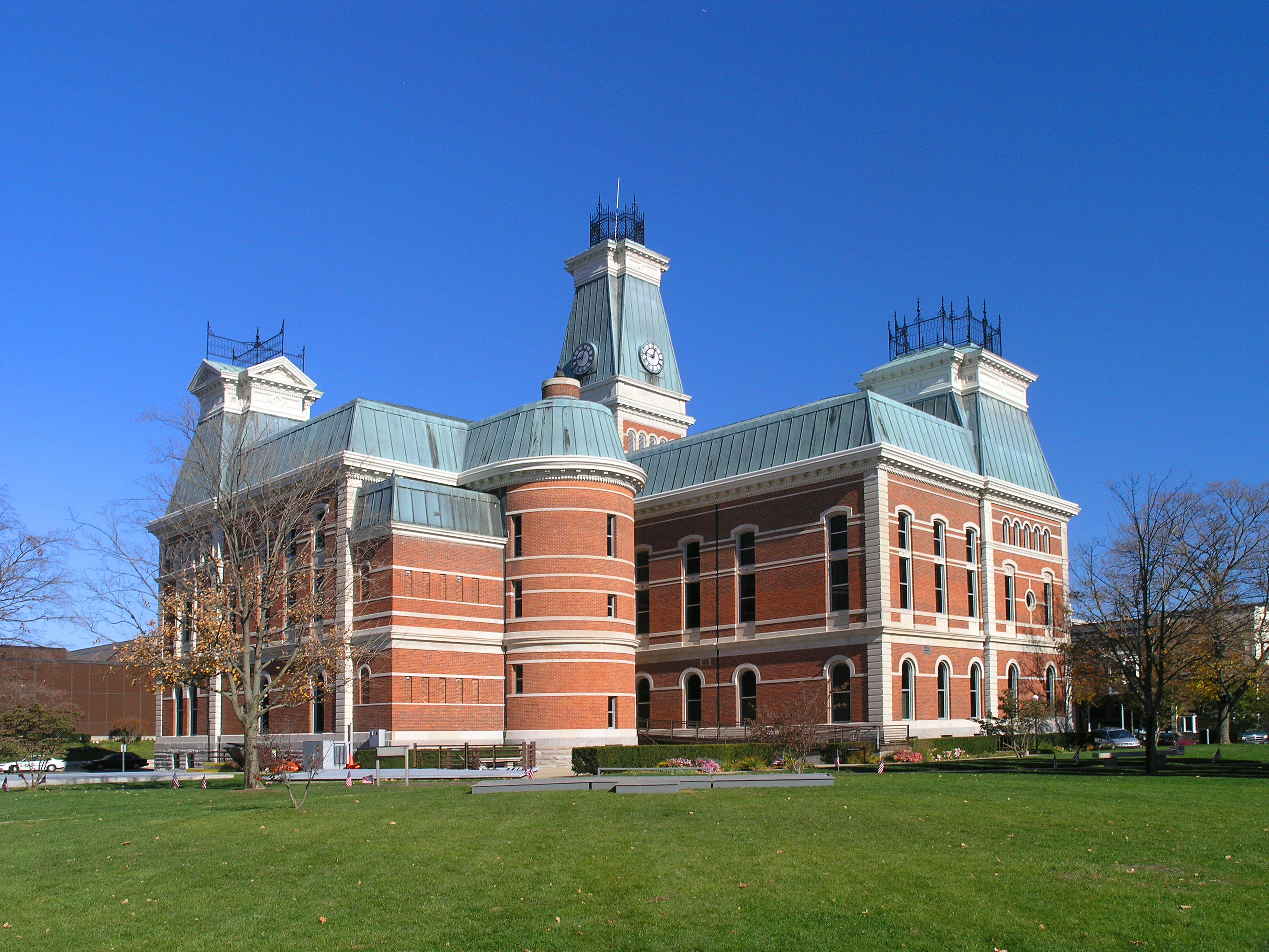
Bartholomew County, Indiana 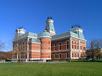 Bartholomew County courthouse in Colombus, Indiana
Seal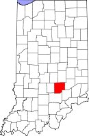
Location in the state of Indiana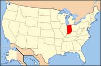
Indiana's location in the U.S.Founded 12 February 1821 Seat Columbus Area
- Total
- Land
- Water
409.52 sq mi (1,061 km²)
406.91 sq mi (1,054 km²)
2.62 sq mi (7 km²), 0.64%Population
- (2010)
- Density
76,794
189/sq mi (72.88/km²)Congressional districts 6th, 9th Website www.bartholomewco.com Footnotes: Indiana county number 3
Bartholomew County is a county located in the U.S. state of Indiana, and determined by the U.S. Census Bureau to include the mean center of U.S. population in 1900.[1] As of 2010, the population was 76,794.[2] The county seat is Columbus. It is part of the Columbus metropolitan statistical area which encompasses all of Bartholomew County.
Contents
History
Bartholomew County was formed February 12, 1821 and was named for Lt. Col. Joseph Bartholomew, wounded at the Battle of Tippecanoe.[3] The site of the county seat was chosen on February 15, 1821 by a team of commissioners, who suggested the name Tiptona, in honor of John Tipton; on March 20, the name Columbus was adopted.
Courthouse
The current Bartholomew County courthouse was built from 1870 to 1874 by McCormack and Sweeney of Columbus at a cost of $225,000.
It was designed by architect Isaac Hodgson, who was born in Belfast, Ireland in 1826 and immigrated to the United States in 1848; he designed six Indiana courthouses, including the one in Henry County.
The courthouse is built largely of brick and has mansard roofs typical of the Second Empire French style. Its asymmetrical "L" shape allows it to face two major streets in Columbus. The inscription indicating the commissioners, architect and date is high up on the east facade.[4]
Today the Bartholomew County Veterans Memorial designed by American architect Charles Rose sits adjacent to the Courthouse.
Geography
 Map of Bartholomew County
According to the 2010 census, the county has a total area of 409.52 square miles (1,060.7 km2), of which 406.91 square miles (1,053.9 km2) (or 99.36%) is land and 2.62 square miles (6.8 km2) (or 0.64%) is water.[5] Camp Atterbury occupies the northwestern corner of the county.
Adjacent counties
- Shelby County (northeast)
- Decatur County (east)
- Jennings County (southeast)
- Jackson County (south)
- Brown County (west)
- Johnson County (northwest)
Cities and towns
Unincorporated towns
Extinct towns
- Kansas
- South Bethany
Townships
Major highways
 Interstate 65
 U.S. Route 31
 Indiana State Road 7
 Indiana State Road 9
 Indiana State Road 11
 Indiana State Road 46
 Indiana State Road 58
Railroads
Climate and weather
Columbus, Indiana Climate chart (explanation) J F M A M J J A S O N D 2.737192.642223.753314.464414.674523.58361486653.885633.179552.867423.854343.24225Average max. and min. temperatures in °F Precipitation totals in inches Source: The Weather Channel[6] Metric conversion J F M A M J J A S O N D 683-7676-69312-1111185118231188281610230189529177826137119696121806-4Average max. and min. temperatures in °C Precipitation totals in mm In recent years, average temperatures in Columbus have ranged from a low of 19 °F (−7 °C) in January to a high of 86 °F (30 °C) in July, although a record low of −27 °F (−33 °C) was recorded in January 1912 and a record high of 111 °F (44 °C) was recorded in July 1934. Average monthly precipitation ranged from 2.63 inches (67 mm) in February to 4.63 inches (118 mm) in May.[6]
Government
See also: Government of IndianaThe county government is a constitutional body, and is granted specific powers by the Constitution of Indiana, and by the Indiana Code.
County Council: The county council is the legislative branch of the county government and controls all the spending and revenue collection in the county. Representatives are elected from county districts. The council members serve four year terms. They are responsible for setting salaries, the annual budget, and special spending. The council also has limited authority to impose local taxes, in the form of an income and property tax that is subject to state level approval, excise taxes, and service taxes.[7][8]
Board of Commissioners: The executive body of the county is made of a board of commissioners. The commissioners are elected county-wide, in staggered terms, and each serves a four-year term. One of the commissioners, typically the most senior, serves as president. The commissioners are charged with executing the acts legislated by the council, collecting revenue, and managing the day-to-day functions of the county government.[7][8]
Court: The county maintains a small claims court that can handle some civil cases. The judge on the court is elected to a term of four years and must be a member of the Indiana Bar Association. The judge is assisted by a constable who is also elected to a four-year term. In some cases, court decisions can be appealed to the state level circuit court.[8]
County Officials: The county has several other elected offices, including sheriff, coroner, auditor, treasurer, recorder, surveyor, and circuit court clerk. Each of these elected officers serves a term of four years and oversees a different part of county government. Members elected to county government positions are required to declare a party affiliation and to be residents of the county.[8]
Bartholomew County is part of Indiana's 6th congressional district and Indiana's 9th congressional district; Indiana Senate district 41;[9] and Indiana House of Representatives districts 57, 59 and 65.[10]
Demographics
Historical populations Census Pop. %± 1830 5,476 — 1840 10,042 83.4% 1850 12,428 23.8% 1860 17,865 43.7% 1870 21,133 18.3% 1880 22,777 7.8% 1890 23,867 4.8% 1900 24,594 3.0% 1910 24,813 0.9% 1920 23,887 −3.7% 1930 24,864 4.1% 1940 28,276 13.7% 1950 36,108 27.7% 1960 48,198 33.5% 1970 57,022 18.3% 1980 65,088 14.1% 1990 63,657 −2.2% 2000 71,435 12.2% 2010 76,794 7.5% Sources: United States Department of Commerce,
Bureau of the Census, Population Division[11]
Census Quickfacts[2]As of the census[12] of 2000, there were 71,435 people, 27,936 households, and 20,058 families residing in the county. The population density was 176 people per square mile (68/km²). There were 29,853 housing units at an average density of 73 per square mile (28/km²). The racial makeup of the county was 94.17% White, 1.83% Black or African American, 0.15% Native American, 1.9% Asian, 0.04% Pacific Islander, 0.96% from other races, and 0.95% from two or more races. 2.24% of the population were Hispanic or Latino of any race. 25.4% were of German, 25.2% American, 11.7% English and 9.1% Irish ancestry according to Census 2000.
There were 27,936 households out of which 33.9% had children under the age of 18 living with them, 58.6% were married couples living together, 9.7% had a female householder with no husband present, and 28.2% were non-families. 24.0% of all households were made up of individuals and 8.8% had someone living alone who was 65 years of age or older. The average household size was 2.52 and the average family size was 2.98.
In the county the population was spread out with 26.5% under the age of 18, 7.7% from 18 to 24, 29.70% from 25 to 44, 24.0% from 45 to 64, and 12.1% who were 65 years of age or older. The median age was 36 years. For every 100 females there were 96.6 males. For every 100 females age 18 and over, there were 93.9 males.
The median income for a household in the county was $44,184, and the median income for a family was $52,097. Males had a median income of $38,350 versus $24,652 for females. The per capita income for the county was $21,536. About 5.9% of families and 7.3% of the population were below the poverty line, including 9.20% of those under age 18 and 7.9% of those age 65 or over.
Education
Public schools in Bartholomew County are administered by the Bartholomew Consolidated School Corporation and the Flat Rock-Hawcreek School Corporation. The county's first tuition-free public charter school, the International School of Columbus, a middle school/high school, opened in 2009-10. The ISC is an International Baccalaureate World School offering the Diploma Program.
See also
References
- ^ "Mean Center of Population for the United States: 1790 to 2000". United States Census Bureau. http://www.census.gov/geo/www/cenpop/meanctr.pdf. Retrieved 2011-09-17.
- ^ a b "Bartholomew County QuickFacts". United States Census Bureau. http://quickfacts.census.gov/qfd/states/18/18005.html. Retrieved 2011-09-17.
- ^ Baker, Ronald L.; Carmony, Marvin (1975). Indiana Place Names. Bloomington, Indiana: Indiana University Press. p. 9.
- ^ Counts, Will; Jon Dilts (1991). The 92 Magnificent Indiana Courthouses. Bloomington, Indiana: Indiana University Press. pp. 12–13. ISBN 978-0253336385.
- ^ "Census 2010 U.S. Gazetteer Files: Counties". United States Census. http://www.census.gov/geo/www/gazetteer/files/Gaz_counties_national.txt. Retrieved 2011-10-10.
- ^ a b "Monthly Averages for Columbus, Indiana". The Weather Channel. http://www.weather.com/weather/wxclimatology/monthly/graph/USIN0126. Retrieved 2011-01-27.
- ^ a b Indiana Code. "Title 36, Article 2, Section 3". IN.gov. http://www.in.gov/legislative/ic/code/title36/ar2/ch3.html. Retrieved 2008-09-16.
- ^ a b c d Indiana Code. "Title 2, Article 10, Section 2". IN.gov. http://www.in.gov/legislative/ic/code/title3/ar10/ch2.pdf. Retrieved 2008-09-16.
- ^ "Indiana Senate Districts". State of Indiana. http://www.in.gov/sos/elections/3006.htm. Retrieved 2011-01-23.
- ^ "Indiana House Districts". State of Indiana. http://www.in.gov/sos/elections/3005.htm. Retrieved 2011-01-23.
- ^ Forstall, Richard L. (editor) (1996). Population of states and counties of the United States: 1790 to 1990 : from the twenty-one decennial censuses. United States Department of Commerce, Bureau of the Census, Population Division. pp. 50–53. ISBN 0-934213-48-8. http://books.google.com/books?id=Z12v1lrkv2IC&lpg=PA50&pg=PA50#v=onepage&q&f=false.
- ^ "American FactFinder". United States Census Bureau. http://factfinder.census.gov. Retrieved 2008-01-31.
External links
- Bartholomew County official website
- Bartholomew Consolidated School Corporation
- Flat Rock-Hawcreek School Corporation
- International School of Columbus

Johnson County Shelby County Brown County 
Decatur County  Bartholomew County, Indiana

Jackson County Jennings County Municipalities and communities of Bartholomew County, Indiana County seat: Columbus City 
Towns Clifford | Edinburgh‡ | Elizabethtown | Hartsville | Hope | Jonesville
Townships Unincorporated
communitiesAzalia | Bethel Village | Burnsville | Corn Brook | Everroad Park | Flat Rock Park | Garden City | Grammer | Grandview Lake | Jewell Village | Lowell | Mount Healthy | Newbern | North Gate | North Ogilville | North Park | Northcliff | Nortonburg | Ogilville | Old Saint Louis | Petersville | Pleasant View Village | Riverview Acres | Rosstown | Rugby | Saint Louis Crossing | Stony Lonesome | Taylorsville | Twin Crest | Walesboro | Waymansville | Waynesville
Footnotes ‡This populated place also has portions in an adjacent county or counties
Categories:- Indiana counties
- Bartholomew County, Indiana
- 1821 establishments in the United States
- Populated places established in 1821


Wikimedia Foundation. 2010.