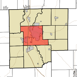
- Columbus Township, Bartholomew County, Indiana
-
Columbus Township — Township — Location in Bartholomew County Coordinates: 39°12′42″N 85°56′06″W / 39.21167°N 85.935°WCoordinates: 39°12′42″N 85°56′06″W / 39.21167°N 85.935°W Country United States State Indiana County Bartholomew Government - Type Indiana township Area - Total 55.55 sq mi (143.88 km2) - Land 54.89 sq mi (142.17 km2) - Water 0.66 sq mi (1.72 km2) 1.2% Elevation 617 ft (188 m) Population (2000) - Total 41,194 - Density 750.5/sq mi (289.8/km2) ZIP codes 47201, 47203 GNIS feature ID 0453243 Columbus Township is one of twelve townships in Bartholomew County, Indiana, USA. As of the 2000 census, its population was 41,194.[1]
Contents
Geography
According to the United States Census Bureau, Columbus Township covers an area of 55.55 square miles (143.9 km2); of this, 0.66 square miles (1.7 km2) or 1.2 percent is water. Camp Atterbury borders the township to the northwest.
Cities, towns, villages
- Columbus (south three-quarters)
Unincorporated towns
- Corn Brook
- East Columbus
- Everroad Park
- Flat Rock Park
- Forest Park
- Garden City
- Lowell
- North Columbus
- Parkside
- Riverview Acres
(This list is based on USGS data and may include former settlements.)
Adjacent townships
- German Township (north)
- Flat Rock Township (northeast)
- Clay Township (east)
- Rock Creek Township (east)
- Sand Creek Township (southeast)
- Wayne Township (south)
- Ohio Township (southwest)
- Harrison Township (west)
Cemeteries
The township contains these five cemeteries: Carter, Garland Brook, Lambert, Mount Pleasant and Thompson.
Major highways
 Interstate 65
 U.S. Route 31
 Indiana State Road 7
 Indiana State Road 9
 Indiana State Road 11
 Indiana State Road 46
Airports and landing strips
- Bartholomew County Hospital Airport
Rivers
Lakes
- Crystal Lake
- Long Lake
- Terrace Lake
- Wood Lake
Landmarks
- Clifty Creek Park
- Donner Park
- Lincoln Park
- Noblitt Park
School districts
- Bartholomew County School Corporation
Political districts
- Indiana's 6th congressional district
- State House District 57
- State House District 59
- State House District 65
- State Senate District 41
References
- United States Census Bureau 2007 TIGER/Line Shapefiles
- United States Board on Geographic Names (GNIS)
- United States National Atlas
External links
Municipalities and communities of Bartholomew County, Indiana City Towns Clifford | Edinburgh‡ | Elizabethtown | Hartsville | Hope | Jonesville
Townships Unincorporated
communitiesAzalia | Bethel Village | Burnsville | Corn Brook | Everroad Park | Flat Rock Park | Garden City | Grammer | Grandview Lake | Jewell Village | Lowell | Mount Healthy | Newbern | North Gate | North Ogilville | North Park | Northcliff | Nortonburg | Ogilville | Old Saint Louis | Petersville | Pleasant View Village | Riverview Acres | Rosstown | Rugby | Saint Louis Crossing | Stony Lonesome | Taylorsville | Twin Crest | Walesboro | Waymansville | Waynesville
Footnotes ‡This populated place also has portions in an adjacent county or counties
Categories:- Townships in Bartholomew County, Indiana
Wikimedia Foundation. 2010.

