- Miami County, Indiana
-
Miami County, Indiana 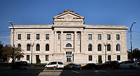 Miami County courthouse in Peru, Indiana
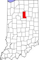
Location in the state of Indiana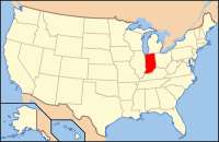
Indiana's location in the U.S.Founded 1834 Named for Miami tribe Seat Peru Largest City Peru Area
- Total
- Land
- Water
377.39 sq mi (977 km²)
373.84 sq mi (968 km²)
3.55 sq mi (9 km²), 0.94%Population
- (2010)
- Density
36,903
98/sq mi (37.93/km²)Congressional district 5th Time zone Eastern: UTC-5/-4 Website www.MiamiCountyIN.gov Footnotes: Indiana county number 52
Miami County is a county located in the U.S. state of Indiana. As of 2010, the population was 36,903.[1] The county seat is Peru[2].
Contents
History
Miami County was formed in 1834. It was named for the Miami, a Native American people, many of whom still live in this area.[3]
Geography
According to the 2010 census, the county has a total area of 377.39 square miles (977.4 km2), of which 373.84 square miles (968.2 km2) (or 99.06%) is land and 3.55 square miles (9.2 km2) (or 0.94%) is water.[4]
Adjacent counties
- Fulton County (north)
- Wabash County (east)
- Grant County (southeast)
- Howard County (south)
- Cass County (west)
Major highways
 U.S. Route 24
 U.S. Route 31
 Indiana State Road 16
 Indiana State Road 18
 Indiana State Road 19
 Indiana State Road 124
 Indiana State Road 218
Cities and towns
Incorporated
Unincorporated
- Bennetts Switch
- Birmingham
- Chili
- Courter
- Deedsville
- Erie Township, Miami County, Indiana
- Flora
- Gilead
- Loree
- McGrawsville
- Miami
- New Santa Fe
- North Grove
- Peoria
- Perrysburg
- Pettysville
- Santa Fe
- South Peru
- Stockdale
- Wawpecong
- Wells
Extinct
- Doyle
- Leonda
- Paw Paw
- Wagoners Station
Townships
- Allen Township
- Butler Township
- Clay Township
- Deer Creek Township
- Erie Township
- Harrison Township
- Jackson Township
- Jefferson Township
- Perry Township
- Peru Township
- Pipe Creek Township
- Richland Township
- Union Township
- Washington Township
Climate and weather
Peru, Indiana Climate chart (explanation) J F M A M J J A S O N D 2.231141.936172.747273.560374.171484.280584.18361481593.275512.863403.149312.73620Average max. and min. temperatures in °F Precipitation totals in inches Source: The Weather Channel[5] Metric conversion J F M A M J J A S O N D 55-1-10482-8698-39016310322910727141052816102271581241171174799-1692-7Average max. and min. temperatures in °C Precipitation totals in mm In recent years, average temperatures in Peru have ranged from a low of 14 °F (−10 °C) in January to a high of 83 °F (28 °C) in July, although a record low of −24 °F (−31 °C) was recorded in January 1985 and a record high of 103 °F (39 °C) was recorded in June 1988. Average monthly precipitation ranged from 1.89 inches (48 mm) in February to 4.23 inches (107 mm) in June.[5]
Government
The county government is a constitutional body, and is granted specific powers by the Constitution of Indiana, and by the Indiana Code.
County Council: The county council is the legislative branch of the county government and controls all the spending and revenue collection in the county. Representatives are elected from county districts. The council members serve four year terms. They are responsible for setting salaries, the annual budget, and special spending. The council also has limited authority to impose local taxes, in the form of an income and property tax that is subject to state level approval, excise taxes, and service taxes.[6][7]
Board of Commissioners: The executive body of the county is made of a board of commissioners. The commissioners are elected county-wide, in staggered terms, and each serves a four-year term. One of the commissioners, typically the most senior, serves as president. The commissioners are charged with executing the acts legislated by the council, collecting revenue, and managing the day-to-day functions of the county government.[6][7]
Court: The county maintains a small claims court that can handle some civil cases. The judge on the court is elected to a term of four years and must be a member of the Indiana Bar Association. The judge is assisted by a constable who is also elected to a four-year term. In some cases, court decisions can be appealed to the state level circuit court.[7]
County Officials: The county has several other elected offices, including sheriff, coroner, auditor, treasurer, recorder, surveyor, and circuit court clerk Each of these elected officers serves a term of four years and oversees a different part of county government. Members elected to county government positions are required to declare party affiliations and to be residents of the county.[7]
Miami County is part of Indiana's 5th congressional district; Indiana Senate district 18;[8] and Indiana House of Representatives districts 23, 24 and 32.[9]
Demographics
Historical populations Census Pop. %± 1840 3,048 — 1850 11,304 270.9% 1860 16,851 49.1% 1870 21,052 24.9% 1880 24,083 14.4% 1890 25,823 7.2% 1900 28,344 9.8% 1910 29,350 3.5% 1920 28,668 −2.3% 1930 29,032 1.3% 1940 27,926 −3.8% 1950 28,201 1.0% 1960 38,000 34.7% 1970 39,246 3.3% 1980 39,820 1.5% 1990 36,897 −7.3% 2000 36,082 −2.2% 2010 36,903 2.3% Sources: United States Department of Commerce,
Bureau of the Census, Population Division[10]
Census Quickfacts[1]As of the census[11] of 2000, there were 36,082 people, 13,716 households, and 9,806 families residing in the county. The population density was 96 people per square mile (37/km²). There were 15,299 housing units at an average density of 41 per square mile (16/km²). The racial makeup of the county was 93.69% White, 3.00% Black or African American, 1.08% Native American, 0.33% Asian, 0.02% Pacific Islander, 0.46% from other races, and 1.42% from two or more races. 1.32% of the population were Hispanic or Latino of any race. 25.8% were of German, 25.6% American, 9.8% Irish and 9.1% English ancestry according to Census 2000.
There were 13,716 households out of which 33.70% had children under the age of 18 living with them, 57.80% were married couples living together, 9.80% had a female householder with no husband present, and 28.50% were non-families. 24.60% of all households were made up of individuals and 10.10% had someone living alone who was 65 years of age or older. The average household size was 2.52 and the average family size was 3.00.
In the county the population was spread out with 25.90% under the age of 18, 8.10% from 18 to 24, 29.90% from 25 to 44, 23.30% from 45 to 64, and 12.90% who were 65 years of age or older. The median age was 37 years. For every 100 females there were 103.10 males. For every 100 females age 18 and over, there were 102.00 males.
The median income for a household in the county was $39,184, and the median income for a family was $45,816. Males had a median income of $34,595 versus $21,311 for females. The per capita income for the county was $17,726. About 6.00% of families and 8.00% of the population were below the poverty line, including 10.90% of those under age 18 and 5.40% of those age 65 or over.
See also
References
- ^ a b "Miami County QuickFacts". United States Census Bureau. http://quickfacts.census.gov/qfd/states/18/18103.html. Retrieved 2011-09-25.
- ^ "Find a County". National Association of Counties. http://www.naco.org/Counties/Pages/FindACounty.aspx. Retrieved 2011-06-07.
- ^ De Witt Clinton Goodrich & Charles Richard Tuttle (1875). An Illustrated History of the State of Indiana. Indiana: R. S. Peale & co.. pp. 578. http://books.google.com/books?id=YDIUAAAAYAAJ.
- ^ "Census 2010 U.S. Gazetteer Files: Counties". United States Census. http://www.census.gov/geo/www/gazetteer/files/Gaz_counties_national.txt. Retrieved 2011-10-10.
- ^ a b "Monthly Averages for Peru, Indiana". The Weather Channel. http://www.weather.com/weather/wxclimatology/monthly/graph/USIN0528. Retrieved 2011-01-27.
- ^ a b Indiana Code. "Title 36, Article 2, Section 3". IN.gov. http://www.in.gov/legislative/ic/code/title36/ar2/ch3.html. Retrieved 2008-09-16.
- ^ a b c d Indiana Code. "Title 2, Article 10, Section 2". IN.gov. http://www.in.gov/legislative/ic/code/title3/ar10/ch2.pdf. Retrieved 2008-09-16.
- ^ "Indiana Senate Districts". State of Indiana. http://www.in.gov/sos/elections/3006.htm. Retrieved 2011-07-14.
- ^ "Indiana House Districts". State of Indiana. http://www.in.gov/sos/elections/3005.htm. Retrieved 2011-07-14.
- ^ Forstall, Richard L. (editor) (1996). Population of states and counties of the United States: 1790 to 1990 : from the twenty-one decennial censuses. United States Department of Commerce, Bureau of the Census, Population Division. pp. 50–53. ISBN 0-934213-48-8. http://books.google.com/books?id=Z12v1lrkv2IC&lpg=PA50&pg=PA50#v=onepage&q&f=false.
- ^ "American FactFinder". United States Census Bureau. http://factfinder.census.gov. Retrieved 2008-01-31.

Fulton County Cass County 
Wabash County  Miami County, Indiana

Howard County Grant County Municipalities and communities of Miami County, Indiana City 
Towns Amboy | Bunker Hill | Converse‡ | Denver | Macy
Townships Allen | Butler | Clay | Deer Creek | Erie | Harrison | Jackson | Jefferson | Perry | Peru | Pipe Creek | Richland | Union | Washington
Unincorporated
communitiesBirmingham | Chili | Courter | Deedsville | Doyle | Erie | Flora | Gilead | Grissom JARB‡ | Loree | McGrawsville | Mexico | Miami | Nead | New Santa Fe | North Grove | Park View Heights | Peoria | Perrysburg | Pettysville | Santa Fe | South Peru | Wawpecong | Wells
Footnotes ‡This populated place also has portions in an adjacent county or counties
Categories:- Indiana counties
- Miami County, Indiana
- 1834 establishments in the United States
- Populated places established in 1834


Wikimedia Foundation. 2010.