- Indiana State Road 18
Infobox road
state=IN
type=IN
route=18
alternate_name=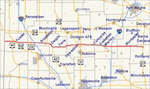
length_mi=141.1
length_round=1
length_ref= [http://illi-indi.com/EndsPage.php?id=1018§ion=1 Indiana Highway Ends - SR 18] ]
established=
direction_a=West
starting_terminus=Illinois state line west of Fowler
junction=
direction_b=East
ending_terminus=
counties=Benton, White, Carroll, Cass, Miami, Grant, Blackford, Jay
previous_type=IN
previous_route=17
next_type=IN
next_route=19State Road 18 in the
U.S. State ofIndiana is an east-west route in North Central Indiana running from theIllinois border in Benton County almost to theOhio border, terminating at US 27 in Jay County. State Road 18 passes through the following towns and cities, from west to east:* Fowler (intersects US 52)
* Brookston (intersects Indiana 43)
* Delphi (concurrent with US 421, Indiana 39 for a few miles on each side of the town, all three concurrent with Indiana 25 through downtown)
* Flora
* Young America
* Galveston (intersects US 35)
* Bennett's Switch
* Wawpecong
* Converse
* Sweetser
* Marion (intersectsInterstate 69 Exit 64)
* MontpelierState Route 18 is mainly a 2 lane road with exception of 4 lane divided highway from Marion to I-69. Marion is the only considerably large city that Route 18 passes through. State Route 18 runs just south of the lakes region, with Lake Shafer, Lake Freeman, Mississinewa Reservoir, and Salamonie Reservoir not too far to the north. Along State Route 18, you will see small farming towns and lots of flat ground.
Major intersections
Source: INDOT Roadway Referencing System [cite web|url=http://www.in.gov/indot/3361.htm|title=INDOT Roadway Referencing System] INint
county=Benton
cspan=4
mile=0.00
location=Benton County
lspan=2
notes=SR 18 begins at the Illinois borderINint
mile=1.94
road=INint
mile=10.93
road=
type=concur
notes=concurrency begins
location=Fowler
lspan=2INint
mile=12.15
road=
type=concur
notes=concurrency ends after 1.22 milesINint
county=White
cspan=4
mile=26.65
road=
notes=overpass
location=White County
lspan=2INint
mile=29.36
road=
notes=overpassINint
mile=35.16
road=
type=concur
notes=concurrency begins
location=Brookston
lspan=2INint
mile=35.34
road=
type=concur
notes=concurrency ends after 0.18 milesINint
county=Carroll
cspan=5
mile=42.66
road=
type=concur
notes=concurrency begins
location=Carroll County
lspan=2INint
mile=48.97
road=
type=concur
notes=concurrency ends after 6.31 milesINint
mile=54.99
road=
location=FloraINint
mile=62.23
road=
type=concur
notes=concurrency begins
location=Carroll County
lspan=2INint
mile=63.74
road=
type=concur
notes=concurrency ends after 1.51 milesINint
county=Cass
cspan=1
mile=74.76
road=
location=GalvestonINint
county=Miami
cspan=2
mile=78.24
road=
location=Miami County
lspan=2INint
mile=89.16
road=INint
county=Grant
cspan=4
mile=94.71
road=
type=concur
notes=concurrency begins
location=Converse
lspan=2INint
mile=95.02
road=
type=concur
notes=concurrency ends after 0.31 milesINint
mile=109.84
road=
notes=underpass
location=MarionINint
mile=112.32
road=
location=Grant CountyINint
county=Blackford
mile=119.33
road=
location=Blackford CountyINint
county=Jay
cspan=2
mile=131.06
road=
location=MontpelierINint
mile=141.13
road=
location=Bryant
notes=SR 18 endsReferences

Wikimedia Foundation. 2010.