- Montpelier, Indiana
-
Montpelier, Indiana — City — Montpelier, Indiana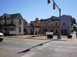
Nickname(s): Oil City Location in the state of Indiana
Coordinates: 40°33′11″N 85°16′53″W / 40.55306°N 85.28139°WCoordinates: 40°33′11″N 85°16′53″W / 40.55306°N 85.28139°W Country United States State Indiana County Blackford Settled 1836 Incorporated (town) 1870 Incorporated (city) 1895 Government – Mayor James A. McPherson (D) Area – Total 1.1 sq mi (2.8 km2) – Land 1.1 sq mi (2.8 km2) – Water 0 sq mi (0 km2) 0% Elevation 869 ft (265 m) Population (2010) – Total 1,805 – Density 1,757.9/sq mi (677.1/km2) Time zone EST (UTC-5) – Summer (DST) EDT (UTC-4) ZIP code 47359 Area code(s) 765 FIPS code 18-50796[1] GNIS feature ID 0439371[2] Website http://montpelier-indiana.com/ Montpelier /mɒntˈpiːliər/ is an American city in Blackford County, Indiana. This small rural community, the county’s first to be platted, was established by settlers from Vermont, and is named after Vermont’s capital city – Montpelier.
Montpelier was a central participant in the Indiana Gas Boom, as natural gas was discovered near the community in 1887. More importantly, the county’s first successful oil well was drilled on the south side of Montpelier in 1890. The town’s population quickly grew from 808 in 1890 to about 6,500 by 1896. The Gas Boom, mostly an oil boom for Montpelier, gradually ended during the first decade of the 20th century.
Like many boom towns, the city’s population has never matched that of the boom years. The city’s population was 1,805 at the 2010 census. However, the city’s population stabilized many decades ago, and the community has multiple industries and an active community association. Montpelier is located near the former Godfroy Indian Reservation, and a statue of former Chief Francis Godfroy is featured prominently in the downtown district.
Contents
History
In 1836 and 1837, several groups of settlers from Vermont moved to East Central Indiana, and settled on the high ground on the south side of the Salamonie River. Abel Baldwin, a veteran of the War of 1812, was the leader of this group of Vermont natives.[3] They named their community Montpelier, after the capital of their original home state. Baldwin and his son-in-law, civil engineer John Cook, surveyed the area in 1836, and it was platted on September 5, 1837.[4] The original plat had 16 blocks with a total of 154 lots.[3]
At the time Montpelier was settled, it was part of Jay County. The western portion of Jay County was split away in 1838 to form Blackford County. Montpelier was not the first community in what would become Blackford County – a village named Matamoras existed earlier. However, Montpelier was platted first, and Matamoras was essentially a ghost town after the 1880s.[5]
1870 was a good year for Montpelier. Beginning in September, the Fort Wayne, Cincinnati & Louisville Railroad connected Fort Wayne with Muncie, Indiana, and Montpelier was (and still is) on this line.[6] With dramatically improved transportation for the community, Montpelier became incorporated as a town at the end of 1870.[4] By that time, the town had grown to a population of 231.
Gas Boom
In 1887, natural gas was discovered in Blackford County, and the area began its participation in the Indiana Gas Boom.[7] While natural gas was found throughout Blackford County, crude oil was found mostly in the county’s Harrison Township, which includes Montpelier. Blackford County's first successful oil well, located just south of Montpelier, began producing during 1890.[8] Montpelier was thought to be "the very heart of the greatest natural gas and oil field in the world".[9] By the mid-1890s, about two thirds of Harrison Township (25 square miles) was considered part of an oil-producing region.[8] Montpelier became a city where “money and whiskey flowed frequently”, and numerous other “recreational activities” were available.[10] Oil production from the Trenton Gas and Oil Field surrounding Montpelier began decreasing during the first decade of the 20th Century, and the Gas Boom (or Montpelier’s oil boom) gradually came to an end.[11][12] Montpelier began a return to “normalcy”, and its population (like many boom towns) has never exceeded its Gas Boom peak.[13]
Dillinger
Montpelier's Montpelier National Bank was robbed by three men on the afternoon of August 4, 1933.[14] The robbery lasted about 10 minutes, and no shooting was involved. The robbers quietly left town, driving east on Indiana State Road 18, without being followed. It was later determined, by the Federal Bureau of Investigation, that the robbers were John Dillinger and the Dillinger Gang.[15]
Geography
Montpelier is part of East Central Indiana and Northern Indiana. Future Northern Indiana, including what became Harrison Township and Montpelier, was flattened by two glaciers millions of years ago.[16] These glaciers are also responsible for the rich Blackford County farmland, which includes the land surrounding Montpelier.[17]
According to the United States Census Bureau, Montpelier has a total area of 1.1 square miles (2.8 km2), all of it land.[18] Located in the Harrison Township portion of Blackford County, Indiana, Montpelier is adjacent to the Salamonie River. It is located 40 miles (64 km) south of Fort Wayne, Indiana, and 75 miles (121 km) northeast of Indianapolis.[19]
Nearby cities
- Bluffton (about 20 highway miles north)
- Hartford City (about 12 highway miles southwest)
- Marion (about 20 highway miles west)
- Portland (about 24 highway miles southeast)
- Upland (about 18 highway miles southwest)
Climate
Montpelier has a typical Midwestern humid continental seasonal climate. There are four distinct seasons, with winters being cold with moderate snowfall, while summers can be warm and humid. The highest average temperature is in July at 84 °F (29 °C), while the lowest average temperature is in January at 18 °F (−8 °C). However, summer temperatures can top 90 °F (32 °C), and winter temperatures can drop below 0 °F (−17 °C). Average monthly precipitation ranges from about 2 to 4 inches (5 to 10 cm), with the heaviest occurring during June, July, and August. The highest recorded temperature was 103.0 °F (39.0 °C) on June 26, 1988, and the lowest recorded temperature was −26.0 °F (−32.0 °C) on January 19, 1994.
Climate data for Montpelier, Indiana Month Jan Feb Mar Apr May Jun Jul Aug Sep Oct Nov Dec Year Average high °F (°C) 33
(1)38
(3)49
(9)62
(17)72
(22)81
(27)84
(29)82
(28)76
(24)65
(18)50
(10)38
(3)60.8
(16.0)Average low °F (°C) 18
(−8)22
(−6)31
(−1)41
(5)50
(10)60
(16)63
(17)62
(17)54
(12)43
(6)34
(1)23
(−5)41.8
(5.4)Precipitation inches (mm) 1.96
(49.8)1.94
(49.3)2.79
(70.9)3.37
(85.6)3.81
(96.8)4.33
(110)4.28
(108.7)4.05
(102.9)2.88
(73.2)2.48
(63)3.37
(85.6)2.70
(68.6)37.96
(964.2)Source: The Weather Channel[20] Demographics
Historical populations Census Pop. %± 1870 231 — 1880 618 167.5% 1890 808 30.7% 1900 3,405 321.4% 1910 2,786 −18.2% 1920 2,297 −17.6% 1930 1,859 −19.1% 1940 1,800 −3.2% 1950 1,826 1.4% 1960 1,954 7.0% 1970 2,093 7.1% 1980 1,995 −4.7% 1990 1,880 −5.8% 2000 1,929 2.6% 2010 1,805 −6.4% Although Montpelier's peak population shown in the adjacent table (source: U.S. Census) is shown as 3,405, the city is thought to have had over 6,500 residents around 1896 during the Indiana Gas Boom.[21]
As of the census[1] of 2000, there were 1,929 people, 802 households, and 539 families residing in the city. The population density was 1,757.9 people per square mile (677.1/km²). There were 897 housing units at an average density of 817.4 per square mile (314.8/km²). The racial makeup of the city was 97.46% White, 0.10% African American, 0.31% Native American, 0.16% from other races, and 1.97% from two or more races. Hispanic or Latino of any race were 1.04% of the population.
There were 802 households out of which 32.3% had children under the age of 18 living with them, 50.9% were married couples living together, 11.2% had a female householder with no husband present, and 32.7% were non-families. 29.3% of all households were made up of individuals and 12.7% had someone living alone who was 65 years of age or older. The average household size was 2.41 and the average family size was 2.95.
In the city the population was spread out with 27.3% under the age of 18, 8.7% from 18 to 24, 28.6% from 25 to 44, 21.7% from 45 to 64, and 13.7% who were 65 years of age or older. The median age was 35 years. For every 100 females there were 95.0 males. For every 100 females age 18 and over, there were 93.8 males.
The median income for a household in the city was $30,175, and the median income for a family was $38,804. Males had a median income of $29,152 versus $21,402 for females. The per capita income for the city was $15,076. About 6.6% of families and 9.5% of the population were below the poverty line, including 9.0% of those under age 18 and 9.0% of those age 65 or over.
Economy
Montpelier is located in a rural agricultural area, and has its own grain elevator. The city also has some manufacturing establishments, and its major businesses provide employment for over 400 people. These businesses include Emhart-Gripco, Smith Consulting, Indiana Veneer, BRC Rubber & Plastics, Indiana Box, and others.[22] Montpelier also has a 50-acre industrial park.
Culture
 Motor Speedway
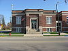 Montpelier’s Carnegie Library
 Montpelier’s First Baptist Church
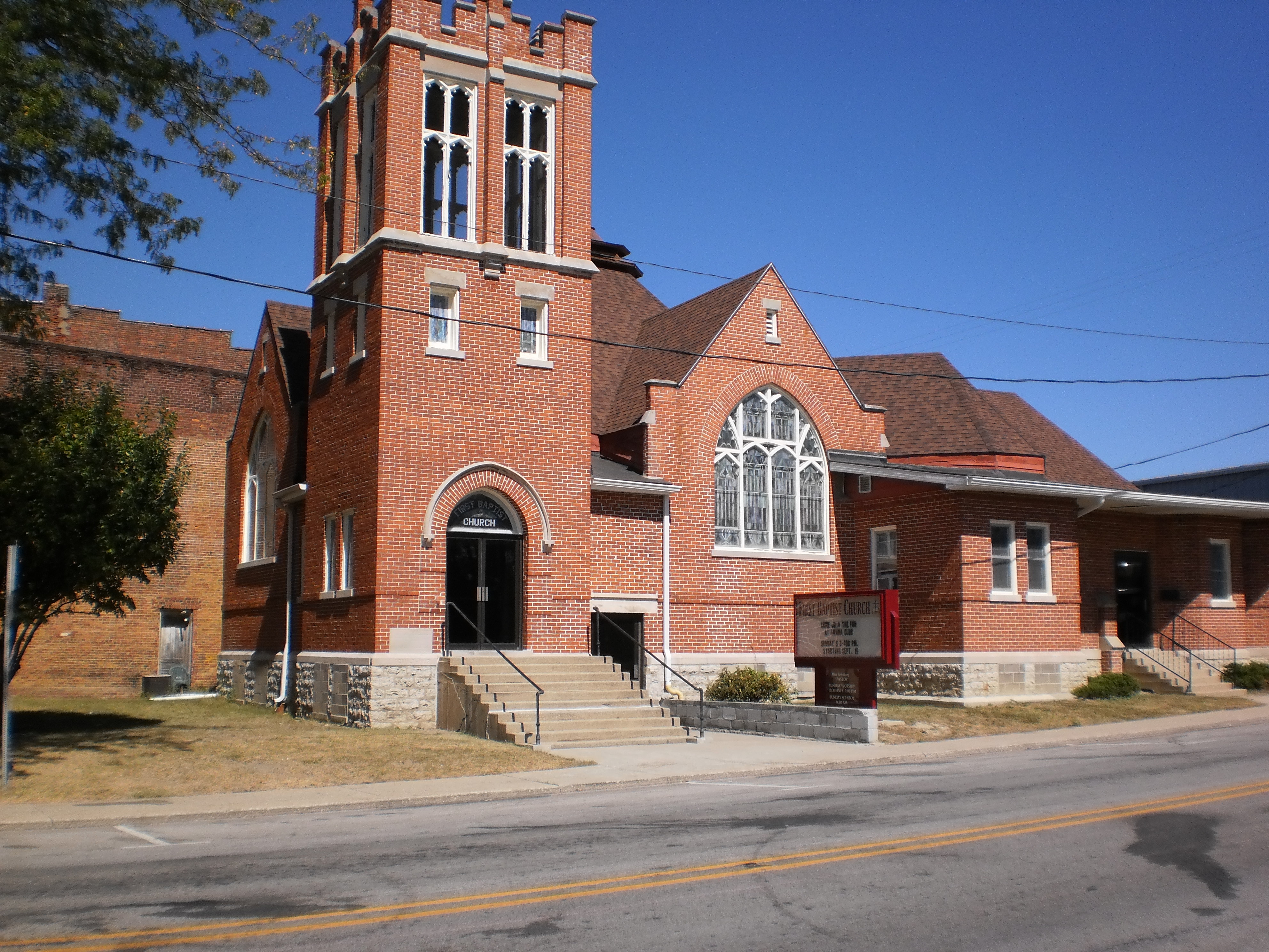
Montpelier has a long history of racing. During the 19th Century, there were at least two race tracks for horses near Montpelier. Montpelier’s own horse track was established in 1903.[23] This track was very popular and drew crowds of 3,000. During the 1920s, a rebuilt track became known as the fastest half mile in Indiana.[23] During the 1950s, the track became a stock car racing track, but reverted back to horses in the 1960s. The track closed in 1973, but reopened in 1985 for stock car races and horse racing. Today, Montpelier Raceway features sanctioned stock car racing.[22]
The Public Library of Montpelier and Harrison Township was built in 1907 and 1908.[24] The building was made possible by a donation of $10,000 from philanthropist (and former business magnate) Andrew Carnegie. Built in the Classical Revival style of architecture, this building (under the historical name of Montpelier Carnegie Library) was added to the National Register of Historic Places in 2007.[25] It is one of only three individual buildings in Blackford County listed in the National Register. (The county also has a Historic District.)
Montpelier’s First Baptist Church was founded by Franklin Baldwin, brother of the leader of Montpelier’s first settlers, Abel Baldwin.[26] The congregation was organized in 1838. The present church building, located in downtown Montpelier, was constructed in 1907 and 1908. The building has been remodeled since that time.
High School basketball is very popular in Indiana, and Montpelier has been a strong participant. Despite its smaller size, Montpelier High School won five sectional basketball tournament championships. After a high school consolidation, Montpelier students began attending Blackford High School – and Blackford has won ten sectional championships.[27] Additional sporting activities in Montpelier include Little League baseball, Tee Ball, and softball.[28] Golfing, camping, and fishing are also available nearby.
The Montpelier Jamboree is an annual celebration that was first held in 1945.[29] This Labor Day weekend celebration features musical acts, a Jamboree Queen contest, and other activities.[30]
The former Godfroy Reservation, an Indian reservation for Chief Francis Godfroy and Miami Indians from 1827 until 1836, is located on the Salamonie River near Montpelier.[31] (Francis is the English pronunciation of Godfroy’s real name Francois. The Indian pronunciation of Francois was Palonzwa.[32]) Godfroy’s father was French, and his mother was from the Miami tribe. A big man at six feet tall and 300 pounds, Godfroy was the last war chief of the Miami Nation.[33][34] A stature of Francis Godfroy is located in downtown Montpelier.
Infrastructure
Montpelier has its own elementary school, and high school students attend the county's Blackford High School. Five universities, including Ball State University and Taylor University, are located not more than 30 miles (48 km) from Montpelier.
The Norfolk Southern Railway provides freight railroad service connecting Montpelier to Fort Wayne and Indianapolis. This railroad, known as the Lake Erie and Western Railroad in the 1890s during the Gas Boom, was very important for the growth of Montpelier.[35][36] Indiana Highway 18 runs through Montpelier, and Interstate 69 is 14 miles (23 km) west. The nearest airport with commercial flights is located 40 miles (64 km) north in Fort Wayne.[37]
Major highways
 Indiana State Road 18
 Interstate 69 (14 miles (23 km) west of city)
Notable People
NASA astronaut Kevin A. Ford is one of Montpelier’s most notable former residents. A graduate of the local Blackford High School, Ford holds academic degrees from University of Notre Dame, Troy State University, University of Florida, and the Air Force Institute of Technology. Ford retired from active duty as a colonel in the United States Air Force in 2008. Ford was the pilot for the Space Shuttle Discovery during its August 2009 flight. He has logged over 332 hours in outer space.[38]
Notes
- ^ a b "American FactFinder". United States Census Bureau. http://factfinder.census.gov. Retrieved 2008-01-31.
- ^ "US Board on Geographic Names". United States Geological Survey. 2007-10-25. http://geonames.usgs.gov. Retrieved 2008-01-31.
- ^ a b Shinn, pp. 270-271.
- ^ a b A History of Blackford County…, p. 91.
- ^ Biographical and historical record of Jay and Blackford Counties…, p. 736. “Matamoras, a mile or two up the river, was started as a village even before Montpelier; but there’s nothing there now.”
- ^ A History of Blackford County…, p.19.
- ^ A History of Blackford County..., p. 46.
- ^ a b Blatchley, p. 71
- ^ A History of Blackford County..., p. 90, quoting the November 19, 1895 edition of the Montpelier Herald.
- ^ A History of Blackford County…., p. 92.
- ^ Rupp, “Oil and Gas in Indiana” web site.
- ^ Glass, p. 91
- ^ See U.S. Census population counts for Montpelier shown elsewhere in this article. See also page 16 of A History of Blackford County…..
- ^ Giradin, Helmer, and Mattix, page 24.
- ^ A History of Blackford County..., p. 104.
- ^ A History of Blackford County..., pp. 8-9.
- ^ A History of Blackford County..., p. 10.
- ^ DeLorme (1998). Indiana Atlas & Gazetteer. Yarmouth, Maine: DeLorme. ISBN 0-89933-211-0
- ^ From the Montpelier, Indiana web site.
- ^ "Montpelier Weather Records and Averages". Yahoo!. 2011. http://weather.yahoo.com/climo/USIN0439_f.html?woeid=2453515. Retrieved February 13, 2011.
- ^ A History of Blackford County..., p. 8.
- ^ a b Montpelier, Indiana web site.
- ^ a b A History of Blackford County…, pp. 98-99.
- ^ Leanard and Walker's National Register of Historic Places Registration: Montpelier Carnegie Library.
- ^ National Register of Historic Places weekly announcements web page for July 6, 2007.
- ^ A History of Blackford County…, p. 96.
- ^ The Indiana High School Athletic Association web site lists all sectional champions.
- ^ Montpelier, Indiana web site.
- ^ A History of Blackford County…, p. 97.
- ^ Montpelier, Indiana web site.
- ^ See Indiana Historical Bureau’s web page for the Godfroy Reserve marker. "Godfroy Marker" See also the Hoxie’s “Encyclopedia of North American Indians”, page 715.
- ^ Bodurtha, p. 36.
- ^ See historic marker for Godfroy burial place.
- ^ Bodurtha, p. 33.
- ^ Goltra, p. 79. Railroad sidings for Montpelier in 1895 are listed.
- ^ McIIwraith & Muller, p. 336.
- ^ Montpelier, Indiana web site Facts page 1.
- ^ NASA biography on web for Kevin A. Ford.
References
- A History of Blackford County, Indiana : with historical accounts of the county, 1838-1986 [and] histories of families who have lived in the county.. Hartford City, Indiana: Blackford County Historical Society. 1986. pp. 302. OCLC 15144953.
- Biographical and historical record of Jay and Blackford Counties, Indiana: Containing ... portraits and biographies of some of the prominent men of the state : engravings of prominent citizens in Jay and Blackford Counties, with personal histories of many of the leading families and a concise history of Jay and Blackford Counties and their cities and villages. Chicago: The Lewis Publishing Company. 1887. pp. 901. OCLC 15560416. http://contentdm.lib.byu.edu/cdm4/document.php?CISOROOT=/FH26&CISOPTR=36087&CISOSHOW=35182.
- Blatchley, W. S. (1897). Indiana Department of Geology and Natural Resources, Twenty-First Annual Report (1896). Indianapolis: Indiana Department of Geology and Natural Resources. pp. 718. OCLC 7536715. http://books.google.com/books?id=_w4MAAAAYAAJ&pg=PA71&dq=Blackford+This+county+comprises+but+165+square+miles#v=onepage&q=Blackford%20This%20county%20comprises%20but%20165%20square%20miles&f=false.
- Bodurtha, Arthur L. (1914). History of Miami County, Indiana : a narrative account of its historical progress, its people and its principal interests. Chicago: The Lewis Publishing Company. pp. 830. OCLC 12587645. http://books.google.com/books?id=gRgVAAAAYAAJ&printsec=frontcover&dq=History+of+Miami+County+Indiana+Bodurtha#v=onepage&q=&f=false.
- Girardin, G. Russell; Helmer, William J.; Mattix, Rick (2005). Dillinger: the untold story. Bloomington, Indiana: Indiana Univ. Press. pp. 379. ISBN 0253216338. OCLC 249370753. http://books.google.com/books?id=w1rFmxkYxaQC&pg=PA24&lpg=PA24&dq=dillinger+montpelier#v=onepage&q=dillinger%20montpelier&f=false.
- Glass, James A.; Kohrman, David (2005). The Gas Boom of East Central Indiana. Charleston, SC: Arcadia. pp. 128. ISBN 0738539635. OCLC 61885891. http://books.google.com/?id=C02PktLMIx8C&pg=PA91&lpg=PA91&dq=gas+boom+ghost+town+indiana.
- Goltra, W. F. (1895). Characteristics of the Lake Erie & Western Railroad System. Indianapolis: Press of Levey Bros. & Co.. pp. 102. OCLC 7147894. http://books.google.com/books?id=6VsrAAAAYAAJ&pg=PA79&dq=%22Mollie+loading+track%22#v=onepage&q=%22Mollie%20loading%20track%22&f=false.
- Hoxie, Frederick E. (1996). Encyclopedia of North American Indians. Boston: Houghton Mifflin Company. pp. 738. ISBN 0585077649 9780585077642 0395669219 9780395669211. OCLC 34669430.
- Indiana High School Athletic Association (February 27, 2011). "Indiana High School Athletic Association". http://www.ihsaa.org/. Retrieved February 20, 2011.
- Indiana State Board of Agriculture; Indiana Geological Survey (1891). Annual report of the Indiana State Board of Agriculture. Indianapolis: State Board of Agruculture. pp. 543. OCLC 4948696. http://books.google.com/books?id=E44ZAQAAIAAJ&pg=PA279&lpg=PA279&dq=Montpelier+oil+fields+Indiana#v=onepage&q&f=false.
- Leonard, Craig; Walker, Amy (January 1980), National Register of Historic Places Registration Form: Montpelier Carnegie Library, National Park Service, pp. 12 (plus photos), http://www.in.gov/dnr/historic/files/montpelier_lib_all.pdf
- McIlwraith, Thomas F.; Muller, Edward K. (2001). North America: the historical geography of a changing continent. Lanham, Maryland: Lanham [u.a.] : Rowman & Littlefield. pp. 501. ISBN 0742500187. OCLC 248646178. http://books.google.com/books?id=8NS0OTXRlTMC&pg=PA336&lpg=PA336&dq=small+towns+railroads+automobile#v=onepage&q=small%20towns%20railroads%20automobile&f=false.
- NASA (February 18, 2011). "NASA". http://www.nasa.gov/. Retrieved February 20, 2011.
- Rupp, John A. (2008). "Oil and Gas in Indiana". Indiana Geological Survey. http://igs.indiana.edu/geology/coalOilGas/oilandgas/index.cfm. Retrieved 2011-02-26.
- Shinn, Benjamin Granville (1900). Biographical memoirs of Blackford County, Ind: to which is appended a comprehensive compendium of national biography ... embellished with portraits of many well known residents of Blackford County, Indiana. Chicago: The Bowen Publishing Company. pp. 750. OCLC 3554406. http://books.google.com/books?id=ZCNIPQAACAAJ&dq=Biographical+Memoirs+of+Blackford+County,+Indiana.
External links
Municipalities and communities of Blackford County, Indiana Cities Dunkirk‡ | Hartford City | Montpelier

Town Townships Harrison | Jackson | Licking | Washington
Unincorporated
communitiesFootnotes ‡This populated place also has portions in an adjacent county or counties
Categories:- Cities in Indiana
- Populated places in Blackford County, Indiana
- Indiana articles needing reassessment


Wikimedia Foundation. 2010.