- Indiana State Road 14
Infobox road
state=IN
type=IN
route=14
alternate_name=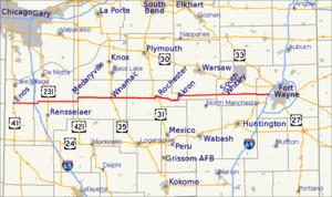
length_mi=123
length_round=
length_ref= [http://illi-indi.com/EndsPage.php?id=1014§ion=1 Indiana Highway Ends - SR 14] ]
established=
direction_a=West
starting_terminus=
junction=
direction_b=East
ending_terminus=
counties=Allen, Fulton, Jasper, Kosciusko, Newton, Pulaski, Whitley
previous_type=IN
previous_route=13
next_type=IN
next_route=15State Road 14 is an east-west road in
northern Indiana . Its western terminus is atU.S. Route 41 in Enos, and its eastern terminus is atInterstate 69 in Fort Wayne. It passes through these cities and towns, from west to east:*Enos
*Winamac
*Rochester
*Akron
*Silver Lake
*South Whitley
*Fort WayneIn August 2005, construction on a new ramp connecting Indiana State Road 14 to Interstate 65 was completed. Winamac is the only control city listed, and is approximately 40 miles east of the interchange. The ramp is noted for direct access to Fair Oaks Farms, immediately west of the interchange.
Major intersections
Source: INDOT Roadway Referencing System [cite web|url=http://www.in.gov/indot/3361.htm|title=INDOT Roadway Referencing System] INint
county=Newton
cspan=2
mile=0.00
road=
location=Enos
lspan=2
notes=SR 14 beginsINint
mile=6.10
road=INint
county=Jasper
cspan=2
mile=9.39
road=
notes=overpass
location=Jasper County
lspan=2INint
mile=22.06
road=INint
county=Pulaski
cspan=5
mile=30.07
road=
type=concur
notes=concurrency begins
location=Pulaski County
lspan=3INint
mile=32.08
road=
type=concur
notes=concurrency ends after 2.01 milesINint
mile=38.05
road=INint
mile=46.98
road=
type=concur
notes=concurrency begins
location=Winamac
lspan=2INint
mile=47.10
road=
type=concur
notes=concurrency ends after 0.12 milesINint
county=Fulton
cspan=5
mile=56.56
road=
location=Fulton County
lspan=2INint
mile=66.17
road=INint
mile=67.34
road=
type=concur
notes=concurrency begins
location=Rochester
lspan=2INint
mile=69.29
road=
type=concur
notes=concurrency ends after 1.95 milesINint
mile=78.31
road=
location=AkronINint
county=Kosciusko
cspan=2
mile=87.68
road=
location=Silver LakeINint
mile=95.46
road=
location=Kosciusko CountyINint
county=Whitley
cspan=3
mile=101.69
road=
type=concur
notes=concurrency begins
location=South Whitley
lspan=3INint
mile=102.33
road=
type=concur
notes=concurrency ends after 0.64 milesINint
mile=110.26
road=INint
county=Allen
mile=122.98
road=
notes=overpass
location=Fort WayneReferences

Wikimedia Foundation. 2010.