- Mineral City, Ohio
-
"Mineral City" redirects here. For the location in Indiana, see Mineral City, Indiana.
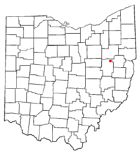
Mineral City, Ohio — Village — Victorian homes on Ohio State Route 800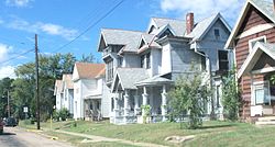 Location of Mineral City, Ohio
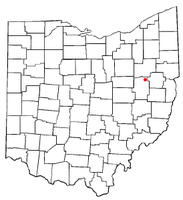
Coordinates: 40°36′8″N 81°21′40″W / 40.60222°N 81.36111°WCoordinates: 40°36′8″N 81°21′40″W / 40.60222°N 81.36111°W Country United States State Ohio County Tuscarawas Township Sandy Area – Total 0.8 sq mi (2.1 km2) – Land 0.8 sq mi (2.1 km2) – Water 0.0 sq mi (0.0 km2) Elevation[1] 945 ft (288 m) Population (2000) – Total 841 – Density 1,036.6/sq mi (400.2/km2) Time zone Eastern (EST) (UTC-5) – Summer (DST) EDT (UTC-4) ZIP code 44656 Area code(s) 330 FIPS code 39-50764[2] GNIS feature ID 1057850[1] Mineral City is a village in Tuscarawas County, Ohio, United States. The population was 841 at the 2000 census.
Contents
Geography
Mineral City is located at 40°36′8″N 81°21′40″W / 40.60222°N 81.36111°W (40.602164, -81.361242)[3].
According to the United States Census Bureau, the village has a total area of 0.8 square miles (2.1 km2), all of it land.
History
Mineral City was platted in 1853.[4]
Demographics
Historical populations Census Pop. %± 1870 175 — 1880 642 266.9% 1890 893 39.1% 1900 1,220 36.6% 1910 1,032 −15.4% 1920 800 −22.5% 1930 840 5.0% 1940 820 −2.4% 1950 831 1.3% 1960 917 10.3% 1970 860 −6.2% 1990 725 — 2000 841 16.0% 2010 727 −13.6% [5]
As of the census[2] of 2000, there were 841 people, 306 households, and 235 families residing in the village. The population density was 1,036.6 people per square mile (400.9/km²). There were 331 housing units at an average density of 408.0 per square mile (157.8/km²). The racial makeup of the village was 98.22% White, 0.24% Native American, 0.48% from other races, and 1.07% from two or more races. Hispanic or Latino of any race were 1.43% of the population.There were 306 households out of which 37.9% had children under the age of 18 living with them, 58.2% were married couples living together, 14.7% had a female householder with no husband present, and 23.2% were non-families. 18.3% of all households were made up of individuals and 7.2% had someone living alone who was 65 years of age or older. The average household size was 2.75 and the average family size was 3.12.
In the village the population was spread out with 30.0% under the age of 18, 8.0% from 18 to 24, 30.8% from 25 to 44, 22.1% from 45 to 64, and 9.2% who were 65 years of age or older. The median age was 34 years. For every 100 females there were 102.2 males. For every 100 females age 18 and over, there were 96.3 males.
The median income for a household in the village was $35,526, and the median income for a family was $38,375. Males had a median income of $28,958 versus $20,357 for females. The per capita income for the village was $13,498. About 7.6% of families and 8.9% of the population were below the poverty line, including 7.9% of those under age 18 and 10.0% of those age 65 or over.
References
- ^ a b "US Board on Geographic Names". United States Geological Survey. 2007-10-25. http://geonames.usgs.gov. Retrieved 2008-01-31.
- ^ a b "American FactFinder". United States Census Bureau. http://factfinder.census.gov. Retrieved 2008-01-31.
- ^ "US Gazetteer files: 2010, 2000, and 1990". United States Census Bureau. 2011-02-12. http://www.census.gov/geo/www/gazetteer/gazette.html. Retrieved 2011-04-23.
- ^ J. M. Richardsson, A Brief History of Tuscarora County
- ^ census data: 1870, 1880 : Mansfield, J.B. (1884). The History of Tuscarawas County. Warner, Beers & Co.. p. 649. http://books.google.com/books?id=5DguAAAAYAAJ&pg=PA649. , 1890,1900 : Hunt, William C. (1901). Population of the United States by states and territories, counties, and minor Civil Divisions, as returned at the Twelfth Census: 1900. United States Census Printing Office. p. 319. http://books.google.com/books?id=Pnk9AAAAYAAJ&pg=PA319. , 1910, 1920, 1930 : 1930 page 57 , 1940, 1950 : 1950 page 26 , 1960, 1970 : 1970 page=144 , 1990 : 1990 , 2000 : 2000
Municipalities and communities of Tuscarawas County, Ohio Cities 
Villages Baltic‡ | Barnhill | Bolivar | Dennison | Gnadenhutten | Midvale | Mineral City | Newcomerstown | Parral | Port Washington | Roswell | Stone Creek | Strasburg | Sugarcreek | Tuscarawas | Zoar
Townships Unincorporated
communitiesBernice | Dundee | Gilmore | New Cumberland | Newport | Peoli | Sandyville | Somerdale | Stillwater | Wainwright
Footnotes ‡This populated place also has portions in an adjacent county or counties
Categories:- Villages in Ohio
- Populated places in Tuscarawas County, Ohio
- Populated places established in 1853


Wikimedia Foundation. 2010.