- Mineral King
-
Mineral King Valley 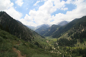
Mineral King Valley from Timber Gap TrailLocation Sequoia National Park, Sierra Nevada, Tulare County, California Length 7 miles (11 km) Average width 1 mile (1.6 km) Primary watercourses East Fork Kaweah River, Franklin Creek, Crystal Creek Nearest city Three Rivers Coordinates 36°16′13″N 118°21′15″W / 36.2703°N 118.3541°W Added to NHRP: October 24, 2003 NRHP Reference#: 03001063[1] Mineral King is a subalpine glacial valley located in the southern part of Sequoia National Park, in the U.S. state of California.[2] The valley lies at the headwaters of the East Fork of the Kaweah River, which rises at the eastern part of the valley and flows northwest. Accessed by a long and narrow winding road, the valley is mostly popular with backpackers and hikers.
Historically, the valley was inhabited by the Yokut tribe, then in the 1870s, silver was discovered on the slopes of a mountain overlooking Mineral King. Mineral King Road was built in 1873 and was gradually improved throughout the early 20th century. A proposal by The Walt Disney Company to build a ski resort in the valley in the 1960s was stopped by preservationists. In 1978, the valley became part of Sequoia National Park.
The name Mineral King also refers to the historic mining camps and towns in and near the valley, including Silver City and Cabin Cove. The settlements as a whole are referred to as the Mineral King Road Cultural Landscape, and was added to the National Register of Historic Places in 2003.
Contents
Geography
Mineral King is a 7.5-mile (12.1 km)-long, 1-mile (1.6 km)-wide glacial valley in the southern Sierra Nevada. The valley floor lies at an elevation of 7,400 feet (2,300 m), while the granite peaks rising above the head of the valley reach heights of 11,000 feet (3,400 m) or more. As the crow flies, it is located about 20 miles (32 km) southeast of Three Rivers, which is near the confluence of the East Fork Kaweah River and Middle Fork Kaweah River.
The valley floor is an expanse of open meadows with a narrow strip of riparian vegetation, including short trees and bushes, along the East Fork Kaweah River. As the flat meadows give way to rocky slopes, there are many congregations of conifers that climb the slopes to the tree line. Above the tree line, there are sheer or almost sheer granite walls that slope up to form Sawtooth Peak, Empire Mountain, Mineral Peak, Hengst Peak and others. There are two prominent mountain passes leading out of Mineral King: Timber Gap, which leads into the Middle Fork Kaweah River drainage' and Farewell Gap at the valley head, which leads into the Kern River drainage. The first half of the valley runs from south to north and the second half runs from east to west.
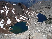 The Franklin Lakes lie at the headwaters of Mineral King and feed Franklin Falls.
Fed by snowmelt, springs and abundant lakes in granite bowls at the upstream-most section of the valley, creeks plunge down the steep valley walls as long and twisting waterfalls. These include Tufa Falls, Crystal Creek Falls, and Franklin Falls, in upstream order. This section of the valley is dotted with tributary gorges that fan out from the main canyon. Lakes in this section of the valley include the Mosquito Lakes, Eagle Lake, the Franklin Lakes, and the Crystal Lakes. From the end of the valley, the East Fork Kaweah River drops over Mineral King Falls and East Fork Falls, before continuing down a steep and narrow gorge, following Mineral King Road.
Cabin groups
Mineral King is one of the oldest communities in the High Sierra, with many families owning cabins for six or seven generations. Many of the communities date from the 1870s silver boom, and have continued to be inhabited ever since.[3]
One mile before reaching the Mineral King cabins is a grouping of 30 or so cabins in an area named Faculty Flat. The Faculty Flat cabins were mostly built in the 1920s and many are listed in the National Register of Historic Places. The name Faculty Flat derives from a group of Los Angeles educators that originally populated the area.
Another group of about 50 cabins is about 4 miles (6.4 km) down the road from Mineral King in a small community called Silver City. Silver City has the only commercial services available anywhere in the region and is the site of the Silver City Resort.
Just down the road from Silver City is an even smaller community of about a dozen cabins, called Cabin Cove. Nearby is the Atwell Mill public campground whose name relates to a sawmill facility dating back to one hundred or more years ago. Excluding Silver City, all of these communities belong to the Mineral King Road Cultural Landscape District.[4]
History
Evidence suggests that Native Americans long ago used Mineral King to camp and hunt in. These Native American groups included the Wikchúmni Yokut (or Wukchumni) and the Tübatulabal.[4] The Yokuts' main settlements actually had their main villages in the broad valley adjoining and in the present-day site of Lake Kaweah. They created summer settlements on the valley floor and also around the area that was later to be the site of Atwell Mill. The primary purpose of these summer settlements was hunting and trading with the Paiutes, who lived east of the Sierra Nevada.[5] But prior to contact with white settlers, the valley became taboo to the Wikchúmni Yokut tribe, and no humans had inhabited it for some time.
The first explorer of European descent known to have visited Mineral King was the Irishman Harry "Parole" O'Farrell, in 1862. While employed as hunters for a trail crew building the Hockett toll trail from Visalia to Independence, O'Farrell and a Paiute companion found the valley from the south, over Farewell Gap. Attracted by the promise of mineral riches, O'Farrell returned to prospect and build a summer settlement on the East Fork of the Kaweah River, which came to be called Harry's Bend. In the 1870s and 1880s, assays of precious metals in White Chief Canyon and on Empire Mountain led to the boomtown of Beulah. The first discovery of silver in the Mineral King Valley occurred in 1872, below Mineral Peak and Empire Mountain. Following the discovery, the first road to Mineral King was created in 1873 by the Mineral King Wagon and Toll Road Company.[6]
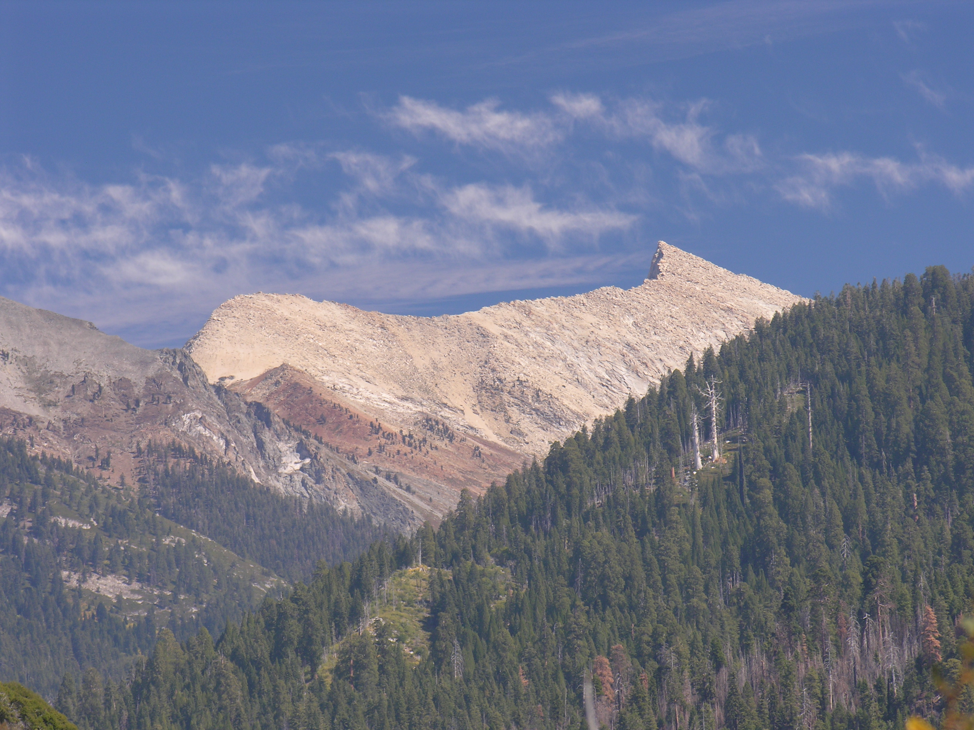
 Silver was discovered near Sawtooth Peak in the 1870s.
The first routing of Mineral King Road followed the East Fork Canyon's south side. A second discovery of silver in 1878 drew more prospectors to the Mineral King area and a second Mineral King Road, following a different route up the north side of the canyon, was constructed in 1879.[6] This created the route for much of the present-day Mineral King Road. A Tom Fowler purchased the Empire Mine, then the largest mine in the area, and created the Empire Gold and Silver Mining Company. The lowermost part of the road was rebuilt in 1915 to its present-day route.[6] Over time, the minerals were found to be unprofitable to extract from their ore, but the valley kept its hopeful name: Mineral King.[7]
By the 1920s, Mineral King had begun to be used as a summer camping and recreational area. Continuing until 1942, private cabins were built in the Mineral King area, expanding the communities of Cabin Cove, Silver City, and Beulah. (All of these communities, including Silver City, would later become part of the National Register of Historic Places' Mineral King Road Cultural Landscape.) In 1926, Mineral King was declared the Sequoia Game Refuge by the United States Congress. Disney's Mineral King Ski Resort was a project developed by Walt Disney and Company in the 1960s. Disney had become interested in skiing around this time, and decided to build a ski resort in the Mineral King Valley. At the time, many skiers believed this to be the largest potential resort in all of California. Disney's bid won out over those of other developers, having the largest plans. Disney had also met renowned University of Denver and Olympic ski coach Willy Schaeffler, and together they developed the village and mountain resort plans.[8]
Conversely, the Sierra Club supported the ski resort proposal during the embryonic stages of its development. Its original plans then were changed to a massive proposal involving the construction of 14 ski lifts, and hotels and massive parking areas. The final plan called for 27 ski lifts and facilities for 2 million visitors per year. It was at this time that the Sierra Club announced its opposition to the project. The ski resort was never built, due to environmental concerns raised by a coalition of preservationists, led by the Sierra Club.[8] After years of legal battles between pro-development and preservationist groups, the Mineral King Valley was annexed into Sequoia National Park in 1978 by an act of Congress. That legislation effectively stopped the plan to ever develop the area into a ski resort.[8]
Natural history
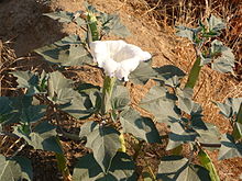 Sacred Detura off Mineral King Road
Upper Mineral King remains much like its original, natural state, while lower Mineral King has received some development. The valley is abundant in wildlife, including black bears, mule deer, yellow-bellied marmots, and some species of freshwater fish. Mining activities throughout the silver boom severely hurt the ecology of the lower East Fork below the Empire mine and White Chief Canyon,[9] but wildlife has slowly rebounded.
Recreation
The Mineral King Valley is accessed by a long, narrow, winding mountain road that leads 25 miles (40 km) generally southeast from the junction with Highway 198 near Three Rivers. At the end of the road is the Mosquito-Eagle Trailhead, which allows hikers to access trails leading out of the south end of the valley. There are also hiking trails leading north out of the valley through Timber Gap.
There are no commercial services available anywhere in the Mineral King Valley and visitors bring virtually all their food, camping supplies, firewood, and other essentials with them. None of the cabins have electricity and most utilize propane for lighting and cooking with fireplaces providing heating. There are a few public telephones scattered throughout the Mineral King Valley, notably at the Cold Springs campground, a trail head parking lot, and at the very end of the road. Cell phones do not work in the valley because of the remoteness of the area and the steep terrain. There are at least two webcams[10] that provide year-round visibility into the Mineral King Valley.
No gasoline is available anywhere after leaving State Route 198, 25 miles down the winding Mineral King road (a 90 minute drive). The National Park Service charges fees for utilizing campsites both at Cold Springs and Atwell Mill. Bears, marmots and other wild animals abound so campers take precautions to protect their food and vehicles. Suggested precautions are posted by the Park Service at the public campgrounds. Camping is not permitted in any location along the road except in the public campgrounds.
Preservation
There are two groups devoted to preserving Mineral King:
- The Mineral King District Association, whose main focus is on attaining recognition of Mineral King as a living historic community.[3]
- The Mineral King Preservation Society, which is nonprofit, public benefit corporation dedicated to preserving the natural and historic assets of the Mineral King area. Since its inception in 1986, the society has engaged in research, restoration, and preservation planning. Among its other activities is a new partnership with Sequoia National Park to insure preservation of all historic resources in the National Register listed area and assist in volunteer projects and educational activities.[11]
References
- ^ "National Register Information System". National Register of Historic Places. National Park Service. 2008-04-15. http://nrhp.focus.nps.gov/natreg/docs/All_Data.html.
- ^ "Mineral King (Populated Place)". Geographic Names Information System, U.S. Geological Survey. 19 January 1981. http://geonames.usgs.gov/pls/gnispublic/f?p=gnispq:3:::NO::P3_FID:1667918. Retrieved 2009-09-12.
- ^ a b "Mineral King District Association". www.mineralking.us. 6/7/09 (last update). http://www.mineralking.us/.
- ^ a b "Mineral King Road Cultural Landscape District". U.S. National Park Service. National Park Service Cultural Landscapes Inventory. 2008. http://www.nps.gov/seki/parkmgmt/upload/SEKI%20Mineral%20King%20Road%20CLI%20certified_600dpi.08.pdf. Retrieved 2009-09-12.
- ^ "History of the Living Historic Community". The Preservation of Mineral King. www.mineralking.org. http://www.mineralking.org/historicalinsights/historyOfLivingHistCom.htm. Retrieved 2009-09-12.[dead link]
- ^ a b c "The Mineral King Road Corridor: The Way to Mineral King". The Preservation of Mineral King. www.mineralking.org. http://www.mineralking.org/historicalinsights/TheWaytoMineralKing.htm. Retrieved 2009-09-12.[dead link]
- ^ Jackson, Louise A.. Beulah: a biography of the Mineral King Valley of California. Tucson, Arizona: Westernlore Press. ISBN 0-87026-065-0. OCLC 17830966.
- ^ a b c Dilsaver, L.M.; Tweed, W.C. (1990). "New Directions and a Second Century (1972-1990)". Challenge of the Big Trees. Sequoia Natural History Association. http://www.nps.gov/history/history/online_books/dilsaver-tweed/chap9c.htm.
- ^ "The saga of Mineral King". High Country News. February 2, 2009. http://www.hcn.org/wotr/the-saga-of-mineral-king. Retrieved 2009-09-12.
- ^ "Mineral King Webcam". http://www.mk-webcam.net/.
- ^ "The Mineral King Preservation Society". http://www.mineralking.org.
External links
U.S. National Register of Historic Places Topics Lists by states Alabama • Alaska • Arizona • Arkansas • California • Colorado • Connecticut • Delaware • Florida • Georgia • Hawaii • Idaho • Illinois • Indiana • Iowa • Kansas • Kentucky • Louisiana • Maine • Maryland • Massachusetts • Michigan • Minnesota • Mississippi • Missouri • Montana • Nebraska • Nevada • New Hampshire • New Jersey • New Mexico • New York • North Carolina • North Dakota • Ohio • Oklahoma • Oregon • Pennsylvania • Rhode Island • South Carolina • South Dakota • Tennessee • Texas • Utah • Vermont • Virginia • Washington • West Virginia • Wisconsin • WyomingLists by territories Lists by associated states Other Categories:- Valleys of California
- Sequoia National Park
- Landforms of Tulare County, California
- National Register of Historic Places in California
- 1915 architecture
- Unrealized Disney attractions
- Sierra Nevada (U.S.)


Wikimedia Foundation. 2010.