- Dead Man's Curve
-
 Dead Man's Curve in Cleveland, Ohio
"Dead Man's Curve" is the unofficial but commonly used name given to hazardous curves on Interstate Highways and other roads in the United States that have claimed lives because of accidents.
Contents
Cleveland Innerbelt
One such curve is the nearly 90-degree turn on Interstate 90 near downtown Cleveland, Ohio, officially the Innerbelt Curve,[1] at the point where the Cleveland Memorial Shoreway connects to the Innerbelt Freeway just south of Burke Lakefront Airport.[2] The advisory speed is 35 miles per hour (60 kilometers per hour), although the maximum safe speed limit is 50 mph (80 km/h), as on adjacent sections of the Shoreway and Innerbelt.
Dead Man's Curve was constructed as part of the Innerbelt project in 1959. It soon became apparent that the curve was too sharp for travel at typical Interstate speeds, and in 1965, the state lowered the speed limit from 50 mph (80 km/h) to 35 mph (56 km/h). Four years later, authorities completed the first set of safety retrofits, which included banking the curve and installing rumble strips and large signs.[3]
According to the Ohio Department of Transportation (ODOT), the crash rate on the Innerbelt (which includes Dead Man's Curve) is two to three times the regional average for urban freeways, despite the reduced speed limits on the roadway. The department is investigating ways of enhancing safety on the stretch, including a complete realignment of the roadway to reduce the degree of the curve. According to a 2003 ODOT count, 95,090 vehicles travel on the curve every day.
The official ODOT name for the curve is the Innerbelt Curve,[4] but the nickname "Dead Man's Curve" is commonly used colloquially and in traffic reports.
According to the Innerbelt Reconstruction Plan, Dead Man's Curve will eventually be softened.
Other sharp curves
Other roads and highways have sections known as Dead Man's Curve:
- A sharp turn in the shape of a "U" on SR 76 in San Diego County, California, near Red Gate Road. This curve has claimed the lives of many motocyclists.
- A stretch of Sunset Boulevard in Los Angeles, California was immortalized by Jan and Dean in the song "Dead Man's Curve." It is located near the Bel Air estates just north of UCLA's Drake Stadium.[5]
- Interstate 83 (Jones Falls Expressway) in Baltimore, MD,[6]
- Interstate 20 just east of the Birmingham, Alabama airport, at its junction with Interstate 59; engineers were forced to build a curve into the highway to avoid a cemetery.[7]
- Interstate 59 about 10 miles north of Gadsden, Alabama. The s-shaped had to be built to avoid running straight up in to a steep mountain.
- A sharp turn in a series of sharp bends on Kali Oka Road, located in Saraland, Alabama just south of a Crybaby Bridge.
- A sharp bend in U.S. Route 50 (Columbia Parkway) east of Cincinnati, Ohio.[8]
- A sharp turn on eastbound Interstate 70 near Morrison, Colorado that is preceded by a seven mile (11 km) stretch of a 6.5% grade hill, which has been the site of numerous fatal runaway truck accidents.[9][10]
- A treacherously sharp turn at the end of Kapaa Quary Road, a dimly lit utility road in Kailua, Oahu HI. It has already claimed eight fatalities and is considered one of Oahu's haunted roads. http://www.hauntedhawaii.net/ghost_hunting___3.170.html#Ghost%20Hunting%20-%203 http://www1.honolulu.gov/refs/nco/nb31/08/31febmin.htm
- A treacherous stretch of Interstate 75 in Northern Kentucky originally known as "Death Hill" and now known as "Cut-in-the-Hill".[11]
- A sharp, sudden turn on U.S. Route 175 (C. F. Hawn Freeway) at the interchange with SH 310 southeast of downtown Dallas, Texas.[12] After a fatal truck accident in 2008, TxDOT installed additional beacons and also flashing chevrons to further draw motorists' attention to the hazard at this location. As of 2010, TxDOT is studying plans to eliminate this curve by extending the C. F. Hawn Freeway westward to Interstate 45.
- Sharp turn on Interstate 75 just north of downtown Dayton, Ohio.[13]
- Sharp turn on Missouri State Route 34 just east of Garwood, Missouri in Reynolds County.
- A sharp 90-degree turn on New York State Route 17 in Binghamton, New York, near the junction of the highway with Interstate 81 and Interstate 88, also goes by the name Kamikaze Curve. The tight curve, which hugs Prospect Mountain along the Chenango River, is slated for improvements as part of NY 17's upgrade to Interstate 86.
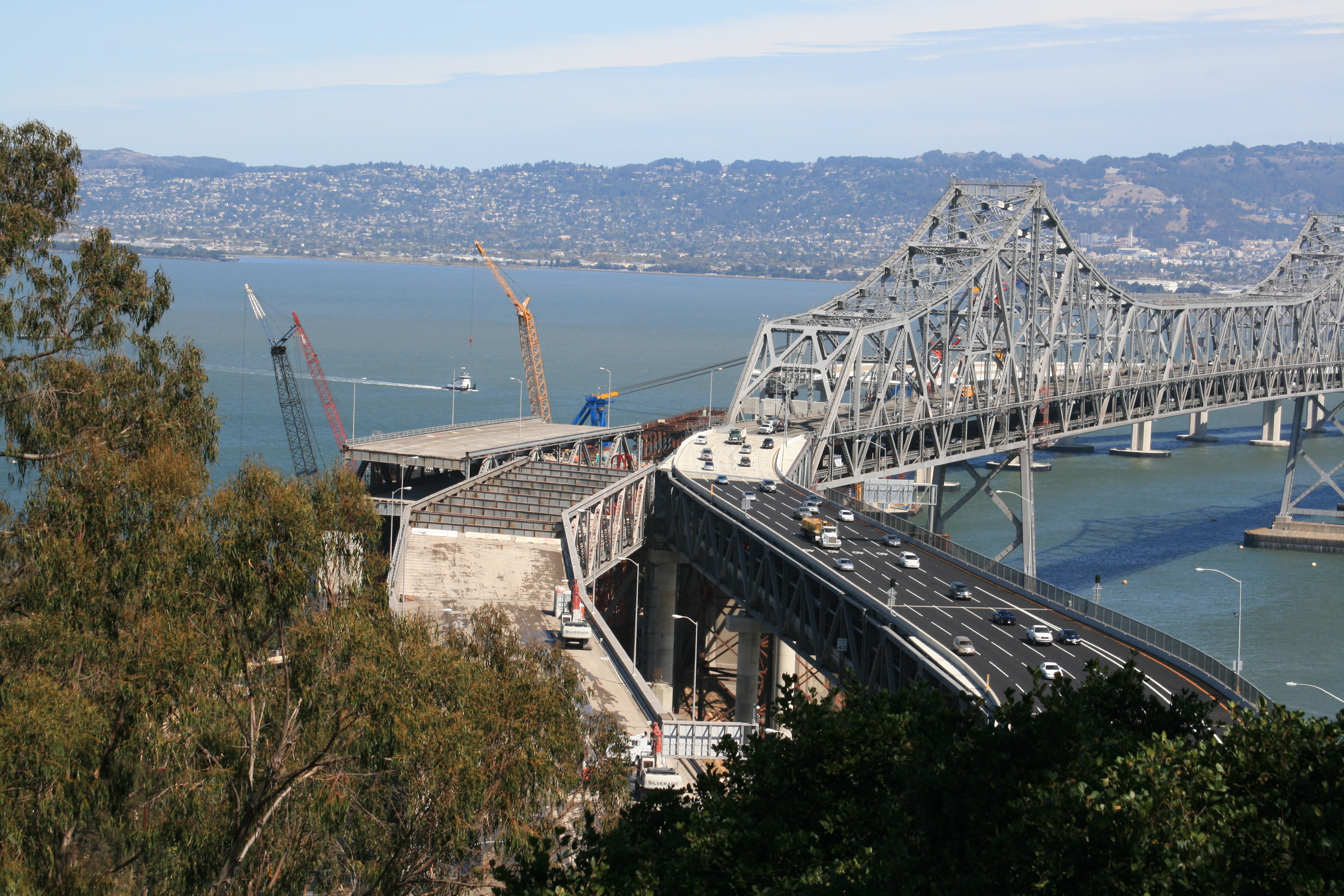
 The new S-shape connector on the San Francisco–Oakland Bay Bridge, as seen on September 29, 2009, from the U.S. Coast Guard station on Yerba Buena Island
- A temporary S-shape curve on the Eastern span of the San Francisco–Oakland Bay Bridge (part of Interstate 80). Since its installation on September 8, 2009, to divert traffic as part of the replacement project, 43 accidents have occurred, including 1 fatal crash.[14]
- On the Mount Hood Scenic Byway between Zigzag and Government Camp[15]
- The northern terminus of Interstate 476 in Clarks Summit, Pennsylvania is a 180-degree turn, with an advisory speed limit of 20 mph, created in order to access a toll plaza before interchanging with Interstate 81.
- In Marquette Township, Marquette County, Michigan, Dead Man's Curve referred to a curve on M-15 (now a former section of County Road 492) where the first center stripe in the United States was painted.[16]46°31′54″N 87°28′26″W / 46.5318°N 87.474°W
- On U.S. Route 22 in Easton, Pennsylvania, there are several dangerous sharp turns that go past a graveyard.[17] (This is most commonly known as "Cemetery Curve" for that reason.) Streetlights were installed to help cut down on nighttime crashes; the lightposts are themselves frequent victims of collisions.[18]
- In northern Bossier Parish, Louisiana, a sharp curve on Louisiana 157 (Hickory Drive) just inside the city limits of Plain Dealing, Louisiana south of the town cemetery.[19]
- In Indianapolis, Indiana, a curve on Interstate 70 west bound at mile marker 83.1[20] When originally opened, it had a negative bank on the right shoulder and several truckers lost control and impacted the following bridge abutment, losing their lives. The new stretch was closed, re-engineered with a positive bank and rain slots along the boundary, and reopened with a 40MPH speed limit.
References
- ^ Chapter 4.0: Conceptual Alternatives – Innerbelt Curve. Cleveland Innerbelt: Conceptual Alternatives Study (2006-08-11). Ohio Department of Transportation.
- ^ Google Maps view of curve in Cleveland
- ^ Cabanatuan, Michael (November 11, 2009). "Ideas offered to slow S-curve motorists". San Francisco Chronicle. http://www.sfgate.com/cgi-bin/article.cgi?f=/c/a/2009/11/11/MNUJ1AIA3G.DTL. Retrieved November 11, 2009.
- ^ Chapter 4.0: Conceptual Alternatives – Innerbelt Curve, Cleveland Innerbelt: Conceptual Alternatives Study, Ohio Department of Transportation/Burgess & Niple/URS Corporation, 2006-08-11. Retrieved 2008-06-18.
- ^ Google Maps view of curve in Los Angeles (Sunset Blvd)
- ^ Google Maps view of curve in Baltimore
- ^ Google Maps view of curve in Birmingham
- ^ Google Maps view of curve in Cincinnati
- ^ Google Maps view of curve in Colorado
- ^ Gathright, Alan (2007-07-12). "Stretch of I-70 has deadly legacy". Rocky Mountain News. Archived from the original on 2007-07-14. http://web.archive.org/web/20070714222750/http://www.rockymountainnews.com/drmn/local/article/0,1299,DRMN_15_5626064,00.html. Retrieved 2007-07-13
- ^ Google Maps view of curve in Covington, Kentucky
- ^ Google Maps view of curve in Dallas
- ^ Google Maps view of curve in Dayton
- ^ Lee, Henry K.; Michael Cabanatuan & Jaxon Van Derbeken (November 10, 2009). "Changes coming to Bay Bridge after death plunge". San Francisco Chronicle. http://www.sfgate.com/cgi-bin/article.cgi?f=/c/a/2009/11/09/BAAE1AHDO3.DTL. Retrieved November 11, 2009.
- ^ Google Maps view of curve in on the Mount Hood Scenic Byway
- ^ Kulsea, Bill; Shawver, Tom (1980). Making Michigan Move: A History of Michigan Highways and the Michigan Department of Transportation. Lansing, MI: Michigan Department of Transportation. p. 10.
- ^ Google Maps view of curve in Easton
- ^ "Shine the lights on Cemetery Curve; Tuesday will be a great day for no-shows - Oct. 28 letters to the editor". Easton Express-Times. 2010-10-28. http://www.lehighvalleylive.com/opinion/index.ssf/2010/10/shine_the_lights_on_cemetery_c.html. Retrieved 2010-12-15.
- ^ Google Maps view of curve in Plain Dealing
- ^ Google Maps view of I70 west at mile marker 83.1 in Indianapolis
http://maps.google.com/maps?ie=UTF8&ll=33.302072,-116.913276&spn=0.000816,0.001388&t=h&z=20
External links
- Encyclopedia of Cleveland History — Innerbelt Freeway
- Sweeney, James (2001-04-22). "Roadblock to improving safety; Inner Belt changes being studied, but Dead Man's Curve might be dead end". The Plain Dealer. http://infoweb.newsbank.com/iw-search/we/InfoWeb?p_action=doc&p_topdoc=1&p_docnum=1&p_sort=YMD_date:D&p_product=NewsBank&p_text_direct-0=document_id=(%200F30057A52734EB6%20)&p_docid=0F30057A52734EB6&p_theme=aggregated5&p_queryname=0F30057A52734EB6&f_openurl=yes&p_nbid=I70I58VVMTIwNDA2OTM2My44Nzg4NTk6MToxMjoxOTguMzAuMjI4LjA&&p_multi=CPDB. Retrieved 2008-02-26.
- Sweeney, James (2001-04-22). "Dead Man's Curve could be worse - in fact, it was". The Plain Dealer. http://infoweb.newsbank.com/iw-search/we/InfoWeb?p_action=doc&p_topdoc=1&p_docnum=1&p_sort=YMD_date:D&p_product=NewsBank&p_text_direct-0=document_id=(%200F30057A6132259F%20)&p_docid=0F30057A6132259F&p_theme=aggregated5&p_queryname=0F30057A6132259F&f_openurl=yes&p_nbid=C5DF45CCMTIwNDA2OTM3My44MzgxNTE6MToxMjoxOTguMzAuMjI4LjA&&p_multi=CPDB. Retrieved 2008-02-26.
- Cleveland Innerbelt Plan (Ohio Department of Transportation)
- Pictures of downtown Cleveland roads, including Dead Man's Curve
- ODOT traffic counts
- Video of Dead Man's Curve westbound (0:44)
- Snopes.com page regarding the Los Angeles curve
Categories:- Hazardous motor vehicle activities
- Interstate 90
- Roads in Ohio
- Transportation in Cleveland, Ohio

Wikimedia Foundation. 2010.