- Eppley Airfield
-
Eppley Airfield 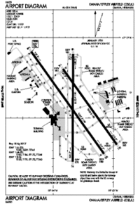
FAA airport diagram IATA: OMA – ICAO: KOMA – FAA LID: OMA Location of the Airport in Omaha, Nebraska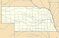
 OMA
OMASummary Airport type Public Operator Omaha Airport Authority Serves Greater Omaha, Nebraska Elevation AMSL 983 ft / 300 m Coordinates 41°18.12′N 95°53.62′W / 41.302°N 95.89367°W Website Runways Direction Length Surface ft m 14R/32L 9,502 2,896 Asphalt/Concrete 14L/32R 8,500 2,591 Concrete 18/36 8,153 2,485 Asphalt/Concrete Statistics (2009, 2010) Passengers (2010) 4,287,428 Aircraft operations (2009) 111,155 Cargo in pounds (2009) 102,149,802 Mail in pounds (2009) 54,305,909 Sources: FAA[1] and airport web site[2] Eppley Airfield (IATA: OMA, ICAO: KOMA, FAA LID: OMA) is a medium hub primary airport located three miles (5 km) northeast of the central business district of Omaha, a city in Douglas County, Nebraska, United States. It is the largest airport in the state of Nebraska. In addition to the Omaha-Council Bluffs metropolitan area, Eppley Airfield serves communities throughout eastern Nebraska, western Iowa, northern Kansas, Missouri, and South Dakota.
The airport is named for Eugene C. Eppley, the Omaha Eppley Hotel magnate, from whose estate $1 million was used to convert the Omaha Municipal Airport into a jet port in 1959/1960.[3]
The airport occupies 2,650 acres (1,070 ha) and handles about 397 commercial flights a week.[when?] The airport terminal building has two concourses consisting of 20 gates. Midwest Airlines established a focus city at Eppley Airfield, which has expanded since that airline's merger with Frontier Airlines. As of September 2011, all regularly scheduled flights from Eppley Airfield terminate within the United States. The airport handled more than 4.2 million passengers in 2010. Southwest Airlines is the largest carrier, handling approximately 28 percent of passengers; United Airlines/Continental Airlines is the second-largest carrier, handling approximately 23 percent of passengers.[2] The airport is served by MAT bus #16.
Contents
Location
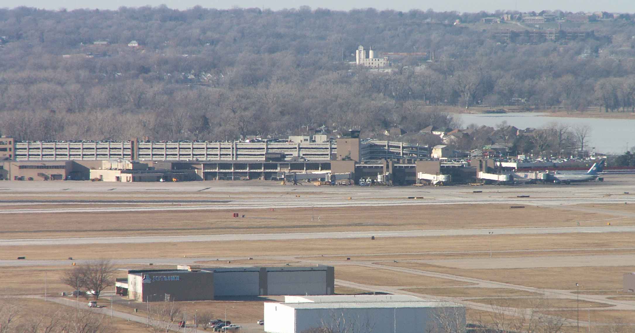
 Eppley Airfield terminal in Omaha. The houses immediately behind are in Carter Lake, Iowa (with Carter Lake visible to the right). The bluffs are in Omaha.
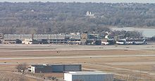
 View of Eppley Airfield and Downtown Omaha
 Eppley on June 16, 2011 during the 2011 Missouri River floods
The airport is located northeast of downtown Omaha in east Omaha. Although the airport is in Nebraska and on the west side of the Missouri River, through a geographic oddity it is surrounded on the east, west and south by the state of Iowa: the Missouri River formerly formed an oxbow immediately west of the land that became Eppley Airfield. The river cut off the oxbow during an 1877 flood, leaving behind Carter Lake on a portion of its former course; the Supreme Court ruled in 1893 that though the land cut off by the river's changed route now lay west of the Missouri, it remained part of Iowa. This land eventually became the city of Carter Lake, Iowa.
History
On August 6, 1966, Braniff Airways Flight 250 left Kansas City Downtown Airport headed for Eppley and crashed near Falls City, Nebraska, killing all 42 on board. The flight was waiting for weather to clear in Omaha before descending when violent turbulence compromised the structural integrity of the plane.
Several films have used Eppley for a few scenes including the 2002 feature film About Schmidt which included scenes filmed inside and outside the terminal building, and the 2009 feature film Up in the Air which made use of the south end of the terminal building during filming.
Airlines and destinations
Eppley Airfield has two passenger concourses: Concourse A (gates A1-A10) and Concourse B (gates B11-B20).
Airlines Destinations Concourse American Airlines Dallas/Fort Worth A American Eagle Chicago-O'Hare A Continental Airlines Houston-Intercontinental B Continental Express operated by ExpressJet Airlines Houston-Intercontinental, Newark B Delta Air Lines Atlanta, Minneapolis/St. Paul A Delta Connection operated by Atlantic Southeast Airlines Atlanta, Detroit, Memphis, Minneapolis/St. Paul A Delta Connection operated by Chautauqua Airlines Memphis A Delta Connection operated by Comair Cincinnati/Northern Kentucky, New York-LaGuardia A Delta Connection operated by Compass Airlines Atlanta, Minneapolis/St. Paul, Washington-National A Delta Connection operated by Mesaba Airlines Memphis, Minneapolis/St. Paul, Salt Lake City A Delta Connection operated by Pinnacle Airlines Atlanta, Detroit A Delta Connection operated by Shuttle America Detroit A Delta Connection operated by SkyWest Airlines Minneapolis/St. Paul, Salt Lake City A Frontier Airlines Denver A Frontier Airlines operated by Republic Airlines Denver, Los Angeles [begins February 14], San Diego [begins January 16], Washington-National
Seasonal: Orlando, St. Petersburg/Clearwater [begins January 16], Tampa [begins December 15]A Frontier Express operated by Chautauqua Airlines Milwaukee A Southwest Airlines Chicago-Midway, Denver, Las Vegas, Phoenix, St. Louis
Seasonal: OrlandoB United Airlines Chicago-O'Hare, Denver B United Express operated by ExpressJet Airlines Chicago-O'Hare, Denver B United Express operated by GoJet Airlines Chicago-O'Hare, Denver B United Express operated by Shuttle America Chicago-O'Hare, Denver B United Express operated by SkyWest Airlines Chicago-O'Hare, Denver, Houston-Intercontinental B US Airways Phoenix B US Airways Express operated by Mesa Airlines Phoenix B Top destinations
Busiest Domestic Routes from OMA (August 2010 - July 2011)[4] Rank City Passengers Carriers 1  Denver, CO
377,000 Frontier, Southwest, United 2  Chicago, IL (ORD)
212,000 American, United 3 Chicago, IL (MDW)172,000 Southwest 4  Dallas/Fort Worth, TX
172,000 American 5  Phoenix, AZ
163,000 Southwest, US Airways 6  Minneapolis, MN
136,000 Delta 7  Atlanta, GA
114,000 Delta 8 Houston, TX104,000 Continental 9  Las Vegas, NV
99,000 Southwest 10  St. Louis, MO
88,000 Southwest References
- ^ FAA Airport Master Record for OMA (Form 5010 PDF), effective 2007-10-25
- ^ a b Eppley Airfield, official web site
- ^ Eppley Grant of $1 Million Gives Omaha Jet Field - Lincoln Evening Journal, 1959-12-31
- ^ http://www.transtats.bts.gov/airports.asp?pn=1&Airport=OMA&Airport_Name=Omaha,%20NE:%20Eppley%20Airfield&carrier=FACTS
External links
- Eppley Airfield, official site
- Eppley Airport Guide on Omaha.net
- FAA Airport Diagram (PDF), effective 20 October 2011
- FAA Terminal Procedures for OMA, effective 20 October 2011
- Resources for this airport:
- AirNav airport information for KOMA
- ASN accident history for OMA
- FlightAware airport information and live flight tracker
- NOAA/NWS latest weather observations
- SkyVector aeronautical chart for KOMA
- FAA current OMA delay information
Transportation in Omaha Interstate Highways Freeways Other state routes Airports Public Transit Waterways Other Trails in Omaha · Automobile RowRelated templates: Boulevards • Railroads • Bridges • Streetcars • Streets • ExpresswaysCategories:- Transportation in Omaha, Nebraska
- Landmarks in North Omaha, Nebraska
- Airports in Nebraska
- Buildings and structures in Omaha, Nebraska


Wikimedia Foundation. 2010.