- Oxbow lake
-
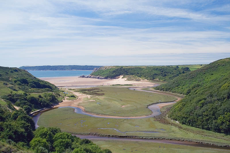
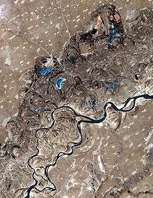 Songhua River, northeast China. Swirls and curves, showing paths the river once took, as well as oxbow lakes, are easily seen in this satellite photo.
An oxbow lake is a U-shaped body of water formed when a wide meander from the main stem of a river is cut off to create a lake. This landform is called an oxbow lake for the distinctive curved shape, named after part of a yoke for oxen. In Australia, an oxbow lake is called a billabong, derived from an indigenous language. The word "oxbow" can also refer to a U-shaped bend in a river or stream, whether or not it is cut off from the main stream.[1][2]
An oxbow lake is formed when a river creates a meander, due to the river's eroding the bank through hydraulic action and abrasion/corrosion. After a long period of time, the meander becomes very curved, and eventually the neck of the meander will touch the opposite side and the river will cut through the neck, cutting off the meander to form the oxbow lake.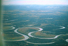
When a river reaches a low-lying plain, often in its final course to the sea or a lake, it meanders widely. In the vicinity of a river bend, deposition occurs on the convex bank (the bank with the smaller radius). In contrast, both lateral erosion and undercutting occur on the cut bank or concave bank (the bank with the greater radius.) Continuous deposition on the convex bank and erosion of the concave bank of a meandering river cause the formation of a very pronounced meander with two concave banks getting closer. The narrow neck of land between the two neighboring concave banks is finally cut through, either by lateral erosion of the two concave banks or by the strong currents of a flood. When this happens, a new straighter river channel is created and an abandoned meander loop, called a cutoff, is formed. When deposition finally seals off the cutoff from the river channel, an oxbow lake is formed. This process can occur over a time scale from a few years to several decades and may sometimes become essentially static.
Gathering of erosion products near the concave bank and transporting them to the convex bank is the work of the secondary flow across the floor of the river in the vicinity of a river bend. The process of deposition of silt, sand and gravel on the convex bank is clearly illustrated in point bars.[3]
River flood plains containing rivers with a highly sinuous platform will be populated by longer oxbow lakes than those with low sinuosity. This is because rivers with high sinuosity will have larger meanders and greater opportunity for longer lakes to form. Rivers with lower sinuosity are characterized by fewer cutoffs and shorter oxbow lakes due to the shorter distance of their meanders.[4]
The effect of the secondary flow can be demonstrated using a circular bowl. Partly fill the bowl with water and sprinkle dense particles such as sand or rice into the bowl. Set the water into circular motion with one hand or a spoon. The dense particles will quickly be swept into a neat pile in the center of the bowl. This is the mechanism that leads to the formation of point bars and contributes to the formation of oxbow lakes. The primary flow of water in the bowl is circular and the streamlines are concentric with the side of the bowl. However, the secondary flow of the boundary layer across the floor of the bowl is inward toward the center. The primary flow might be expected to fling the dense particles to the perimeter of the bowl, but instead the secondary flow sweeps the particles toward the center.
 Animation of the formation of an oxbow lake
The curved path of a river around a bend causes the surface of the water to be slightly higher on the outside of the river bend than on the inside. As a result, at any elevation within the river the water pressure is slightly greater near the outside of the river bend than on the inside. There is a pressure gradient toward the convex bank which provides the centripetal force necessary for each parcel of water to follow its curved path. The boundary layer flowing along the floor of the river is not moving fast enough to balance the pressure gradient laterally across the river. It responds to this pressure gradient and its velocity is partly downstream and partly across the river toward the convex bank.[3][5] As it flows along the floor of the river, it sweeps loose material toward the convex bank. This flow of the boundary layer is significantly different from the speed and direction of the primary flow of the river, and is part of the river's secondary flow.
When a fluid follows a curved path, such as around a circular bowl, around a bend in a river or in a tropical cyclone, the flow is described as vortex flow: the fastest speed occurs where the radius is smallest, and the slowest speed occurs where the radius is greatest. The higher fluid pressure and slower speed where the radius is greater, and the lower pressure and faster speed where the radius is smaller, are all consistent with Bernoulli's principle.
Contents
Examples

The Reelfoot Lake in west Tennessee is an oxbow lake formed when the Mississippi River changed course following the New Madrid earthquake of 1811–1812. There are many oxbow lakes alongside the Mississippi River and its tributaries. The largest oxbow lake in North America, Lake Chicot (located near Lake Village, Arkansas), was originally part of the Mississippi River.
The Oxbow (Connecticut River), a 2.5-mile (4.0 km) bend in the Connecticut River, is disconnected at one end.
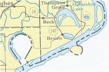
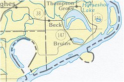
The town of Horseshoe Lake, Arkansas is named after the horseshoe-shaped oxbow lake on which it is located.
Cuckmere Haven in Sussex, England contains a widely meandering river with many oxbow lakes, often referred to in physical geography textbooks.
Kanwar Lake Bird Sanctuary, India contains rare and endangered migratory birds and is one of Asia's largest oxbow lakes.
Carter Lake, Iowa was created after severe flooding in 1877 led to the river shifting approximately 1.25 mi to the southeast.
Artificial oxbow lakes
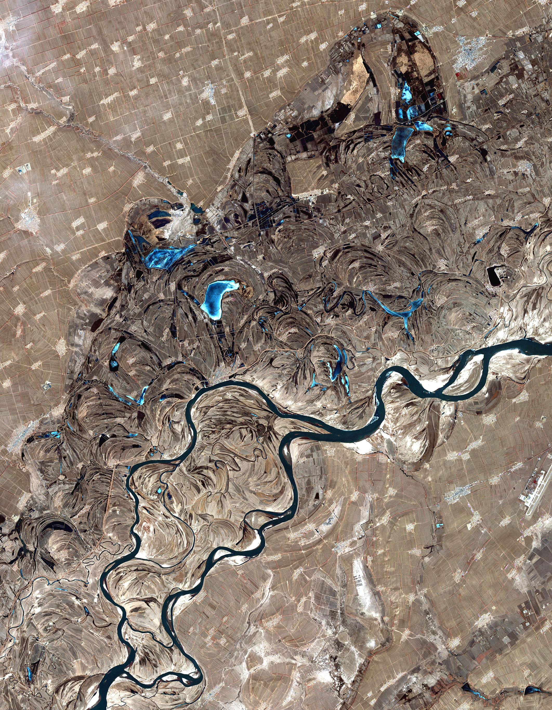
 A Horseshoe or oxbow lake near Hughes, Arkansas, USA.
The bulges in the border reflect changes in the course of the river; when the river shifted its course and cut off the former channel, the border did not change.Oxbow lakes may be formed when a river channel is straightened artificially to improve navigation or for flood alleviation. This occurred notably on the upper Rhine in Germany in the nineteenth century.[6]
An example of an entirely artificial waterway with oxbows is the Oxford Canal in England. When originally constructed, it had a very meandering course, following the contours of the land, but the northern part of the canal was straightened out between 1829 and 1834. The work reduced its length from 91 to 77 and a half miles (approximately) and left a number of oxbow-shaped sections isolated from the new course.[7]
See also
References
- ^ "Oxbow". Oxford English Dictionary. http://www.askoxford.com/concise_oed/oxbow?view=uk. Retrieved 2009-10-27.
- ^ "Oxbow". Merriam–Webster. http://www.m-w.com/cgi-bin/dictionary?book=Dictionary&va=oxbow. Retrieved 2009-10-27.
- ^ a b Hickin, Edward J. (2002). "Meandering Channels". In Middleton, Gerard V.. Encyclopedia of Sediments and Sedimentary Rocks. New York: Springer. p. 432. ISBN 1402008724.
- ^ Constantine, & Thomas, Dunne. (2008). "Meander cutoff and the controls on the production of oxbow lakes", Geology, 36(1)
- ^ "Secondary circulation in a region of flow curvature: Relationship with tidal forcing and river discharge". Journal of Geophysical Research - Oceans. 2002. http://www.agu.org/pubs/crossref/2002/2001JC001082.shtml. Retrieved 2009-10-27.
- ^ Zinke, Alexander (December 17, 2000). "The New Management of Rivers and Wetlands in Central Europe". Zinke Environmental Consulting. http://www.zinke.at/Japansymp.htm. Retrieved 2009-10-27.
- ^ Boughey, Joseph (1994). Hadfield's British Canals. Sutton Publishing. ISBN 0750918403.
External links
River morphology Large-scale features Alluvial rivers Meander • Meander cutoff • Point bar • Cut bank • Riffle • Stream pool • Braided river • Bar (river morphology) • Anabranch • River bifurcation • River channel migration • Oxbow lake • Floodplain • Riparian corridor • Avulsion (river) • Mouth bar • Thalweg • Channel patternBedrock river Bedforms Regional processes Mechanics Playfair's Law • Hack's law • Sediment transport • Water erosion • Deposition (geology) • Exner equationCategories:- Fluvial landforms
- Lakes
- Oxbow lakes
- Rivers


Wikimedia Foundation. 2010.