- Cuckmere Haven
-
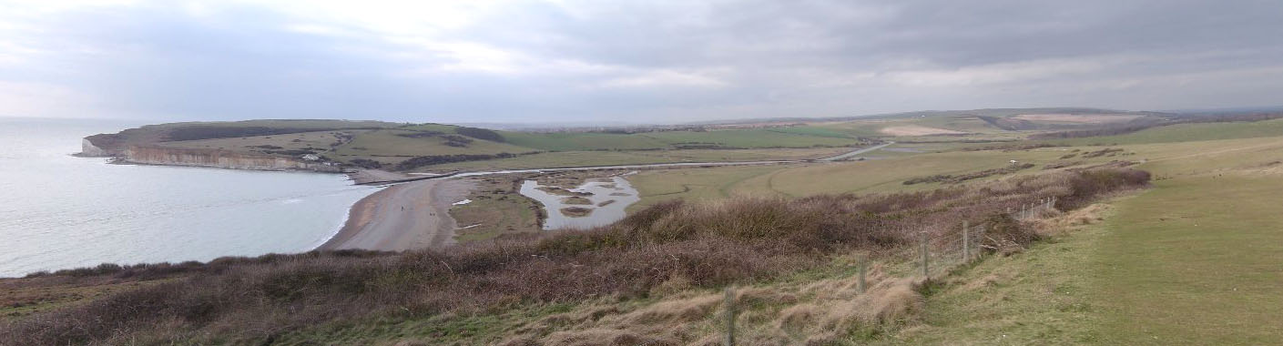
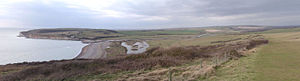 Looking West over Cuckmere Haven
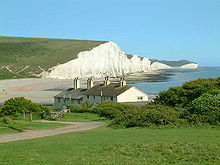 The Seven Sisters cliffs and the coastguard cottages, from Seaford Head showing Cuckmere Haven (looking East).
Cuckmere Haven (also known as the Cuckmere Estuary) is an area of flood plains in Sussex, England where the river Cuckmere meets the English Channel between Eastbourne and Seaford. The river is an example of a meandering river, and contains several oxbow lakes. It is a popular tourist destination with an estimated 350,000 visitors per year, where they can engage in long walks, or water activities on the river. The beach at Cuckmere Haven is next to the famous chalk cliffs, the Seven Sisters.
At low tide, one can spot ironwork in the sea close to the river mouth. This is the wreck of the Polynesia, a German sailing ship that ran aground in April 1890 west of Beachy Head; it was laden with a cargo of sodium nitrate.
Contents
History
 World War II defences at Cuckmere Haven
The beach was commonly used by smugglers in the 16th, 17th and 18th centuries. For example, in 1783 two gangs of smugglers (each numbering 200 or 300) overcame officers of the law by weight of numbers and carried away a large quantity of goods.
In the Second World War, the site was studied by the Luftwaffe as they flew missions to identify potential landing sites for the invasion of the UK mainland. As a result the British constructed a series of counter-landing defences, of which numerous pillboxes, anti-tank obstacles, ditches and tank traps survive.[1] Admiralty scaffolding blocked the inlet, but is now gone.[1] Cuckmere Haven featured heavily in the war effort: at night lights were placed to confuse bombers into thinking they were above Newhaven and an airfield was set up further inland.[2] In addition to the permanent land-based constructions, the river was heavily mined.[1]
The East Sussex Transport and Trading Company extracted gravel from the beach at Cuckmere Haven. They transported the material to the road at Exceat on a 2'-gauge tramway a mile long, established in the early 1930s and closed in 1964. The tramway began in what is now the car park on the southern side of the main road. The footpath to Cuckmere Haven (east of the river) follows the line of the tramway.[3]
In popular culture
- The beach at Cuckmere Haven was used for the opening scene in Kevin Costner's Robin Hood: Prince of Thieves.
- The Seven Sisters cliff face was briefly featured in the Harry Potter film Harry Potter and the Goblet of Fire.
- The beach was featured in the film Atonement (2007): a postcard of the coastguard cottage overlooking the beach was a central element of the plot, with Robbie Turner focusing on it as the idyll where he and Cecilia Tallis would retire after World War II. .
- The cliffhanger of the TV sitcom Green Wing Series 1 was filmed at Cuckmere Haven.
- The beach and house was the location of Cheryl Cole's video for The Flood
- The beach was used in an episode of Foyle's War.
Settlements within the park
Two hamlets, Exceat and Foxhole, are in the park, along with a small group of cottages on the cliff edge (known as the Coastguard cottages) - these are mostly kept as holiday homes except for one hardy resident who lives there all year round. Next to the Friston Forest car park, Exceat is a group of farm buildings with facilities and a café. There is also a tiny old shepherd's caravan. The name "Exceat" derives from the old English word for "exit"; the hamlet was an exit for people sailing out to the Channel. Foxhole is made up of another group of agricultural buildings, with a large pond at the centre. The two houses are home to the Seven Sisters Country Park rangers, and one barn has been converted to a camping barn, with an adjacent field for camping. This is known as Foxhole Campsite, and is useful for South Downs Way walkers.
Wildlife and ecosystem
Cuckmere Haven is home to a large variety of wildlife, and has a rich ecosystem. Domestic sheep and cattle graze the grass, keeping the fields at a constant vegetation level. Woodpigeons and rooks pick at the stubble and aquatic birds such as oystercatchers forage in the water meadows. The result is a fertile area of land providing varied habitats. The beaches are made up of shingle and, right by the sea, rockpools. Chalk is eroded off the cliffs but not much ends up on the beach. Driftwood and rubbish end up on the beach but do not seem to pollute the environment and do not spoil the view of the beach.
Reptiles
- Adder (snake)
- Grass snake
- Slow worm
Mammals
- Badger
- Rabbits live in the sandy banks by the main path
- Red fox
- Domestic cattle (largely young bullocks) and sheep, mainly owned by Foxhole Farm, graze all round the park. Visitors must keep dogs on leads.
Birds
- Sea gulls
- Black-headed gull
- Brent goose
- Canada goose
- Carrion crow
- Common sandpiper
- Fulmars nest on the cliffs in summer; although not as common as the herring gulls, they can easily be spotted from the beach.
- Green woodpecker
- Grey heron
- Grey wagtail
- Greylag goose
- Herring gull
- Jackdaw
- Kestrel
- Little egrets had their first stronghold here at Cuckmere Haven and nest on the marshy area by the beach with the herons, with which they often forage.
- Little grebe
- Meadow pipit
- Oystercatcher
- Pied wagtail
- Common pochard
- Common redshank
- Reed bunting
- Ringed plover
- Rook
- Sand martins nest in the burrows they build in the sand banks by the path in summer. Rabbits take over the burrows in the martins' absence and have to be chased out when the birds return in spring.
- Common shelduck
- Short-eared Owl
- Skylarks tend to stay on the hills to the east of the river, where they nest in the long grass and rise up to sing.
- Stonechat
- Swallow
- Wigeon
- Woodpigeon
References
Notes
General references
- Foot, William (2006). Beaches, fields, streets, and hills ... the anti-invasion landscapes of England, 1940. Council for British Archaeology. ISBN 1-902771-53-2.
External links
Categories:- Geography of East Sussex
- Nature Conservation Review sites
- Populated coastal places in East Sussex


Wikimedia Foundation. 2010.