- Juneau, Alaska
-
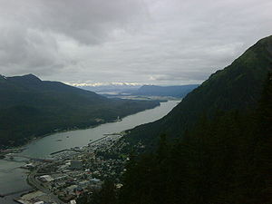
City and Borough of Juneau — City and Borough — Gastineau Channel with downtown Juneau 
Flag
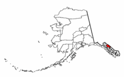
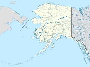
SealLocation of Juneau City and Borough, Alaska Location of Juneau in the state of Alaska, United States Coordinates: 58°26′40″N 134°13′47″W / 58.44444°N 134.22972°WCoordinates: 58°26′40″N 134°13′47″W / 58.44444°N 134.22972°W Country United States U.S. State Alaska Named 1881 Government - Mayor Bruce Botelho Area - City and Borough 3,255.0 sq mi (8,430.4 km2) - Land 2,715.7 sq mi (7,036.1 km2) - Water 539.3 sq mi (1,394.3 km2) - Urban 12 sq mi (31.1 km2) Elevation 56 ft (17 m) Population (2010) - City and Borough 31,275 - Density 11.3/sq mi (4.4/km2) - Urban 17,311 Time zone AKST (UTC-9) - Summer (DST) AKDT (UTC-8) Zip code 99801 Area code(s) 907 FIPS code 02-36400 GNIS feature ID 1404263 Website www.juneau.org The City and Borough of Juneau (
 /ˈdʒuːnoʊ/) is a unified municipality located on the Gastineau Channel in the panhandle of the U.S. state of Alaska. It has been the capital of Alaska since 1906, when the government of the then-District of Alaska was moved from Sitka as dictated by the U.S. Congress in 1900. The municipality unified in 1970 when the city of Juneau merged with the city of Douglas and the surrounding Greater Juneau Borough to form the current home rule municipality.
The area of Juneau is larger than that of Rhode Island and Delaware individually and almost as large as the two states combined. Downtown Juneau 58°18′07″N 134°25′11″W / 58.30194°N 134.41972°W is nestled at the base of Mount Juneau and across the channel from Douglas Island. As of the 2010 census, the City and Borough had a population of 31,275.
Juneau is named after gold prospector Joe Juneau, though the place was for a time called Rockwell and then Harrisburg (after Juneau's co-prospector, Richard Harris). The Tlingit name of the town is Dzántik'i Héeni ("river where the flounders gather"), and Auke Bay just north of Juneau proper is called Aak'w ("little lake") in Tlingit. The Taku River, just south of Juneau, was named after the cold t'aakh wind, which occasionally blows down from the mountains.
Downtown Juneau sits at sea level, with tides averaging 16 feet (5 m), below steep mountains about 3,500 feet (1,100 m) to 4,000 feet (1,200 m) high. Atop these mountains is the Juneau Icefield, a large ice mass from which about 30 glaciers flow; two of these, the Mendenhall Glacier and the Lemon Creek Glacier, are visible from the local road system; the Mendenhall glacier has been generally retreating; its front face is declining both in width and height.
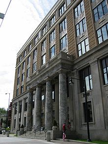
The Alaska State Capitol in downtown Juneau was originally built as the Federal and Territorial Building in 1931. Prior to statehood, it housed federal government offices, the federal courthouse and a post office. It also housed the territorial legislature and many other territorial offices, including that of the governor. Today, it is still the home of the state legislature and the offices of the governor and lieutenant governor. Other executive branch offices have largely moved elsewhere, in Juneau or elsewhere in the state, in the ongoing battle between branches for space in the building, as well as the decades-long capital move issue. Recent discussion has been focused between relocating the seat of state government outside of Juneau and building a new capitol building in Juneau. Neither position has advanced very far. The Alaska Committee, a local community advocacy group, has led efforts to thus far keep the capital in Juneau.
Contents
History
Long before European settlement in the Americas, the Gastineau Channel was a favorite fishing ground for local Tlingit Indians, known then as the Auke and Taku tribes, who had inhabited the surrounding area for thousands of years. The native cultures are rich with artistic traditions including carving, weaving, orating, singing and dancing, and Juneau has become a major social center for the Tlingit, Haida, and Tsimshian of Southeast Alaska.
The first European to see the Juneau area was Joseph Whidbey, master of the Discovery during George Vancouver’s 1791-95 expedition, who explored the region in July–August 1794. Early in August he saw the length of Gastineau Channel from the south, noting a small island in mid-channel. He later saw the length of the channel again, this time from the west. He said it was unnavigable, being filled with ice.[1]
In 1880, Sitka mining engineer George Pilz offered a reward to any local chief who could lead him to gold-bearing ore. Chief Kowee arrived with some ore and several prospectors were sent to investigate. On their first trip, to Gold Creek, they found deposits of little interest. However, at Chief Kowee's urging Pilz sent Joe Juneau and Richard Harris back to the Gastineau Channel, directing them to Snow Slide Gulch (the head of Gold Creek) where they found nuggets "as large as peas and beans", in Harris' words.
On October 18, 1880, the two men marked a 160-acre (650,000 m2) town site where soon a mining camp appeared. Within a year, the camp became a small town, the first to be founded after Alaska's purchase by the United States.
The town was originally called Harrisburg, after Richard Harris; some time later, its name was changed to Rockwell, after Lt. Com. Charles Rockwell. In 1881, the miners met and renamed the town Juneau, after Joe Juneau. In 1906, after the diminution of the whaling and fur trade, Sitka, the original capital of Alaska, declined in importance and the seat of government was moved to Juneau. Juneau was the largest city in Alaska during the inter-war years, passing Fairbanks in the 1920 census and displaced by Anchorage in 1950.
In 1911, the United States Congress authorized funds for the building of a capitol building for the Alaska Territory. Because of World War I, construction was delayed, also there were difficulties purchasing the necessary land. Local citizens of Juneau donated some of the required funds, and construction began on September 8, 1929. Construction of the capitol took less than two years, and the building was dedicated as the Federal and Territorial Building on February 14, 1931. The design of the building was drawn up by Treasury Department architects in the Art Deco architectural style. The building was originally used by the federal government in order to house the federal courthouse and post office. Once Alaska gained statehood in 1959, the building has been used by the state government.
The Alaska Governor's Mansion was commissioned under the Public Building Act in 1910. The mansion was designed by James Knox Taylor in the in the old Federal Style. The construction took two years and was completed in 1912. The territorial governor at that time was the first governor to inhabit the mansion, and he held the first open house to the citizens on January 1, 1913. The area of the mansion is 14,400 square feet (1,340 m2). This is where the governor resides when he or she is in Juneau for official business. The mansion contains ten bathrooms, six bedrooms, and eight fireplaces. In June 1923, President Warren G. Harding became the first president to visit Alaska. During his trip, Harding visited the Governor's Mansion while Governor Scott Bone, who was appointed by Harding, was in office. Harding spoke from the porch of the Governor's Mansion explaining his policies and meeting the ordinary people.
Robert Atwood, then publisher of the Anchorage Times and an Anchorage 'booster,' was an early leader in capital move efforts—efforts which many in Juneau and Fairbanks resisted. One provision required the new capital to be at least 30 miles (48 km) from Anchorage and Fairbanks, to prevent either city from having undue influence; in the end Juneau remained the capital. In the 1970s, voters passed a plan to move the capital to Willow, a town 70 miles (110 km) north of Anchorage. But pro-Juneau people there and in Fairbanks got voters to also approve a measure (the FRANK Initiative) requiring voter approval of all bondable construction costs before building could begin. Alaskans later voted against spending the estimated $900 million. A 1984 "ultimate" capital-move vote also failed, as did a 1996 vote.
Alaskans thus several times voted on moving their capital, but Juneau remains the capital.[2] Once Alaska was granted statehood in 1959, Juneau grew with the growth of state government. Growth accelerated remarkably after the construction of the Alaska Pipeline in 1977, the state budget being flush with oil revenues; Juneau expanded for a time due to growth in state government jobs, but that growth slowed considerably in the 1980s.[3] The state demographer expects the borough to grow very slowly over the next twenty years.[4] Cruise ship tourism rocketed upward from about 230,000 passengers in 1990 to nearly 1,000,000 in 2006 as cruise lines built more and larger ships—even 'mega-ships', sailing to Juneau seven days a week instead of six, over a longer season, but this primarily summer industry provides few year-round jobs. Its population rank in 2000 was second in the state, closely ahead of Fairbanks; recent estimates have Juneau falling back to third, as it was in the 1960–90 counts.
In 2010, the city was recognized as part of the "Playful City USA" initiative by KaBOOM! created to honor cities that ensure that their children have great places to play.[5]
Juneau is larger in area than the state of Delaware and was, for many years, the country's largest city by area. Juneau continues to be the only U.S. state capital located on an international border: it is bordered on the east by Canada. It is the U.S. state capital whose namesake was most recently alive: Joe Juneau died in 1899, a year after Otto von Bismarck (North Dakota).
Geography
According to the United States Census Bureau, the borough has a total area of 3,255.0 square miles (8,430 km2), making it the third-largest municipality in the United States by area (the largest is Yakutat City and Borough, Alaska). 2,716.7 square miles (7,036 km2) of it is land and 538.3 square miles (1,394 km2) of it (16.54%) is water.
Central (downtown) Juneau is located at 58°18′07″N 134°25′11″W / 58.30194°N 134.41972°W.[6] The City and Borough of Juneau includes Douglas Island, a tidal island located to the west of mainland Juneau. Access to and from Douglas Island is made possible by crossing the Juneau-Douglas Bridge.
Adjacent boroughs and census areas
- Haines Borough, Alaska - northwest, west
- Hoonah-Angoon Census Area, Alaska - south, southwest
Border area
Juneau, Alaska, shares its eastern border with the Canadian province of British Columbia. It is the only U.S. state capital to border another country. Carson City, Nevada and Trenton, New Jersey are the only state capitals which border another state.
- Stikine Region, British Columbia - northeast, east

Haines Borough Stikine Region, British Columbia, Canada Stikine Region, British Columbia, Canada 
Haines Borough 
Stikine Region, British Columbia, Canada  Juneau, Alaska

Hoonah-Angoon Census Area Hoonah-Angoon Census Area National protected areas
- Tongass National Forest (part)
- Admiralty Island National Monument (part)
- Kootznoowoo Wilderness (part)
- Tracy Arm-Fords Terror Wilderness (part)
- Admiralty Island National Monument (part)
Climate
Juneau features a cool temperate climate. The city has a climate that is milder than its latitude may suggest, due to the influence of the Pacific Ocean. Winters are moist, long but only slightly cold: temperatures drop to 20 °F (−6.7 °C) in January, and highs are frequently above freezing. Spring, summer, and fall are cool to mild, with highs peaking in July at 65 °F (18.3 °C). Snowfall averages 84 inches (213 cm) and occurs chiefly from November to March. Precipitation is adequate year-round, averaging 58.3 inches (1,480 mm) at the airport, but ranging from 55 inches (1,400 mm) to 90 inches (2,290 mm), depending on location.[7] The spring months are the driest while September and October are the wettest.
Climate data for Juneau, Alaska (Juneau Int'l) Month Jan Feb Mar Apr May Jun Jul Aug Sep Oct Nov Dec Year Average high °F (°C) 30.6
(−0.8)34.3
(1.3)39.5
(4.2)48.2
(9.0)55.7
(13.2)61.6
(16.4)64.4
(18.0)63.2
(17.3)56.1
(13.4)46.9
(8.3)37.6
(3.1)33.0
(0.6)47.6 Average low °F (°C) 20.7
(−6.3)23.5
(−4.7)27.8
(−2.3)33.4
(0.8)40.1
(4.5)46.1
(7.8)49.2
(9.6)48.3
(9.1)43.8
(6.6)37.7
(3.2)28.9
(−1.7)24.4
(−4.2)35.3 Precipitation inches (mm) 4.81
(122.2)4.02
(102.1)3.51
(89.2)2.96
(75.2)3.48
(88.4)3.36
(85.3)4.14
(105.2)5.37
(136.4)7.54
(191.5)8.30
(210.8)5.43
(137.9)5.41
(137.4)58.33
(1,481.6)Snowfall inches (cm) 25.4
(64.5)16.2
(41.1)10.1
(25.7)1.0
(2.5)0
(0)0
(0)0
(0)0
(0)0
(0)1.1
(2.8)11.7
(29.7)18.6
(47.2)84.1
(213.6)Avg. precipitation days (≥ 0.01 in) 19.4 16.2 18.8 17.5 17.1 15.9 16.7 18.1 21.1 23.9 20.3 20.9 225.9 Avg. snowy days (≥ 0.1 in) 9.8 7.1 5.9 1.4 0 0 0 0 0 .7 4.9 9.3 39.1 Sunshine hours 80.6 90.4 136.4 183.0 232.5 189.0 182.9 161.2 111.0 65.1 60.0 40.3 1,500.0 Source: NOAA,[8] HKO [9] Demographics
Historical populations Census Pop. %± 1890 1,253 — 1900 1,864 48.8% 1910 1,644 −11.8% 1920 3,058 86.0% 1930 4,043 32.2% 1940 5,729 41.7% 1950 5,956 4.0% 1960 6,797 14.1% 1970 6,050 −11.0% 1980 19,528 222.8% 1990 26,751 37.0% 2000 30,711 14.8% 2010 31,275 1.8% source:[10][11] As of the census[12] of 2000, there were 30,700 people, 11,500 households, and 7,600 families residing in the city/borough. The population density was 11.3/square mile (4.4/km²). There were 12,300 housing units at an average density of 4.5 per square mile (1.7/km²). The racial makeup of the city/borough was 74.8% White, 0.8% African American, 11.4% Native American, 4.7% Asian, 0.4% Pacific Islander, and 1.1% from other races, and 6.9% from two or more races. 3.4% of the population were Hispanic or Latino of any race. 15.1% reported speaking Tlingit at home, 5.1% Inupiaq, 2.6% Tagalog, and 2.4% Spanish.[13]
There were 11,543 households out of which 36.7% had children under the age of 18 living with them, 51.2% were married couples living together, 10.5% had a female householder with no husband present, and 33.8% were non-families. 24.4% of all households were made up of individuals and 4.3% had someone living alone who was 65 years of age or older. The average household size was 2.60 and the average family size was 3.10.
In the city/borough the population was spread out with 27.4% under the age of 18, 8.1% from 18 to 24, 32.8% from 25 to 44, 25.7% from 45 to 64, and 6.1% who were 65 years of age or older. The median age was 35 years. For every 100 females, there were 101.5 males. For every 100 females age 18 and over, there were 100.2 males.
The median income for a household in the city/borough was $62,034, and the median income for a family was $70,284. Males had a median income of $46,744 versus $33,168 for females. The per capita income for the city/borough was $26,719. 6.0% of the population and 3.7% of families were below the poverty line, including 6.7% of those under the age of 18 and 3.9% of those 65 and older.
Economy
As the capital of Alaska, the primary employer in Juneau, by a large margin, is government. This includes the federal government, state government, municipal government (which includes the local airport, hospital, harbors, and school district), as well as the University of Alaska Southeast. State government offices and their indirect economic impact compose approximately one-quarter of Juneau's economy.[14]
Another large contributor to the local economy, at least on a part-time basis, is the tourism industry. In 2005, the cruise ship industry was estimated to bring nearly one million visitors to Juneau for up to 11 hours at a time, between the months of May and September.[15] While cruise ships do provide an economic boost to segments of the economy, not all locals are appreciative. The Juneau Public Library, built atop a parking garage along South Franklin Street near the Red Dog Saloon, was designed to take advantage of the view of and across Gastineau Channel. This view is often blocked by docking cruise ships, which tower over the five-story structure. Bill Ray, who lived in Juneau from 1938 to 2000 and represented the community in the Alaska Legislature from 1965 to 1987, was rather blunt in expressing his disdain when he paid a return visit in 2003: "Juneau doesn't go forward. They've prostituted themselves to tourism. It looks like a poor man's Lahaina".[16]
The fishing industry is still a major part of the Juneau economy, while not the dominant player back in the days of the halibut schooner fleet. Juneau was recently the 49th most lucrative U.S. fisheries port by volume and 45th by value taking in 15 million pounds of fish and shellfish valued at 21.5 million dollars in 2004 according to the National Marine Fisheries Service. While the port of Juneau does comparatively little seafood processing to towns of this size in Alaska, there are hundreds of commercial fishing boats who sell their fish to plants in nearby Sitka, Hoonah, Petersburg and Ketchikan. The largest fleets operating from Juneau are the gillnet and troll salmon fleets. Juneau is also the home to many of the commercial fishing associations in Alaska, including the Alaska Trollers Association, United Fishermen of Alaska, United Southeast Alaska Gillnetters Association and the Southeast Alaska Seiners Association.
Real estate agencies, federally-funded highway construction, and mining are apparently still viable non-government local industries.
Juneau's only power utility is Alaska Electric Light & Power (AEL&P). Most of the electricity in the borough is generated at the Snettisham Hydroelectric facility in the southern end of the borough, accessible only by boat or plane. In April 2008, an avalanche destroyed three transmission towers, forcing AEL&P to generate almost all of the borough's electricity with diesel-powered generators.
Eaglecrest Ski Area is operated from late November through April each year and offers world class downhill skiing. While there are only 4 chairlifts, the terrain is fantastic, the lift lines are short and when there is a shortage of snow in the Cascades or the Rockies, one can find wealthy west coast skiiers migrating north to enjoy the slopes of Eaglecrest on Douglas Island, a mere 15 minute drive from downtown Juneau.
Wings of Alaska, an airline, has its headquarters in Juneau.[17]
Culture
Juneau is home to Perseverance Theatre, Alaska's only professional theater. The city hosts the annual Alaska Folk Festival and Juneau Jazz & Classics music festivals, and the biennial Celebration. The Juneau Symphony performs regularly. Downtown Juneau boasts dozens of art galleries, which participate in the monthly First Friday Gallery Walk and the enormously popular December Gallery Walk held in the first week of December. The Juneau Arts & Humanities Council coordinates events while fund-raising, distributing some grant money, and operating a gallery at its office in the Juneau Arts & Culture Center, 350 Whittier Street. On summer Friday evenings open-air music and dance performances are held at Marine Park. The University of Alaska Southeast Campus also offers lectures, concerts, and theater performances.
The Juneau Lyric Opera and Opera to Go are the two local opera companies. JLO produces operas in English and Italian and sponsors two annual choral workshop festivals, as well as the touring group the "3 Tenors from Juneau."
Some Juneau artists include violinists Linda and Paul Rosenthal, soprano Kathleen Wayne, bass John d'Armand, baritones Philippe Damerval and David Miller, tenors Jay Query, Brett Crawford and Dan Wayne, Rory Merritt Stitt, pianist Mary Watson, folk musician Buddy Tabor, playwright Robert Bruce "Bo" Anderson, and painters Rie Muñoz, David Woodie, Barbara Craver, Rob Roys, Elise Tomlinson, and Herb Bonnet. Alaska Native carver and painter James Schoppert. Photographer Ron Klein is a past president of the International Association of Panoramic Photographers.
Government
Two districts have been defined by the Assembly of the City and Borough of Juneau:
- District 1 precinct
- Downtown Juneau
- Salmon Creek
- Lemon Creek
- Switzer Creek
- Juneau International Airport
- Douglas Island
- District 2 precincts
- Mendenhall Valley
- Auke Bay
- Fritz Cove
- Lynn Canal
- Tee Harbor
Presidential Election Results for the City and Borough of Juneau 2004-2008 Year Democrat Republican 2008 64.4% 32.4% 2004 59.2% 37.3% Education
Primary and secondary schools
Juneau is served by the Juneau School District and includes the following schools:[19]
- Gastineau Elementary School
- Harborview Elementary School
- Riverbend Elementary School
- Mendenhall River Elementary School
- Glacier Valley Elementary School
- Auke Bay Elementary School
- Juneau Community Charter School
- Montessori Borealis School
- Dzantik'i Heeni Middle School
- Floyd Dryden Middle School
- Juneau-Douglas High School
- Thunder Mountain High School
- Yaaḵoosgé Daakahídi Alternative High School
- HomeBRIDGE (homeschooling program)
In addition, the following private schools also serve Juneau:
- (Glacier) Valley Baptist Academy
- Faith Community School
- Thunder Mountain Learning Center (Formerly Thunder Mountain Academy)
- Juneau Seventh-day Adventist Christian School
- Juneau Montessori School
Colleges and universities
Juneau is the home of the following institutes of higher education:
The University of Alaska Southeast is located within the Auke Bay community right along the Auke Lake. The Juneau-Douglas Community College, founded in 1956, and the Southeastern Senior College, established in 1972, were merged in 1980 forming the University of Alaska Juneau. The University was restructured as the University of Alaska Southeast to include the Ketchikan and Sitka campuses. The university offers both degrees and undergraduate and graduate studies. The University of Alaska Southeast is known for its research in regards to the Tongass National Forest and the Juneau Icefield.
Transportation
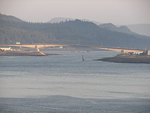 The Juneau-Douglas Bridge, connecting mainland Juneau with Douglas Island. The original bridge was built in 1935. The bridge shown here, which replaced the original, was completed in 1980.
Sea
Juneau is accessible only by sea or air. Cars and trucks are transported to and from Juneau by barge or ferry. The State-owned ferry is called the Alaska Marine Highway System (AMHS). Juneau is one of only five state capitals not served by an interstate highway. (Others are Dover, Delaware; Jefferson City, Missouri; Carson City, Nevada; and Pierre, South Dakota.) Local government operates a bus service under the name Capital Transit. There are also several taxicab companies, and tour buses used mainly for cruise ship visitors.
Air
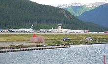
Juneau International Airport serves the city & borough of Juneau. Alaska Airlines is as of 2009 the sole commercial jet passenger operator. MarkAir and Western Airlines and its successor, Delta previously served Juneau. Alaska Airlines provides service to Anchorage and Sitka as well as to many small communities in the state. Seattle is a common destination for Juneau residents. Wings of Alaska, Alaska Seaplanes, and Air Excursions offer scheduled flights on smaller aircraft to villages in Southeast Alaska. Some air carriers provide U.S. mail service.
- List of airports in the City and Borough of Juneau
Roads
Avalanche hazards, steep slopes, cold weather and environmental protection concerns are factors that make road construction and maintenance difficult and costly.
The Juneau-Douglas Bridge connects Juneau mainland with Douglas Island.
Mendenhall Glacier
A very popular destination is Mendenhall Glacier. A bridge connects Douglas Island with the rest of Juneau, and there are about five places where roads end. Float planes and helicopters offer glacier tours in summer. Dog sled rides are often given to tourists landing on the glaciers or ice caps. Other companies offer boat rides. One of the signature places in Juneau is The Mount Roberts Tramway, an aerial tramway stretching from a station on the cruise ship docks to a point on the southwestern ridge of Mount Roberts.
Juneau Access Project
Juneau's roads remain separate from other roads in Alaska and in the Lower 48. Currently, fast car ferries connect Juneau with Haines and Skagway.[20] There are plans to connect Juneau to Haines and Skagway by road, but the State of Alaska Department of Transportation and Public Facilities announced in 2005 that the connection was to be provided partly by road, and partly by fast ferry.[21] A 51-mile (82 km) road would be built on east side of Lynn Canal to a new ferry terminal at the Katzehin River estuary.[20] A ferry would take cars from the terminal to Haines and Skagway, where the cars could then drive to the rest of North America.[20] In 2006, the project was estimated to cost $258 million, and in 2007, the estimate was increased to $350 million.[20] The Western Federal Lands Center estimates the project will cost $491 million.[20] As of 2009, $25 million has been spent on the project.[20]
Local opinions on constructing a road link to the outside world are mixed. Some residents see such a road as a much-needed link between Juneau and the rest of the world which will also provide great economic benefits to the city, while many other residents are concerned about environmental and social impacts.
Walking, Hiking, and Biking
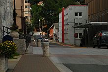
Residents walk, hike, or ride bicycles recreationally. A study has been conducted to make Juneau a more walkable area. The downtown area of Juneau has great sidewalks and the neighborhoods on the hill above downtown are easily accessible.
Media
Juneau's only daily newspaper, the Juneau Empire, is published Sunday through Friday, no Saturday edition. There is also a regional weekly newspaper, the Capital City Weekly. Juneau-Douglas High School has The Ego and the Alterego, a monthly magazine, and the University of Alaska Southeast has The Whalesong, a college newspaper.
- Radio
Additionally, the studios of CoastAlaska (a regional public radio station consortium), are located in Juneau. AP (the Associated Press), Anchorage news outlets, and other Alaska media entities, send reporters to Juneau during the annual Legislative session.
- Television
Juneau's major television affiliates are; KTOO (PBS), KATH-LP (NBC), and KJUD (ABC)/The CW on DT2. Fox and MyNetworkTV are only available on cable via their Anchorage affiliates.
The Juneau-Douglas High School also has a program with KTOO, airing one hour a week during the school year, produced entirely by students.
Sister cities
Juneau has 5 official sister cities.[22]
 Camiling, Philippines
 Whitehorse, Yukon, Canada
 Chiayi, Taiwan, Republic of China
 Vladivostok, Russia
 Mishan, Heilongjiang Province, People's Republic of China
See also
- Adair-Kennedy Memorial Park
- Auke Bay, Alaska
- Douglas, Alaska
- Evergreen Cemetery
- National Register of Historic Places listings in Juneau, Alaska
- Out the road (Juneau), a region of Juneau
- Thane, Alaska
Notes
- ^ Vancouver, George, and John Vancouver (1801; vols. I-VI). A voyage of discovery to the North Pacific ocean, and round the world. London: J. Stockdale. http://books.google.com/?id=qwol8bPaYxsC&printsec=frontcover#v=onepage&q&f=false.
- ^ http://www.gov.state.ak.us/ltgov/elections/capmove.htm
- ^ "CensusScope – Population Growth". http://www.censusscope.org/us/s2/c110/chart_popl.html. Retrieved November 15, 2005.
- ^ "Juneau's future demographic: Growing older". JuneauAlaska.com. http://juneaualaska.com/history/history_demograph.shtml. Retrieved 2005-11-15.
- ^ Juneau Named ‘Playful’ City, Only Honoree in Alaska. Juneau Empire, September 3, 2010. Retrieved 2010-11-15.
- ^ "US Gazetteer files: 2010, 2000, and 1990". United States Census Bureau. 2011-02-12. http://www.census.gov/geo/www/gazetteer/gazette.html. Retrieved 2011-04-23.
- ^ Weather - Tongass National Forest
- ^ "Climatography of the United States No. 20 1971-2000: JUNEAU INTL AP, AK" (PDF). National Oceanic and Atmospheric Administration. http://cdo.ncdc.noaa.gov/climatenormals/clim20/ak/504100.pdf. Retrieved 2010-05-21.
- ^ "Climatological Normals of Juneau". Hong Kong Observatory. http://www.weather.gov.hk/wxinfo/climat/world/eng/n_america/us/Juneau_e.htm. Retrieved 2010-05-21.
- ^ "Annual Estimates of the Resident Population for Incorporated Places in Alaska, Listed Alphabetically: April 1, 2000 to July 1, 2008" (CSV). 2008 Population Estimates. U.S. Census Bureau, Population Division. July 1, 2009. http://www.census.gov/popest/cities/tables/SUB-EST2008-04-02.csv. Retrieved July 27, 2009.
- ^ Moffatt, Riley. Population History of Western U.S. Cities & Towns, 1850-1990. Lanham: Scarecrow, 1996, 4.
- ^ "American FactFinder". United States Census Bureau. http://factfinder.census.gov. Retrieved 2008-01-31.
- ^ Language Map Data Center
- ^ The Associated Press. "Alaska capital move would devastate Juneau economy", Fairbanks Daily News-Miner. April 19, 2009. Accessed August 2, 2009.
- ^ "Cruise outlook for 2005 shows growth". http://www.juneauempire.com/stories/041005/loc_20050410003.shtml. Retrieved November 15, 2005.
- ^ "Memoirs of a longtime lawmaker – Bill Ray comes to Juneau to sign his new book, 'Liquor, Legislation & Laughter'" (pdf). Juneau Empire. Fairbanks: (as hosted by the University of Alaska System). April 25, 2003. http://www.alaska.edu/files/uajourney/Bill%20Ray%20memoir.pdf. Retrieved October 24, 2011.
- ^ "Contact Us." Wings of Alaska. Retrieved on July 18, 2010.
- ^ "2008 Presidential Election Results by House District in Alaska". USA Election Atlas http://uselectionatlas.org/FORUM/index.php?topic=88046.0. Retrieved 05 July 2010
- ^ http://www.jsd.k12.ak.us/newdistrict/schools/ Schools in the Juneau School District
- ^ a b c d e f Connelly, Joel (July 10, 2009). "Tab for Alaska road: $445 million". Seattle Post-Intelligencer. http://blog.seattlepi.com/seattlepolitics/archives/173475.asp.
- ^ Press release of August 10, 2005: http://www.juneauempire.com/stories/081105/sta_20050811017.shtml
- ^ Sister Cities from the City and Borough of Juneau, Alaska website.
References
- Andrews, C.L. (1944). The Story of Alaska. The Caxton Printers, Ltd., Caldwell, Ohio.
- Naske, Claus-M and Herman E. Slotnick (1987). Alaska: A History of the 49th State. University of Oklahoma Press, Norman, Oklahoma. ISBN 0-8061-2099-1.
External links
- Juneau Webcams
- City and Borough of Juneau
- Borough map: Alaska Department of Labor
- Visit Juneau
- Picture of Juneau and Douglas Island, 1914
- Juneau Public Libraries
- Juneau Wiki: Help your Local Wiki Grow
- National Weather Service Juneau office
- JuneauWiki.org
- Juneau Alaska Trails: Walking, Biking and Hiking
 State of AlaskaJuneau (capital)
Topics - Index
- Geography
- Climate
- Wildlife
- History
- People
- Transportation
- Government
- Delegations
- Music
- Visitor attractions
Society - Culture
- Crime
- Demographics
- Economy
- Education
- Health (Rural dentistry)
- Politics
Regions - Aleutian Islands
- Arctic Alaska
- Bush Alaska
- Inside Passage
- Interior
- Kenai Peninsula
- Mat‑Su Valley
- North Slope
- Southeast
- Seward Peninsula
- Southcentral
- Southwest
- Tanana Valley
- Yukon–Kuskokwim Delta
Largest cities Boroughs Census Areas - Aleutians West
- Bethel
- Dillingham
- Hoonah‑Angoon
- Nome
- Petersburg
- Prince of Wales‑Hyder
- Southeast Fairbanks
- Valdez‑Cordova
- Wade Hampton
- Yukon‑Koyukuk
Categories:- State capitals in the United States
- Alaska boroughs
- Cities in Alaska
- Populated places in Juneau City and Borough, Alaska
- Micropolitan areas of Alaska
- Populated places established in 1881
- Port settlements in the United States
Wikimedia Foundation. 2010.

